
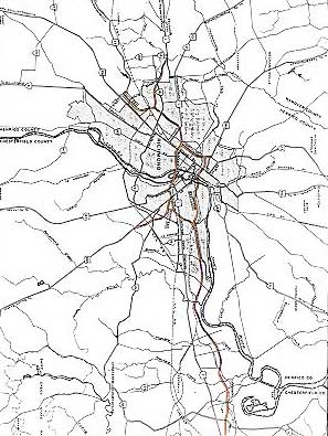
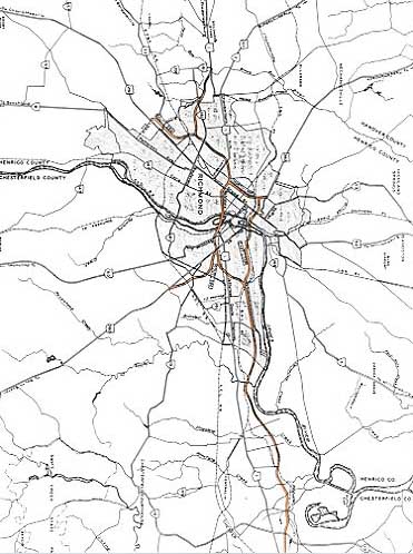
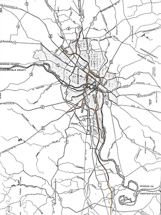
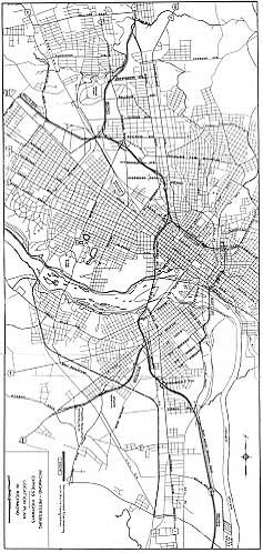
| Richmond
Interstates and Expressways |
From 1946 onward, there was much local discussion and debate about building
a modern system of urban and metropolitan freeways and bridges for the Richmond,
Virginia metropolitan area. This article traces the history of the development
of the system, mostly focusing on the
City of Richmond,
but also including regional highways.
The table of contents below has internal links on this page to sections of
this article. You can mouse click the link to go to that section, and hit the
"Back" key on your browser to return to the table of contents.
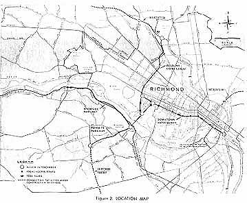
Richmond Metropolitan
Area Expressway and Highway Planning
Richmond-Petersburg
Turnpike
Location of Interstate
64
Early
Expressway Studies
Engineering
Studies for RMA Expressways
City Expressway
System Final Planning
City
Expressway System Construction Starts
Downtown Expressway
Clears Legal Hurdles
Construction
of Downtown Expressway
Powhite Parkway
RMA Tolls and
Traffic
1968 Major
Thoroughfare Plan
Richmond Beltway
Post-Implementation
Review of RMA Expressways
Sources
Richmond Metropolitan Area Expressway and Highway
Planning
The official beginning of the planning for limited access highways in the Richmond
metropolitan area was the engineering report Report on Express Highways,
Through and Between the Cities of Richmond and Petersburg, Virginia which
evaluated various corridors for new highways, and this report was completed and
published in 1946. The regional planners from then until the 1970s and later typically
used the word 'expressway' to describe these highways. The usage of 'expressway'
in their reports, in the local newspaper articles reporting on the system's progress,
and in my article here, means a divided highway with 4 or more lanes, with full
control of access, and full grade separation and access only at interchanges.
The proper technical term that is used by engineers and other transportation professionals
is the term "freeway", whose root was derived from meaning "freedom from at-grade
crossings and freedom from adjacent property driveway access"; it doesn't derive
from whether or not tolls are charged on the highway. So a tollroad like the Downtown
Expressway is correctly identified as a 'freeway'. Since 'expressway' is used
locally and in the historical media references in most instances, I most commonly
will refer to these highways as 'expressways' in this article.
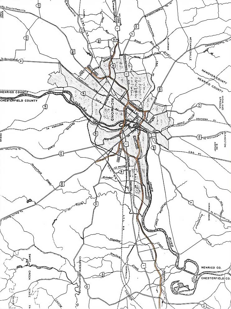
This was a prominent local issue from the end of World War II onward as the
post-war boom in the economy and in traffic led to much discussion about building
a modern system of new highways for the Richmond metropolitan area, to adequately
handle the high and increasing traffic demands. The city and metropolitan area
sits astride the US-1 and US-301 highways, the main north-south interstate highways
for the Eastern Seaboard prior to the building of Interstate Route I-95. The city
and metropolitan area is also bisected by the James River, a shallow rocky river
over 1/2-mile wide west of the downtown, becoming a deep-water ship-capable river
from the downtown eastward. The Shockoe Valley forms a deep valley just east of
the downtown. The various transportation barriers and the heavy city and regional
traffic combined with the need to handle heavy north-south interstate traffic,
by 1945 brought about the need for the development of a modern system of expressways,
bridges and thoroughfares.
The Richmond and Petersburg areas became industrial and manufacturing centers
in the early years of the United States, and in the antebellum period (pre-Civil
War period) this expanded and the two cities became major transportation hubs
when major railroads (Chesapeake and Ohio, Norfolk and Western, and Atlantic Coast
Line) were built through the area. Richmond is also the state capital and is in
the central region of the state, so in addition to its own industry, commercial
activities, tourism, and state government offices, it is a natural hub for transportation,
which includes a major commercial jet airport,
Richmond International Airport (RIC),
which is in Henrico County east of Richmond; and a major port, the Richmond Marine
Terminal, which is on the James River in South Richmond. The Richmond-Petersburg
metropolitan area has just reached one million population, in the 2000 census.
I-95 was completed north-south through the Richmond area in July 1958 as the
Richmond-Petersburg Turnpike (RPT). I-64 was completed east-west through the Richmond
area in 1968. I-95 parallels US-1/US-301, and I-64 parallels US-60 east of the
downtown, and I-64 parallels US-250 northwest of the downtown. I-64 and I-95 overlap
and share the same route for 4 miles in north Richmond.
The National System of Interstate and Defense Highways was established by the
U.S. Congress with the Federal-Aid Highway Act of 1956, with 41,000 miles of routes
to be built nationwide, and 1,500 miles of mostly metropolitan sections was added
to the system in 1968. I-95, I-64 and I-295 were among those approved in the 1956
Interstate system. For history of the Interstate Highway System, see
Federal-Aid Highway Act of 1956: Creating The Interstate
System by Richard F. Weingroff (U.S.
Department of Transportation historian), 1996.
I-95 has 6 lanes throughout the Richmond area; it was built with 6 lanes from
the Maury Street interchange northward, and with 4 lanes southward of there; and
the 22-mile-long section from Maury Street to the I-85 interchange in Petersburg
was widened to 6 lanes from 1974 to 1978.
Richmond-Petersburg Turnpike
The Richmond-Petersburg Turnpike Authority was established in 1955 to build
the Richmond-Petersburg Turnpike. The Authority was a small state agency created
by the General Assembly, to administer (design, finance, acquire right-of-way,
construct, operate, collect tolls, and maintain) the Turnpike. The Richmond-Petersburg
Turnpike (RPT) cost $76.7 million (funded with proceeds from toll revenue bonds
sold by the Commonwealth of Virginia) to build, and it ran for 34.7 miles from
US-1 in Dinwiddie County to US-301 in Henrico County (from today's I-85 Exit 63
to I-95 Exit 82), it opened in its entirety on July 1, 1958; and soon after opening,
the RPT was designated with the I-85 and I-95 designations, even though no federal
aid was used to build the RPT, and it became part of the Interstate system.
The original bond issue was retired in January 1975, but another $103 million
of toll revenue bonds was issued in December 1973 to pay for the 22 miles of 6-lane
widening from Maury Street in South Richmond to the I-95/I-85 interchange in Petersburg,
plus other improvements to the Turnpike, including a new ramp at the Broad Street
interchange in downtown Richmond, a complete reconstruction of the VA-150 Chippenham
Parkway interchange, improvements to the VA-10 interchange, and a complete reconstruction
of the Washington Street interchange and I-95/I-85 interchange in Petersburg,
and reconstruction of the I-95 highway mainline in Petersburg to lessen several
curves. This new interchange complex between I-95 and Washington Street, Wythe
Street and I-85 in Petersburg, was called the "Little Mixing Bowl" by the highway
designers and planners.
The 1973 General Assembly passed legislation to dissolve the Richmond-Petersburg
Turnpike Authority and transfers its duties, powers and obligations to the Virginia
State Highway Commission (the predecessor of the current Commonwealth Transportation
Board), so the Virginia Department of Highways and Transportation (today's VDOT)
took over administration of the RPT in 1973. Source: "Richmond-Petersburg Turnpike
Suffers Widening Pains", Virginia Road Builder magazine, October
1976.
My article
Richmond-Petersburg
Turnpike (I-95/I-85) and I-295 has more
history about the Turnpike and the I-295 bypass.
Local automobile commuters could buy booklets of toll tickets that cost about
one cent per mile of travel, in other words, 32 cents to travel the whole 34.7-mile-long
turnpike, or 8 cents per mainline toll plaza. Especially in the later years, that
was seen as rather inexpensive as the general rate of consumer price inflation
increased. The full (non-commuter) rate was 25 cents per mainline toll plaza,
increased to 50 cents in March 1989.
The $103 million of 1973-issued toll revenue bonds used to pay for the 6-lane
widening projects were paid off and retired in 1985. The last 7 years (1985-1992)
of toll revenue (mostly Northerner and Floridian toll revenue since the locals
could buy heavily discounted commuter tickets) was used to build 5 local road
projects. These projects were 6.5 miles of the VA-288 beltway between VA-10 and
US-1/US-301 in Chesterfield County, 3.5 miles of 2-lane parallel roadway (dualization)
for the VA-144 Temple Avenue Extension from Conduit Road in the City of Colonial
Heights to VA-36 near the City of Hopewell, 0.6-mile of the mostly 4-lane Leigh
Street Extension from near the Department of Motor Vehicles central office to
VA-161 Boulevard in the City of Richmond, 0.7-mile of 4-lane widening and reconstruction
of Belt Boulevard in the City of Richmond between VA-10 and Terminal Avenue, and
the 4.4-mile-long 4-lane limited access VA-150 Parham-Chippenham Connector between
1/2 mile south of Forest Hill Avenue in the City of Richmond and 1/2 mile north
of River Road in Henrico County. Legislation of the General Assembly in 1983 (Senate
Bill 304) provided for this toll extension and usage of the toll revenues for
these local road projects. These five local road projects were all completed by
1991. Due to a later shortfall of funding to complete the projects, the Commonwealth
Transportation Board (CTB) authorized the March 1989 toll increase to cover the
shortfall.
The Richmond-Petersburg Turnpike's I-85 portion become toll-free in 1986, when
Federal Highway Administration (FHWA) funds were used to finance most of the project
for the new interchange between Squirrel Level Road and I-85 (completed in 1987)
in the City of Petersburg; and the mainline Dinwiddie County Toll Plaza near US-1
west of Petersburg was removed then. The 1989 CTB toll increase decision also
provided for the removal of the I-95 Washington Street toll plaza in Petersburg,
thereby making toll-free the I-95 portion of the Turnpike south of the Ivey Avenue
interchange (completed in 1987, built to help support the Southpark Mall that
was built then) in the City of Colonial Heights; this interchange is less than
a mile south of the VA-144 Temple Avenue interchange. Actually Ivey Avenue was
not connected to the interchange, and the connecting road into the mall was later
named Southpark Boulevard. The 1989 CTB toll increase decision also provided for
the removal of the ramp toll plazas in the City of Richmond at the I-95/I-64/I-195
Bryan Park interchange and at VA-161 Boulevard, thereby making toll-free the I-95
portion of the Turnpike north of Boulevard.
So the mainline Richmond-Petersburg Turnpike toll plazas were ---
Concurrently with the foregoing studies, the Committee, through the City of
Richmond, retained the firm of White, Weld & Company of New York, to act as financial
advisors, and the firm of Wood, King, Dawson & Logan, also of New York, to provide
special bond council. After exhaustive study, these two firms collaborated in
recommending that enabling legislation be enacted to provide for a separate authority
as the best means for bringing the proposed project into reality.
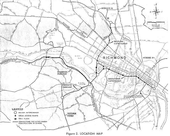
Enabling legislation creating the
Richmond Metropolitan
Authority (RMA) was enacted during the
1966 session of the Virginia General Assembly. This Authority is a small state
agency that was empowered to design, acquire right-of-way, construct, operate,
collect tolls, and maintain the Richmond Expressway System, again defined as the
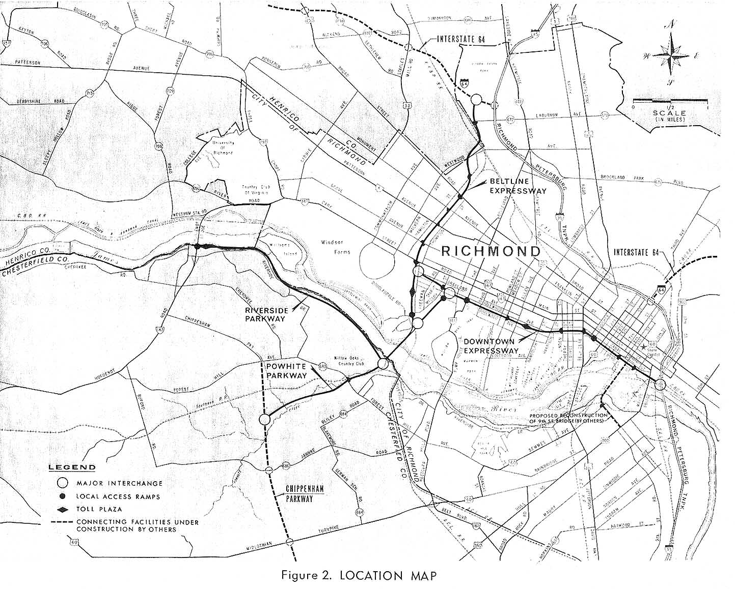
Powhite Parkway, Beltline Expressway, Downtown Expressway, and Riverside Parkway.
"On July 1, 1966, a Board of Directors was formed to govern the RMA. The Board
consists of 11 members. Six are appointed by the mayor of the City of Richmond
with the approval of the Richmond City Council. The Boards of Supervisors of the
Counties of Chesterfield and Henrico each appoint two members, and one ex-officio
member is appointed by the Commonwealth of Virginia Transportation Board. In addition
to the 11 board members, the RMA is guided by a Secretary and General Counsel
who takes the minutes of the meetings and provides legal assistance as needed".
See:
RMA Board of Directors & Executive Staff
The cost estimates in the 1966 report Richmond Expressway System
for engineering, right-of-way, construction, legal, administrative and contingencies,
were: Riverside Parkway, $7,406,000; Powhite Parkway, $11,585,000; Beltline Expressway,
$26,706,000; and Downtown Expressway, $45,274,000; for a total of $90,971,000.
The final as-built costs came to $135.5 million for the whole system: $20.7
million for Powhite Parkway, $51.2 million for I-195, and $63.6 million for the
Downtown Expressway.
Total initially proposed system - 13.78 miles (Powhite, Beltline, Downtown,
Riverside).
Total for completed system - 10.71 miles (3.38 Powhite, 3.44 I-195, 3.89 Downtown).
I'll make note, that the 1966 report named the segments differently from how
they were named after the expressway system was completed. The Powhite Parkway
ran from Chippenham Parkway to the north end of the James River Bridge. The Beltline
Expressway ran from the north end of the James River Bridge, along the railroad,
and to the I-64/I-95 Bryan Park Interchange. The North Connection Downtown Expressway
was the north leg of the delta interchange between the three expressways, the
South Connection Downtown Expressway was the south leg of the delta interchange,
and the Downtown Expressway ran from the east junction of the delta interchange
to I-95 in the downtown.
The naming of the expressways following completion has the Powhite Parkway
running from Chippenham Parkway to the I-195 Beltline/north leg of the delta interchange
junction at Cary Street, with I-195 continuing to the I-64/I-95 Bryan Park Interchange.
The north leg of the delta interchange is a leg of I-195. The Downtown Expressway
comprises the south leg of the delta interchange and the Downtown Expressway from
the east junction of the delta interchange to I-95 in the downtown.
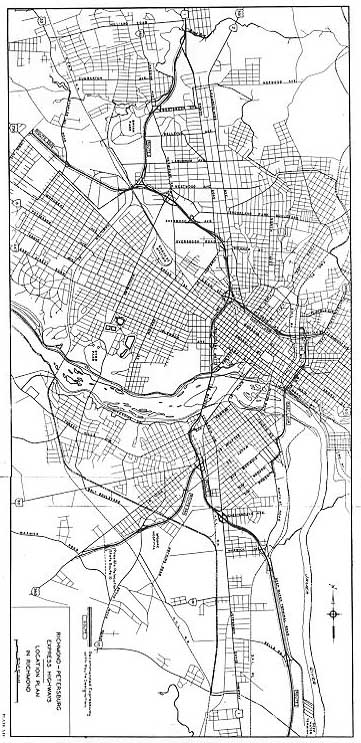
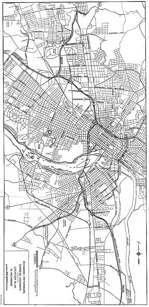
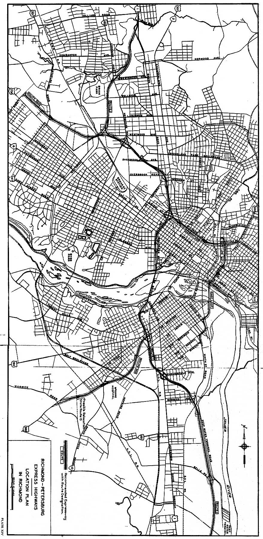
The article "Richmond Expressway Routes Disclosed", Richmond Times-Dispatch,
October 23, 1966, discussed at length the system after the route locations were
announced by the city and state for the 4 expressways, and there was a large map
of the proposed system. When I visited the Richmond Times-Dispatch
archives, I could see that there were numerous newspaper articles every year from
1946 onward about the development of the regional expressway system, which in
the earlier years included the development of the north-south Richmond-Petersburg
Turnpike which was completed in 1958 and the east-west I-64 which was completed
in 1968.
Both the
Richmond Times-Dispatch
and the Richmond News-Leader tracked the development of the expressways.
The Richmond Times-Dispatch is the regional morning newspaper, and
the Richmond News-Leader was the regional afternoon newspaper until
it and its staff merged with the Richmond Times-Dispatch in 1992.
Both newspapers are well respected with wide circulation, and the Richmond
Times-Dispatch today has the largest circulation of any Virginia-based
newspaper.
Excerpts from the article "Richmond Expressway Routes Disclosed", Richmond
Times-Dispatch, October 23, 1966, (blue text):
Recommended routes for the proposed Richmond Expressway System were disclosed
yesterday showing that there would be four major highway segments and a new bridge
across the James River. Costing $95 million, the facilities would provide rapid
travel routes east and west from the Huguenot Bridge to downtown and the Richmond-Petersburg
Turnpike's James River Bridge. North and south expressways would be built running
from the Interstate 64 / Richmond-Petersburg Turnpike interchange at Bryan Park
to Chippenham Parkway in Chesterfield County.
[that paragraph was at the beginning of
the front page article]
Charles A. Taylor, chairman of the Richmond Metropolitan Authority, said yesterday,
"The board of the Richmond Metropolitan Authority is highly pleased that relief
from a great deal of our area's traffic congestion has been brought in sight by
the two years of energetic work of the trafficways committee which we have inherited".
"It is the belief of our board that a system of expressways will be of inestimable
value to the citizens of our community by making it more convenient, more comfortable,
more prosperous, and more beautiful. We look forward to working with engineers,
financiers, legal experts, administrators and the public to bring an expressway
system into being just as rapidly as possible and we are resolved to do our very
best to find solutions to the many problems that will face us".
The article then went on and discussed details of each of the four expressways.
The expressway plan was developed during more than two years of work by City
Council's Committee on Trafficways. Now the committee's work has been turned over
to the Richmond Metropolitan Authority, an 11-member agency created by the 1966
General Assembly. The governments of Richmond, Henrico and Chesterfield and the
State Highway Commission all appoint representatives to the authority. The final
selection of the routes is in the hands of the authority.
The article has a map showing the proposed locations of the four expressways,
and it has a photo of George W. Cheadle pointing at an aerial rendering of the
proposed expressways near the City Stadium. Cheadle was the City Manager's Aide
who was appointed to direct the Richmond Metropolitan Authority (RMA), and he
served as its General Manager during its early years, and he held that position
from then through the completion of the expressways.
City Expressway System Final Planning
The entire 10.7-mile-long highway system of Powhite, Beltline and Downtown,
costly urban expressways with nearly 2/3 of the distance depressed, could have
been built by RMA as planned as tollroads if not for worsening national economic
conditions, especially major price inflation which drove costs upward. In 1968,
RMA advertised for bids on the 10 scheduled projects, and all but one exceeded
the engineers' estimates. Under the Authority's financing plan, the projects could
not be awarded. That and an unfavorable bond market brought RMA's expressway building
plans to an unexpected halt.
The first bond sale did not occur until 1971, at 7% interest on the issue of
$51,300,000. This was used to retire $22,000,000 in "Temporary Loan Notes", of
which $21,000,000 had been underwritten by the City of Richmond, to finance the
construction of the Powhite Parkway and the Beltline Expressway Connector to Cary
Street. By this time, the Riverside Parkway had been eliminated from the expressway
system plan.
The 1972 General Assembly decided to assign 0.9 mile of the Downtown Expressway
(from Davis Avenue to McCloy Street) to VDHT to be built as an Urban System project
with 100% state highway funds (no federal funds), thus relieving RMA from building
that section as part of its toll revenue bond financed toll road system. It was
called VDHT Project 0088, and VDHT administered the project, and it essentially
extended the I-195 highway eastward from the southern limit of I-195. Actually
Project 0088 cannot be driven by itself without using part of the toll system
also, still, the fact that it was built with state highway funds, meant that this
lowered the amount of toll revenue bond funding needed for the whole expressway
system.
The key item that advanced the expressway system plans was getting the Beltline
Expressway added to the national Interstate highway system as Interstate route
I-195, thus obtaining approval for financing it with 90% federal funding from
the Highway Trust Fund and 10% state highway funding, and thus obviating the former
plan to use RMA toll revenue bonds to finance the construction of the highway.
This provided for a toll-free I-195, and a considerably lower mileage that was
to be built as toll roads; just the Powhite Parkway and the Downtown Expressway
were built as toll roads. Source: "Richmond Expressway System Progresses",
Virginia Road Builder, September 1974.
The history of I-195 is a direct part of this article, but I have a separate
website article about that, and I will direct the reader to my website article
I-195 Beltline Expressway
to read that portion, and the continuity of this article flows from this point
here, to the I-195 article, and then back to this point here again.
The I-195 construction began in May 1971 and the Beltline Expressway portion
of I-195 opened on July 15, 1975. The I-195 connector to the Downtown Expressway
opened on February 3, 1976 along with 2.7 miles of the Downtown Expressway.
The "Beltline Expressway" name never caught on in public usage, perhaps because
the name is not posted on any road sign, and I have not seen it on any commercial
maps either, including the early and later RMA maps of the expressway system that
were distributed to the public after the system opened. The highway is commonly
known simply as "I-195" and local radio traffic reporters sometimes call it the
"195 Beltline".
The RMA did indeed build the Powhite Parkway which opened in January 1973,
and the Downtown Expressway which opened in 1976, although the 2 southerly ramps
to I-95 was opened in 1977. RMA continues to administer these highways today.
The Riverside Parkway was cancelled as mentioned before. The I-195 Beltline Expressway
was built by the Virginia Department of Highways and Transportation (VDHT) as
a toll-free Interstate highway.
I-195 has 6 lanes throughout, except for the 4-lane connector between the Beltline
Expressway and the Downtown Expressway. The Powhite Parkway was built with 6 lanes
from the south junction of the Stadium Interchange (the spread delta interchange
between the Beltline, Powhite and Downtown expressways) to Forest Hill Avenue,
and 4 lanes elsewhere; although the highway was widened in 1989 to 10 lanes from
the Stadium Interchange to Forest Hill Avenue, and 6 lanes on the remainder of
the highway. The Powhite Parkway section from the Stadium Interchange to Forest
Hill Avenue includes a James River bridge 1,971 feet long, and in the present
10-lane configuration, this 1.4-mile-long section is the widest highway in the
Richmond area. The Downtown Expressway has 6 lanes between the east junction of
the Stadium Interchange and US-1/US-301 Belvidere Street, and 4 lanes from Belvidere
Street to the elevated I-95 interchange, and the Downtown Expressway Connector
to Powhite Parkway (the south leg of the delta interchange) has 4 lanes.
City Expressway System Construction Starts
As mentioned before, in 1968, RMA advertised for bids on the 10 scheduled projects
for the Powhite, Beltline and Downtown expressways, and all but one exceeded the
engineers' estimates, and under the Authority's financing plan, the projects could
not be awarded. The worsening national economic conditions, especially major price
inflation which drove costs upward, and an unfavorable bond market brought RMA's
expressway building plans to an unexpected halt. The approval in 1969 to build
the Beltline Expressway as a toll-free Interstate highway was a major financing
breakthrough, and it was placed under construction in May 1971. More favorable
bond interest rates were found, and bond issue sales began in 1971, as did construction
of the Powhite Parkway and Beltline Expressway. Source: "Beltline Expressway I-195
Spur Built", Virginia Road Builder, October 1974.
There were minimal property relocations on the Beltline Expressway project,
including 14 residential dwellings, and 10 commercial and industrial properties.
As was said before, it mainly follows the depressed Beltline Railroad, and the
elevated northern portion passed through some commercial and some undeveloped
areas.
The Powhite Parkway's construction projects cost $17.79 million (source: "Beltline
Expressway I-195 Spur Built", Virginia Road Builder, October 1974),
and had 2 residential dwellings acquired, as the parkway was constructed generally
in the flood plain of Powhite Creek and involved relocation of portions of the
creek. As you can see, the "Powhite" name came from the creek that generally parallels
the parkway. The Powhite Parkway was completed and opened on January 24, 1973,
and it runs from Cary Street to Chippenham Parkway. The median widens out to several
hundred feet wide at one point between the main line toll plaza and Chippenham
Parkway; it can be seen in the 1966 engineering study Richmond Expressway
System that this was originally intended to contain a lake with a scenic
overlook and parking area accessed by ramps to and from the left lanes of the
parkway. The highway itself was designed and built to accommodate this feature,
but I have not yet found any source that documents why it was never developed.
The Powhite Parkway has parkway-like design features along much of its length,
but it is a full-fledged expressway that allows cars, buses, and large trucks,
and it is an integral part of the regional expressway system that handles local,
regional, interregional, and interstate traffic. The heavy traffic volumes would
seem to make usage of such a median scenic overlook to be problematical.
So the Powhite Parkway and Beltline Expressway projects advanced to construction
quickly, due to the above stated conditions of minimal property acquisition impacts
and minimal financing problems.
Downtown Expressway Clears Legal Hurdles
The development of the Downtown Expressway had much larger hurdles to cross,
with its large-scale property acquisition impacts, its high cost, its impacts
to parkland at the north edge of Byrd Park, and its impacts to canal artifacts
in the downtown. The canal artifacts in the downtown was the focus of a group
of citizen activists who filed a lawsuit in 1973 to attempt to block the construction
of that segment of the Downtown Expressway. The lawsuit was filed at the U.S.
District Court on January 9, 1973, and rejected by Judge Robert R. Merhige, Jr.
on May 8, 1973, and the group appealed to the 4th U.S. Circuit Court of Appeals,
and the appellate court rejected the appeal on August 17, 1973. Both of these
courts are located in Richmond. The group considered an appeal to the U.S. Supreme
Court, but did not file one, and the group publicly dropped any further court
action on September 11, 1973. That essentially cleared the way to the awarding
of all mainline construction contracts on the Downtown Expressway.
The Downtown Expressway is one of the very few urban highways in Virginia that
had large-scale relocations of residences and businesses. There were over 700
residential dwelling units relocated from the path of the expressway, mainly in
the Randolph, Sydney and Oregon Hill neighborhoods (this included the north leg
of the delta interchange between the three expressways), and there were almost
150 business relocations, mainly in the downtown area and in the area just west
of the downtown. After RMA and the City Council approved the location and design
of the expressway in 1966, the City Council passed condemnation ordinances so
that negotiation with property owners could be undertaken to acquire the properties,
and to use the power of eminent domain to condemn a property if a negotiated settlement
could not be achieved. Appropriate cash settlements were provided in either case
to pay the market value of the property acquired, plus the relocation expenses,
plus additional damage payments as deemed necessary. The city housing authority
and other city agencies participated in relocating the affected residents and
businesses. The acquisitions were begun in 1967 and were completed by 1968 with
the right-of-way cleared and buildings demolished.
Richmond, like many other cities in the 1800s, had built a large canal system
for commerce, and much of the system was filled in and redeveloped in the 1900s.
Portions of the James River and Kanawha Canal system still exist today, and major
portions along a 2-mile length in the downtown were restored and reopened in 1999
to pleasure boat and park use. A very attractive long linear urban park is the
result, and there are a few other candidate portions that might be restored also.
One branch of the canal system included a turning basin and 2 locks in the
area bounded by Canal, 12th, Byrd, and 7th Streets. Due to a number of large commercial
buildings including the Ethyl Corporation headquarters complex, and a large state
prison complex, the expressway planners found that the least impacting route east
of Belvidere Street (US-1/US-301) was to build the expressway between Canal Street
and Byrd Street, which parallel each other a block apart. The route used the entire
city block width for right-of-way on a depressed 6-lane cross-section with sloped
earthen embankments, from Belvidere Street to 2nd Street, and east of there the
cross-section narrows down to 4 lanes with retaining walls so that a half-block
width of large commercial buildings could be retained. This least impacting route
passed over the canal artifacts mentioned above, and these had been completely
filled in with earth almost 100 years before, and were being used for parking
areas in 1970. Still, the walls of the canal and locks were made of large blocks
of hewn stone, and had historical significance even though they were buried underground.
In March 1972, an organization called James River and Kanawha Canal Parks,
Inc. was incorporated by a citizen group that wanted to restore this and other
portions of the old city canal system into a urban park and tourist attraction,
and they lobbied to have the Downtown Expressway terminated at 5th Street, or
perhaps even as far west as Belvidere Street, with the cancellation of the extension
through the downtown to I-95. This is the group that I mentioned before that filed
the lawsuit against the project. The group sued for a court injunction to force
the compilation of an environmental impact statement (EIS) pursuant to the National
Environmental Policy Act of 1970 (NEPA). They also argued that the canal artifacts
should be considered a navigable waterway protected under the federal River and
Harbors Act, needing a permit from the U.S. Army Corps of Engineers (ACoE) before
the expressway could be built through it.
The defendant's (RMA and other state and federal parties) attorneys successfully
argued that since no federal funds were involved in any part of the Downtown Expressway
project, that this was not a federal issue and that the NEPA EIS was not applicable.
RMA attorneys also successfully argued that the canal artifacts in that five-block
stretch were in no way to be considered a navigable waterway, since they were
completely filled in and covered with earth, and that the land use of that area
had not been canal-related in almost 100 years. Judge Merhige filed a 51-page
memorandum opinion and accompanying order, which was designed to provide adequate
supporting documentation should the decision be appealed to the appellate court.
The plaintiff's attorneys provided counter-arguments that the project should
be considered federal (and subject to NEPA EIS) since the Downtown Expressway
connects two Interstate highways, I-195 and I-95, and that the Expressway is essentially
an extension of the federally-funded I-195. The plaintiff's attorneys also argued
that since the canal had never been officially de-designated from federal status
as a navigable waterway, that it should still be considered with that status,
and subject to ACoE review and permitting.
The defendant's attorneys successfully argued that those counter-arguments
were bogus, since the Downtown Expressway was an independent highway in its own
right, even though it was part of a regional expressway system; also, that I-95
in Richmond was a state-funded tollroad (no federal funds were used); also, that
the Downtown Expressway is not an extension of I-195, but is a distinct route
in and of itself; also, that the canal could not be considered a navigable waterway
since it was completely filled in and covered with earth, and that it was missing
the most necessary ingredient of all, namely water, and that only through expensive
major reconstruction could the canal be restored to a navigable waterway. Also,
the EIS process established under NEPA of 1970 was still a new process, and the
early 1970s still saw some federally-aided highway projects conceived in the 1960s
being granted approval under the grandfathering concept, without an EIS.
Judge Merhige stated at one point while rendering the decision, "The protection
of our environment and of our places of historical importance are of utmost importance,
yet the decision as to how to protect them must come from the Congress of the
United States and the legislatures of the various states. Where, as here, highway
planners meet all of the requirements of law applicable to them, nothing further
is required". Source - "Judge Rejects Legal Bid To Halt City Expressway",
Richmond News-Leader, May 8, 1973.
The legal challenges of the citizen activist group were not supportable based
on the rule of law, and as I said, the challenges ended in September 1973. RMA
awarded all the Downtown Expressway construction contracts (except the one for
the two southerly I-95 ramps) between November 1973 and May 1974. The VDHT Project
0088 was awarded in July 1973.
Construction of Downtown Expressway
Much of the Downtown Expressway is depressed below grade, and over 3 million
cubic yards of earth needed to be excavated and trucked to remote disposal sites.
The planners decided that this was the most environmentally acceptable way to
build a freeway through urban and residential areas. An expressway built at surface
level would require the many street crossings to rise on earthen embankment approaches
so that they could pass over the expressway on overpass bridges, and those approaches
would usually require acquiring many developed properties. An elevated expressway
would pass over all crossing streets without changing their grade, but then there
would be a large elevated viaduct in and near urban areas, with the associated
high visual impact, plus maximized noise impacts radiating for a long distance
from the raised source. The depressed expressway would be built far enough below
grade so that normally the grade (vertical alignment) of the crossing streets
remained the same, with a bridge built so that the street could cross the expressway.
With the sound source well below the existing ground level, the noise is radiated
upward, providing much less traffic noise in nearby neighborhoods than with the
elevated or surface level expressway designs. The depressed expressway also is
not visible from ground level from more than about 50 feet away. The depressed
expressway does involve major design and construction challenges, since a large
amount of surplus excavation needs to be disposed of, and all crossing underground
utilities need to be relocated, and an elaborate storm sewer system needs to be
designed and built to gather the storm water that accumulates in the expressway
trench, and carry it away in underground water tunnel outfalls to local major
creeks and rivers. All factors considered, though, the depressed design fits better
into the urban environment, than do the others.
A reinforced concrete cover was built over the depressed expressway between
7th Street and 10th Street, to restore connectivity between the heart of the downtown
and the James River which is three blocks from the expressway. Landscaping was
built over the cover between 7th Street and 9th Street, with an attractive urban
park called Kanawha Plaza built over the expressway. From ground level, it looks
like a seamless urban surface and the expressway is underground and out of sight.
The Federal Reserve Bank tower was built in the late 1970s on the southwest corner
of the expressway/Byrd Street and 9th Street. The James Center development built
4 large, tall office buildings in the 1980s just north of expressway in the area
of Canal Street and 9th and 10th Streets. In the early 1990s, a large twin office
tower called Riverfront Plaza was built on the southeast corner of the expressway/Byrd
Street and 9th Street. In 1992, the Expressway Parking Deck opened, which is a
6-story parking garage that RMA built on top of the expressway cover between 9th
Street and 10th Street. So a lot of urban development has occurred in the downtown
area near the covered portion of the expressway since the expressway opened in
1976.
The proposed replacement of the old downtown 2-lane 9th Street Bridge over
the James River was mentioned briefly in both the 1963 Western Expressway
and Belt Line River Crossing engineering report, and in the 1966
Richmond Expressway System engineering report, since it was an actively
planned project in the same era that the expressways were being planned, and it
was interrelated with the Downtown Expressway from a traffic standpoint, as its
northern approach passes over the expressway. The new bridge's proposed location
was shown in the 1966 report, with the indication that it would be built "by others",
meaning that it was planned as a project separate from the expressway system.
Its planning, design and construction was handled as an Urban System project of
VDHT, meaning that it was primarily funded by VDHT, but included City of Richmond
funding too, and in effect was a joint city/state project. The replacement bridge
is named the Manchester Bridge (after the name of the part of the city that the
bridge connects to on the south shore of the river), and it is 2,909 feet long
and has a maximum roadway height above the river of 110 feet, and it opened in
1972. It has 6 lanes with shoulders and has a pedestrian walkway on the raised
median. See: Inside Richmond
"River Crossings".
Also, see my article
Richmond Downtown Aerial Photos
for photos of the Manchester Bridge and the elevated connection of the Downtown
Expressway with I-95.
The large blocks of hewn stone from the walls of the canal and locks, which
were removed during construction of the expressway, were taken to an RMA storage
area for future use, since they have historical significance. About 100 of them
were borrowed to form decorative terraces in an urban plaza next to the Omni International
Hotel downtown at Cary Street and 10th Street, when the hotel was built in the
early 1990s.
The Downtown Expressway route used the entire city block width between parallel
Canal Street and Byrd Street for right-of-way on a depressed 6-lane cross-section
with sloped earthen embankments, eastward from Belvidere Street (US-1/US-301)
to 2nd Street, and east of there the cross section narrows down to 4 lanes with
retaining walls so that a half-block width of large commercial buildings could
be retained. The easternmost 0.5 mile of the expressway rises onto a double-decked
viaduct with 2 lanes on each deck, and the expressway interchanges with the I-95
James River Bridge, with all ramps on bridge structure, tying into the I-95 bridge's
overland section.
West of Belvidere Street, the route typically used the entire city block width
(between parallel Cumberland Avenue and Idlewood Avenue just west of Belvidere
Street, and west of there between parallel Parkwood Avenue and Grayland Avenue)
for right-of-way on a depressed 6-lane cross-section with sloped earthen embankments.
On one two-block section near Cherry Street and Idlewood Avenue, there was a narrowing
of the right-of-way, and retaining walls were used to reduce the cross-section
to a half-block width, to avoid the St. Andrews Episcopal Church and Parochial
School in the Oregon Hill neighborhood.
The Downtown Expressway opened with 2.7 miles between 7th Street in the downtown
and I-195 and Powhite Parkway on February 3, 1976. On August 25, 1976, the 0.7-mile
section between 7th Street and I-95 was opened, although only the two northerly
ramps to I-95 opened then. The two southerly ramps with I-95 were delayed by the
permitting process where the U.S. Coast Guard needed to issue a permit to allow
RMA to build 5 bridge piers in the channel of the truncated end of the old city
canal, unused by marine traffic for over 30 years and largely silted in, with
or without standing water based on the amount of recent rainfall, but still considered
a navigable waterway by the Coast Guard. The permit was issued and the ramps were
constructed and opened on September 1, 1977, thus completing the RMA expressway
system. The final cost of the 3.4 mile Downtown Expressway was $63.6 million for
engineering, right-of-way, utilities and construction. Sources: "Expressway to
Open", Richmond News-Leader, February 2, 1976; "Richmond Expressway
System Progresses", Virginia Road Builder magazine, September 1974.
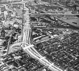
There is a spread delta interchange (called the Stadium Interchange by RMA)
near the University of Richmond Stadium (named City Stadium when the expressways
were built); between I-195, the Downtown Expressway and the Powhite Parkway; each
leg essentially provides a through-expressway connection between the expressways.
The I-195 Beltline connector to Powhite Parkway has 6 lanes (originally 4 lanes
and widened in 1990), and the other two legs of the Stadium Interchange have 4
lanes. Each of the three connector legs of the Stadium Interchange have local
interchanges.
The Downtown Expressway has 6 lanes (with a 44-foot-wide median that can accommodate
2 future additional lanes with 2 full emergency left shoulders and a New Jersey
Median Barrier) between the Stadium Interchange (easterly junction) and Belvidere
Street, and 4 lanes between Belvidere Street and I-95, with the 44-foot-wide median
continuing eastward to 2nd Street where it narrows down to 18 feet between 5th
Street and the elevated viaduct connector to I-95. The Downtown Expressway connector
to the Powhite Parkway has 4 lanes with an 18-foot-wide median, and the portion
of I-195 between the Beltline Expressway and the Downtown Expressway has 4 lanes
with an 18-foot-wide median. The 44-foot-wide medians have 6-foot paved left shoulders
and the remainder grass, and the 18-foot-wide medians are paved and have a New
Jersey Median Barrier. The entire portion of I-195 that follows the Beltline Railroad,
has 6 lanes, and each roadway has a 12-foot-wide emergency shoulder on the right
and a 7-foot-wide emergency shoulder on the left; and retaining walls restrict
the possibility of widening with additional lanes. The Downtown Expressway and
its legs of the delta interchange, have 10-foot right shoulders. North of the
river including the James River Bridge, the Powhite Parkway has 10-foot right
shoulders and 6-foot left shoulders; south of the river it has a paved median
with a New Jersey Median Barrier, and 10-foot grass right shoulders.
See this link of mine for a map of the Downtown Expressway and the Stadium
Interchange -
Downtown
Expressway (749K). From map A
Guide to Richmond's Expressway System, by Richmond Metropolitan Authority,
1977.
Powhite Parkway
The 3.4-mile-long Powhite Parkway has 10 lanes between the Downtown Expressway
and Forest Hill Avenue (this section includes the James River Bridge), and 6 lanes
between Forest Hill Avenue and Chippenham Parkway, and 6 lanes between I-195 and
the Downtown Expressway. The Powhite Parkway was originally built with 6 lanes
between the Downtown Expressway and Forest Hill Avenue, and 4 lanes between Forest
Hill Avenue and Chippenham Parkway, and 4 lanes between I-195 and the Downtown
Expressway; the widening was completed in 1989. The James River (Powhite Parkway)
Bridge is 1,971 feet long and has a maximum roadway height above the river of
45 feet, and it opened in 1973. It has 10 lanes (5 each way) with 10-foot right
shoulders. See: Inside Richmond
"River Crossings".
The 10-mile-long 4-lane VA-76 Powhite Parkway Extension was built by VDOT from
1986 to 1988, and it is a VDOT-administered toll road that cost $89 million to
build, and it extends the RMA Powhite Parkway westward into Chesterfield County,
ending in junctions with the VA-288 beltway and VA-652 Old Hundred Road. The mainline
toll plaza is 1/2 mile west of Courthouse Road, and the automobile toll has been
$0.75 since the highway opened in November 1988. The 2.8 miles of VA-288 between
US-360 and VA-76 was funded and built as a part of the Powhite Parkway Extension
program, and VA-288 is toll-free.
A further 8-mile-long westward Powhite Parkway extension to US-360 in the Winterpock
area has been discussed various times in the last 20 years, but no actual VDOT
funding for preliminary engineering has yet been provided, although the project
is listed in the 2023 long range transportation program for the Richmond area's
Richmond Regional Planning District Commission.
In March 2003, VDOT received an
Unsolicited PPTA Proposal from Powhite Parkway Partners, LLC, to design and build
the Powhite Parkway Western Extension under the
Public Private
Transportation Act, by 2009 as a toll road.
Proposal in PDF format -
Powhite Parkway Extension
Designing, building, and financing an extension of the Powhite Parkway toll
road facility from its current terminus at Route 288 to Route 360.
Public
notice for the Powhite Parkway Extension unsolicited proposal in PDF format.
All of these toll expressways, and the VA-161 Boulevard Bridge over the James
River, use the
Smart Tag
system of electronic toll collection (ETC), which was implemented in 1999 at a
cost of $25 million to supplement the manual and automatic toll collection booths.
Quote (blue text):
Smart Tag is an electronic toll collection system that lets you pre-pay tolls.
It's easy, convenient and hassle-free. As you approach the clearly marked toll
lanes on the Smart Tag facilities, the transponder on your vehicle communicates
electronically with a computer in the lane. Immediately, the amount of the toll
is subtracted from your prepaid Smart Tag account. The light turns green, and
you continue on your way.
RMA Tolls and Traffic
Here is a brief history of toll rates and toll collection on the RMA Powhite
Parkway and the RMA Downtown Expressway, using the RMA website in February 2009 as
the source of information. The original automobile mainline tolls were, the Powhite
Parkway was 20 cents, and the Downtown Expressway was 15 cents. On July 30, 1978,
tolls on Powhite increased from 20 cents to 25 cents, and on Downtown Expressway
from 15 cents to 25 cents. On November 1, 1986, automobile tolls on both the Powhite
Parkway and the Downtown Expressway increased from 25 cents to 30 cents. On June
1, 1987, toll tokens were introduced. On April 2, 1988, tolls on both the Powhite
Parkway and the Downtown Expressway increased from 30 cents to 35 cents. In October
1994, RMA and VDOT announced survey results where the public was surveyed about
instituting electronic toll collection (ETC) on Richmond area toll highways and
bridges, and the public favored it by a large margin. On January 5, 1998, automobile
tolls on Powhite and Downtown Expressway increased from 35 cents to 50 cents.
On July 1, 1999, the ETC system called Smart Tag was implemented by RMA. Smart
Tag does not eliminate manual and automatic toll collections, it augments it.
On October 27, 2004, Smart Tag merged into the
E-ZPass consortium that
a number of states utilize for electronic toll collection.
On September 7, 2008, a $24 million project was completed to provide open
road tolling at the Powhite Parkway mainline toll plaza, and this provides
three high-speed freeway-standard lanes in each direction for E-ZPass users,
and a conventional toll plaza in each direction with provisions for cash,
exact change, and E-ZPass, and this project has eliminated a major traffic
bottleneck on the parkway. The mainline Powhite Parkway toll plaza is 1/2 mile
southwest of Forest Hill Avenue. On September 8, 2008, automobile mainline
tolls on Powhite Parkway and Downtown Expressway increased from 50 cents to 70
cents. The Forest Hill Avenue interchange has a total of eight toll lanes on
its three on- and off-ramps with Powhite Parkway, and its toll rate is the same
as the mainline Powhite Parkway toll plaza. The mainline Downtown Expressway toll
plaza has 12 lanes, and it is located near Lombardy Street and Parkwood Avenue,
and four of the toll plaza lanes there are reversible. The E-ZPass-only lanes are
in the middle of a directional group of mainline toll lanes, and the speed limit
is 10 mph. There are a variety of ramp tolls on some ramps of the RMA system.
Here is a brief traffic volume summary on the RMA Powhite Parkway and the RMA
Downtown Expressway, using the RMA website in February 2009 as the source of information.
An average of approximately 54,000 vehicles utilize the Downtown Expressway each
day. An average of nearly 90,000 vehicles travel on the Powhite Parkway each day,
with that figure rising to nearly 100,000 on peak days. Official VDOT traffic
data shows that large trucks comprise 4% of the traffic on each highway.
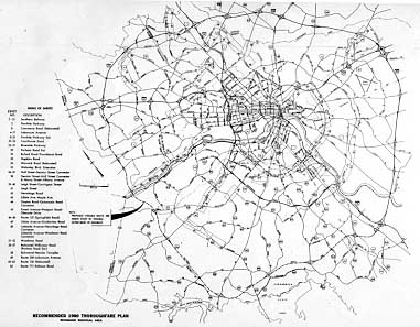
1968 Major Thoroughfare Plan
The first planning study for circumferential highway routes in Chesterfield
County was Chesterfield Circumferential Routes, Location and Design Study,
Inner Route - Middle Corridor - Outer Corridor, prepared by Virginia Department
of Highways, September 1962. The study looked at alternatives for inner, middle
and outer circumferential highways, and this was the official genesis for what
later became the Chippenham Parkway and the VA-288 beltway.
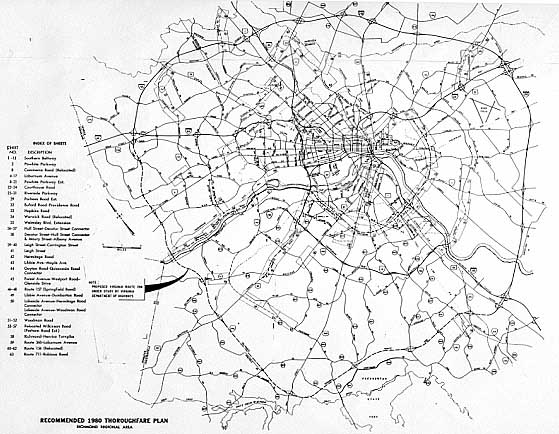
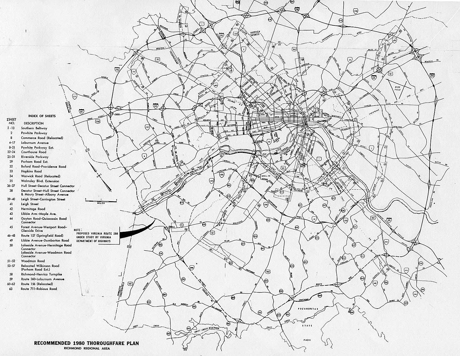
The following report is the 1968 major thoroughfare plan for the Richmond area.
Richmond Regional Area Transportation Study, Volume 5 "Recommended
Thoroughfare Plan - Street Inventory, Functional Plans, and Cost Estimates", engineering
report prepared in cooperation with Richmond Regional Planning Commission, City
of Richmond, Henrico and Chesterfield Counties, Richmond Metropolitan Authority,
Virginia Department of Highways, U.S. Department of Transportation, Federal Highway
Administration, Bureau of Public Roads, and the U.S. Department of Housing and
Urban Development. Prepared by consultant Wilbur Smith and Associates, 1964-1968.
The study Richmond Regional Area Transportation Study represented
the high-water mark for highway and expressway planning in the region. The full
expressway system from Richmond Expressway System was shown; the
3.4-mile-long Powhite Parkway, the 3.9-mile-long Downtown Expressway, the 3.1-mile-long
Riverside Parkway, and the 3.4-mile-long I-195 Beltline Expressway which got approval
for 90% federal funding as an Interstate highway in 1969 (the National System
of Interstate and Defense Highways was approved for 41,000 miles of routes in
1956, and in 1968 1,500 miles was added to the system, mostly for urban beltways
and spurs). The Chippenham Parkway was shown as a full limited access highway
from I-95 to Huguenot Road, in the routing that was built by 1967 as a mostly-two-lane
highway with at-grade intersections and built on a 4-lane right-of-way, and with
its present route number, VA-150; and it was upgraded to full 4-lane freeway standards
between I-95 and Forest Hill Avenue in a series of projects from 1973 to 1982.
The Riverside Parkway was shown, from Powhite Parkway to Huguenot Road, plus a
proposed extension along the north bank of the James River, all the way west to
VA-288 near the county border of Henrico and Goochland Counties.
The Laburnum Avenue Extension was shown as a 4-lane extension of Chippenham
Parkway, from I-95, across the James River to Laburnum Avenue and VA-5 near Varina
in Henrico County; this general alignment is being used for the
Route 895 Connector
that began construction in October 1998. The report proposed a high-level bascule
span drawbridge over the James River, with 50 feet of vertical navigational clearance
when closed. When the I-95 Richmond-Petersburg Turnpike was widened 1974-1978,
the 3-way trumpet interchange between I-95 and VA-150 Chippenham Parkway was reconstructed
into a semi-directional interchange, and the design included provision for a future
second phase to extend VA-150 eastward over I-95 and over the river, with design
provision for 4 future ramps to complete the full 4-way freeway-to-freeway interchange.
The Route 895 bridge presently under construction will be a fixed high level bridge
with 145 feet of vertical navigational clearance.
A 6-lane expressway called the Southern Beltway was shown in this thoroughfare
plan. This is the only report where I've ever seen this proposed highway; I don't
think the concept ever took hold as a continuing regional desire. Essentially,
it would have been an extension of the Riverside Parkway from the Riverside Parkway/Powhite
Parkway interchange, 12.2 miles long, following just west of the Belt Line Railroad
corridor in south Richmond, running on a rough radius from the downtown just over
half the radius of today's Chippenham Parkway/Laburnum Avenue corridor, crossing
I-95 and the James River just north of the Richmond Marine Terminal (formerly
Richmond Deepwater Terminal), and ending with an interchange with I-64 west of
the Laburnum Avenue/I-64 interchange east of Richmond. The Southern Beltway would
have had 10 interchanges.
The VA-150 Parham-Chippenham Connector was not included in the 1969 report.
This was completed in 1990 as the 4-lane limited access VA-150 Chippenham Parkway
Extension, which includes the Edmund E. Willey Bridge over the James River, at
a cost of $56 million.
Richmond Beltway
In the 1968 major thoroughfare plan, the Richmond Beltway was shown proposed
as a complete 66.2-mile-long circumferential expressway around the region. The
36.2-mile-long portion north of I-64 and east of I-95 was proposed as I-295, and
the 30.0-mile-long portion south of I-64 and west of I-95 was proposed as VA-288.
The history of the I-295/VA-288 Richmond Beltway is a direct part of this article,
but I have a separate website article about that, and I will direct the reader
to my website article
Richmond Beltway (I-295 and VA-288)
to read that portion, and the continuity of this article flows from this point
here, to the Richmond Beltway article, and then back to this point here again.
Post-Implementation Review of RMA Expressways
A major article was published later, "Downtown Expressway has Benefited Richmond",
Richmond Times-Dispatch, September 12, 1986. The article provides
an interesting perspective about the expressway system about ten years after it
was completed. The article summarizes the main points that I have written in my
article here, and it provided a balanced discussion of the benefits of the expressway
and its impacts.
One of the main opponents to the Downtown Expressway during its planning stages,
was Councilman Henry L. Marsh III, an African-American who later served a term
as Mayor of Richmond, and he was quoted in this article. He discusses how he was
concerned about the major social costs of the expressway due to the major relocations
of homes and businesses, and how years later, he could see both tangible and intangible
value in the RMA expressway system.
Excerpts from the article (blue text):
"On the whole," he [Marsh] said recently, "I would say that the expressway
would be a positive, in that the downtown business district and the retail core
are essential elements to Richmond's progress and vitality. I think the expressway
is an asset to the city in that it certainly was a motivating factor in the development
of the financial district, in the Cary-to-Main Street area," he said. "Without
the expressway, that district would not have developed to the extent that it has.
And to that extent, I think it's certainly a plus."
Now Marsh says he uses the toll road "quite a bit" and does not dwell much
on the fact that the downtown leg of the RMA system eradicated a field where he
used to play ball and wiped out the Marsh family homestead at what used to be
the corner of Addison Street and Grayland Avenue. "It also serves as an integral
part of a network of roadways which enable Richmond to be in the forefront of
cities with progressive, effective highway systems, so that people can move from
one part of the Richmond area to any other part in a very short period of time,"
the councilman asserted.
"The Downtown Expressway and the RMA are not the entire network, but are an
integral part of that network. And I think to that extent it helps the entire
Richmond community become a more progressive place," Marsh said. "It puts us in
a good posture for the future."
The article goes on to quote attorney A. J. Brent, who had been general council
to the RMA since its inception. He stated that he believed that the city's supplementary
financial contributions over the years to RMA had more than paid for themselves
by the development stimulated by the expressway, and in particular cites the downtown
Federal Reserve Building, the Dominion Virginia Power (old VEPCO) building, and
the CSX development, as developments that probably would not have occurred if
not for the expressway system and in particular the downtown leg of the Downtown
Expressway.
Brent cited as a direct benefit of the expressways, that area residents have
an easy, comfortable, convenient and fast way to get to the downtown, and that
a financial plan was devised to pay for it at a time when neither the state nor
the localities could afford to build it. Brent and other RMA officials were cited
as believing that a major intangible benefit of the RMA's activities, is that
it helped foster a greater sense of cooperation between the City of Richmond and
the adjoining suburbs in Chesterfield County and Henrico County. Brent suggested
that RMA happened to be established at a time when the threat of city annexation
of county land had caused less than ideal public relations between the city and
the two counties.
Sources
1. Report on Express Highways, Through and Between the Cities of Richmond
and Petersburg, Virginia, engineering report prepared for the Department
of Highways of the Commonwealth of Virginia, by consulting engineers R. Stuart
Royer and Consoer, Townsend and Associates, Richmond, Virginia, 1946.
2. Transportation, a Master Plan Study, prepared by Segoe-DeLeuw,
1950.
3. Engineering Report, Richmond-Petersburg Turnpike, prepared by
Parsons, Brinckerhoff, Hall & MacDonald, August 1955.
4. Map Proposed Major Street and Highway Plan, which was approved
by the Richmond City Council in April 1959.
5. Chesterfield Circumferential Routes, Location and Design Study, Inner
Route - Middle Corridor - Outer Corridor, prepared by Virginia Department
of Highways, September 1962.
6. Western Expressway and Belt Line River Crossing, engineering
report prepared for City of Richmond, Virginia, by consulting engineers Howard,
Needles, Tammen & Bergendoff, June 1963.
7. Richmond Expressway System, engineering report prepared for Committee
on Trafficways, Richmond, Virginia, by consulting engineers Howard, Needles, Tammen
& Bergendoff, October 1966.
8. "Richmond Expressway Routes Disclosed", Richmond Times-Dispatch,
October 23, 1966.
9. Richmond Regional Area Transportation Study, Volume 5 "Recommended
Thoroughfare Plan - Street Inventory, Functional Plans, and Cost Estimates", engineering
report prepared in cooperation with Richmond Regional Planning Commission, City
of Richmond, Henrico and Chesterfield Counties, Richmond Metropolitan Authority,
Virginia Department of Highways, U.S. Department of Transportation, Federal Highway
Administration, and the U.S. Department of Housing and Urban Development. Prepared
by consultant Wilbur Smith and Associates, 1964-1968.
10. "Proposed Tollway Shift Held Costly", Richmond Times-Dispatch,
April 13, 1972.
11. "Judge Rejects Legal Bid To Halt City Expressway", Richmond News-Leader,
May 8, 1973.
12. Final Environmental/Section 4(f) Statement Administrative Action for
Interstate Route 295, Chesterfield, Hanover and Henrico Counties, by Virginia
Department of Highways, Environmental Quality Division, in cooperation with U.S.
Department of Transportation, Federal Highway Administration, May 1973.
13. "RMA Takes Legal Shot At Foes' Views Again", Richmond News-Leader,
August 9, 1973.
14. "RMA's Foes Lose Expressway Appeal", Richmond Times-Dispatch,
August 18, 1973.
15. "Tollway Foes' Dilemma: To Yield, or Renew Costly Battle", Richmond
News-Leader, August 30, 1973.
16. "Expressway Foes Drop Court Fight", Richmond News-Leader, September
11, 1973.
17. "Expressway Taking Shape", Richmond Times-Dispatch, May 26,
1974.
18. "Route of the Downtown Expressway", Richmond News-Leader, June
19, 1974.
19. "Richmond Expressway System Progresses", Virginia Road Builder,
September 1974.
20. "Beltline Expressway I-195 Spur Built", Virginia Road Builder,
October 1974.
21. "Beltline Slated To Open July 15", Richmond News-Leader, April
25, 1975.
22. "New Beltline Safe, Costly, Toll-Free", Richmond News-Leader,
July 14, 1975.
23. "A Ribbon Cutting in Richmond", VDH&T BULLETIN, July-August
1975, Virginia Department of Highways and Transportation.
24. "Paying Station", Richmond Times-Dispatch, October 22, 1975.
25. "Expressway Leg to Open", Richmond Times-Dispatch, January 25,
1976.
26. "'Football Field' is Due to Open", Richmond Times-Dispatch,
January 25, 1976.
27. "Powhite Parkway & Downtown Expressway - Location Map & Interchange Details",
Richmond Metropolitan Authority, February, 1976.
28. "Expressway to Open", Richmond News-Leader, February 2, 1976.
29. "Downtown Expressway - It Will Open Today", Richmond Times-Dispatch,
February 3, 1976.
30. "Expressway Ramp Opened to I-95 Northbound", Richmond News-Leader,
August 26, 1976.
31. "Richmond-Petersburg Turnpike Suffers Widening Pains", Virginia Road
Builder, October 1976.
32. Map A Guide to Richmond's Expressway System, by Richmond Metropolitan
Authority, 1977.
33. "Downtown Expressway has Benefited Richmond", Richmond Times-Dispatch,
September 12, 1986.
34. "Richmond-Petersburg Turnpike History", VDOT News Release, June 12, 1992.
35. "I-95/295 Traffic Changes Begin June 26", VDOT News Release, June 12, 1992.
36. "I-95/295 Traffic Changes in Virginia Begin June 26", VDOT News Release, June
22, 1992.
37.
Federal-Aid Highway Act of 1956: Creating The Interstate
System by Richard F. Weingroff (U.S.
Department of Transportation historian), 1996.
38. "Charlottesville won, and Lynchburg lost / Routing
of I-64 was major tussle", by Richmond
Times-Dispatch, Virginia Century Section, June 13, 1999.
Both the
Richmond Times-Dispatch
and the Richmond News-Leader tracked the development of the expressways.
The Richmond Times-Dispatch is the regional morning newspaper, and
the Richmond News-Leader was the regional afternoon newspaper until
it and its staff merged with the Richmond Times-Dispatch in 1992.
Both newspapers are well respected with wide circulation, and the Richmond
Times-Dispatch today has the largest circulation of any Virginia-based
newspaper. The Virginia Road Builder magazine was published for
over 30 years by the Virginia Road Builders Association, beginning in 1944, and
it ceased publication in the early 1980s.
Richmond
Metropolitan Authority (RMA)
History of the
RMA
Powhite
Parkway History
Downtown
Expressway History
Virginia Department
of Transportation (VDOT)
Acronyms for the Virginia state highway and transportation department. VDH
from 1927 to 1974. Railroad, aviation and public transportation was added in 1974,
and the Department became VDHT. The Department became VDOT in 1986.
-> VDH - Virginia Department of Highways
-> VDHT - Virginia Department of Highways and Transportation
-> VDOT - Virginia Department of Transportation
Copyright © 1997-2009 by Scott Kozel. All rights reserved. Reproduction, reuse,
or distribution without permission is prohibited.
Back to top
By Scott M. Kozel,
Roads to the Future
(Created 8-14-1997, revised and expanded 7-21-2001, last updated 2-26-2009)
