
| 14th Street Bridge Complex (I-395 and US-1) |
14th Street Bridge Complex (I-395 and US-1)
The 14th Street Bridge carries I-395 and US-1 across the Potomac River, joining Shirley Highway in Arlington, Virginia to the Southwest Freeway in the District of Columbia.
The original name of what is now known
as the 14th Street Bridge, was the Highway Bridge, opened in 1906, and it was
a single 4-lane steel truss bridge, and it was later eliminated after a replacement
span was opened in 1962. From New Dominion, November/December
1968, from an article
on the National Institutes of Health website, comes this history of the 14th Street
Bridge (excerpt in blue text):
The District of Columbia built the 4-lane Rochambeau Memorial Bridge for northbound traffic at the Highway Bridge (14th Street Bridge), and it opened on May 9, 1950, relegating the Highway Bridge to southbound traffic. The 4-lane George Mason Memorial Bridge was opened in 1962, and became the southbound roadway; the Rochambeau (pronounced "Roe' shim boe") span became one-way northbound. The old steel truss Highway Bridge was demolished and removed after the replacement 4-lane George Mason Bridge was opened in 1962.
A third bridge, between the other two, was opened in 1972, with two lanes each way for the freeway's express lanes. The Rochambeau bridge was redecked and had a bascule draw span eliminated in 1975, and the George Mason bridge was redecked in 1984.
The 14th Street Bridge complex has carried the US-1 designation since the U.S. Highway System was established in the 1920s, and then later it carried I-95 also, and then I-395 replaced the I-95 designation in 1977 when the construction of I-95 north of New York Avenue in D.C. was cancelled (the I-95 designation was moved to the eastern half of the I-495 Beltway in 1977, and I-395 replaced the I-95 designation on Shirley Highway from I-495 to the 14th Street Bridge, on the 14th Street Bridge itself, on the Southwest Freeway in D.C. and on the Center Leg Freeway in D.C.).
The Rochambeau bridge was the scene of an airline disaster in 1982, and it was later renamed the Arland D. Williams, Jr. Memorial Bridge, after a heroic Air Florida Flight 90 passenger who perished while saving others from the icy waters. The plane, a Boeing 737, was taking off in a snowstorm from nearby Washington National Airport, and it lost altitude and hit the deck and parapet of the Rochambeau bridge and went into the frozen river between it and the express span (they are a couple hundred yards apart). There were only five survivors out of 79 people on board, and 4 motorists on the bridge died also. The previously unnamed express span was named the Rochambeau Bridge. See my article 14th Street Bridge, the Air Florida Crash and Subway Disaster (1-13-82) for more details about that event.
William H. Rehnquist, Chief Justice of the U.S.
Supreme Court, cites the history of the 14th Street Bridge at the Arlington Historical
Society Bicentennial Banquet, at the Army-Navy Country Club, April 27, 2001.
Remarks
by William H. Rehnquist (excerpt in blue text):
Unlike the Arlington Memorial Bridge,
the Fourteenth Street Bridge site has always been strictly utilitarian. The first
wooden, mile-long toll bridge, called Long Bridge, was built in 1809. Today, a
few years short of two hundred, the Fourteenth Street Bridge complex has five
spans across the Potomac River: three steel girder highway bridges, one railroad
span and a two-track metrorail span that opened in 1983. At the time of the original
wood construction, the Potomac River had a "Washington Channel" and a "Virginia
Channel" with a sea of mud flats in between. During the 1814 British invasion
of Washington and burning of the Capitol, the President, James Madison, and other
government dignitaries used Long Bridge to escape to Virginia, after their disastrous
defeat at the Battle of Bladensburg. The Americans destroyed the Virginia end
of the bridge to keep the British away and the British burned the Washington end
to prevent the Americans returning to the Capital. Four years later, the bridge
was back in use. In 1831, high water and ice swept away several spans of Long
Bridge and another bridge crossing was not in place until 1835. Long Bridge was
frequently damaged by floods or ice because of its construction and low profile;
but, with numerous repairs and changes in construction it managed to serve for
the next 71 years. The "Highway Bridge" replaced it in 1906. At the turn of the
century the average daily traffic over the Highway Bridge was 52 single electric
trolley cars, 201 two-car trains, 103 automobiles, 780 double-animal teams, 370
single-animal teams, 543 pedestrians and 8 equestrians. The swing span of the
Highway Bridge opened 14 times a day; the swing span was not used after 1961.
Compare this with the daily bumper-to-bumper traffic using the bridge today! Of
the present Fourteenth Street Highway Bridges, the southbound, outbound span,
closest to Memorial Bridge, is called the George Mason Memorial Bridge; it was
completed in 1962 and replaced the Highway Bridge. The northbound, inbound span
and the original modern-day 14th Street Bridge was completed in 1950 and named
the Rochambeau Memorial Bridge, after the French revolutionary war general Count
Jean Baptiste Donatien de Vimeur Rochambeau, a French officer who accompanied
George Washington on the march to the Battle of Yorktown in 1781. In 1985 the
bridge was renamed to be the Arland D. Williams, Jr., Memorial Bridge. Williams
died while saving others from the icy Potomac when an Air Florida plane crashed
into the deck of the bridge and fell into the frozen river during a snowstorm
in 1982. The metro track and the railroad bridge spans have yet to be named. One
lesson to be drawn from the naming of these various bridges collectively called
by all local drivers "the 14th Street Bridge" is that if you give a single name
to a bridge in a single location - Key Bridge, for example, or Chain Bridge, for
example - people will remember it and call it by that name. But if you give several
different names, including a French name which many people are unsure how to pronounce-to
different spans of the same bridge, people will take the easy way out and end
up calling the bridge by something they can remember - the 14th Street Bridge!
[end of quote]
The 14th Street bridge has 12 lanes on three separate bridges, a |4| |2-2| |4| arrangement. The 14th Street Bridge is in D.C.; the boundary is the Virginia shoreline. Just a couple hundred yards downstream of the highway bridges, is the 2-track WMATA Metrorail Yellow Line bridge (opened April 30, 1983), and the 2-track CSX Transportation railroad bridge, which carries freight trains, Amtrak trains, and Virginia Railway Express (VRE) commuter trains. The WMATA bridge is named the Charles R. Fenwick Bridge, and the CSXT bridge is named the Long Bridge.
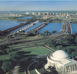 |
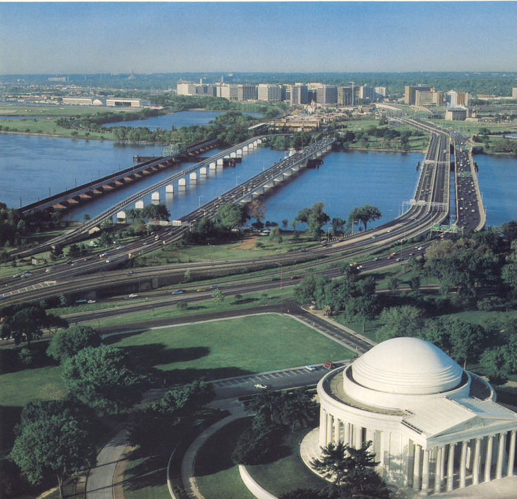
14th Street Bridge complex, looking from D.C. into Virginia, with Jefferson Memorial in foreground. From left to right, respectively, the 5 spans are railroad, WMATA Metrorail, highway northbound, highway express, and highway southbound. The series of high-rise buildings in the distance is Crystal City, and the north end of Washington National Airport is visible at the left upper part of the photo. A Yellow Line train is visible in the center of the Metrorail bridge. This photo came from the July 1983 Metro Memo Tabloid magazine, published by the Washington Metropolitan Area Transit Authority (WMATA). Click for larger photo images: Medium (58K), Large (134K), Extra Large (548K). |
Improvements were put under study in 2001 for the
14th Street Bridge. The Washington Post had the article "Improvements
Proposed for 14th St. Bridge - Plan Aims to Tackle Access, Exit Ramps", on
Sunday, July 8, 2001. Excerpt follows (blue text):
One of Northern Virginians'
greatest commuting frustrations -- the 14th Street Bridge -- is slated for improvements
under the transportation money bill working its way through Congress. If the current
bill becomes law, as is widely expected, Congress will have appropriated for the
third consecutive year a few million dollars toward the bridge, which 242,000
vehicles cross each weekday -- many of them quite slowly. "We recognize that the
14th Street Bridge just is carrying more traffic than it was ever meant to handle,"
said U.S. Rep. James P. Moran Jr. (D-Va.), who with Frank R. Wolf (R-Va.) has
pushed for the funding. "But the situation is going to be greatly exacerbated
when the Woodrow Wilson Bridge begins construction in earnest." Traffic engineers
expect many motorists to avoid Wilson Bridge construction by using Interstate
395 through the city. The full menu of possible changes, many of which could not
happen for years, include such major projects as the additions of another northbound
lane to the bridge and an acceleration or merge lane on a couple of key ramps,
as well as minor projects such as better signage. The major change to be financed
by the currentbill would be addition of a merge lane carrying traffic from the
southbound 14th Street Bridge to the northbound George Washington Memorial Parkway.
There is little merge space onto the parkway, and afternoon rush-hour traffic
backs up onto the bridge. As part of that improvement, the parkway's "humpback
bridge," just south of the Navy Merchant Marine Memorial, would be replaced with
a wider and possibly flatter bridge.
The article goes on to say that the most expensive change would be to add another lane to the four-lane northbound bridge, which would involve widening the substructure of the bridge, and that alternative would cost $72 million. However, the $23.5 million that Congress has appropriated to the bridge in the last three years, including the pending bill, could probably fix the humpback bridge, and put a new acceleration lane on the ramp carrying drivers from the southbound parkway north over the bridge, another morning choke point.
 |
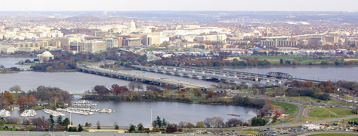
| 14th Street Bridge complex, looking from Virginia into D.C. Click for larger photo image: Large (912K). Aerial photo by Virginia Department of Transportation, November 2002, used by permission. |
Copyright © 1997-2004 by Scott Kozel. All rights reserved. Reproduction, reuse, or distribution without permission is prohibited.
By Scott M. Kozel, Roads to the Future
(Created 8-14-1997; last updated 6-20-2004)