| I-64
Widening Projects in Newport News and Hampton |
Eight-lane widening with HOV lanes, was completed in July 2006, on the 10.7
miles of I-64 from 0.5 mile west of Bland Boulevard in Newport News, to the I-664
westerly ramps with I-64 in Hampton. There were earlier I-64 widening projects
to the east of the current projects, to the Hampton Roads Bridge-Tunnel (HRBT),
and future I-64 widening projects are planned to the west of the current projects,
to Richmond. The I-64 highway and these projects are administered by the
Virginia Department of Transportation (VDOT).
The four widening projects on the 10.7 mile segment of I-64 described above, have
been completed to eight lanes, with the easternmost project completed in July
2006. In December 2001, two new HOV-2 lanes, one eastbound and one westbound,
opened on the 7.6-mile-long section of I-64 between near the Bland Boulevard overpass
and Hampton Roads Center Parkway, thus adding new 7th and 8th lanes to the new
5th and 6th lanes that were opened earlier in 2001. By July 2006, the HOV lanes
were extended to I-664. The inside lane each way on this 10.7 miles of I-64
are concurrent flow HOV (High Occupancy Vehicle) lanes that are HOV-2 during peak
morning and evening weekday hours. So three lanes each way are general purpose
lanes open to all motor vehicle traffic at all times, and the inside lane each
way is HOV-2 (each vehicle must have at least two people) during peak periods
and is open to all traffic during non-peak times.
The final 2.5-mile-long I-64 widening project between Hampton Roads Center
Parkway and I-664, the Coliseum Central Project, was placed under construction
in June 2001 and was completed in July 2006, and it included major expansion to
the US-258 Mercury Boulevard interchange, and it added one lane each way to the
I-64 highway which was formerly three lanes each way, and the new lanes are on
the inside of each roadway and have the same HOV-2 peak period restrictions as
described above. Actually, including auxiliary lanes added on the right of each
I-64 roadway, the I-64 highway has 10 lanes (5 each way) between Hampton Roads
Center Parkway and VA-134 Magruder Boulevard, 12 lanes (6 each way) between Magruder
Boulevard and US-258 Mercury Boulevard, and 10 lanes (5 each way) between Mercury
Boulevard and I-664. I-64 is a very wide highway in that segment.
All four of these projects include full 10-foot paved emergency shoulders on
the right and left sides of each roadway.
|
Interstate 64 Widening Highlights |
|
I-64 in Newport News and Hampton was originally
completed in sections, from 1957 to 1965, as a 4-lane freeway. |
|
The 6.5-mile-long section of I-64 in Hampton from
just west of VA-134 Magruder Boulevard, to VA-143 Mallory Street (just west of the
HRBT) was widened from four lanes to six lanes, built in sections from 1979
to 1988. |
|
The I-64/I-664 interchange and 1.2 miles of I-664 in Hampton was completed
and opened in 1981, and the first widening project on I-64 of one mile in the
I-664 interchange area was part of that project. |
|
The 4.0-mile-long I-64 section from 0.3 mile east of US-17 J Clyde Morris
Boulevard, to 0.4 mile east of Hampton Roads Center Parkway (HRCP), was widened from
four lanes to six lanes in two projects. The 2.0 miles from west of Hampton
Roads Center Parkway to Magruder Boulevard was completed in 1990; and the 2.0
miles from east of US-17 to mile west of HRCP was completed in 1995. |
|
On the 10.7 miles of I-64 from Bland Boulevard to I-664 -- the current 8
lane widening program was conceived in mid-1980s. The widened highway has
three general purpose lanes each way, and a fourth inner lane each way for
High Occupancy Vehicles (HOV-2) during peak hours and open to all vehicles
during non-peak hours. |
|
On the 10.7-mile widening program -- 8-laning was completed on 7.6-mile-long
section of I-64 from 0.5 mile west of Bland Boulevard overpass, to 0.4 mile
east of Hampton Roads Center Parkway, on December 17, 2001, at a cost of $102.8
million. |
|
On the 10.7-mile widening program -- The final 2.5-mile-long I-64 widening
project from Hampton Roads Center Parkway to I-664, the Coliseum Central Project,
was completed in July 2006, at a construction cost of $106.4 million. |
|
As of July 2006, the 10.7 mile I-64 widening program is completed, at a
total cost of $283.2 million, for the whole program for engineering,
right-of-way and construction. |
|
A new I-64 interchange is being planned at Bland Boulevard near the Williamsburg -
Newport News International Airport. The cost is estimated at $70 to $80
million for engineering, right-of-way and construction, but the construction
is not scheduled in the FY2005-06 VDOT Six Year Improvement Program. |
|
Preliminary engineering is underway for 6- and 8-lane widening on I-64 west
of the current Newport News projects, all the way to VA-156 Airport Drive in
the Richmond area (I-64 is currently 6 lanes between I-95 in downtown Richmond
and VA-156). |
|
The current tentative plan is to widen I-64 to 8 lanes, from the current
western limit of 8-lane widening near the Bland Boulevard overpass area, to
VA-199 east of Williamsburg; to widen I-64 to 6 lanes between VA-199 and
VA-249 at Bottoms Bridge in New Kent County, to widen I-64 to 8 lanes
between VA-249 and I-295, and to widen I-64 to 6 lanes between I-295 and
VA-156 Airport Drive. Construction is not scheduled on any of these projects
in the FY2005-06 VDOT Six Year Improvement Program. |
The following 3 photos were taken by Roads
to the Future in early March 2002.
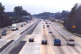 |
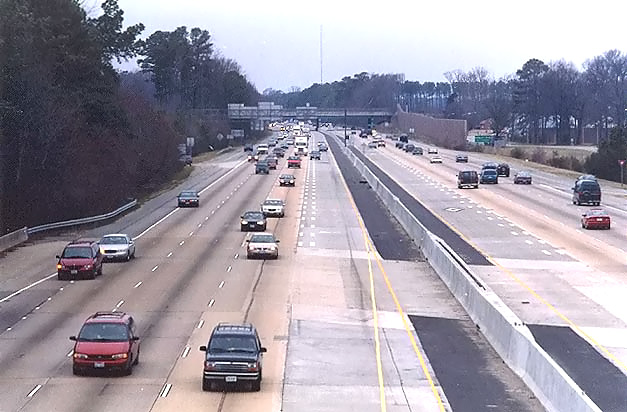
I-64 in Hampton,
looking westward from the Hampton Roads Center Parkway (HRCP) overpass. The
lane that was added, is the HOV inside lane each way, and it is 16 feet wide
to allow for the 4-foot double-line separator between that lane and the adjacent
lane. The rest of the lanes are 12 feet wide, the standard lane width for
Interstate highways. |
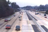 |
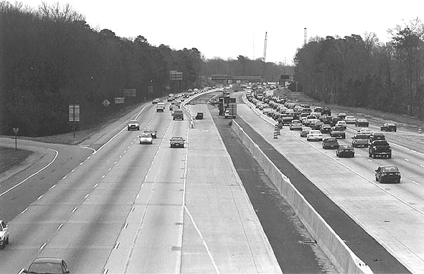
I-64 in Hampton,
looking westward from the Hampton Roads Center Parkway overpass. Similar vantage
point as previous photo, taken a few minutes later on the same day, but about
50 feet to the left. On the eastbound roadway, the HOV inner lane temporarily
ended in the foreground of the photo; the HOV widening project from
there to I-664 is under construction (and was completed in July 2006 with
all lanes opened). |
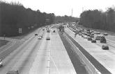 |
I-64 in Hampton,
looking eastward from the Hampton Roads Center Parkway overpass. The previously
constructed project ended up ahead where you can see the concrete inner lanes
ending, and the Coliseum Central Project then under construction can be seen
starting at that point and proceeding eastward. The partially demolished Magruder
Boulevard overpass can be seen in the distance; the widening necessitated
the complete replacement of that bridge, and a construction detour utilized
westbound HRCP and eastbound I-64. Photo taken about 10 minutes after the
previous two photos. It was a color photo, but it was dark enough that the
HP ScanJet 5300 translated it into black-and-white. |
The following 16 photos were taken on September
28, 2006, by the Virginia Department of Transportation, and are posted here with
their permission. Roads to the Future utilized PhotoDeluxe Business
Edition to sharpen and brighten and to align all of the photos. Click on the photo
to get a large version of the photo. In later versions of Netscape and Internet
Explorer, you probably will need to use Full Screen mode (the F11 key can be utilized
to swap back and forth between Full Screen and Regular) to see the full size of
the large photo without browser-induced image shrinkage. The large photos have
sizes ranging from 156 to 230 kilobytes, with most of them being under 181 kilobytes.
With a broadband or network Internet connection each photo will download within
seconds, but with a dial-up Internet connection it will be somewhat slower.
 |
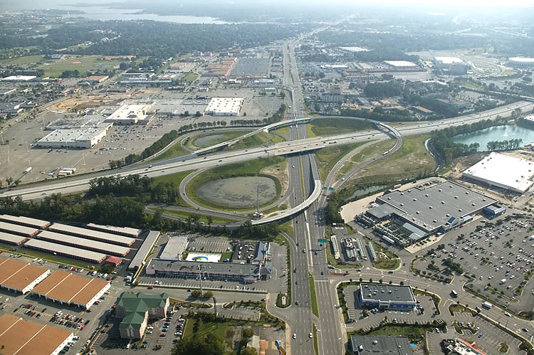
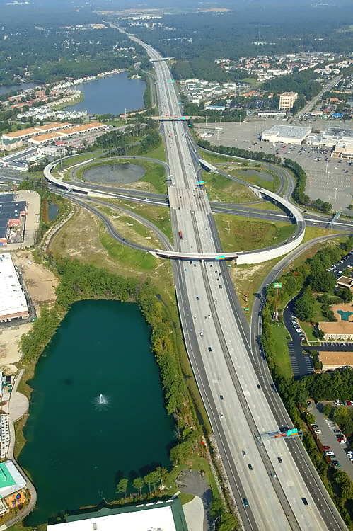
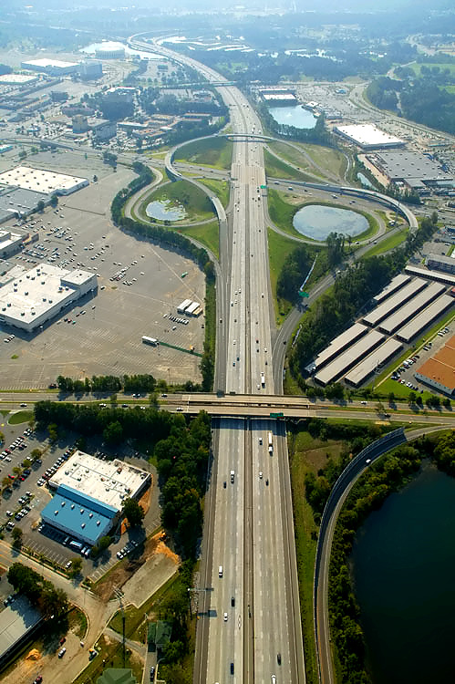
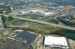
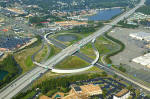
Reconstructed interchange of I-64 and US-258 Mercury
Boulevard in Hampton, looking eastward. Mercury Boulevard runs bottom to top,
and is a 6- to 8-lane arterial. I-64 runs left to right, and is 10 to 12 lanes
wide between I-664 and Magruder Boulevard. The rebuilt interchange has 4 outer
ramps, 2 loop ramps, and 2 semi-directional ramps (the original
interchange had 4 outer ramps and 4 loop ramps). The semi-directional ramps,
also referred to as "flyover ramps", handle the movement from eastbound Mercury
Boulevard to westbound I-64, and the movement from eastbound I-64 to eastbound
Mercury Boulevard. Traffic volumes at this junction in 2005, averaged about 138,000
vehicles per day on I-64, and about 66,000 vehicles per day on Mercury Boulevard.
Peak summer weekend day traffic on I-64 can reach about 170,000 vehicles per
day. |
 |
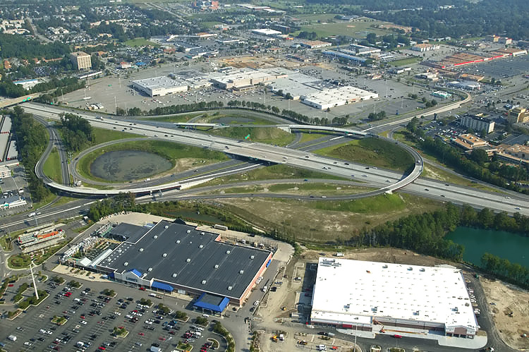
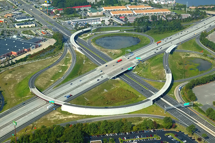
Reconstructed
interchange of I-64 and Mercury Boulevard, looking northeast. Mercury
Boulevard runs lower left to upper right, and I-64 runs upper left to lower
right. |
 |
Reconstructed
interchange of I-64 and Mercury Boulevard, looking northwest. Mercury
Boulevard runs left to right, and I-64 runs bottom to top. |
 |
Reconstructed
interchange of I-64 and Mercury Boulevard, looking west. Mercury
Boulevard runs upper left to lower right, and I-64 runs lower left to upper
right. |
 |
Reconstructed
interchange of I-64 and US-258 Mercury Boulevard in Hampton, looking west.
Mercury Boulevard runs upper left to lower right, and I-64 runs lower left
to upper right. |
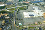 |
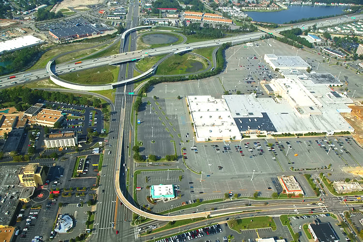
Reconstructed
interchange of I-64 and Mercury Boulevard, looking west. Mercury
Boulevard runs bottom to top, and I-64 runs left to right. Mercury Boulevard
has a flyover ramp into the shopping mall access road, and that ramp was built
over 20 years ago. The shopping mall in the right of the photo, is the Coliseum
Mall. |
 |
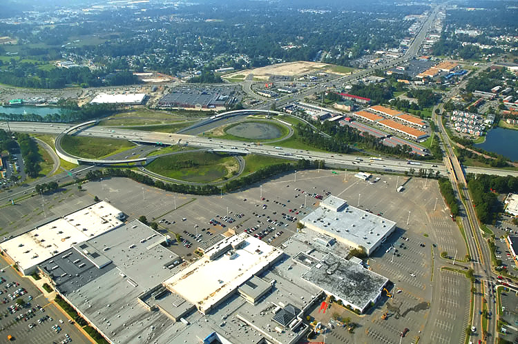
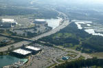
Reconstructed
interchange of I-64 and Mercury Boulevard, looking southwest. Mercury
Boulevard runs center left to upper right, and I-64 runs left to right. The
shopping mall in the bottom of the photo, is the Coliseum Mall. Cunningham
Drive is a 4-lane arterial, and crosses over I-64 in the right of the photo. |
 |
Reconstructed
interchange of I-64 and Mercury Boulevard, looking southeast. Mercury
Boulevard runs left to right, and is a 6- to 8-lane arterial. I-64 runs bottom
to top, and is 10 to 12 lanes wide between I-664 and Magruder Boulevard.
Cunningham Drive is a 4-lane arterial, and crosses over I-64 in the lower
part of the photo. |
 |
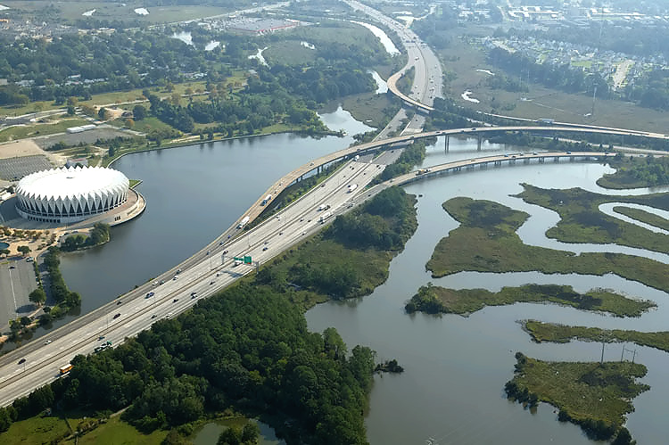
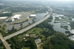
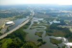
I-64 runs lower left to upper center, and I-664
runs to the right. Looking east. Interchange of I-64 and I-664 is in the distance.
The Hampton
Coliseum is visible in the left of the photo. |
 |
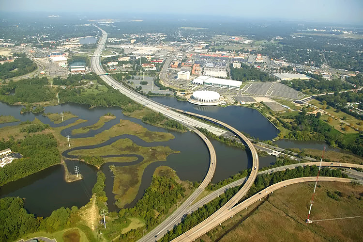
I-64 runs
lower left to upper center, and I-664 runs to the right. Looking east. Interchange
of I-64 and I-664 is in the distance. |
 |
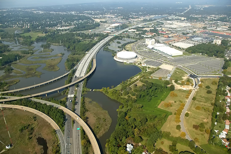
I-64 runs lower left to upper center, and I-664
runs to the right. Looking east. The
Hampton
Coliseum is visible in the left of the photo. The 3-leg I-64/I-664 interchange
is a semi-directional interchange with high-speed 2-lane ramps connecting
the two highways. This section of I-64 originally opened in 1957, and the
I-64/I-664 interchange and 1.2 miles of I-664 in Hampton was completed and
opened to traffic in 1981. Much of the length of the I-64/I-664 interchange
ramps was bridged over water and marshlands, rather than on earthen fill as
on the mainline of I-64, due to the higher environmental protection standards
that existed subsequent to the National Environmental Protection Act of 1969
(NEPA). |
 |
I-64 runs
lower left to upper center, and I-664 runs to the right. Looking east. Interchange
of I-64 and I-664 is in the distance. |
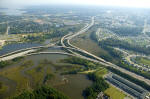 |
I-64 runs center left to upper center, and I-664
runs to the lower right. Looking east. The 3-leg I-64/I-664 interchange is a semi-directional
interchange with high-speed 2-lane ramps connecting the two highways. I-64
has 10 lanes (5 each way) between I-664 and Mercury Boulevard, and I-64 has
6 lanes (3 each way) between I-664 and 1/2 mile west of the I-64 Hampton Roads
Bridge Tunnel (which has 4 lanes, or 2 each way), and I-664 in Hampton has 6 lanes
(3 each way). |
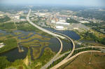 |
I-64 runs
upper left to lower right, and I-664 runs to the bottom. Looking northwest.
The I-64/I-664 interchange is in the foreground. |
 |
I-64 runs
bottom to top, and I-664 runs to the left. Looking west. The I-64/I-664 interchange
is in the center. |
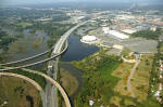 |
I-64 runs
bottom to top, and I-664 runs to the left. Looking west. The I-64/I-664 interchange
is in the lower left, and Hampton Coliseum is in the center. |
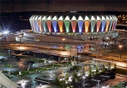 |
Each Christmas season, the
Hampton
Coliseum gets bathed in bright festive colors.
|
Virginia HOV Lane Systems
The Peninsula is the third region in Virginia to get HOV lanes, after Northern
Virginia (1969) and South Hampton Roads (1992). The Peninsula HOV lanes are designated
as HOV-2 lanes for vehicles carrying two or more people, as well as buses,
motorcycles and emergency vehicles. "The Peninsula" is the regional name for the
peninsular segment of land between the James River, the York River, and
Chesapeake Bay, and it
includes the areas of Hampton, Newport News, Williamsburg, York County and part
of James City County. Due to the high directional split of peak traffic, the HOV lanes
in Northern Virginia and in South Hampton Roads, operate in a single peak period
direction. On the Peninsula, the HOV hours of operation are from 6 a.m. to 8 a.m. and 4 p.m. to 6 p.m.
in both directions, Monday through Friday. After analyzing traffic volumes and
patterns, VDOT determined that the HOV hours of operation apply in both directions
during both peak periods due to the approximately equal distribution of traffic
eastbound and westbound. The HOV lanes are open to all motorists during all other
hours of the day and on weekends. Similar to the HOV lanes on I-264 in Norfolk
and Virginia Beach, these lanes are not barrier separated, allowing motorists
to easily merge on and off the lanes at any time.
Recent I-64 Widening Projects in Newport News and Hampton
Regarding the initial opening of the HOV lanes on the Peninsula, in VDOT's
news release "Peninsula HOV Lanes on I-64 to Open Monday", December 12, 2001,
VDOT wrote (excerpt in blue text):
Nearly seven miles of High
Occupancy Vehicle (HOV) lanes along I-64 on the Peninsula are scheduled to open
on Monday, December 17. The two new lanes, one eastbound and one westbound, add
capacity to I-64. The lanes stretch from an area near the Bland Boulevard overpass/Jefferson
Avenue to Hampton Roads Center Parkway. The opening of this segment of lanes marks
the first phase in a 22-mile stretch of HOV lanes planned for the Peninsula.
A set of I-64 widening projects in Newport News, was completed in
December 2001. The total mainline length was 4.2 miles, from 0.5 mile west of
Bland Boulevard to 0.3 mile east of US-17 J Clyde Morris Boulevard, and the cost
for engineering, right-of-way and construction, was $87.2 million. The existing
four-lane (two each way) Interstate highway was widened to eight lanes (four each
way), with replacement of existing pavement and existing mainline bridges. The
existing interchanges at VA-143 Jefferson Avenue and US-17 J Clyde Morris Boulevard
were upgraded. A concrete median barrier was installed. Collector-distributor
roadways were added at the VA-143 Jefferson Avenue interchange. One new lane each
way was opened in June 2001, making the highway six lanes (three each way). The
fourth lane each way opened on December 17, 2001, as an HOV-2 lane.
The plan since these projects were conceived in the mid-1980s, had been to
widen to eight lanes the 10.7 miles of I-64, from 1/2 mile west of Bland Boulevard
in Newport News, to the I-664 interchange in Hampton, with three general purpose
lanes each way and a fourth inner lane each way for HOV (High Occupancy Vehicles)
during peak hours.
The 2.7 miles of four-lane I-64 from 0.9 mile east of VA-143 Jefferson Avenue
to 0.3 mile east of US-17 J Clyde Morris Boulevard, was widened to eight lanes
with a 22-foot-wide grass median, with completion in early 1999, with six lanes
open to traffic and the inner lane each way striped off as closed. The inner shoulders
were built as grassed earth. The two projects on this section cost $36.8 million
for engineering, right-of-way and construction. [2]
The project completed in 2001 involved widening 1.5 miles of I-64 four-lane
highway to eight lanes, from 0.5 mile west of Bland Boulevard to 0.9 mile east
of VA-143 Jefferson Avenue. It also performed the interchange improvements at
VA-143 Jefferson Avenue and US-17 J Clyde Morris Boulevard. It also paved the
median and installed a concrete median barrier on the 2.7-mile section mentioned
in the previous paragraph. This project cost $50.4 million for engineering, right-of-way
and construction. [1]
The 10.7 miles of I-64 from 0.5 mile west of Bland Boulevard in Newport News
to I-664 in Hampton, as of June 2001, had six mainline lanes open throughout (and
the rest of I-64 from I-664 to near the Hampton Roads Bridge-Tunnel [HRBT] was
six lanes too). The 4.2 miles discussed above had eight lanes with the inner lane
each way initially closed as said. The 6.5 miles between there and I-664 had six
lanes, and a 4.0 mile long project from 0.3 mile east of US-17 J Clyde Morris
Boulevard to 0.4 mile east of Hampton Roads Center Parkway, was begun in 1999
to widen the highway to eight lanes, with completion occurring in December 2001
at a cost is $15.6 million for engineering, right-of-way and construction. [3]
That project joins the eight lane section just west of there, leaving only one
project left in the program to make the entire 10.7 mile section of I-64 eight
lanes wide. Those western 7.6 miles had the fourth lane each way opened on December
17, 2001. The final project widened 2.5 miles of six-lane highway to eight lanes,
from 0.4 mile east of Hampton Roads Center Parkway to the I-664 westerly ramps
with I-64; and it was placed under construction in June 2001, and was completed
in July 2006, with a total cost of $106.5 million for construction. The final
project included a major upgrade to the full cloverleaf interchange of I-64 and
US-258 Mercury Boulevard, which included two new semi-directional flyover ramps. [4]
In July 2006, the 10.7-mile-long I-64 widening
program reached completion, at a total cost of $283.2 million, for the whole program
for engineering, right-of-way and construction, which is an average cost of $26.5
million per mile. This includes the aforementioned expansions to five interchanges
and all associated work on connecting roads. The funding type was National Highway
System / Interstate Maintenance, which is comprised of 90% federal funds from
the Federal Highway Administration (FHWA) Highway Trust Fund and 10% state funds from VDOT.
As cited in other Roads to the Future articles, freeway HOV lanes
not only provide fast travel for car pools and van pools during peak hours, but
also provide an open uncongested lane for express bus mass transit. The HOV
person occupancy threshold can be increased in the future if the lane at the existing
threshold becomes congested, and the time span of HOV operation can be increased
if the peak hours expand and begin to congest these lanes during bordering time
periods currently outside of the HOV restrictions.
Summary of Recent I-64 Widening Projects
Again, as outlined above, these are the project sections of the 10.7 miles
of I-64 eight-lane widening that was completed in July 2006, from west of Bland Boulevard in Newport News, to the
I-664 interchange in Hampton. The sections are listed in sequence from west to
east, with footnote references to text above ---
[1] 1.5 miles, from 0.5 mile west of Bland Boulevard, to 0.9 mile east of VA-143
Jefferson Avenue
[2] 2.7 miles, from 0.9 mile east of VA-143
Jefferson Avenue, to 0.3 mile east of US-17 J Clyde Morris Boulevard
[3] 4.0 miles, from 0.3 mile east of US-17
J Clyde Morris Boulevard, to 0.4 mile east of Hampton Roads Center Parkway
[4] 2.5 miles, from 0.4 mile east of Hampton
Roads Center Parkway, to the I-664 westerly ramps with I-64
Here are images (large and small) of a section of the VDOT 2002 state map where
Roads to the Future has shown with a red pen the limits and number
of each section as described above, with #1, #2, and #3 and #4 shown.
Small Map
(123K)
Large Map
(262K)
Past I-64 Widening Projects in Hampton
The 4.0-mile-long section from 0.3 mile east of US-17 J Clyde Morris Boulevard
to 0.4 mile east of Hampton Roads Center Parkway, was widened from four lanes
to six lanes in two projects. The 2.0 miles from west of Hampton Roads Center
Parkway (the HRCP/I-64 interchange was built then) to Magruder Boulevard was completed
in 1990; and the 2.0 miles from east of US-17 to west of HRCP was completed in
1995. [3] Since this was part of the 10.7 miles that was planned to be eight-laned
since the mid-1980s, Roads to the Future doesn't know why these projects weren't eight-laned -- as
mentioned above, that very section was widened from six lanes to eight
lanes, with completion in December 2001. It is true that the fourth lane each
way would not have been initially usable since the planned eight-lane projects
west and east of there had not been started, but the fourth lanes could have been
initially striped as closed as was done on the more recent projects west of there.
Hampton Roads Center Parkway (HRCP) is a 4-lane limited access highway that
extends 5.0 miles from US-17 Jefferson Avenue in Newport News to Armistead Avenue
in Hampton. The 2.8 miles of the Hampton Roads Center Parkway from Big Bethel
Road to Armistead Avenue was completed when the I-64/HRCP interchange was completed in 1995. The 2.2-mile last section of Hampton Roads Center Parkway was
completed in Newport News in January 2003, and it extended the 4-lane parkway westward
to US-17 Jefferson Avenue. Actually, a 6-lane widening of one mile of Harpersville
Road was utilized to carry the westernmost mile of the parkway to Jefferson Avenue.
HRCP has a continuous roadway connection with Harpersville Road. The planning
name for the Hampton Roads Center Parkway was the East-West Expressway, with plans
to extend it as far west as US-17 Jefferson Avenue and Harpersville Road, and
as far east as VA-169 Fox Hill Road in Hampton (the 4-mile-long unbuilt HRCP segment
east of Armistead Avenue is not programmed
in the FY2005-06 VDOT Six Year Improvement Program, and it faces major environmental
obstacles due to wetlands).
The 6.5-mile-long section of I-64 in Hampton from just west of Magruder Boulevard
to VA-143 Mallory Street (just west of the Hampton Roads Bridge-Tunnel) was widened
from four lanes to six lanes much earlier, constructed in sections from 1979 to
1988. This widening included building a parallel 3-lane bridge over the Hampton River for
westbound I-64 mainline traffic, rebuilding the pre-existing 4-lane bridges over
the Hampton River for 3-lane eastbound I-64 mainline traffic, the realignment
and straightening of 1/2 mile of mainline I-64 in the VA-143 Mallory Street interchange
area to remove two sharp 45 mph curves, and other interchange improvements. The
first of these widening projects was the one mile of I-64 that was widened in
conjunction with the construction of the I-664 interchange built 1979-1981. The
I-64/I-664 interchange and 1.2 miles of I-664 in Hampton was completed and opened
on June 25, 1981, and the first widening project on I-64 of one mile in the I-664
interchange area was part of that project. That section of I-664 was also the
first segment of I-664 to be built. The last segment of I-64 to be widened in
this program was at the Hampton River, which was completed in 1988. The existing traffic volumes on I-64 and the
volumes projected on I-64 due the ultimate completion of I-664, were the reason
for the widening program on the section of I-64 from Magruder Boulevard to VA-143
Mallory Street.
The I-64 toll plaza for the HRBT was just east of Mallory Street, and it was
removed when the HRBT became toll-free in 1976.
Future I-64 Widening Projects between Newport News and Richmond
A new I-64 interchange is being planned at Bland Boulevard near the
Williamsburg - Newport News
International Airport. One of the designs considered is a SPUI (Single Point
Urban Interchange). This new interchange and its connecting roads will provide
better local access to/from I-64 as well as direct I-64 access to/from the airport,
which is seeing continual growth in airline traffic. The cost is estimated at
$70 to $80 million for engineering, right-of-way and construction, but the construction
is not scheduled in the FY2005-06 VDOT Six Year Improvement Program.
Preliminary engineering is underway for widening on I-64 west of the current
Newport News projects, all the way to VA-156 Airport Drive in the Richmond area,
since this highway has begun experiencing significant peak-period congestion in
the last few years, and traffic volumes continue to grow. All of the current I-64
highway on that stretch is four lanes (two each way) and some of the widened sections
will be six lanes (three each way) and some will be eight lanes (four each
way).
The current tentative plan is to widen the I-64 highway to eight lanes (four
each way) from the current western limit of eight-lane widening near the Bland
Boulevard overpass area in Newport News, to VA-199 Humelsine Parkway east of Williamsburg
(the eastern I-64/VA-199 interchange, I-64 Exit 242), with a similar configuration
to the recently widened highway, with three general purpose lanes each way and
a fourth inner lane each way for HOV-2 during peak hours. No I-64 HOV lanes are
planned west of the eastern I-64/VA-199 interchange. The current tentative plan
is to widen I-64 to 6 lanes between VA-199 east of Williamsburg, and VA-249 at
Bottoms Bridge in New Kent County; to widen I-64 to 8 lanes between VA-249 and
I-295 in Henrico County, and to widen I-64 to 6 lanes between I-295 and VA-156
Airport Drive. Construction is not scheduled on any of these projects in the FY2005-06
VDOT Six Year Improvement Program. I-64 is currently 6 lanes between I-95 in downtown
Richmond and VA-156.
I-64 Traffic Volumes and Original Openings
The I-64 traffic volume just east of the I-95 downtown interchange is about 94,000 AADT
(annual average daily traffic) with 5% large trucks. Eastward, the volumes decrease, with
58,000 just east
of Nine Mile Road, 56,000 just east of VA-156 Airport Drive, and 68,000
just east of I-295.
The 38-mile-long section from I-295 to VA-143 Camp Peary Road at Williamsburg
varies from 47,000 to 68,000 with 8% large trucks, with the lowest volume being
in the area near Norge. Traffic volumes increase eastward on the 30-mile-long
stretch to the HRBT, with 80,000 AADT at the Newport News/James City Co. border,
113,000 just east of VA-143 Jefferson Avenue, 120,000 to 146,000 between US-17 J Clyde Morris
Boulevard and I-664, and 91,000 AADT and 4% large trucks across the
3.5-mile-long HRBT. See Roads to the Future article
Interstate 64 in Virginia. Traffic volumes from
Average Daily Traffic Volumes with Vehicle Classification Data on Interstate,
Arterial and Primary Routes , by VDOT, 2005.
The first section of I-64 in Virginia to open to traffic was in November 1957
with the 6-mile-long section in Hampton from Magruder Boulevard to the Hampton
Roads Bridge-Tunnel (HRBT), and the first 2-lane HRBT opened then too. The 7 miles
from Magruder Boulevard to VA-143 Jefferson Avenue in Newport News opened in two
sections in 1959 and 1960. The 18-mile-long section from VA-143 Camp Peary Road
north of Williamsburg to VA-143 Jefferson Avenue near Williamsburg-Newport News
International Airport, opened in 1965.
Links to VDOT's Website on I-64 Widening Projects
I-64 Widening Projects on the Peninsula
(Excerpt in blue text):
The Major Investment Study (MIS) has
been concluded and a Locally Preferred Alternative (LPA) was decided on. The LPA
for I-64 included three (3) Lanes and one (1) concurrent High Occupancy Vehicle
(HOV) lane in each direction from I-664 to Route 199 near Grove (Exit 242). It
also recommended three (3) lanes in each direction from Route 199 (Exit 242) to
the New Kent/James City County Line. [...] At this time a feasibility study is
underway on an additional interchange at the current Bland Boulevard crossing.
A public Information Meeting was held in April 2002.
Coliseum Central Highway Project - Interstate I-64 between the I-664 split
and the Hampton Roads Center Parkway.
High
Occupancy Vehicle (HOV) Systems - VDOT webpage for detailed information about
the HOV lane systems in Virginia. The webpage has a link to
HOV
- Hampton Roads: Maps.
I-64 Pavement Improvement Project - Road Surface Improvement on the Peninsula.
Hampton Roads
Transit - Traffix Program - HOV information for the Norfolk/Hampton Roads
area. TRAFFIX is a cooperative public service designed to promote transportation
alternatives. Its objective is to decrease traffic congestion in Southeastern
Virginia by reducing the number of Single Occupancy Vehicles (SOVs) commuting
to work sites. TRAFFIX is active on two levels, working with both employers and
employees.
HOV Lanes
with maps of the HOV System.
Sources
Virginia Department of
Transportation (VDOT) , VDOT FY2005-2006 Six-Year Improvement Program, VDOT FY2000-2001 Six-Year Improvement
Program, VDOT FY1998-1999 Six-Year Improvement Program, VDOT FY1995-1996 Six-Year
Improvement Program, VDOT FY1990-1991 Six-Year Improvement Program. Average
Daily Traffic Volumes with Vehicle Classification Data on Interstate, Arterial
and Primary Routes, by Virginia Department of Transportation, 2005. Also, VDOT website and Hampton Roads Daily Press.
Copyright © 2001-2006 by Scott Kozel. All rights reserved. Reproduction, reuse,
or distribution without permission is prohibited.
Back to top
By Scott M. Kozel, Roads to the Future
(Created 3-31-2001, updated 12-1-2006)