
| New River Gorge Bridge (US-19 Corridor "L") |
The US-19 New River Gorge Bridge was completed near Fayetteville, West Virginia on October 22, 1977, and this completed the last link in Appalachian Corridor "L".
This article relies mostly on other websites, and I'll post a series of links with excerpted information here. These are fine websites with lots of good information and photos.
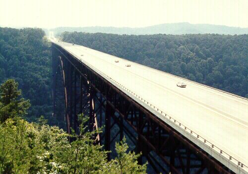
Above, looking south from overlook. By Scott Kozel
in 1991.
From New River Gorge Bridge,
by the National Park Service (excerpt in blue text):
Arching gracefully across the
New River, the bridge has the world's longest single arch steel span. At 876 feet
above the New River, it is the second highest bridge in this country. Only the
Royal Gorge Bridge over the Arkansas River in Colorado is higher. [...] The West
Virginia Department of Highways, which owns the bridge, chose the Michael Baker
Company to do the design. The construction contract was awarded to the American
Bridge Division of U.S. Steel.
The New River Gorge Bridge, by Adam Prince. Photos and information.
New River Gorge Bridge, by Rich Koors of Virginia Tech. He has details on the design, construction, maintenance of the bridge, plus photos. Under "Design", he shows different concepts that were studied during design, including a suspension span. Under "Construction", he shows details of how it was constructed.
Bridge statistics:
Height -------------------- 876 ft.
Bridge Length ----------- 3,030 ft.
Arch Length ------------- 1,700 ft.
Rise ---------------------- 360 ft.
Final Cost -------- $37,000,000
Bid Price --------- $33,984,000
Weight ------------- 88,000,000 lbs.
- Steel ------------ 44,000,000 lbs.
- Concrete --------- 44,000,000 lbs.
- Heaviest Piece ------ 184,000 lbs.
- Arch ------------- 21,066,000 lbs.
Deck Width ------------- 69-1/3 ft.
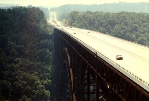
Above, same shot as above, with telephoto.
New River Gorge Bridge Day Festival, by West Virginia Outside. This has details about the Saturday, October 21, 2000 event. BASE jumping is allowed on Bridge Day (BASE stands for "building, antenna, span and earth." This refers to stationary objects from which skydivers jump). More on BASE jumping. Still more on BASE jumping.
Also see Bridge Day Association for more photos and information. Here's some nice photos of the New River Gorge Bridge. David Denenberg has another fine picture of the New River Gorge Bridge. From itsthatsimple.com, more information about Bridge Day.
Songer Whitewater Rafting page on the New River Gorge. Mountain Bike West Virginia page on the New River Gorge Trail. By Dick Chambers, New River Gorge Photos. New River Gorge National River by the National Park Service, with many links. Information on West Virginia Whitewater Rafting.
Specialty
Groups Inc. has a web page about its
project to clean the bridge
(use buttons "How", "Why", "Media, and "Contract") (excerpt in blue text):
The New River Gorge Bridge
is the world's largest single span arch bridge and the United States second tallest
bridge. It is constructed of weathering steel, a steel designed to protect itself
with a coating of its own rust, preventing continued corrosion. This concept is
good in theory but has problems that occur in certain areas on structures that
utilize this steel. Basically, areas that are affected are areas where water continuously
lays and where drainage water is focused over an area of the steel resulting in
continued rusting.
Building Big Databank by PBS - New River Gorge Bridge.
In 2002, the
American Road & Transportation Builders Association (ARTBA) had an article
New River
Gorge Bridge & Interstate Highway System Selected West Virginia's Top Transportation
Infrastructure Projects of 20th Century.
Excerpts (blue text):
The New River
Gorge Bridge is a vital component of West Virginia's highway network and a spectacular,
popular attraction for visitors. Recognized for its engineering achievements,
the bridge soars 876 feet above the scenic New River and is the longest single
arch steel span in the world and the second highest bridge in the United States.
Completed in 1977 at a cost of $37 million, the bridge is part of the Appalachian Highway System's Corridor "L" (U.S. 19). It provides a north-south link from I-79 in the center of the state to the West Virginia Turnpike, I-64 and I-77 near Beckley and carries an average of 17,000 vehicles daily. The construction of the bridge shortened a forty-minute drive down winding mountain roads to less than a minute.
The Appalachian
Regional Commission has an article about
Corridor "L", "West Virginia's
Corridor L Opens the Door to Tourists", by James E. Casto, 1996. Excerpts
below (blue text):
U.S. 19 - Appalachian
Corridor L - is a 70-mile north/south shortcut from Interstate 79 near Sutton
to the West Virginia Turnpike just north of Beckley. Along the way it cuts across
the spectacular New River Gorge and the historic Midland Trail (U.S. 60), the
winding east/west route first authorized in 1790 as a state road by the Virginia
Assembly.
Construction of Corridor L was started in 1969 and completed in 1978 at a cost of $174 million in state and federal funds. More than $45 million of that went to build the spectacular New River Gorge Bridge, the highest east of the Mississippi.
Based on traffic estimates at the time, only about half of Corridor L was built as a four-lane divided highway. The rest was two lanes, with a third lane provided for big trucks and other slow-moving vehicles on the steepest grades. What happened once the new road was opened surprised even those who had long campaigned for its construction. Traffic on it soared, quickly outpacing all official predictions.
Long-distance travelers also flocked to the road, finding it a handy shortcut. By turning off I-79 and driving south on Corridor L to the West Virginia Turnpike, southbound drivers found they could save about 45 minutes over continuing on to Charleston on I-79, then heading down the Turnpike. The shortcut quickly became popular with truckers and Canadian vacationers making their way from Toronto to the beaches of South Carolina and Florida.
From 1979 to 1994, the traffic count on Corridor L jumped nearly fourfold - from a daily average of 2,800 cars and trucks to more than 10,000. At some points, the count is even higher. And the Department of Transportation now expects it to double to 20,000 vehicles per day over the next 20 years.
Projects were designed and constructed to upgrade the 2-lane sections to 4-lanes divided. The final 24 miles from Summersville north to I-79, cost $168 million and moved 12 million cubic meters of earth and rock, built eight new bridges, and added two new interchanges, one for WV-82 at Birch River and the other for WV-55 at Muddlety. The widening was completed in 1998, and all 39 miles of 4-lane widening cost $287 million in state and federal funds. Added to the cost of the original Corridor "L" constructed between 1969 and 1978, that's a total of $461 million for both stages.
All photos taken by Scott Kozel unless otherwise noted.
Copyright © 2000-2002 by Scott Kozel. All rights reserved. Reproduction, reuse, or distribution without permission is prohibited.
By Scott M. Kozel, Roads to the Future
(Created 8-26-2000, updated 10-12-2002, minor updates 5-3-2003)