
| US-17 Relocation in City of Chesapeake |
The Route US-17 relocation in the City of Chesapeake, Virginia, is a 11.6-mile-long highway project that was begun in March 2003, and opened to traffic on Friday, November 4, 2005. All construction on the project was completed by January, 2006. It traverses from the North Carolina state line to Dominion Boulevard. The project was administered by the Virginia Department of Transportation (VDOT). The original US-17 was a 2-lane highway that was built in the 1930s, just barely above the low-lying terrain, with lane widths and shoulder widths that were substandard by modern standards for a major rural arterial highway. In 2001, this segment of US-17 carried about 10,000 vehicles daily with volumes projected to increase to 19,400 by 2020.
The pre-existing US-17 roadway on the southernmost 1.3 miles of the project was reconstructed to modern standards, to become the 2-lane southbound roadway, and a new northbound 2-lane roadway was built. The remaining 10.3 miles of the project is on a new location 4-lane alignment, to the east of the pre-existing US-17 highway. The median width is 42 feet, the traffic lanes are 12 feet wide, the paved right shoulders are 8 feet wide, and the paved left shoulders are 4 feet wide. Clear roadsides are typically 20 wide or wider. The highway is elevated 8 feet above the existing low-lying terrain. The highway is on a limited access right-of-way. (Source: the VDOT design plans for the project).
The prime construction contractor on the project was Barnhill Contracting Company, and the construction contract cost $41.96 million.
The contract bid amount was well below the engineering estimate for the project,
and that provided a benefit to VDOT and the taxpayers. As of the December 2002
bid opening, the VDOT Six-Year Program entry for that project was $76.566 million
programmed for Construction. There were 8 bids distributed between $41,039,684.75
(Barnhill) and $46,929,719.80. For 11.6 miles of mostly new-location four-lane
highway at a cost of $41.96 million, that works out to an average per mile
cost of $3.62
million. The project has two bridges, twin bridges over wetlands, each
984 feet long. Sometimes the state of the national economy is such that contractors
are hungry for work and will bid much lower on a project than ordinarily. That
was a very good deal for that amount of highway construction, and the quality
of work is very good. The 2006 Six-Year Program entry for this project shows expenditures
of $3.46 million for Preliminary Engineering, and $12.338 million for Right-of-Way
acquisition. Total costs for the project amount to $57.758 million.
Most of the length of the new highway was constructed about 1,000 yards east of
the old road location in order to limit disturbance to the
Great Dismal Swamp
Wildlife Refuge and surrounding forests and wetlands.
As part of this project, VDOT donated 758 acres of existing wetlands to the
Virginia
Department of Game and Inland Fisheries as wetland preservation. In addition to
the wetlands donation, VDOT purchased about 16 acres of mineral soil wetlands,
and is created about 9.6 acres of forested, organic soil wetlands within the project
corridor.
Wildlife passages are included throughout the highway. One benefit to the passages
is they allow animals to go under the new highway along the Northwest River. Passageways
are provided underneath the elevated portion of US-17 to promote bear migration.
Drainage pipes placed under parts of the new road will allow smaller animals to
migrate, while special chain-link fences guide the wildlife to the designated
crossings.
There are six public road access intersections with the relocated US-17, at Ballahack
Road, Glencoe Street, Douglas Road, Cornland Road, Business US-17, and Dominion
Boulevard. There are three private access points for a large farm that the highway
passes through on the southern part of the project, with paved crossovers. The
highway is on a limited access right-of-way, and the above 9 points are the only
breaks in the right-of-way fence.
The original section of 2-lane US-17 that was bypassed by this project, had the US-17
designation removed when the new US-17 highway opened to traffic, and the old highway
was closed to motor vehicular traffic along nearly all of its length, a couple
months after the new highway opened to traffic. A few short segments of the old
highway remain open to motor vehicular traffic, for local access to property and
recreational areas along the Dismal Swamp Canal. All of that section of former
US-17 has been designated as a multi-use trail for bicycles and pedestrians, and
it is a very nice addition to the regional system of such trails.
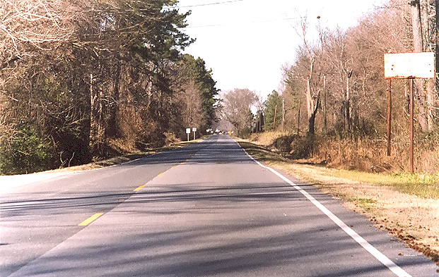 |
The original 2-lane US-17, near the north end of the US-17 relocation. Photo taken in January 2006, a couple months after the relocation opened to traffic. The highway carried steady volumes of traffic in the era before it was bypassed, enough traffic that passing was difficult for most of the day. This photo is fairly typical of the section that was bypassed, with the narrow clear roadsides and the heavily treed area adjacent to the roadsides. Click the thumbnail photo for a large photo. |
The new highway has a significant amount of horizontal curvature, as the following maps show, but it is designed with a minimum design speed of 100 kph (62.5 mph). The highway is easy to drive. The highway has twin bridges over wetlands, each 984 feet long.
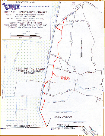 |
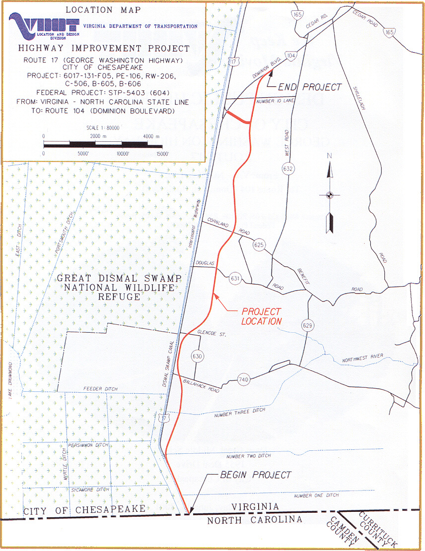
The following image
is of the location map from the Design Public Hearing brochure, available
at the project's Design Public Hearing on June 13, 2001. VA-104 has since been changed to US-17, with the original US-17 through Deep Creek being changed to Business US-17. Click image for larger image (114 kilobytes). Large image (526 kilobytes). |
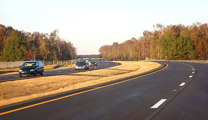
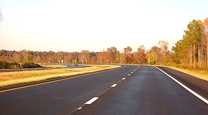
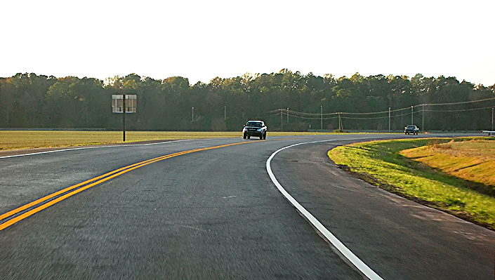
Roads to the Future took the following photos on November 12, 2005. A 2.2-x telephoto lens exaggerates the highway's curvature, as it is easily drivable at 60 mph. The new highway was driven in both directions a couple times, and it is very nice, with steady traffic and with ample room for the traffic volumes. The terrain is very flat and close to the water table, and the highway is typically elevated on embankment about 8 feet above the surrounding terrain, to assist in drainage and to prevent flooding of the highway. Nearly all of the old highway was open to motor vehicular traffic on the November 12th trip, and about 1/2 mile of new 2-lane parallel roadway remained to be constructed and opened at the seamless connection with pre-existing US-17 at the northern end of the project, and 2-lane 2-way traffic was using the new northbound roadway at that point; and the southern 1.3 miles of the project had construction underway on the southbound roadway with one lane open to traffic. All of the rest of the 2-lane northbound roadway and all of the rest of the 2-lane southbound roadway, and the Business US-17 connector, was fully open to traffic.
Click the thumbnail photo for a large photo (they average about 170 kilobytes).
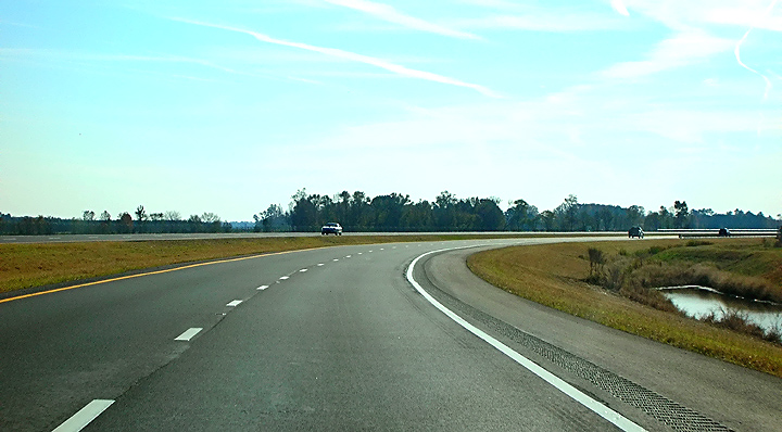
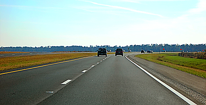
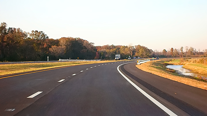
| The following 7 photos comprise in order a drive southbound from the north end of the project to the south end of the project. | |
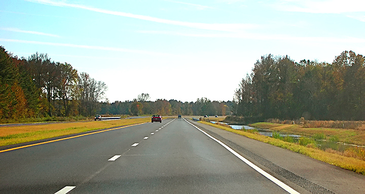 |
US-17 relocation, south of the Business US-17 junction, driving southbound. Notice the deep and wide drainage channel to the right. |
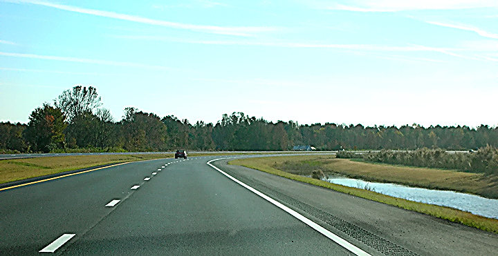 |
US-17 relocation, south of the Business US-17 junction, driving southbound. Notice the deep and wide drainage channel to the right. |
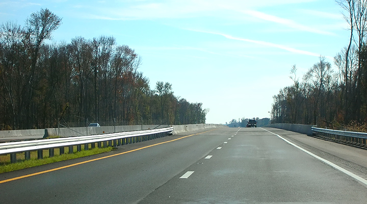 |
US-17 relocation, south of the Douglas Road intersection, driving southbound. Notice the bridge over the wetlands, ahead, which is a few hundred feet south of Douglas Road. The highway has twin bridges over wetlands, each 984 feet long. |
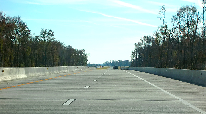 |
US-17 relocation, driving southbound, on the bridge over the wetlands. |
 |
US-17 relocation, driving southbound, on the bridge over the wetlands. |
 |
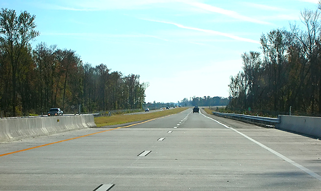
US-17 relocation, driving southbound. Notice the long curve, which is about 1,500 feet south of the wetlands bridges, or about 4,500 feet south of the Douglas Road intersection. |
 |
US-17 relocation, driving southbound, near Ballahack Road intersection. |
.
| The following 5 photos comprise in order a drive northbound from the south end of the project to the north end of the project. | |
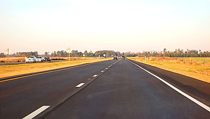 |
US-17 relocation, about 1/4 mile south of the Ballahack Road intersection, driving northbound. Notice the wide open farmland area. |
 |
US-17 relocation, just north of the Ballahack Road intersection, driving northbound. Notice the deep and wide drainage channel to the right. |
 |
US-17 relocation, about 1/4 mile north of the Glencoe Street intersection, driving northbound. Notice the high chain link wildlife fence. The wetlands bridges are visible in the far distance. |
 |
US-17 relocation, approaching the Cornland Road intersection, driving northbound. The Fall leaf-turning is well underway. |
 |
The new 2-lane Business US-17 connector has a seamless high-speed connection with the pre-existing Business US-17. |
The VDOT Dashboard
entry on January 15, 2007, for project
Route 17,
state project 6017-131-F05,C-506,B-605,B-606,D-607
had the following data points:
Contract Start Date -
Contract Original Specified Completion Date - November 1, 2005
Contract Acceptance Date - January 13, 2006
Contract Award Amount - $41,039,685
Un-audited Final Cost - $40,185,809
Governor Warner Kicks Off U.S. Route 17 Project in Chesapeake, VDOT news release,
March 28, 2003. Excerpts follow (in blue text):
Route 17 is currently a two-lane undivided
highway from Dominion Boulevard to the state line. It widens to four lanes in
North Carolina. The Virginia Department of Transportation (VDOT) will add two
lanes on the east side of Route 17 for about 1.3 miles north of the state line.
The $41 million project will also include the construction of a new 10.3-mile
section about 1,000 yards east of the current road. The project is slated for
completion in the fall of 2005.
In 2001, Route 17 carried about 10,000 vehicles daily with volumes projected to increase to 19,400 by 2020. The new Route 17 will allow for a more free flow of traffic by restricting areas where traffic enters and exits the road.
Route 17 Widening, VDOT project website.
Route 17
-- The Four Decade Project,
Public Roads
magazine, Federal Highway Administration,
May/June 2005. Excerpts follow (in blue text):
The U.S. 17 widening project in southeastern Virginia adjoining the world-renowned Great Dismal Swamp National Wildlife Refuge includes a donation of 307 hectares (758 acres) of wetlands, construction of a bear crossing, and installation of culverts that will serve as crossings for smaller wildlife. From the beginning, the project seemed like a "Catch-22" situation. U.S. 17, which runs along the eastern line of the Dismal Swamp Canal, needed to be widened because it could no longer handle the heavy traffic between North Carolina and Virginia. Various alignments were considered, but they all seemed to come down to this: people or wetlands? One alternative would affect only 4.5 hectares (11 acres) of wetlands but would mean displacing 33 families and taking parts of 80 other properties. Another alignment involved fewer families, but 22 hectares (55 acres) of wetlands would be affected.
The U.S. 17 widening project in southeastern Virginia will include construction of wildlife crossings that will enable bears and other animals to move safely within the Great Dismal Swamp area.
Before a solution could be found,
the Commonwealth faced a State budget shortfall, and money for the project was
pulled. Although North Carolina went ahead and built its portion of the road 20
years ago, Virginia's Route 17 widening project languished for years. When it
resurfaced, the Virginia Department of Transportation (VDOT) had to reinitiate
the National Environmental Policy Act process and prepare an Environmental Impact
Statement; pursue all of the permits again; interpret and decipher new, tougher
regulations; and face increased resistance from environmentalists.
To complicate matters, the
U.S. Army Corps of Engineers owned the land beneath Route 17, but not the roadway.
And VDOT was unable to produce documentation showing that it owned the right-of-way
along the existing road. In the meantime, the U.S. Environmental Protection Agency
(EPA) also had designated the aquatic resources in the area as "aquatic resources
of national importance" (ARNIs) which, by agreement with the U.S. Army Corps of
Engineers (USACE), is normally the first step that is taken in vetoing any permit
that the USACE might issue. EPA pledged to veto the project because of impacts
to organic soil wetlands and the national importance of the Great Dismal Swamp.
Federal regulators said that States just do not build roads through this type
of wetland anymore.
A solution was finally found: a shift in the alignment of the road 305 meters
(1,000 feet) to the east and construction of parallel 300-meter (984-foot)-long
bridges that ultimately displaced only one family and affected only 10 hectares
(25 acres) of wetlands.
Copyright © 2006-2007 by Scott Kozel. All rights reserved. Reproduction, reuse, or distribution without permission is prohibited.
All photos by Scott Kozel.