
| US-33 Stanardsville Bypass and Projects in Greene County |
US-33 Stanardsville Bypass and Projects in Greene County
The US-33 Stanardsville Bypass in Greene County, Virginia opened to traffic on June 13, 2000. This is a 2.1-mile-long 4-lane divided limited access highway with several at-grade intersections. There are no grade separations.
The length of the US-33 bypass is 2.1 miles, and the length of the entire set of bypass-related US-33 projects is 4.5 miles. Most of the portion just east of the bypass was built on new location, but immediately parallel to existing US-33 about 100-150 yards away, and in those places the old US-33 was given a secondary route number. The road through town is now Business US-33. The VDOT FY2000-2001 Virginia Transportation Development Plan (Six-Year Program) lists $11.9 million as the final costs of these projects.
Included in the Stanardsville area projects was the dualization, reconstruction and relocation of about one-and-1/2 mile of 2-lane US-33 east of the town, and about 3/4 mile of dualization and reconstruction of 2-lane US-33 west of the town. The dualizations were completed in January 2001. The result is 4.5 miles of 4-lane divided highway, including the 2.1-mile new location 4-lane bypass highway south of the town.
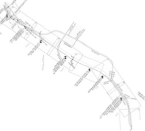 |
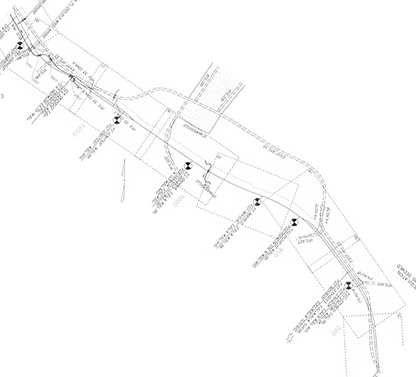
The 4.5-mile-long US-33 projects referenced above, including the 2.1-mile-long Stanardsville Bypass. This map is from the VDOT design plan document. The solid line is the centerline of the newly constructed highway, and the dashed line from lower right to top left is the original US-33. The small boxed area near the center of the photo with dots is the town of Stanardsville. The north arrow is in the left center of the image, and as you can see I rotated the image about 135 degrees so that north would be directly upward. Large image (53 KB). |
The town has about 2,000 population in and around the town, which is not very large, but still there is enough local and interregional traffic, that the bypass and the 4-laning is a welcome improvement. The Business US-33 through town is an urban 2-lane street with long stretches of speed limits of 35 mph and some 25 mph, and there is a traffic signal at VA-230 in the center of town. Stanardsville is a charming little town in the Blue Ridge foothills. The bypass provides a 60 mph design speed and a 55 mph speed limit. So the through traffic can pass by at high speed, and the town has a quieter main street for local traffic.
In 1997, 3.6 miles of US-33 dualization was completed between east of Stanardsville and US-29 at Ruckersville, at a cost of $5.3 million, and the Stanardsville projects completed in 2000 and 2001 extended the 4-lane highway westward from there. The result is 8.1 miles of 4-lane divided highway from Arterial US-29 westward, including the bypass around Stanardsville, and the total cost of all the above projects was $17.2 million. The former highway was two lanes wide throughout.
The final designs were completed and the right-of-way was purchased for these 8.1 miles of projects back in the early 1970s, but due to later funding limitations and higher construction priorities, no construction began until 1995. The same basic designs were used, although updated to use modern standards.
It is a nice highway, and a real improvement for both through traffic and local traffic. The view is very nice, with rolling terrain and the Blue Ridge Mountains visible west of the town.
There are 3.8 miles of 2-lane highway on US-33 west of the western limit of the currently completed projects, that are a candidate for Arterial 4-laning, but it is not in the VDOT Six-Year Program, not even for preliminary engineering. I would like to see this portion 4-laned.
The 38 miles of US-33 from I-81 at Harrisonburg to US-29 at Ruckersville is part of the 1,850-mile-long Virginia Arterial System that was designated in 1964 for 4-laning and bypasses around major towns. An exception (no Arterial construction planned) is the 4-mile-long US-33 portion through Shenandoah National Park, which is a mountainous winding 2-lane highway with continuous climbing lanes, passing through the Swift Run Gap area and accessing Skyline Drive, reaching a maximum elevation of almost 2,400 feet.
The portion of US-33 in Rockingham County from I-81 to the edge of Shenandoah National Park was all 4-laned, including a new location bypass of Elkton, by 1972.
The 4 miles of US-33 through Shenandoah National Park passes through mountainous Blue Ridge Mountains terrain, and it would involve massive new location construction with large cuts and fills if it is ever built as a high-speed 4-lane divided highway, and such construction would involve permission from the National Park Service, which is unlikely. The existing highway is reasonably good, basically three lanes that look 12 feet wide each, with some shoulders; and even though there are some 25 mph and 30 mph curves, still a motorist can average 40 mph or more overall, and there are several truck escape ramps.
Average daily traffic volumes on US-33 in 2002 were 13,000 to 17,000 between Stanardsville and US-29 at Ruckersville, 3,000 on the Stanardsville Bypass, 4,800 just west of the Stanardsville Bypass, and 4,700 at the junction of Skyline Drive in Swift Run Gap; and these sections carry 8% large trucks. The average daily traffic volume on Business US-33 through Standardsville ranges from 2,700 west of VA-230 to 4,800 east of VA-230. Traffic volumes from Average Daily Traffic Volumes with Vehicle Classification Data on Interstate, Arterial and Primary Routes, by Virginia Department of Transportation, 2002.
Sources: VDOT FY2000-2001 Virginia Transportation Development Plan (new name for Six-Year Improvement Program), VDOT FY1999-2000 Six-Year Improvement Program, VDOT US-33 project design engineer.
US-33 Stanardsville Bypass and Projects - Photos - my webpage with four photos.
Copyright © 2001-2004 by Scott Kozel. All rights reserved. Reproduction, reuse, or distribution without permission is prohibited.
By Scott M. Kozel, Roads to the Future
(Created 3-1-2001, updated 2-1-2004)