
| Washington Bypass Studies |
Washington Bypass Studies
Maryland and Virginia jointly conducted a Washington Bypass Study from 1988 to 1990, which evaluated eastern and western outer freeway bypass routes.
I have the Washington Bypass Study newsletters and brochures from 1988 to 1990, which were published jointly by the Virginia Department of Transportation (VDOT) and the Maryland Department of Transportation, State Highway Administration (MDOT SHA). This study evaluated outer freeway bypass alternatives for the Washington, D.C. metropolitan area.
One of the local newspaper articles from during that study period, was from the Washington Post, "An Ambitious Gridlock Remedy", from May 5, 1990. The sub-heading says, "As Beltway Groans Under Traffic Burden, Bypass Plan Dusted Off". It is about the proposals for an eastern bypass and a western bypass of the D.C. area.
Excerpt from article (blue text):
The Beltway can't carry interstate travelers and trucks carrying goods between the Northeast and the South -- its original purpose -- as well as the swelling volume of local traffic brought on by the burst of growth in the suburbs. Month by month, Washington's 64-mile Main Street becomes slower, more dangerous and overloaded, prompting many fed-up drivers and policy-makers to revive the 40-year-old plan to build a new bypass.Maryland's proposal in 1990 was to build an eastern bypass, with alternatives ranging up to 93 miles in total length, with the various alternates costing from $1.4 to $1.7 billion (estimated total cost for engineering, right-of-way and construction in 1990 dollars). Virginia officials agreed with Maryland's plan, but wanted their own western bypass; it would have been in a similar price range, and up to 82 miles long.
Excerpt from article (blue text):
The roads, together dubbed the Washington Bypass, wouldn't hook together in a circle like the Capital Beltway, but would tie into existing highways. Whether to build all or part of the bypass is shaping up as this region's most important and complex transportation and development issue since the decision to build Metrorail.The Washington Bypass Study was a joint project between Maryland and Virginia. In 1990, the two governors, L. Douglas Wilder of Virginia and William Donald Schaefer of Maryland, were committed to deciding whether their states should build part or all of these bypasses, before the turn of the century.
 |
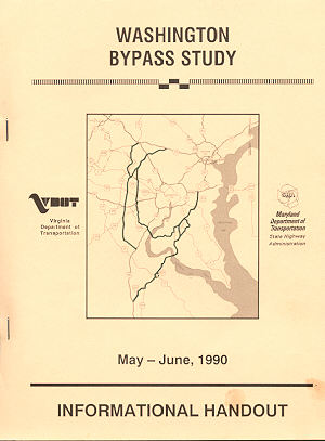
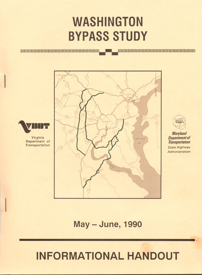
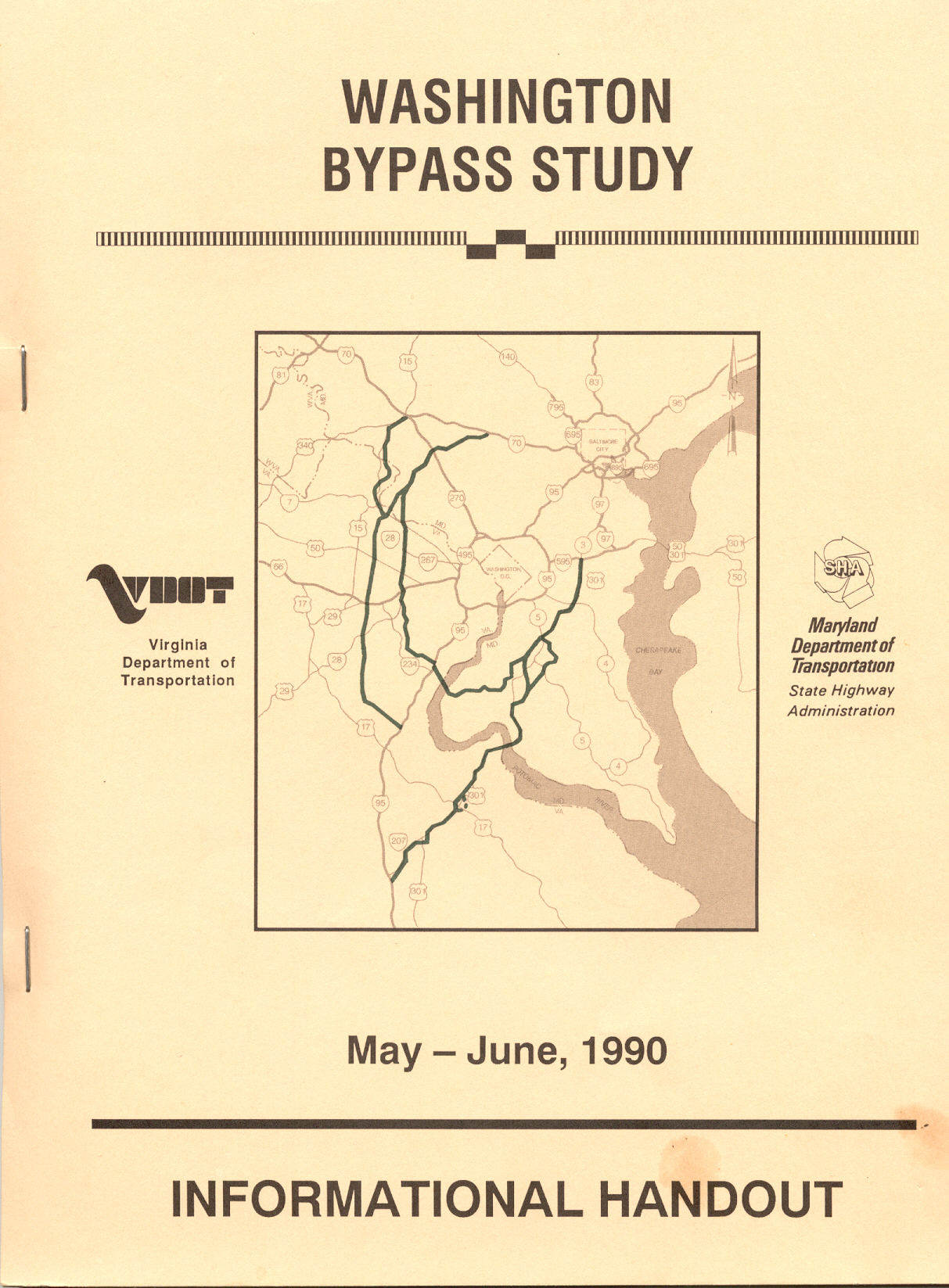
Cover of Washington Bypass
Study Informational Handout public hearing brochure, May-June 1990,
published jointly by Virginia Department of Transportation (VDOT) and Maryland
Department of Transportation State Highway Administration (MDOT SHA).
Click for larger map images: Medium (24K), Large (84K), Extra Large (266K). |
Study consultants said that a new highway circling up to 175 miles in total length, to the west and east of Washington could change the definition of the region as much as the Capital Beltway did, possible bringing with it more than 200,000 new population and 174,000 new jobs. They also acknowledged that much of that growth would occur anyway, but that an outer bypass would serve as a catalyst and focal point for economic activity.
Critics asserted that the Western Bypass would not provide much traffic relief to the Beltway, that it was promoted by Northern Virginia developers, and that Dulles Airport interests want to increase airport access. Critics along the corridor of the Eastern Bypass questioned whether or not it is a true bypass. Some people in Virginia contend that Maryland wants the Eastern Bypass in order to aid the Port of Baltimore and Baltimore-Washington International (BWI) Airport at the expense of Virginia's ports and airports. Conversely, some people in Maryland contend that Virginia wants the Western Bypass in order to aid Washington Dulles International Airport at the expense of Maryland’s BWI Airport.
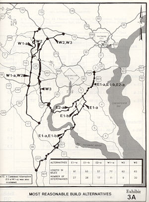
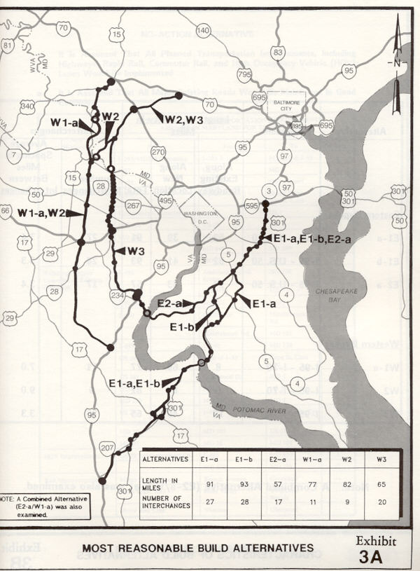
In the Washington Bypass Study, there were two basic proposals for the Eastern Bypass. Both would have followed the US-301 corridor from US-50 near Bowie to the Waldorf-LaPlata area. From there, one alternative would have continued down the US-301 corridor, into Virginia, junctioning with I-95 at Carmel Church. The other alternative would have followed a new location from Walforf, Maryland, to Dumfries, Virginia, including a new Potomac River bridge near Chicamuxen, Maryland. The 61-mile-long second alternative would have been the cheaper of the two. Lane widths would be six lanes throughout for the Chicamuxen alternative, and six lanes north of Waldorf for the Carmel Church alternative, with four lanes south of there. All alternatives would be built to full freeway standards. The estimated total cost (engineering, right-of-way and construction) in 1990 dollars for the Chicamuxen alternative was $1.4 billion, and for the Carmel Church alternative was $1.7 billion.
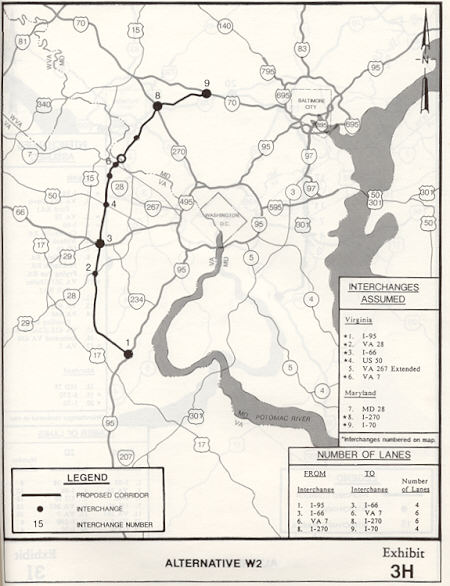
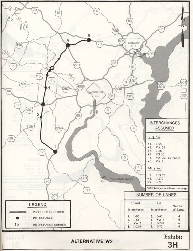
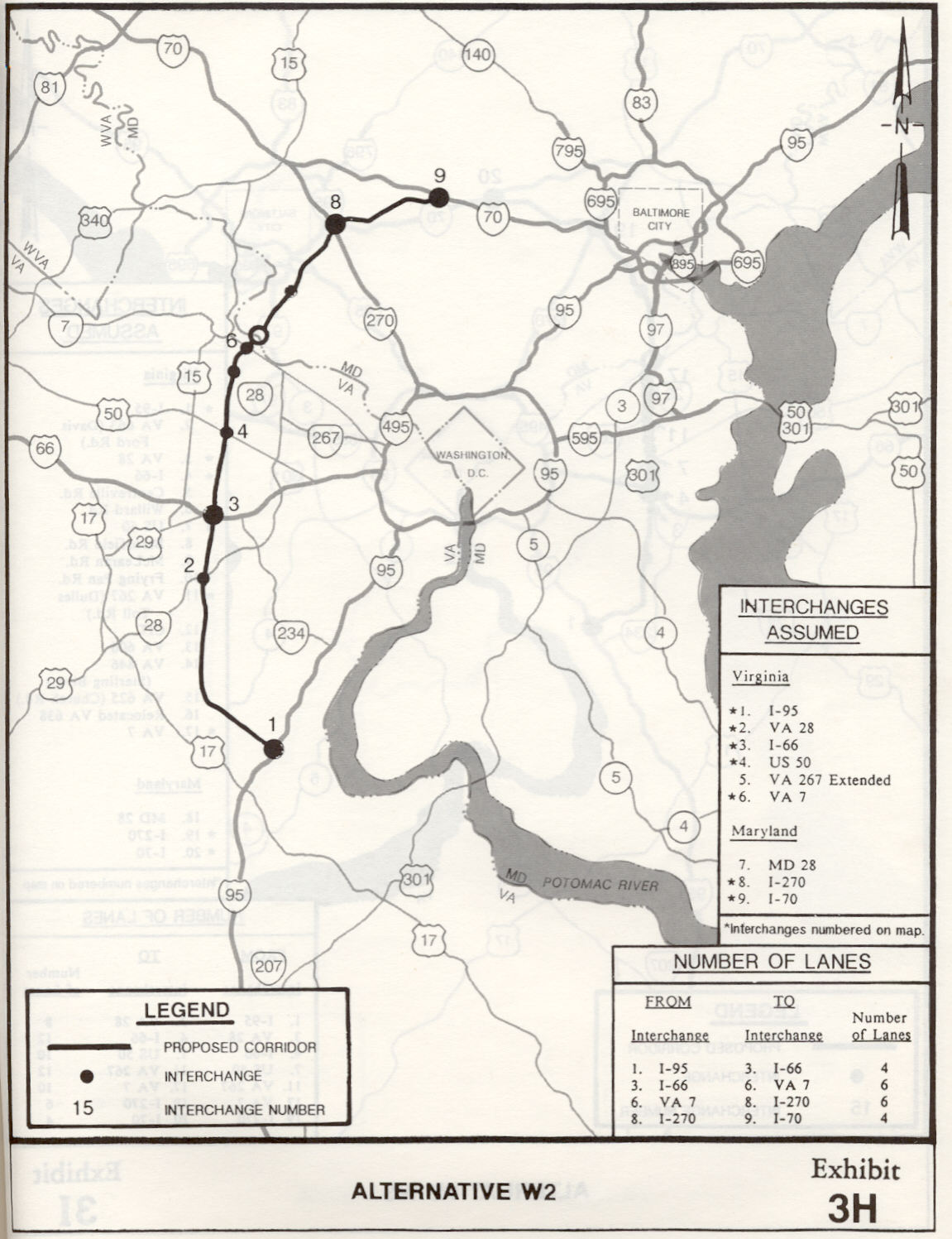
In the Washington Bypass Study, there were two basic proposals for the Western Bypass. The one closer to D.C. would have started at I-95 near Dumfries, Virginia, and would probably have a direct link with the Chicamuxen alternative of the Eastern Bypass. It would follow the VA-234 corridor to Manassas, pass east of the town, and then follow an upgraded VA-28, passing by Dulles Airport, crossing the Potomac River into Montgomery County, junctioning I-270 near Clarksburg, ending at I-70 near Mount Airy. Lane widths would be eight lanes from I-95 to I-66, ten to twelve lanes from I-66 to VA-7, six lanes from VA-7 to I-270, and four lanes from I-270 to I-70. The road would be built to full freeway standards, and cost about $1.4 billion (estimated total cost for engineering, right-of-way and construction in 1990 dollars).
The other Western Bypass alternative was much further west. It would start at I-95 near Stafford, Virginia, and pass west of the Quantico Marine Base (USMC), cross I-66 just east of Gainesville, pass west of Dulles Airport, pass east of Leesburg, cross the Potomac River, and join the previously described alignment in Montgomery County (junctioning I-270 near Clarksburg, ending at I-70 near Mount Airy). A sub-option of this second Western Bypass alternative, would be to follow the US-15 corridor from Leesburg to Frederick, Maryland, with a Potomac River bridge at Point of Rocks, Maryland. Lane widths would be four lanes from I-95 to I-66, six lanes from I-66 to VA-7, six lanes from VA-7 to I-270, and four lanes from I-270 to I-70. The road would be built to full freeway standards, and cost about $1.4 billion (estimated total cost for engineering, right-of-way and construction in 1990 dollars).
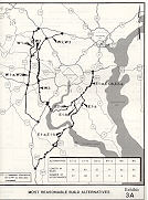 |
Map of Most Reasonable
Build Alternates, from Washington Bypass Study Informational
Handout public hearing brochure. Keep in mind that only one western alternate
would have been chosen, and/or only one eastern alternate would have been
chosen.
Click for larger map images: Medium (34K), Large (93K), Extra Large (247K). |
My personal observations follow. From the data and analysis I've seen, the Eastern Bypass would seem to provide more traffic relief than the Western Bypass. However, the planning stopped around 1994 for the Waldorf to Dumfries section, due to local concerns about development growth and environmental impacts in Maryland. US-301 improvements are still planned from Waldorf to US-50. My belief about the Eastern Bypass alternative down US-301 to Carmel Church, Virginia, is that it is too long, too expensive, and too far away to be an effective bypass.
Regarding the assertion by some people in Virginia who contend that the Eastern Bypass would economically hurt Virginia's ports and airports, and regarding the assertion by some people in Maryland that the Western Bypass would economically hurt BWI Airport: My opinion is that either worry scenario is way overblown, and that insufficiency in the regional highway system, caused by lack of a regional bypass, will hurt the ports and the airports in both states.
One of the good things about the Chicamuxen crossing of the Potomac River, is that it would tie to the inner Western Bypass alternative; and that would provide an east-west outer bypass for the I-66/US-50 corridor. It would also provide another Potomac River crossing for the Washington area.
Virginia seemed to be leaning toward the outer Western Bypass alternative. In my opinion, it seems to be more of a true outer bypass than the Virginia inner alternative. The inner corridor has improvements already planned or completed, arterial-type improvements rather than freeways. VA-234 is planned for four-lane widening and a bypass west of Manassas, and as of 2003, the VA-234 Manassas Bypass is complete (completed in 2002 at cost of $147.2 million for 7.8 miles of new location 4- and 6-lane limited access highway) and part of the VA-234 widening has been completed between Manassas and I-95, with all the widening planned for completion by 2005. VA-28, formerly a two-lane highway, was upgraded to six-lanes with partial control of access, with completion in 1991. The inner alternative also would result in a massive dual-divided highway along the VA-28 section from I-66 to VA-7, because of the very high traffic volumes. A project is now underway to add interchanges to VA-28, and the eventual plan is to make VA-28 eight lanes wide and freeway standard throughout, between I-66 and VA-7 Leesburg Pike. See Route 28 Public/Private Partnership website.
Another concern with the Western Bypass, is the fact that it might not go north of Leesburg, because far northwestern Montgomery County, Maryland, is designated as an agricultural reserve, and local county officials are concerned about the development that might follow the road and impact the reserve. In my opinion, what is needed there, and indeed on the whole Western Bypass, is widely-spaced interchanges (e.g. 6 to 8 miles or more apart) so that the road can function as a true outer bypass, with limited local traffic on the highway. The solution for Montgomery County might be to have interchanges only at I-270 and I-70. That would sharply limit any development. And I favor building the outer alternative in Virginia, for the same reason.
Something needs to be done; the interstate through-traffic on I-95, I-66 and I-270 needs to be able to bypass the D.C. area. The planners of the Capital Beltway, back in the 1950s, recognized that the Beltway would one day need to be bypassed by an Outer Beltway.
Radical environmentalist/transit groups have a conniption fit whenever the subject arises of building one or more of the outer Washington bypasses. Their obstructionist tactics are, in my opinion, selfish and misguided. A regional bypass is needed to handle current and future traffic volumes, and if the RE/T groups are worried about “sprawl” following the building of these highways, then the wide interchange spacing scenario that I mentioned above could be utilized to sharply limit future development near the interchanges.
As far as financing, there are a variety of potential sources of funding to build these highways. One or a combination of the following could be utilized: conventional state and federal road user tax revenues, state-issued toll revenue bonds, and private capital through public-private partnerships (Virginia has public-private partnership enabling legislation, but Maryland does not yet). Utilizing the last two sources would mean that the highway would have a toll, but I think that if tolls are needed to finance these highways, then I am all for it.
Only one of these projects was studied recently, the Western Transportation Corridor in Virginia. See Western Transportation Corridor on the VDOT website. This VDOT study was cancelled in April 2003.
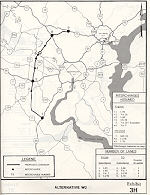 |
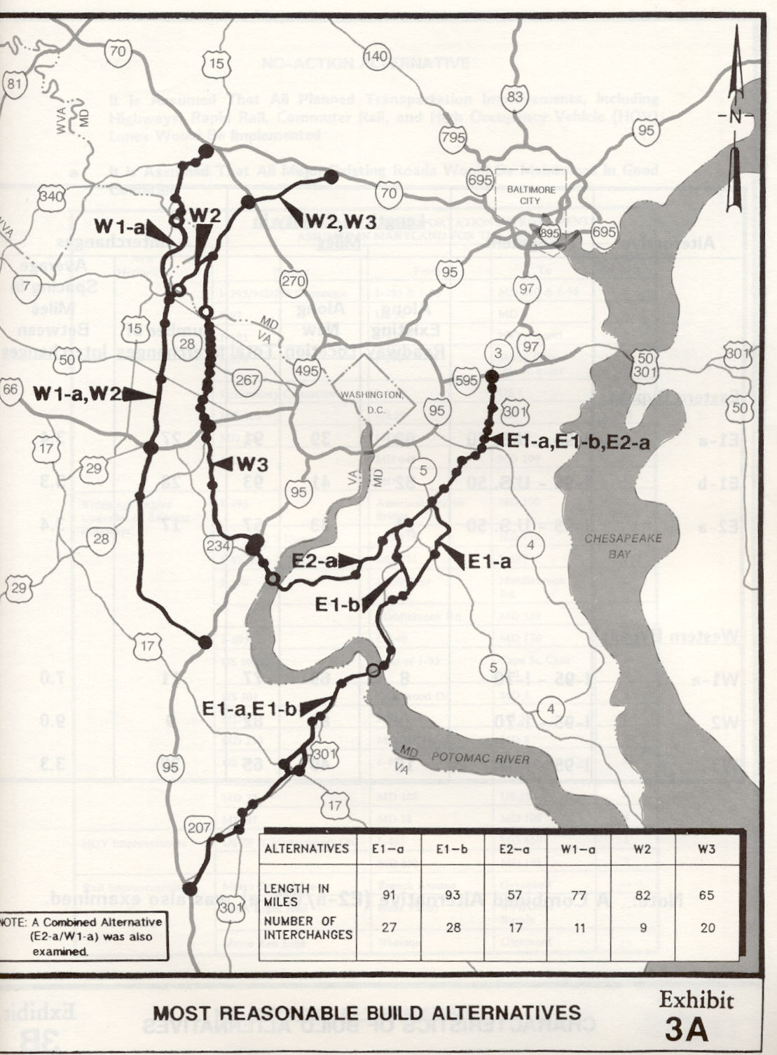
Alternative W2, from
Washington Bypass Study Informational Handout public hearing brochure.
This would be the the Western Transportation Corridor extended to its logical
northern terminus with I-70 at Mount Airy, Maryland.
Click for larger map images: Medium (53K), Large (102K), Extra Large (234K). |
Copyright © 2000-2004 by Scott Kozel. All rights reserved. Reproduction, reuse, or distribution without permission is prohibited.
By Scott M. Kozel, Roads to the Future
(Created 11-12-2000, updated 6-5-2004)