
| Arterial Highway System in Virginia |
Arterial Highway System in Virginia
The Arterial Highway System in Virginia is a 1,855-mile-long system of intra-state highways, first established in 1964, designed to supplement and augment the 1,128-mile-long Interstate Highway System in Virginia. The Arterial highway concept is to provide continuous a 4-lane-divided highway with new location bypasses around major towns. This was done mostly by building a 2-lane parallel roadway next to an existing major primary highway roadway, providing a 4-lane divided highway; and also by building the 4-lane town bypasses to bypass the existing through-town primary thoroughfares. Some selected rural locations necessitated a complete relocation when dualization would not provide an adequate alignment, but the vast majority of the rural mileage was dualized. When the Arterial system was begun in 1964, the target for completion of financing of the system was 1975, and the national Interstate highway system was projected for completion of financing in 1972. The 1972-1982 Virginia 10-year highway program revised the year to 1982 to have all the mileage of the Arterial system completed or under construction.
Most state DOTs were experiencing funding limitations during the era about 1972-1984; slowdowns in road construction occurred in most states in that era as inflation and increases in the cost of completing the Interstate highway system occurred, stretching out the completion of the Interstate system, with relatively stagnant levels of funding for state and federal highway programs during periods of national inflation, with various national recessions; all these factors led to the stretching out of the completion of the Arterial system. The final completion of the Interstate system in Virginia didn't occur until 1992, and the Arterial system is still not complete in 2000 although over 90% of its mileage is complete.
The highways chosen to be Arterial highways were major intra-state highways that were already carrying considerable volumes of cars and large trucks. The Arterial highways interconnect with the Interstate highway system, and the Arterials provide modern 4-lane highway service to many towns and cities in the state that are not directly served by the Interstate system, connecting them to each other, and to the towns and cities on the Interstate system. Some of the Virginia Arterial highways continue as de-facto arterial 4-lane highways in adjoining states, providing similar service to towns and cities in those states.
The National Highway System (NHS) was permanently designated in ISTEA of 1991 (the federal Intermodal Surface Transportation Efficiency Act of 1991, a six-year federal transportation bill). Nearly all of Virginia's Arterial System was incorporated into the NHS, since the 150,000-mile-long NHS is essentially comprised of the 44,500-mile-long Interstate Highway System plus designated major rural arterial highways. The NHS is a similar concept to what Virginia established in 1964.
The Virginia Arterial Highways do not have a special sign designation on the highways, they have the same state and U.S. route signing as do other routes. I'm not sure if I have seen the Virginia Arterial Highway System mentioned in the news media since ISTEA; perhaps the NHS has replaced it in current popular thought. Still, the history is important and most of the Arterial system (over 80%) was built before the NHS was established in 1991. So I am providing this history.
A New Study, A New Network
Following (in blue text) is a direct excerpt from A History of Roads in Virginia, "the most convenient wayes", a 35-page booklet published by the Virginia Department of Transportation (VDOT), Office of Public Affairs, in cooperation with the Virginia Transportation Research Council (VTRC), 1989.
It soon became evident, however, that the interstate routes alone would not adequately serve the burgeoning population and the increasing desire for mobility by Virginians in the second half of the 2Oth century. The spreading suburban growth that marked Virginia and other states in the years after World War II was induced in large part by the flexible mobility permitted by the family auto. Suburban housing development was followed by suburban shopping centers and office buildings. It all placed new demands on the state's roads and streets. The 20-year improvement plan that had been implemented by the commission in the immediate post-war years had to be revised and updated frequently to keep pace with changing needs and growth patterns.
In 1962, the General Assembly established a new study commission to examine and evaluate highway needs, revenue, fund distribution procedures and the organization of the Department of Highways. It consisted of one member from each of the eight construction districts and two citizens at large. The study commission members were appointed by Gov. Albertis S. Harrison Jr., in May 1962, with Sen. William F. Stone of Martinsville, an experienced legislator who had been a chief patron of the act calling for the study, chosen as chairman.
For more than a year, the study commission went about its assignment, reviewing nearly every aspect of the highway program. The commission itself probably was the most important highway study group since the 1916 committee that recommended the establishment of the first state highway system.
The Stone commission submitted its report to the governor and the General Assembly in December 1963, in time for its recommendations to be considered at the legislative session beginning the following month.
Among its points: "One of the prime factors in inducing business management to select a state for expansion or a new location is a good highway system which not only is needed for transportation of goods and raw materials but enables employees to be drawn from a wide radius. Some other states have moved ahead of Virginia in expanding their highway systems; we cannot afford to be left behind."
The study commission also described the motor vehicle as "an essential and integral part of our everyday life. Its impact upon our economy and way of life has reached dimensions which have exceeded all forecasts."
In an effort to keep up, the commission said, a new arterial network should be developed to supplement the interstate system.
Douglas B. Fugate, who had joined the department shortly after his graduation from Virginia Military Institute with a degree in civil engineering in 1927, was serving as assistant chief engineer at the time and in 1964, was appointed commissioner by Gov. Harrison. Fugate proposed the arterial network concept to the study commission and thus become chief architect of the network.
"The arterial road program, when completed, will in conjunction with the interstate system connect every city within the Commonwealth of 5,000 or more and nearly every town having a population of 3,500 to 5,000. When completed, there will be an arterial route or interstate route within a 40-mile radius of every town in Virginia,"
the study commission said.Development of the network was authorized by the 1964 General Assembly, which also provided additional revenue through increases in the state's motor vehicle registration and operator's license fees. As approved, it totaled more than 1,700 miles and was to be developed chiefly by building new two-lane roadways parallel to existing two-lane primary routes to create four-lane, divided facilities. More than 70 bypasses of cities and towns were to be constructed, to free local streets for local traffic, and many of the bypasses would be constructed virtually to interstate standards.
The arterial network was half-finished within seven years after it began. In some quarters, the network was described as a "model for the nation because of the orderly way in which it insured upgrading of older primary roads while the interstate system development was still under way."
In the mid-1950s, when the interstate program was beginning, Virginia had about 300 miles of multi-lane divided highways. With interstate and arterial completion, it would have slightly more than 3,000 miles of such roads.
[end of direct excerpt quote]
Virginia's Roads and Streets 1972-1982 - A 10-Year Program
The Virginia Advisory Legislative Council (VALC) produced the public report Virginia's Roads and Streets 1972-1982 in December 1971, and this is the 1972-1982 Virginia 10-year highway program that I referred to earlier. Its objectives included having the Interstate highways completed or under construction, having the Arterial highways completed or under construction, plus extensive improvements to the regular primary highway system, plus extensive improvements to the secondary highway system, plus extensive improvements to the urban road system. It explained how the nine-year highway improvement plan from 1965 to 1974 was behind schedule, due cost inflation in the heavy construction industry, due to many increases in highway design standards and safety standards with resultant higher costs, due to increasing environmental protection standards, also due to the stretchout of the completion of the Interstate system date (in 1965 it was targeted for 1972) with the concurrent need to fund that fully and the inability to divert funds from the Interstate system once it was completed, to other major primary and urban highways and streets. The nine-year highway improvement plan from 1965 to 1974, even if completed on schedule, would have left many desirable improvements unmet, because it proposed doing only what was considered essential to provide a "minimum, tolerable" road system by 1975. The increased standards were a major reason for stretching out the time needed to complete the Arterial network. The system was one-half complete by 1971, but many of the remaining unbuilt segments were among the most difficult and expensive to construct. The town bypasses were expensive to build since they were built on entirely new locations, and the various increased standards made the remaining bypasses even more expensive. The report stated,
"Original plans called for the bypasses to be constructed with little or no grade separation, for economy reasons. Time and again, however, citizens have urged such features, and as a result most bypasses are being built virtually to Interstate system standards, with these added safety measures". At the point of this December 1971 report, 950 miles or 55% of the Arterial system was complete, with 90 miles under construction; and 815 miles (or 76%) of the then-1,077-mile-long Virginia Interstate system was complete, with 47 miles (or 4%) under construction and 215 miles in planning stages.The 1972-1982 Virginia 10-year highway program also provided increased state funding for mass transit. The VALC report made comments about the following issues. The General Assembly in 1970 authorized the use of highway funds for such transit-related projects as construction of exclusive bus lanes, off-street parking lots in fringe areas and downtown areas, bus turnouts, and passenger shelters. The Virginia Department of Highways also joined with the Northern Virginia Transportation Commission (NVTC) and the U.S. Department of Transportation's Urban Mass Transit Administration (UMTA) and Federal Highway Administration (FHWA) and the Metropolitan Washington Council of Governments (MWCOG) in conducting an experimental busway project on 10 miles of Shirley Highway (I-95) in Northern Virginia, with expressway lanes reserved for buses, to bypass congestion in the conventional lanes. Since the Shirley busway project was implemented in September 1969, as of the December 1971 date of this report, commuter bus ridership in that corridor had more than doubled in that period. This was the nation's first instance of Interstate highway lanes being reserved exclusively for buses, and it attracted the interest of many transportation agencies. See my
Henry G. Shirley Memorial Highway (I-95 and I-395) and Shirley Highway Busway/HOV System articles for details about the HOV/busway system. The December 1971 (VALC) report goes on to say that the Virginia Department of Highways was partnering with the City of Richmond, Henrico County, and the Richmond Regional Planning District Commission to arrange express bus operation between the western suburban area and the downtown, and highway funds were authorized for the purchase of land for fringe parking lots. These park-and-ride lots were built soon (a few years) afterward by the Virginia Department of Highways, and the Greater Richmond Transit Company (GRTC) added express commuter bus lines between the park-and-ride lots and the downtown, and the buses used Interstates I-64 and I-95 for most of the trip. The VALC report also mentioned the ongoing joint planning between the Virginia Department of Highways and the Washington Metropolitan Area Transit Authority (WMATA) for building six miles of new Interstate I-66 as a multi-modal corridor with the Metrorail Vienna Route rapid rail transit line and four stations in the median of the highway, and this included planning for the westernmost three miles of the Metrorail line being placed in the median of a portion of I-66 that had already been built west of I-495. The I-66 highway between I-495 and the Theodore Roosevelt Bridge over the Potomac River was opened in 1982, and the Metrorail line in the median opened in 1986. See my article Interstate 66 and Metrorail Vienna Route for details.Current Arterial System Status and Arterial Bypasses
Going on to later years, the Arterial System was increased to 1,855 miles in 1990, with the additions of US-58 between I-77 at Hillsville and Martinsville, VA-234 between I-95 and I-66, and US-17 between Warrenton and I-66. That is the current system size in 2000, and over 90% is 4 lanes today, with the remainder planned for 4-laning.
Here is a list of the current 86 Arterial bypasses, by route, and by town. When town is in brackets, that means that it is on an overlapping Arterial route and was previously accounted for in the list. A two-town hyphenation means that two towns are bypassed by one physical bypass. This also lists all the Arterial routes, since no Arterial route is without a bypass. See the system map links to see the exact routes of these highways.
VA-7 - Berryville, Round Hill, Purcellville, Hamilton, Leesburg
US-13 - Cheriton, Eastville, Exmore, Onley, Accomac
US-17 - Belleville, Gloucester, Saluda, Fredericksburg, Warrenton
US-19 - Lebanon, Tazewell
US-23 - Gate City, Big Stone Gap-Appalachia, Norton, Wise, Pound
US-29 - Danville, Chatham, Gretna, Hurt-Altavista, Lynchburg, Madison Heights,
Amherst, Lovingston, Charlottesville, Madison, Brightwood, Culpeper, Brandy Station,
Remington, Warrenton
US-33 - Elkton, Stanardsville
VA-37 - Winchester
US-58 - Hillsville, Stuart, Martinsville, Danville, Clarksville, Boydton, South
Hill, Lawrenceville, Emporia, Courtland, Franklin-Carrsville, Holland, Suffolk
US-58-ALT - Jonesville, Pennington Gap, Big Stone Gap, [Appalachia], Coeburn,
St. Paul
VA-207/US-301 - Bowling Green
US-211- Luray, Washington
US-220 - Ridgeway, Martinsville, Rocky Mount, Roanoke, Clifton Forge
VA-234 - Manassas
VA-288 - Richmond
US-360 - South Boston, Clover, Keysville, Burkeville, Amelia, Mechanicsville
US-460 - Richlands, Cedar Bluff, [Tazewell], Bluefield, Pearisburg, Blacksburg,
Christiansburg, Bedford, Lynchburg, Appomattox, Pamplin City, Farmville, [Burkeville],
Nottoway-Blackstone, [Suffolk]
The original 1,738-mile-long Arterial System had 76 bypasses. In addition to the 117 miles added in 1990, bypasses were added on original Arterials for Madison Heights, Jonesville, Danville (US-58), Clarksville, South Hill, Boydton, Warrenton (US-17), and the added mileage has bypasses on Hillsville, Stuart, and Manassas. The only remaining bypasses not yet open to traffic are Madison Heights, Hillsville, Stuart, Danville (US-58), Clarksville, Jonesville, Pennington Gap, and Big Stone Gap (US-58-ALT); only the last two were in the original system.
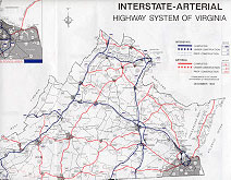
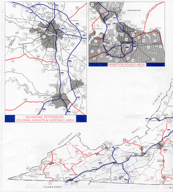
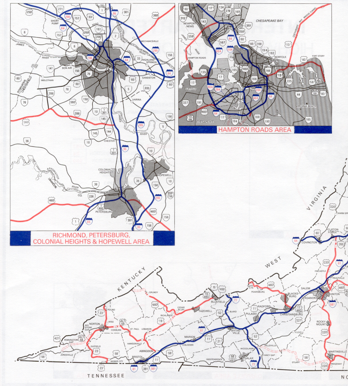
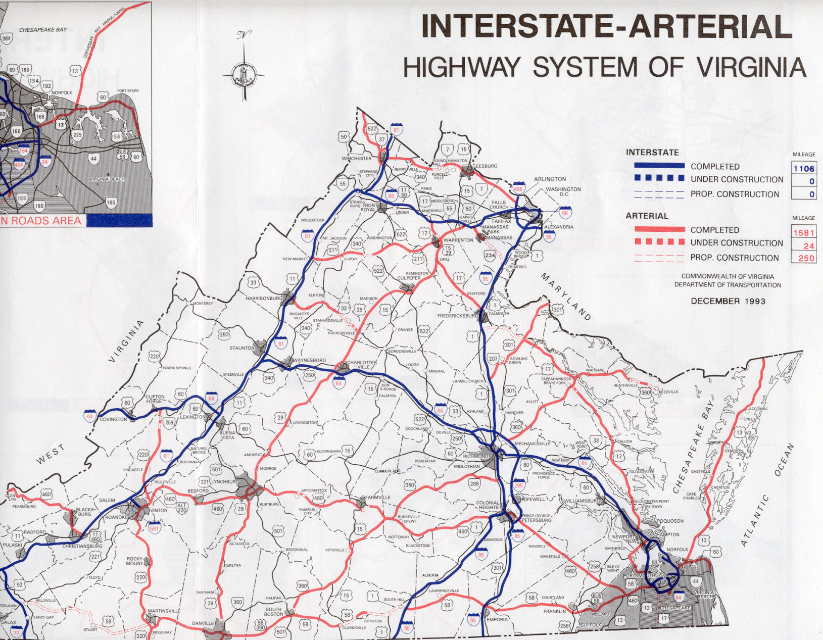
Here are map images of the map "Interstate-Arterial Highway System of Virginia".
 (1)……..
 (2)
(2)
(1) Click for larger map images: Medium (180K), Extra Large (665K).
(2) Click for larger map images: Medium (155K), Extra Large (470K).
Sources: A History of Roads in Virginia, "the most convenient wayes", a 35-page booklet published by the Virginia Department of Transportation (VDOT), Office of Public Affairs, in cooperation with the Virginia Transportation Research Council (VTRC), in 1989. Virginia's Roads and Streets 1972-1982, which is the 1972-1982 Virginia 10-year highway program report produced by the Virginia Advisory Legislative Council for the Virginia Highway Commission in December 1971. Maps "Interstate-Arterial Highway System of Virginia", various issues from 1972 to 1993.
Copyright © 2000-2004 by Scott Kozel. All rights reserved. Reproduction, reuse, or distribution without permission is prohibited.
By Scott M. Kozel, Roads to the Future
(Created 12-19-2000, minor update 7-3-2004)