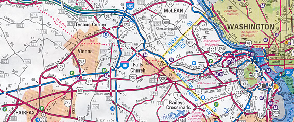
Current I-66 and US-29 Projects in Manassas-Gainesville Area

| Interstate 66 and Metrorail Vienna Route |
Interstate 66 and Metrorail Vienna Route
These two transportation facilities, Interstate 66 and the Metrorail Vienna Route, form an integrated multi-modal transportation corridor in Fairfax and Arlington Counties in Virginia, and this article discusses both, including the entire I-66 corridor.
Article index with internal links
Introduction
Interstate 66 Openings in Virginia and the District of
Columbia
Interstate 66 HOV (High Occupancy Vehicle) Operations
Coleman Approves 4-Lane I-66 Into Arlington
Interstate Cuts Through 24 Years of Hassles
Washington D.C. Suburban I-66 - Unique Compromise
in Expressway Design
Coleman Decision - Link to Official Document
Coleman Decision Repealed by Congress in
1999
Widening of I-66 Inside Beltway
Widening of I-66 Outside Beltway
Interstate 66 Traffic Volumes
Metrorail Vienna Route (K Route)
Arlington, Virginia - Smart Places
Metrorail Vienna Route Stations in I-66 Median
WMATA Baseline System Inventory - 1986 Update
Vienna Route Station Details
Directory of Articles With Photos
Legend
Introduction
Interstate 66 is the east-west limited-access freeway that runs 77 miles (124.2 km) from Interstate 81 near Strasburg, Virginia, to 22nd and K Street, N.W. in the District of Columbia. The D.C. terminus also includes high-capacity connections to Constitution Avenue, N.W. and E Street, N.W. The originally proposed but cancelled extension of 1-66 in D.C. is discussed in detail in the Roads to the Future article "Washington D.C. Interstates and Freeways".
Originally, I-66 inside the I-495 Capital Beltway was proposed to have six lanes (3 each way) from the Beltway to the Dulles Airport Access Road (DAAR) interchange, and eight lanes (4 each way) from the DAAR to near Spout Run Parkway in Arlington, where the six-lane Interstate 266 would have branched off; and I-66 would have been six lanes (3 each way) from there to the I-66 Theodore Roosevelt Bridge. I-266 would have crossed the Potomac on the Three Sisters Bridge (named after the Three Sisters Islands in the Potomac River), into Washington, D.C., then followed the river east to the Whitehurst Freeway, which would have been reconstructed as I-266, and I-266 would have ended at I-66 at K Street, N.W., in D.C. The proposed I-266 was essentially a trans-Potomac parallel corridor to I-66. The I-266 proposal was cancelled in the mid-1970s. I-66 was planned to extend under K Street in a tunnel, and emerge and terminate in a junction with I-95 about a mile north of the U.S. Capitol Building in D.C. That I-66 extension was cancelled also, in the mid-1970s. See also Mike Hale's articles Interstate 66 and Interstate 266 Unbuilt.
The original eight-lane I-66 proposal inside the Beltway was blocked due to citizen opposition and a decision by the U.S. Secretary of Transportation. I-66 was downscaled to four lanes (2 each way), with HOV-4 rush hour restrictions (meaning that a vehicle must have at least 4 persons onboard to legally use the highway) in the peak direction (years later reduced to HOV-3, and then to HOV-2), and with no large trucks allowed at any time. Construction spanned from 1977 to 1982, and cost $280 million. The Vienna (K) Route (Orange Line) Metrorail extension from the Ballston Station to the Vienna Station was opened in 1986. The Metro line was planned to occupy the median of I-66 west of Glebe Road in Arlington. The line is a branch from the Huntington (C) Route, which runs in subway from Georgetown in the District of Columbia, under the Potomac River, through the Rosslyn section of Arlington, Virginia, and south. The Vienna Route runs generally under Fairfax Drive in Arlington, and emerges from the tunnel in the I-66 median west of Glebe Road, running at grade in the median to the Vienna terminal in Fairfax County, Virginia, just west of the VA-243 Nutley Street interchange. About 9.0 miles (14.5 km) of Metro occupies the I-66 median. The 2.6-mile (4.1 km) subway section from Rosslyn to Ballston opened in 1979.
For those who wonder why I-66 inside the Beltway was built with only four lanes, and the HOV restrictions, this is the reason. In late 1983, the rush hour restrictions were changed to HOV-3, and in March 1995, they were changed to HOV-2. Non-HOV traffic to and from Dulles Airport has always been permitted to use I-66 at all times.
 |
Map by VDOT
Interstate 66 openings in Virginia and the District of Columbia
|
Interstate 66 openings in Virginia and the District of Columbia |
||
| Section (listed from west to east) | Length (miles) |
Opening Date |
| I-81 at Strasburg to US-340/US-522 at Front Royal | 6.6 |
10-12-71 |
| US-340/US-522 at Front Royal to VA-55 at Delaplane | 14.3 |
8-30-79 |
| VA-55 at Delaplane to VA-731 | 1.3 |
10-21-77 |
| VA-731 to US-17/VA-55 west of Marshall | 3.3 |
5-18-62 |
| US-17/VA-55 west of Marshall - east | 1.6 |
6-28-78 |
| VA-647 to US-17 east of Marshall | 1.3 |
8-3-79 |
| US-17 east of Marshall to US-15 at Haymarket | 11.7 |
12-20-79 |
| US-15 at Haymarket to US-29 at Gainesville | 3.1 |
12-19-80 |
| US-29 Gainesville to US-29 Centreville | 8.6 |
12-16-61 |
| US-29 Centreville to I-495 Capital Beltway | 12.9 |
11-18-64 |
| I-495 Capital Beltway to Theodore Roosevelt Bridge approach | 9.6 |
12-22-82 |
| I-66 Theodore Roosevelt Bridge and approaches | 1.4 |
6-23-64 |
Source - Interstate System opened to Traffic as of July 1, 1992. This is a table log kept by the Virginia Department of Transportation (VDOT).
As you can see, 22 miles of I-66 from the 4-lane US-29 at Gainesville to the I-495 Capital Beltway was complete by 1964, and an unusual 3.3-mile section was opened in 1962 near Marshall. This isolated piece didn't bypass any town, and it was 18 miles from the nearest open section of I-66, so there is a question as to it was built by itself; it would be 15 years before it would be linked into another section of I-66. The I-66 Theodore Roosevelt Bridge and approaches was opened in 1964. The 7-mile I-66 section from I-81 to US-340/US-522 was opened in 1971, providing a good link from Front Royal to I-81. I-81 in Virginia was almost 95% completed by 1968, with two gaps below Roanoke, both served by 4-lane rural arterials. The 33-mile then-missing section of I-66 from Front Royal to Gainesville was started in 1975 and all open by 1980. The final 9.6 miles from I-495 to Rosslyn was started in 1977 and opened in December 1982.
The 7.0 miles (11.2 km) of I-66 from US-50 to I-495 was built with 6 lanes (3 each way) when it opened in 1964. A fourth shoulder lane each way was added about 1993, and that is open during peak hours, so that the inner lane can operate as an HOV diamond lane. I-66 west of US-50 was originally built with 4 lanes (2 each way). In 1997, two new I-66 lanes each way were opened for 11 miles from US-50 to west of Business VA-234. In 2006, a 3.8-mile-long I-66 widening project was completed between Business VA-234 and just west of bypass VA-234, adding 2 lanes each way, making the highway 8 lanes (4 each way), with the inner lane each way used as an HOV-2 diamond lane during peak hours, seamlessly extending the highway configuration (4 lanes each way with the inner lane HOV-2 in peak hours). That 15-mile-long section of I-66 west of US-50 is configured for a standard 8 lanes (4 each way), with the inner lane in the direction of peak period traffic used as an HOV-2 diamond lane during peak hours.
The I-66/US-50 Theodore Roosevelt Bridge was built with 6 lanes, and it crosses the Potomac River from Arlington, Virginia to the District of Columbia. It was reconfigured about 1990, with 3 lanes each way, and a fourth lane reversible for peak hours traffic. A movable concrete median barrier is used for the reversible lane control. A large special truck moves the segmented barrier twice a day on weekdays.
Interstate 66 west of I-495 had adequate median space for the Metro line. The I-66 median from I-495 to Fairfax Drive was specifically planned and designed for the Metro line. I-66 from I-495 to Rosslyn was constructed from 1977 to 1982, and it was the last section of I-66 to be completed.
Interstate 66 HOV (High Occupancy Vehicle) Operations
I-66 from the I-495 Capital Beltway to Rosslyn does not really have HOV lanes, it is totally HOV during peak hours, in the peak period direction. There are two lanes inbound and two lanes outbound. Inbound is HOV-2 (meaning that a vehicle must have at least 2 persons onboard to legally use the highway) in the morning; outbound is HOV-2 in the evening. The reverse commute direction is open to all cars and light vehicles. Outside of peak hours, the whole highway is open to all cars and light vehicles. Heavy trucks are banned at all times.
I-66 outside the beltway has concurrent-flow ("diamond") HOV left lanes. When the leftmost lane becomes HOV, a rightside "shoulder" lane becomes a travel lane. An overhead red/green signal light, a green arrow pointing down, or a red "X" indicates this right lane conversion. While saying "shoulder" lane, there is still a legitimate shoulder in addition to this lane, but there is a conflict at exits and on-ramps, such that the lane is not in use full time. This "compromise" widening was done because of roadway width restrictions; otherwise a number of overpasses would have had to have been replaced, and the construction costs would have been much higher. Also, at the I-66/I-495 interchange, several new ramps were built to provide direct connection between the I-66 HOV lanes and I-495. These will also connect to proposed future I-495 HOV lanes.
From the I-495 Beltway out to about US-50 (Fair Oaks Mall area), I-66 is as was mentioned above. There is a left side HOV lane and a convertible shoulder on the right, giving 4 lanes total during peak hours, 3 lanes total during off-peak hours. From there out to west of Manassas, with the 8-lane widening projects completed in 1997 and 2006, there is no shoulder lane conversion, the right lane is always available, and the widened highway has four lanes and two full shoulders on each roadway. So I-66 has 7 miles with the convertible shoulder (I-495 to US-50) and 14 miles with the permanent right lane (US-50 to west of bypass VA-234). West of Bypass VA-234, widening with HOV lanes is under construction on the 2-mile stretch from Bypass VA-234 to west of US-29 at Gainesville.
Since March 1995, I-66 inside the Beltway has been HOV-2 during peak hours. It should be permanent because the drop from HOV-3 to HOV-2 has not produced the congestion some had feared.
Also, SOV (single occupancy vehicle) traffic to and from Dulles Airport has always been allowed on I-66 inside the Beltway during peak hours. For that reason, the HOV restrictions are enforced by watching entrances during morning peak hours, and exits during evening peak hours, with the police ignoring the vehicles entering from or exiting to the toll-free Dulles Airport Access Road lanes restricted to airport traffic. The "airport traffic" restriction on that road is enforced in a similar way, by police watching for U-turns on the exits on airport property that non-airport traffic could use to turn around.
I-66 inside the Beltway is unusual, in that it is subject to heavy traffic just about any time of the day or night (especially 6:30-8:30pm, after HOV-2 is lifted), except during peak hours. So the road has adequate capacity for peak hours, especially since HOV-2 plus airport traffic is as liberal an HOV restriction as is possible, short of lifting restrictions altogether. If the HOV restrictions were lifted altogether, severe peak period congestion would result. Roads to the Future personally favors keeping the restrictions in place. If HOV-2 eventually leads to congestion, it can be increased to HOV-3 again.
| Weekday I-66 HOV restrictions |
| Inside the Beltway (exclusive 2-lane HOV) - |
| From 6:30 AM to 9:00 AM - inbound to D.C. |
| From 4:00 PM to 6:30 PM - outbound from D.C. |
| Outside the Beltway (concurrent-flow 1-lane HOV) - |
| From 5:30 AM to 9:30 AM - inbound to D.C. |
| From 3:00 PM to 7:00 PM - outbound from D.C. |
Coleman Approves 4-Lane I-66 Into Arlington
The opening of the Vienna Route Metrorail extension in June 1986 marked the end of one of Virginia's most hotly contended transportation battles, that pitted highway advocates against environmental activists in the fight over whether to complete the last stretch of Interstate 66 inside the I-495 Capital Beltway, which involved the 9.6-mile section from I-495 to the Theodore Roosevelt Bridge approach.
Source: The Washington Post, January 6, 1977, "Coleman Approves 4-Lane I-66 Into Arlington" and "Godwin Says He's Pleased By I-66 Ruling".
On January 5, 1977, in one of his last acts before the departure of the Gerald Ford Administration, U.S. Secretary of Transportation William T. Coleman, Jr. approved the construction of a four-lane version of Interstate 66, for the 9.6-mile (15.4 km) section from the I-495 Capital Beltway in Fairfax County, through Arlington, to the Rosslyn approach to the Theodore Roosevelt Bridge (which crosses the Potomac River into the District of Columbia). Coleman tied the approval to promises from Virginia that they would take measures to advance the completion of the Metrorail system in Northern Virginia. At that point, the Metrorail Huntington "C" Route from the Potomac River, through Rosslyn, to National Airport was 6 months from opening, and the Metrorail Vienna "K" Route from Rosslyn to Ballston was well under construction.
Coleman required Virginia Governor Mills E. Godwin, Jr. to transfer about $30 million of highway funds to Metrorail to complete construction of the I-66 median strip from west of Glebe Road to I-495, so that the Metro K Route could be built with a minimum of construction expense. That was projected to save WMATA about $45 million. The total supplement to Metro would be $75 million. The other conditions imposed by Coleman were very similar to the proposal that Virginia submitted after Coleman turned down a 6-lane I-66 proposal 1 and 1/2 years before. Those restrictions included a permanent ban of heavy trucks from using the highway, and peak hours limitations restricting access to only car pools, busses, emergency vehicles, and all vehicles bound to and from Dulles Airport. Also, noise barriers and other features were required, to mitigate the adverse environmental impacts of the highway.
Godwin had consistently refused to transfer allocated money from abandoned Interstate highway projects to Metrorail unless I-66 was built. At that point, only proposed I-266 had been abandoned, but it also included the possibility of this 9.6-mile-long section of I-66 being abandoned. During the early- to late-1970s, there was a very real possibility that the I-66 extension inside the Capital Beltway would be cancelled. Northern Virginians generally favored transferring any such monies from cancelled Interstates to Metro rapid rail transit construction. This made sense since Metro was very expensive to build, and it was an ongoing task to fund the system's construction. The Metrorail system in Northern Virginia wasn't completed until June 1997, when the Franconia-Springfield Route was completed. So it took 28 years to fund and build 30 miles of Metrorail in Northern Virginia.
The state government had considered transferring the Interstate 66 funds to another part of the state, if Northern Virginia refused to accept the construction of I-66. The reasoning was that Interstate highway construction funds were allocated 90% from the Highway Trust Fund, which is stocked with monies collected from federal gasoline, diesel, and other motorist excise taxes; and that Interstate highway funds should be spent on their original intent. The other 10% came from state road use taxes. This 90-10 funding was the standard for the construction of the U.S. Interstate Highway System. New highways and freeways were considered very desirable by other regions of the state, and another region would have gladly accepted the I-66 Interstate funds, which were estimated at $190 million at that point.
Losing the I-66 funds was of course unacceptable for Northern Virginia. In the final analysis, the highway advocates got what they wanted, and the transit advocates got what they wanted. Virginia essentially refused to help build the Metrorail Vienna Route extension (Ballston to Vienna) without the approval of I-66, and Coleman/US DOT refused to approve the highway unless Virginia would promise to help fund and complete the Metrorail extension.
Roads to the Future opines, that the chosen alternative, which actually was conceived by the Virginia Department of Highways and Transportation (VDHT), was the best one. That was the "Multi-Modal/New Facility Option" with Interstate 66 being completed, and the Metrorail line occupying the median for 9.0 miles (14.5 km) from west of Glebe Road to west of VA-243 Nutley Road. Of course, the original VDH proposal would have provided an 8-lane Interstate highway with no special restrictions. The alternative of I-66 without Metrorail, or Metrorail without I-66, would have provided significantly less total transportation service in the corridor.
The original 8-lane I-66 proposal had its merits. However, when the D.C. Interstate system was cancelled, I-266 and the Three Sisters Bridge was cancelled too, so an 8-lane I-66 would have to had to narrow down to the 6-lane I-66 Theodore Roosevelt Bridge, which also carries US-50 across the Potomac. I-266 would essentially have provided a parallel 6-lane freeway; in effect, the 8-lane I-66 would have become 12 lanes on two 6-lane freeways as it approached and entered D.C. So with the cancellation of I-266, the 4-lane restricted version of I-66 inside the Beltway made sense. I-66 is a radial freeway, and capacity on the outer portion is restricted by the capacity on the inner section.
Roads to the Future favored the last proposed (1971) concept for the District of Columbia Interstate system, and it is detailed in the Roads to the Future article "Washington D.C. Interstates and Freeways". However, the local governments choose to cancel them, and apply the money to Metrorail construction, the allocated $2 billion of Interstate highway funds. That was $2 billion in 1970s dollars, which was a lot of money. Without that transfer, we probably would not have seen the 103-mile Authorized Regional System of Metrorail completed in 2001. The whole Metrorail system is complete, and it will be interesting to see how it affects the area. Those highways can still be built in the future. These are local transportation decisions, and it will be up to the local governments to decide what to do.
When President Jimmy Carter's administration came into office in 1977, his U.S. Secretary of Transportation Brock Adams could have ruled again on I-66, but he let the Coleman decision stand. He essentially approved everything in Coleman's decision, and construction started on the I-66 extension in mid-1977.
I-66 Background
Interstate 66 was proposed in 1956 when the Interstate highway system was begun. I-66 met with little opposition then, that was back at a time when creating mile after mile of superhighway was seen an important way to meet the defense, commercial, industrial, and commuting needs of a major metropolitan area. By 1964, the design plans for this section were virtually complete, and right-of-way acquisition was begun soon afterward, and most properties were purchased and cleared. As the highway approached construction, the growing environmental movement and concerns about the highway's impact generated vocal opposition.
When the Virginia Department of Highways (VDH) approved construction for this segment of I-66 in 1971, the Arlington Coalition on Transportation (ACT) filed a lawsuit the next day to block construction, on the grounds that the National Environmental Policy Act had been violated, because no environmental impact statement had been prepared on the project. The lawsuit was rejected by the U.S. District Court, but ACT appealed to the U.S. Court of Appeals for the Fourth Circuit, which overturned the lower court's decision in April 1972, and temporarily stopped construction of the highway, ordering the preparation of an environmental impact statement (EIS), plus further public hearings, and a final decision by the U.S. Secretary of Transportation. ACT was the prime local citizens group that actively opposed the highway. It should be noted that the federal government, at a time when the EIS was not a requirement, had already approved this highway. So this decision came right at the time when EISs were beginning to be required for highway and transportation projects.
In 1975, the EIS was completed, and VDH recommended the construction of the highway. The federal Environmental Protection Agency, the Department of the Interior, the President's Council on Environmental Quality, the Department of Housing and Urban Development, the District of Columbia, and some Northern Virginia jurisdictions voiced opposition to the highway. Secretary Coleman ruled against a 6-lane version of I-66 on August 1, 1975, and most people thought that the highway was dead. Coleman felt that the coming Metrorail system plus local road improvements would be better for the environment than an 6- or 8-lane freeway.
Secretary Coleman, under orders from President Ford, helped draft a revised Metro financing program. Coleman directed the District of Columbia and the suburban counties that further federal aid would be contingent on the contribution by D.C., Virginia, and Maryland of federal funds originally allocated to the recently abandoned local urban Interstate highways.
In 1976, a new Fairfax County Board of Supervisors was elected, with John F. Herrity as chairman. When Governor Godwin and the Virginia Department of Highways proposed a revised, limited version of the highway, Fairfax County reversed its previous stance of opposition to the highway, and began to support the highway. John Herrity became one of the highway's top supporters. The Metropolitan Council of Governments, Transportation Planning Board, approved the highway by a small margin vote. The COG/TPB is the key regional transportation planning commission for the metropolitan Washington, D.C. area. All these factors influenced Coleman's decision to approve the highway, even though he had some reservations.
Through the years of controversy, some of the strongest support came from Governor Godwin and other high-ranking state officials in Richmond. Some people in Arlington felt that the highway was being pushed on them by a group of men that were far from the area, however, the state highway officials believed that I-66 was an "indispensable tool" to avert what they saw as a transportation crisis in Northern Virginia. They believed that I-66 would be a vital commuter route for the western Northern Virginia suburbs of D.C., plus provide vital access between the District of Columbia and Interstate 81 in the Shenandoah Valley, plus provide vital access from District of Columbia to Dulles Airport, which is 26 miles (41.9 km) from D.C. They also considered I-66 to be the proper alternative to sole reliance on the proposed Metrorail Vienna Route, which they then considered to be an unproven concept for a suburban area. In their opinion, highways didn't need to be justified, it is opposition to highways that needs to be justified.
It should be noted that back in the early- and mid-1970s, the only U.S. example of a new generation regional rapid rail transit system newly built, where none had existed before, was the BART system in the San Francisco Bay Area. Back then, the system was brand-new, and they were having major operational problems and ridership problems, and of course BART later matured into a reliable, heavily used rapid rail transit system. The PATCO system (Lindenwold High Speed Line) was opened in 1969 as an extension of the 1930s-vintage Philadelphia-Camden subway, and that is considered the first new generation regional rapid rail transit line in the U.S.
So WMATA Metrorail was indeed a fairly new concept, and many people were skeptical in the beginning. It too has matured into a successful, highly used system, with an average of about 600,000 daily weekday riders in 2007. The mention of a "new generation regional rapid rail transit system", refers to the concept beginning about 1965-1970 for a system designed as an entire entity, with extensive urban and suburban coverage, with wider station spacing than old subway systems to facilitate higher average train speeds, using high-technology trains, also modern automated (computerized) train control, and automated fare collection.
Interstate Cuts Through 24 Years of Hassles
An Engineering News-Record feature article called "Interstate Fights Toward Finish" was published in the December 10, 1981 edition. It discusses the 9.6-mile (15.4 km) extension of I-66 from the I-495 Capital Beltway to the Theodore Roosevelt Bridge (Potomac River).
The article, like most of ENR's articles, is mostly oriented toward the design and construction aspect. It mentions that project opponents caused redesign of the original 8-lane highway into a 4-lane highway with 6 miles of rapid rail transit line in the median. Over half of the corridor is below grade, requiring numerous retaining walls to support the cuts in developed areas. Bicycle/pedestrian trails follow most of the highway's right-of-way, and thousands of feet of sound barriers were constructed to alleviate noise impacts to the community. In urbanized Rosslyn, a 900-foot (274.3 m) belowground cut-and-cover tunnel was built so that I-66 could pass the edge of Rosslyn out of sight with a new 3.7-acre park built on top. The Coleman decision stipulated that the highway should have a parkway-like appearance, similar to the nearby George Washington Memorial Parkway.
Six miles of the 9.6-mile highway was built below grade, in order to minimize community impacts. This created a situation where half of the total 6 million cubic yards of excavation was spoil (not needed for the project), and this spoil had to be hauled away by truck to disposal sites, some of which were up to 30 miles away. Many of the haulers had to use circuitous routes, since trucks are not allowed on local streets in Arlington County, where most of the corridor is located.
Many local streets cross I-66. The only way to keep most of the streets open at all times was to build the project piecemeal. One of the contractors submitted a value engineering proposal that led to many of the retaining walls being built through the Reinforced Earth (RE) method, which is a "proprietary system that consists of backfill lifts compacted atop steel strips that are bolted to concrete facing panels". The Virginia Department of Highways and Transportation (VDHT), consultants, and the Federal Highway Administration (FHWA) jointly arrived at the value engineering decision, and it saved $8 million. The other retaining walls used the traditional cast-in-place reinforced concrete footers and walls. The highest retaining wall is 45 feet high.
The ENR article mentions the I-266 spur that was planned in the early stages of the I-66 planning. I-266 would have branched from I-66 near Spout Run Parkway, and crossed the Potomac River on the Three Sisters Bridge, which had a prestressed concrete box girder design, and a 750-foot (228.7 m) main span. A substructure contract was awarded in 1970, and contractors had built the 2 pier footings for the bridge when the project was stopped by a court injunction in 1970. The District of Columbia, who administered the bridge project, officially terminated the contract in 1972. See also Mike Hale's article Interstate 266 Unbuilt.
The ENR article also devotes a couple paragraphs to Coleman's decision against the highway in 1975, and decision in favor of the scaled-down version in 1977. There is no need to elaborate here, since that was covered above.
The two counties that this highway passes through, Fairfax and Arlington, designated the highway as the Custis Memorial Parkway. The Custis family was a prominent local Virginia family during the revolutionary era.
Engineering News-Record magazine is published weekly by McGraw-Hill Construction Information Group.
Washington D.C. Suburban I-66 - Unique Compromise in Expressway Design
A Civil Engineering-ASCE magazine article called "Washington D.C. Suburban I-66 - Unique Compromise in Expressway Design" was published in the December 1982 edition. It discusses the 9.6-mile (15.4-km) extension of I-66 from the I-495 Capital Beltway to the Theodore Roosevelt Bridge (Potomac River).
Quote (in blue text):
Virginia Highway Dept. wanted an 8-lane
expressway. Residents along the proposed
route wanted no highway. The result was a compromise and one of the most innovative
highways in American history.
The article covers most of the points already covered in the previous articles that referenced The Washington Post and Engineering News Record. It covers the controversy surrounding the highway, the Coleman Decision, and the design characteristics of the highway and the Metrorail line.
The usage of the term "expressway" in the Civil Engineering-ASCE magazine article, means a divided highway with 4 or more lanes, with full control of access, and full grade separation and access only at interchanges. The proper technical term that is used by engineers and other transportation professionals is the term "freeway", whose root was derived from meaning "freedom from at-grade crossings and freedom from adjacent property driveway access"; it doesn't derive from whether or not tolls are charged on the highway.
The original planning for this highway actually started in the early 1940s, when the highway appeared on a local thoroughfare plan. Clifton Stoneburner, who was a former Arlington County Director of Transportation, was quoted as stating that the late 1930s saw the first discussions about the need for the facility. Between 1957 and 1959, the Arlington County Board and the state highway department developed location recommendations for the highway, and in June 1959, the Federal Bureau of Public Roads (now FHWA) gave location approval for the highway as an Interstate highway segment of I-66. This alignment was almost exactly the same as the final alignment. About half of the 9.6-mile corridor followed the right-of-way of the Washington and Old Dominion (W&OD) Railroad. The W&OD Railroad was abandoned in 1968.
The Virginia Department of Highways (VDH) began right-of-way acquisition in the 1960s, and by the late 1960s, about 85% of the right-of-way had been acquired, and about 90% of all dwellings were under state control, and the relocation of about 75% of the impacted 500 families had been completed.
The awakening environmental movement brought about the 1970 National Environmental Policy Act (NEPA), which required environmental impact statements (EIS) on major public works projects. The WMATA Metrorail planning in the 1960s identified this corridor as a location for one of its rapid rail transit lines, the Vienna (K) Route. These factors caused delays to the highway's development. The aforementioned local citizen opposition led to the court suits and judgments, leading to the injunction and reevaluation of the highway.
By 1970, VDH proposed a 14-lane highway through Rosslyn at a public hearing, which stirred many residents to action; actually this highway segment about a mile long was proposed with 3 lanes each way for I-66 with a pair of flanking 3-lane roadways for Lee Highway which is an arterial road. A couple short sections of Lee Highway roadways were to have 4 lanes; and that is where that 14-lane figure came from (4 roadways in a 4-3-3-4 lane configuration), even though the I-66 freeway itself would have been 6 lanes (3 each way), and the pre-existing Lee Highway already had 4 lanes (2 each way). (Roads to the Future is the source of the comments about the details of the 14-lane highway proposal in Rosslyn, derived from a review of the actual highway design plans in 1972).
VDH held numerous public workshops and public meetings to develop and evaluate alternatives, and five alternatives were developed, involving combinations of highway and mass transit options. The State Highway Commission chose the "Multi-Modal/New Facility Option", an 8-lane freeway with Metrorail occupying the median west of Glebe Road. This option was revised to 6 lanes, and released in the final EIS in 1974.
In 1975 and 1977, the Coleman Decisions occurred.
The key points of the 1977 Coleman Decision:
Francis Turner was FHWA Administrator during many of the years of the I-66 planning. He agreed that the car pool restrictions would provide the optimum level of people-moving capacity, however, he believed that 4 lanes for the highway was not really adequate. Turner complimented VDH officials for persevering in the face of opposition. He particularly singled out Douglas Fugate, VDH Commissioner during much of the I-66 planning period. Turner knew that the state engineers and planners sometimes had the attitude, "why subject ourselves to the personal and political abuse when there are other areas of the state crying for highways?" Turner complimented the state engineers for picking up the pieces after the initial Coleman decision against the highway, and for finding a new politically feasible solution for the corridor.
State highway officials awarded the first I-66 contract in May 1977, just 4 months after the Coleman Decision. The 9.6-mile highway was not opened in usable sections, but was opened in its entirety on December 22, 1982.
Stoneburner, who was the former Arlington County Director of Transportation, was involved as a county representative in the highway's planning since the 1940s. He played a major role in the inclusion of the bicycle and pedestrian facilities for the highway. These of course are not part of the freeway itself, but run parallel for 8.5 miles (13.7 km). The county government, citizens, and local bicycling organizations all had major input into the design of these facilities, which were linked to many of Arlington County's existing and planned bicycle trails. There were many bridges built for bicycles and pedestrians so that they could easily link to parks, schools, neighborhoods, and shopping centers. These facilities are not right next to the highway lanes, but behind sound barriers and earthen berms.
There was a major controversy over roadway lighting. The state wanted lighting for safety, but many citizens opposed lighting because of feared negative impacts on nearby residences. A compromise was worked out, providing continuous highway illumination with offset luminaires that are designed to direct light to the roadway, with very little backlighting and spillover lighting.
A complex I-66 Traffic Management System was developed. It included 6 major components: ramp metering of traffic entering the freeway, incidents detection using pavement loop detectors, closed circuit television (CCTV) surveillance, motorist variable message advisory signing, and a central control center. Soon afterward, this TMS system was expanded to nearby Shirley Highway (I-95/I-395).
Shirley Highway's new reversible roadway from Springfield to the 14th Street Bridge was opened to express busses in 1969, and to carpools with 4 or more riders in late 1973. The success of these HOV lanes was a major factor in the decision to use the HOV concept on I-66. In 1982, in a typical weekday morning peak period, the Shirley Highway 2-lane HOV roadway carried over 36,000 persons, with over 50% of that figure riding in car pools and van pools. The adjacent 4-lane general-purpose roadway, in the same time period, carried just over 24,000 persons.
The question was asked, does multi-modal I-66 set a precedent? The quoted opinion of Frank Turner and William Coleman was generally "no". They believed that the solution was right for this corridor, but that it is unlikely that any other urban corridor would result in this multi-modal solution. As the project was nearing completion at this point, both viewed the result positively. Then-State Transportation Planning Engineer Richard Lockwood stated that the project had set a precedent in the sense that other areas that were still considering urban Interstate highways could see many different elements in one corridor, in a single package, and learn from Virginia's experience.
ASCE Website - Founded in 1852, the American Society of Civil Engineers (ASCE) represents more than 120,000 civil engineers worldwide, and is America's oldest national engineering society.
Coleman Decision - Link to Official Document
A copy of the official Coleman Decision document is linked here (4,225 kilobytes in size):
Secretary's Decision on Interstate Highway 66, Fairfax and Arlington Counties, Virginia, Department of Transportation, Washington, D.C., January 5, 1977.
You can read the document at your leisure, and download the document to your computer, and the Coleman Decision is thoroughly discussed in earlier sections of this website article, but a couple key sections are quoted below.
The following quote (in blue text) is from "The Issue".
The Issue
The basic issue before me is whether to approve an application from the
Virginia Department of Highways and Transportation (VDHT) for Federal-aid
highway fund participation in the proposed construction of a 9.6-mile section
of Interstate Highway 66 (I-66) from the Capital Beltway (I-495) to Rosslyn,
Virginia, where it would connect with previously constructed approaches to the
Theodore Roosevelt Bridge.
The proposal is for a four-lane limited access Interstate facility, with the
Vienna ("K") line of the Metro rail rapid transit system located in the median
for 4.2 miles of the total 9.6-mile highway segment; heavy duty truck traffic
would be excluded, and during peak hours traffic in the peak direction would
be limited to buses and to automobiles with four or more occupants, and to
traffic bound to or from Dulles Airport.
In recommending the proposed route and design, VDHT and the Federal Highway
Administration (FHWA) of this Department considered the following
alternatives: (1) not constructing I-66 and relying on the existing highway
network, the planned 98-mile Metro rapid transit system, and limited highway
and transit improvements which are at an advanced stage of commitment (the
so-called "Base Case") ; (2) extensive transit improvements to complement the
Base Case, including the extension of Metrorail to Dulles Airport and
supplemental Metrobus routings (the "Transit Option") ; (3) the Highway
Option, including I-66 and a Dulles Access Road Connector; (4) the
Multi-Mode/New Facility Option, combining elements of the Base Case, Transit
Option and Highway Option; and (5) the Multi-Mode/ Improvements to Existing
Facilities option, which includes Metro and major improvements to existing
highways. In addition, various other transportation improvements within the
I-66 corridor were evaluated, including Dial-A-Bus service, commuter railroad
lines utilizing existing tracks, exclusive bus lanes on I-66, and experimental
technologies such as "people movers".
The proposed project is based on the Multi-Mode/New Facility Option, the major
changes being a proposed reduction from eight lanes to four lanes and the
proposed imposition of the traffic limitations mentioned above.
In view of the fact that this project requires the use of 15.5 acres of public
parkland, a determination is necessary pursuant to section 4(f) of the
Department of Transportation Act of 1966 (DOT Act), that there is "no feasible
and prudent alternative" to the use of parkland and that, if approval is
given, the project includes "all possible planning to minimize harm" to the
affected parklands.
Background
I-66 was planned as a 75-mile highway from I-81 near Strasburg, Virginia, on
the west, to Washington, D. C., on the east. It has been on the National
Interstate Map since 1959. Twenty-two miles of I-66 are completed immediately
west of the Capital Beltway, and the remainder of the highway west to I-81 has
been approved. At the eastern end of the highway, I-66 has been constructed
from Rosslyn across the Potomac River via the Theodore Roosevelt Bridge and
into the District of Columbia, where it terminates at Pennsylvania Avenue and
24th Street, N.W. The unbuilt metropolitan segment of I-66 that is the subject
of this decision is, as noted above, 9.6 miles long and extends from the
Beltway to Rosslyn.
The presently proposed location of I-66 inside the Beltway was approved as an
Interstate segment, as stated above, in June 1959 by the Federal Bureau of
Public Roads (now FHWA) .By 1968, 93.9 percent of all dwellings and 84.4
percent of all necessary right-of-way had been acquired, and 499 families (or 75.6 percent) had been
relocated. $28.7 million has been spent on acquisition and clearance.
Several events between 1962 and 1970 delayed final planning and the initiation
of construction along the route. These events included: (1) public controversy
and litigation surrounding the Three Sisters Bridge/I-266 project, which was
to connect with I-66 and provide an additional crossing of the Potomac River;
(2) the protracted legal negotiations by local commuters to keep the
Washington and Old Dominion Railroad in operation; and (3) the need to
coordinate I-66 with the planning efforts for the Metro rapid transit system.
See the Coleman Decision document for the remainder of "The Issue".
The following quote (in blue text) is from "The Decision".
I now set forth the conditions of
my approval. These conditions reflect my concern for the future development of
Metro and my intention that specific elements of the VDHT proposal become firm
commitments. The Governor of Virginia must file a letter with the Secretary of
Transportation within 10 days hereof, stating that he, on behalf of the
Commonwealth of Virginia and VDHT, accepts the conditions set forth below as
terms of the Federal grant, unless he requests an extension of up to 30
additional days. These terms will be set forth as conditions of any Federal
grant-in-aid contract for I-66 development or such other legally binding
documents as are necessary or appropriate. Specifically, I approve the request
for Federal aid for I-66 subject to agreement by the Commonwealth of Virginia
that it will:
1. Provide right-of-way in the median for Metro without cost, and "assist the
Metro system through complete construction of the median to the point that
rails could be placed by the Washington Metropolitan Area Transit Authority
with minimal construction expense", and provide other assistance to Metro
construction, all as set forth in the Final Four Lane Supplemental EIS;
2. In accordance with Governor Godwin' s announced intention, transfer the
funds previously allocated to I-266 in Virginia to Metro, under the
"interstate transfer" provisions of Federal statute;
3. Restrict the use of the highway lanes in the peak direction, during the
peak hours, to buses, carpools of four or more persons, emergency vehicles,
and vehicles bound to or from Dulles Airport. These restrictions can be
removed by VDHT or the Commonwealth of Virginia, only with the concurrence of
the U.S. Secretary of Transportation, the authorized transportation planning
body for the metropolitan Washington area, and WMATA. In addition, the
restrictions can be removed by the U.S. Secretary of Transportation after
consultation with these same parties. In either case, all environmental
requirements would have to be met before the restrictions could be removed;
4. Exclude heavy duty trucks (two-axled, six-tired or larger) from the
facility at all times;
5. Submit a plan within the next 60 days for DOT review and acceptance,
detailing the enforcement approaches and resources which will be committed to
assure compliance with the traffic limitations set forth above, including a
plan for identifying automobiles bound to and from Dulles;
6. Not construct any highway lanes in the I-66 right-of-way beyond the four
which I am now approving;
7. Include the design elements and other features intended to minimize and
compensate for adverse social and environmental impacts of the highway as set
forth in the Final Four Lane Supplemental EIS, and this document, including
specifically those set forth in Section V of this document (in other words, so
far as possible, construction should be similar to the George Washington
Parkway); and
8. Provide assurances that all construction will be carried out in a way that
provides apprenticeship opportunities, skilled training and jobs for
substantial numbers of minorities, and significant opportunities for the
participation of minority-owned enterprises.
(End of excerpts from Coleman Decision document)
Coleman Decision
Repealed by Congress in 1999
The 1977 Coleman Decision was repealed by the U.S. Congress in 1999. This means that the Commonwealth of Virginia, in accordance with existing federal and state law, has the authority for the operation, maintenance, and construction of I-66 between Rosslyn and the Capital Beltway, except that the Coleman Decision's condition that excludes heavy duty trucks from the highway segment at all times, remains in effect. This opens the legal possibility for widening I-66, and for eliminating the HOV restrictions, if the state decides to pursue those actions.
The website idea66.com by VDOT discusses the studies of future improvements to the 9.6-mile-long segment of I-66 between I-495 and Rosslyn. It also has a summary chronology of the history of this segment of I-66, see Background: I-66 History.
Quote concerning the repeal of the Coleman Decision (in blue text):
1999: Section 361 of the Fiscal Year 1999 U.S. DOT
Appropriations Act (PL 105-277):
Provided Virginia with the authority to determine HOV restrictions
applicable to I-66. Use of the Dulles Connector by vehicles going to and
from the airport were not affected.
Arlington's Mr. Ferguson asks VDOT to study additional westbound access points
U. S. Rep. Frank Wolf recommends westbound widening (3 lanes) from Spout Run
Parkway
Gov. James Gilmore announces plan to widen in both directions
Section 357 of the FHWA FY 2000 Appropriations Act (House Bill 2084)
eliminates the overall Coleman Decision as follows:
(a) Notwithstanding the January 4, 1977, decision of the Secretary of
Transportation that approved construction of Interstate Highway 66 between
the Capital Beltway and Rosslyn, Virginia, the Commonwealth of Virginia, in
accordance with existing Federal and State law, shall hereafter have
authority for operation, maintenance, and construction of Interstate Route
66 between Rosslyn and the Capital Beltway, except as noted in paragraph (b)
(end of VDOT excerpts)
The Virginia Transportation Research Council (VTRC), has a report that discusses the I-66 Coleman Decision, and its repealing by the U.S. Congress in 1999. The online copy of the report linked below is 717 kilobytes in size. You can read the document at your leisure, and download the document to your computer.
Final Report Feasibility of Protecting Corridors Through the National Environmental Policy Act, by Michael T. Kamprath, EIT Graduate Legal Assistant, and John S. Miller, Ph.D., P.E., Senior Research Scientist, at Virginia Transportation Research Council, June 2004, report VTRC 04-R29. The Virginia Transportation Research Council is a cooperative organization sponsored jointly by the Virginia Department of Transportation and the University of Virginia, in Charlottesville, Virginia.
Quote concerning the use of NEPA to set limitations on the future size of a highway facility, and about the repeal of the Coleman Decision (in blue test):
These conditions came to be known as the Coleman Decision (U.S. DOT, 1977) and included:
1. providing Metro with the right of way of the median
2. transferring the funds allocated for I-266 (Three Sisters Bridge) to Metro
3. restricting rush hour traffic to HOV and Dulles Airport traffic
4. excluding heavy trucks
5. submitting a plan for adequately enforcing the restrictions
6. precluding the construction of any additional lanes in the future
7. constructing the road in a fashion similar to that of the George Washington Parkway
8. ensuring that the construction provides opportunities for minority-owned firms.
These conditions were binding
on Virginia indefinitely by the terms of the Federal-Aid Project Agreement (FAPA)
between Virginia and FHWA. These terms were included as “Additional
Provisions” appended to the agreement provisions of all FAPAs for I-66. Were
the terms to be violated, FHWA would have obligated Virginia to “repay the
Federal Share of the costs of constructing I-66, forego further Federal aid
for highways, or face litigation by the Federal government to compel
compliance” (U.S. DOT, 1977).
The Federal-Aid Highway Program is a statutory creature ultimately
controlled by Congress. In 1999, Congress demonstrated this authority with
I-66, where Frank Wolf (a representative from Virginia in the U.S. Congress)
introduced legislation repealing the Coleman Decision in the FY 2000
Appropriations Act for FHWA (House Resolution 2084). This legislation
repealed the requirements of the Coleman Decision except for the ban on
heavy trucks and allowance of Dulles Airport traffic during HOV
restrictions. Thus, the 2000 Appropriations Act eliminated the contractual
requirements of VDOT put in place by the terms of the FAPAs regarding I-66
in 1977 (FHWA, 2000b). At present, the proposed size and character of a
reconstructed I-66 in Arlington are being debated. Questions are being
raised whether Congress has the power to remove the Coleman Decision.
Arlington officials are preparing to challenge the congressional action in
court if steps are taken to widen I-66 inside the Beltway (Gowan, 2003).
In short, the Coleman Decision differs from the previous two case studies in
that conditions placed on I-66 were specific to the nature of the facility:
details of roadway design, truck restrictions, and Metro service were
described. As was the case with the Route 44 example, however, these details
were placed not in the ROD but rather in a supplemental agreement. It is
conceivable that a similar level of detail regarding the nature of access
points could also be described, with the caveat that as is the case with
I-66, the political process influences the extent to which these
requirements may be specified. The I-66 case study also demonstrates that
even a strong FAPA will not last indefinitely but rather for a finite but
lengthy time period, which in this case was about a quarter century.
(end of VTRC report excerpt)
The Northern Virginia Transportation Alliance has a news alert concerning the repeal of the 1977 Coleman Decision. The Northern Virginia Transportation Alliance is a business-citizen organization dedicated to increasing public awareness of and involvement in regional transportation issues. The Alliance's mission is to build a world-class Northern Virginia regional transportation system through an ongoing program of research, education, consensus building, public mobilization and citizen information.
I-66 Inside Beltway Feasibility Study - Coleman Decision No Longer Applicable to Widening, NVTA, October 6, 2004. Quote (in blue text):
“The Coleman Decision.”
Opponents of widening I-66 inside the Beltway frequently point to the “Coleman
Decision” as to why any attempt to add new lanes would be declared illegal.
This might have been the case in the past, but not today.
The Coleman decision was over-ridden by Section 357 of the FY 2000
Appropriations Act for the Federal Highway Administration.
This section states,
* “Not withstanding the January 4, 1977 decision of the Secretary of
Transportation (William Coleman) that approved (and limited to two lanes in
each direction) construction of Interstate Highway 66 between the Capital
Beltway and Rosslyn, Virginia, the Commonwealth of Virginia . . . shall
hereafter have authority for operation, maintenance and construction of
Interstate Route 66 between Rosslyn except that . . . exclu(sion of) heavy
duty trucks and permit use by vehicles bound to or from Washington Dulles
International Airport in the peak direction during peak hours, shall remain in
effect.”
Section 357 also states that I-66 inside the Beltway --
* Is no different than any other Interstate except for heavy duty truck and
airport access provisions.
* Can be widened with 100% state funds and without federal funds.
* HOV restrictions can be reduced, increased or eliminated by the state
without federal pre-authorization.
(end of NVTA quote)
Widening of I-66 Inside Beltway
There have been official discussions since 1999 about the possibility of the mainline widening of I-66 between I-495 and Rosslyn, the segment that was covered in the 1977 Coleman Decision. Some elected officials and business leaders have supported adding one lane each way to this segment of I-66, which would make I-66 six lanes (3 each way) entirely between I-495 and the Theodore Roosevelt Bridge over the Potomac River. A number of officials and citizens have expressed opposition to widening this segment of I-66, citing the 1977 Coleman Decision that prohibited widening this segment.
The effect of 9/11 and the terrorist attack on the Pentagon on September 11,
2001, and the perceived need to provide enhanced evacuation avenues if another
terrorist attack occurs in the Washington area, have also been a substantial
factor in the support for widening this segment of I-66. I-66 is a vital
evacuation route westward from the downtown of the District of Columbia.
The website idea66.com by VDOT discusses
the studies of future improvements to this segment of I-66. It also
has a summary chronology of the history of this segment of I-66, see
Background: I-66 History.
Roads to the Future comments on the widening of the 9.6 miles of I-66 between I-495 and Rosslyn:
An 8-lane widening (2 lanes each way added to the existing 2 lanes each way)
is practical and straightforward, at least on the 8 miles from Spout Run
Parkway (where I-266 would have branched to D.C.) to I-495. That entire
I-66 highway section west of Spout Run Parkway, was built on the originally planned 8-lane cross-section with
only 4 lanes built, with the overpass bridges long enough to accommodate the
8-lane cross-section, and this section includes the segment where the Vienna
Route Metrorail line is in the highway median. The top photo on the following link shows how the
retaining walls were built down to below the roadway elevation, and then
embankments were built sloping up to the wall to give the highway a more
parkway-like appearance. See Roads to the Future article "Interstate
66 Construction".
The Roads to the Future author visited the I-66 section inside
the Beltway regularly
while it was under construction 1977-1982, and on the section west of Spout
Run Parkway, it was apparent that there is a
cross-section wide enough for 8 lanes and full emergency shoulders on both
sides of the road. Those retaining walls appear to be sitting on top of a
small embankment, but the walls and footers go down to well below the roadway
elevation. The parking garage over the highway at Washington & Lee High School
might have piers spaced narrower than that, though, and might need to be
modified. There are some sound
barriers sitting inside the 8-lane cross section, but they could be moved
without much expense.
VDOT never announced this, and I've never actually talked to the original
designers, but it is obvious that the 8-mile-long section was
originally designed to allow a future 8-lane cross section. Having worked for 4 years in
highway final design work in the 1980s, which included being one of the
designers on the freeway VA-76 Powhite Parkway Extension, this opinion has a
professional basis.
The I-66 section from Spout Run Parkway/I-266 to the Theodore Roosevelt Bridge
was originally planned for 6 lanes (3 each way), and that would be more
difficult to achieve today, although with expensive construction it would be
possible, and the Rosslyn tunnel (currently 2 lanes each way with full
10-foot-wide right
shoulders) would only have about 2-foot-wide shoulders if it was modified to
carry 3 lanes in each
tunnel tube.
The currently discussed 6 lane widening (one lane each way added to the existing 2 lanes each way) of this segment of I-66, would obviously be even more practical and straightforward, that an 8-lane widening.
Roads to the Future does not have an opinion about whether this segment of I-66 should be widened, as while the traffic demands clearly would warrant widening to six lanes (3 each way), and while the 1977 Coleman Decision has been legally repealed, it is opined here that much consideration should be given to the moral aspect of whether the promises made in the Coleman Decision in order to get that segment of I-66 constructed originally, should still be honored by keeping this segment of I-66 at 4 lanes (2 each way), even after the passage of 30 years. A full NEPA EIS study and a series of public hearings, for this project, will precede any official decision to widen this segment of I-66. Lots of official analysis and lots of public debate, should take place before any final decision is made.
Congress can make legislation and change legislation as it decides to, subject to the approval options of the President of the U.S.A. Without opining on whether this segment of I-66 should be widened, it does seem to be fallacious to suggest that Congress does not have the power to remove the Coleman Decision.
Widening of I-66 Outside Beltway
The 7.0 miles of I-66 from US-50 to I-495 was built with 6 lanes (3 each way) when it opened in 1964. A fourth shoulder lane each way was added about 1993, and that is open during peak hours, so that the inner lane can operate as an HOV-2 diamond lane. I-66 west of US-50, westward to I-81, was originally built with 4 lanes (2 each way). In 1997, two new lanes each way were opened from US-50 to west of Business VA-234. That 11-mile-long section is configured for a standard 8 lanes (4 each way), with the inner lane in the peak period direction used as an HOV-2 diamond lane during peak hours. In December 2006, a 3.8-mile-long widening project was completed between Business VA-234 and just west of Bypass VA-234, adding 2 lanes each way, making the highway 8 lanes (4 each way), with the inner lane in the peak period direction used as an HOV-2 diamond lane during peak hours, seamlessly extending the I-66 highway configuration (4 lanes each way with the inner lane HOV-2 in peak hours) to the west of Bypass VA-234.
A Major Investment Study (MIS) was completed by VDOT in 1999, concerning future needs for the I-66 corridor between I-495 and west of US-29 at Gainesville See: I-66 Multimodal Transportation and Environmental Study. The recommended transportation investment from that study included:
Current I-66 and US-29 Projects in Manassas-Gainesville Area
A group of widening and expansion projects has already been approved for this segment of I-66, in the span of 2002 to about 2012.
There are several projects that were conceived to relieve congestion in the I-66 and
US-29 corridors in the Manassas-Gainesville area in Prince William County. The cost and schedule data
is from the
VDOT Dashboard and
VDOT Six Year Program FY2006-2011.
1. The I-66 widening project, between Business VA-234 Sudley Road and VA-234 Bypass, the
4-lane (2 each way) I-66 highway has been widened to 8 lanes (4 each way).
This integrates with the 8-lane I-66 highway just east of this project. The
inside peak-directional lane is HOV/busway during peak hours, as it currently
is on I-66 all the way east to I-495.
This project is 3.8 miles long, the contract award amount was $37,110,315,
the contractor's Notice to Proceed was issued on August 12, 2004, the contract
acceptance completion date was December 15, 2006, and the contract final cost was
$36,912,636.
2. University Boulevard project, is a four-lane highway connecting
US-29 with Wellington Road. This project provides an overpass over I-66 and
the Norfolk-Southern Corp. railroad just south of Rail Line Court. This
highway crosses
I-66 about 1/4 mile east of the I-66/US-29 interchange. This provides a
direct connector between Wellington Road and US-29 east of I-66, so that
traffic won't have to utilize the pre-existing intersection of Wellington Road
and US-29 which is in the US-29/I-66 interchange area, and Wellington Road
will be cul-de-saced to eliminate its intersection with US-29 as part of the
under construction I-66/US-29 interchange upgrade project.
This project is 0.92 mile long, the contract award amount was $11,156,836,
the contractor's Notice to Proceed was issued on November 23, 2004, the contract
acceptance completion date was August 31, 2006, and the contract final cost was
$11,591,903.
3. VA-619 Linton Hall Road between US-29 and Glenkirk Road is being widened to six lanes, and the section
of Linton Hall Road between Devlin
and Glenkirk roads is being widened to four lanes. The project design
includes a new bike trail.
This project is 3.0 miles long, the contract award amount was $22,458,843,
the contractor's Notice to Proceed was issued on May 10, 2005, and as of March 19,
2007, the inspector's estimated amount to complete is $24,700,408, and the estimated completion date is September 1, 2007.
4. The I-66 widening project which includes the I-66/US-29 interchange
upgrade, between 0.95 miles west of US-29 and 0.55 mile west of VA-234
Bypass, the 4-lane (2 each way) I-66 highway will be widened to 8 lanes (4
each way) for 1.4 miles. This integrates with the recently widened 8-lane I-66
highway just east of this project. The inside
lane each way will be HOV/busway during peak hours. The western limit of the
project is about 100 feet east of the VA-676 Catharpin Road overpass over I-66.
Per a review of the VDOT project's final design plan documents, the I-66/US-29 interchange upgrade will be a similar layout to the existing
interchange, but it will have collector-distributor roadways in each
direction along I-66, and some of the ramps will have more lanes; it is a
much higher capacity design.
This project was advertised for construction bids, and
bids were opened on November 8, 2006, and the contract was awarded to
Shirley Contracting Company, LLC.
The contract award amount was $75,838,870.72, the contractor's Notice to
Proceed was issued on December 12, 2006, and as of March 19, 2007, the inspector's
estimated amount to complete is $75,838,871, and the estimated completion date is
August 2, 2010.
The above projects have total Preliminary Engineering costs of $18.7 million,
and total Right-of-Way costs of $95.4 million. The bulk
of these very expensive right-of-way costs is for the following project in
Gainesville which involves acquiring a number of commercial properties.
5. Gainesville interchange project, which will include the widening of US-29
from I-66, south to Virginia Oaks Drive, and will include overpasses over
the Norfolk-Southern Corp. railroad, as well as a grade separated
interchange with relocated Linton Hall Road. The reconstructed US-29 will
have three lanes in each direction. This project will upgrade US-29 to 6
lanes between I-66 and south of Gainesville, build a SPUI (single point
urban interchange) interchange between US-29 and Linton Hall Road, relocate
the VA-55/US-29 junction, and provide a railroad grade separation with VA-55
and provide a railroad grade separation with US-29.
VA-619 Linton Hall Road will continue westward as VA-55, on the relocated
connection to VA-55, and the roadway will be 4-lanes divided on either side
of US-29; the SPUI interchange will carry US-29 on an overpass over the VA-55/VA-619
roadway.
Both of the railroad grade separations will carry the railroad under the
highways. The above design details are per a review of the VDOT project's
design plan documents. This project is not yet funded for construction. The construction
cost estimate is about $70
million.
Cost summary on the above I-66/US-29/VA-619 projects in Manassas-Gainesville area,
2006 estimates:
Construction ....................... $236.4 million
Right-of-Way ......................... $95.4 million
Preliminary Engineering ....... $18.7 million
Grand Total ......................... $350.5 million
|
Interstate 66 Traffic Volumes |
|||
Section (listed from west to east) |
Length (miles) |
1995 AADT |
2001 AADT |
I-81 at Strasburg to VA-79 at Linden |
13.29 |
17,500 |
20,000 - 23,000 |
VA-79 at Linden to US-17 east of Marshall |
15.37 |
25,000 - 32,000 |
30,000 - 32,000 |
US-17 east of Marshall to US-15 at Haymarket |
11.76 |
23,000 - 27,000 |
32,000 - 38,000 |
US-15 at Haymarket to US-29 at Gainesville |
2.55 |
28,000 |
42,000 |
US-29 Gainesville to Business VA-234 |
4.28 |
53,000 |
74,000 |
Business VA-234 to US-29 Centreville |
4.78 |
84,000 |
120,000 |
US-29 Centreville to VA-28 |
1.03 |
88,000 |
116,000 |
VA-28 to VA-7100 Fairfax County Parkway |
2.43 |
91,000 |
127,000 |
VA-7100 Fairfax County Parkway to US-50 |
2.27 |
94,000 |
127,000 |
US-50 to VA-123 |
2.12 |
152,000 |
168,000 |
VA-123 to VA-243 Nutley Street |
2.40 |
165,000 |
188,000 |
VA-243 Nutley Street to I-495 Capital Beltway |
2.52 |
190,000 |
169,000 |
I-495 Capital Beltway to VA-267 Dulles Airport Access Road |
2.26 |
87,000 |
75,000 - 78,000 |
VA-267 Dulles Airport Access Road to US-29 Lee Highway |
5.49 |
119,000 |
129,000 - 86,000 |
US-29 Lee Highway to District of Columbia |
2.22 |
93,000 |
72,000 - 101,000 |
AADT is Annual Average Daily Traffic. Source - I-66 Traffic volumes, from Virginia Department of Transportation (VDOT) Average Daily Traffic Volumes with Vehicle Classification Data on Interstate, Arterial and Primary Routes, 1995, and Average Daily Traffic Volumes with Vehicle Classification Data on Interstate, Arterial and Primary Routes, 2001, linked from VDOT 2001 Traffic Data. See also VDOT Traffic Data.
The I-66 large truck percentages, are 19% west of the western US-17 interchange, 4% between US-17 and US-29 at Gainesville, 2-4% between US-29 at Gainesville and the I-495 Capital Beltway, no trucks between I-495 and Rosslyn, and 3% between Rosslyn and D.C.
As you can see, the I-66 volumes west of US-29 at Gainesville drop 43%, because US-29 is a busy rural 4-lane arterial highway that serves Warrenton, Culpeper, Charlottesville, Lynchburg, Danville, and Greensboro, North Carolina. Trafficwise, there is a major fork at I-66/US-29 at Gainesville. I-66 continues to I-81, which is a busy rural Interstate highway that serves the entire western portion of Virginia, down to I-40 in Tennessee, and up through West Virginia, Maryland, Pennsylvania, New York, and to Canada.
You can also see the large drop in average daily traffic east of I-495, where the road narrows to four lanes, with the restrictions.
Metrorail Vienna Route (K Route)
The Metrorail Vienna Route is the east-west rapid rail transit line that runs 11.7 miles (18.9 km) from just south of the Rosslyn Station in Arlington, Virginia to the Vienna Station near Vienna, Virginia. The Washington Metropolitan Area Transit Authority (WMATA) administered the planning, design and construction of this and all Metrorail routes, and they administer the operation also. The WMATA designation of this route is both the Vienna Route and the K Route. Blue Line trains to/from Addison Road Station at Capital Heights in Prince Georges County, Maryland, run through Metro Center Station from/to Franconia-Springfield Station near Springfield in Fairfax County, Virginia. Orange Line trains to/from New Carrolton Station in Prince Georges County, Maryland, run through Metro Center Station from/to Vienna Station near Vienna in Fairfax County, Virginia. From Stadium/Armory Station through Metro Center Station to Rosslyn Station, the Blue Line and Orange Line trains run together on the same rapid rail transit subway line, and after Rosslyn Station, the lines diverge, with Orange Line trains using the Vienna (K) Route, and Blue Line trains using the Huntington (C) Route and ultimately the Franconia-Springfield (J/H) Route.
The Rosslyn Station is a split-level transfer station, where patrons can make an easy in-station transfer. The Rosslyn Station is located in a very urbanized section of Arlington, with many high-rise office, commercial and residential buildings. The Rosslyn Station opened on July 1, 1977, along with the $900 million 11-mile (17.7 km) Blue Line section from National Airport to Stadium-Armory. Even before then, the Rosslyn area had the aforementioned urban character, and that area has continued building since the station opened. Due to the local topography, the Rosslyn Station was built very deep underground, and a huge escalator serves it with over 100 feet (30.5 meters) change in elevation. The route from the center of Metro Center Station (N-S), to Huntington, is designated the Huntington Route, and the C Route. The C Route passes under the Potomac River in a rock bored subway tunnel, and Rosslyn is on a bluff near the river, so the subway tunnel is very deep under the ground at the station. The Rosslyn Station is on the C Route, not the K Route.
South of the Rosslyn Station, at an underground grade-separated wye interchange, the Vienna (K) Route begins and branches west, and the Huntington (C) Route continues southward to downtown Alexandria and to Huntington. The Vienna Route continues westward in cut-and-cover subway, mostly under Fairfax Drive, for 3 miles, before it reaches a portal, emerging to ground level in the median of Interstate 66. From there, it follows the median of 1-66 for 9.0 miles (14.5 km) all the way out to the Vienna Station terminal, which is about 1/2-mile (0.3 km) west of the VA-243 Nutley Street interchange. To ride from the Huntington Route south of Rosslyn Station to the Vienna Route (for example, Pentagon to Ballston), a transfer at Rosslyn is necessary.
After the Rosslyn Station, these are the stations, in sequence heading west. Court House, Clarendon, Virginia Square-GMU, and Ballston are all in subway. East Falls Church, West Falls Church, Dunn Loring, and Vienna are surface stations in the Interstate 66 median. All the surface stations have park-n-ride, kiss-n-ride, and bus-n-ride facilities. The East Falls Church Station is in a residential area with limited station parking, but all the others have large parking facilities.
The Rosslyn Station and the four Vienna Route subway stations all have the large-barrel-vault design that most of the Washington Metro subway stations have. The other three Northern Virginia Metro subway stations (Huntington Route - Pentagon, Pentagon City, Crystal City) have the large-barrel-vault design too. Some of the later Metro stations in D.C. and Maryland were designed with a smaller vault.
The Vienna Route from Rosslyn to Ballston is 2.6 (4.2 km) miles long, and it opened on Dec. 1, 1979, and cost about $275 million. It is entirely in subway, and includes the stations Court House, Clarendon, Virginia Square-GMU, and Ballston. The construction started in 1973, and it was fully funded by WMATA before and separate from the I-66 controversy. Today there are large amounts of very high density development along this corridor.
The aboveground extension from Ballston to Vienna opened on June 7, 1986, and it is 9.1 revenue miles (14.7 km) long, and cost $240 million. At that point, 69.6 miles (112.3 km) and 61 stations were open on the whole planned 103-mile (166.1 km) Metro system. Source - The Washington Post, June 2, 1986, "Metro Grows by 9.1 Miles".
It wouldn't be until 1990 that another Metrorail section opened. Prior to 1986, there was at least one opening every year, from the first opening in 1976 onward.
Here is the official METRO History, and WMATA Facts.
The Metrorail 98-mile Authorized Regional System (ARS) of 1968 had 70 miles of proposed extensions. This included a 9-mile extension from Vienna to Centreville, using the I-66 median. It also included a 17-mile extension to Dulles Airport, which would have been a branch from the Vienna Route just east of the West Falls Church Station, using the median of the Dulles Airport Access Road, and serving Tysons Corner, Reston, Herndon, and Dulles Airport. There were three other proposed extensions in Northern Virginia, a Columbia Pike subway branching off just west of the Pentagon Station, and a southerly extension of the Huntington Route, and a westerly extension of the Franconia-Springfield Route. One of these is presently in the planning stage, the extension to Dulles Airport (and Loudoun County).
See the official WMATA's website page Dulles Corridor Rapid Transit Project.
See the official I-66 Multimodal Transportation and Environmental Study on VDOT's website.
Maryland had 5 proposed extensions in the 1968 ARS also. Today's 103-mile Authorized Regional System is 5 miles longer than the 1968 version, because of a 2.6-mile extension of the Rockville Route to Shady Grove, and a slight extension to the Franconia-Springfield Route, and a longer interior (Congress Heights) realignment of the Branch Avenue Route. In 2004, the Largo Extension in Maryland added 3 miles to the original ARS, making the current Metrorail system 106 miles in length.
Arlington, Virginia - Smart Places
From the Arlington Department of Economic Development, here is an interesting website with photos and information - Arlington Virginia - USA.
Metrorail Vienna Route Stations in I-66 Median
There are 4 Metro stations that were built in the median of I-66. There are 6 different ways to access the I-66 Metro stations - walking, bike-n-ride, bus-n-ride, cab-n-ride, kiss-n-ride, and park-n-ride. This diversity of station access provides a larger area of immediate service to the station, a radius of a mile in the case of the first one, and several miles or more in the case of the other five. These stations do indeed effectively serve the surrounding areas.
The East Falls Church Station was built in a more urbanized area than the other three. It is in the I-66 median, and the access to the station is from underneath the freeway at a crossing street. With sound barriers, there is development within 100 feet of the highway. The station area is clean and quiet. One of my relatives lives in a house 4 blocks away, and she walks to/from the Metro station to commute to her job in D.C. It's a pleasant easy walk; a nice neighborhood and surrounding area.
The West Falls Church Station is just east of the interchange of I-66 and VA-7 Leesburg Pike. There is a Metrorail Service & Inspection (S&I) Yard just north of the highway and station, and it is accessed by rail with a short tunnel under the highway. The Metro station has a special bus stop area for express busses to/from Dulles Airport, and express busses to/from Tysons Corner, Reston and Herndon. This special bus stop area is just north of the train station, and inside the wide I-66 median. Busses have direct ramps to/from the Dulles Airport Access and Toll Road facility, which is the freeway from I-66 to Dulles Airport and Leesburg. This station has three tracks and two platforms.
The Dunn Loring Station is just west of VA-650 Gallows Road, about 1/2 mile west of the I-495 Capital Beltway. It is in a residential area, and there are parking lots on the south side of I-66.
The Vienna Station is just west of the I-66 interchange with VA-243 Nutley Street near Vienna. This station has large parking lots and parking garages on both sides of the station, accessed by enclosed pedestrian overpasses over the highway to the parking facilities, which are adjacent to the highway. With the VA-243 interchange less than 1/2-mile away, there are collector-distributor roadways that intercept the VA-243 ramps, and the ramps to the full interchange that connects I-66 to the Metro facilities, which include parking, bus bays, and kiss-n-ride. The Vienna Station is the terminal, and there is about 1/2-mile of tail track west of the station. The terminus was designed to allow a future 9-mile long extension to Centreville, using the I-66 median.
There never were any really solid proposals to build this portion (west of Glebe Road) of the Vienna Route except in the I-66 median; the route first appeared in the 1962 National Capital Transportation Agency (NCTA) proposed 83-mile (133.9 km) rapid rail transit system. Source - The Story of Metro: Transportation and Politics in the Nation's Capital, by Ronald H. Deiter, Interurban Press, January 1985.
Some urban planners believe that rapid rail transit lines in freeway medians are less efficient because they tend to be somewhat removed from the developed areas. That is true to some extent, but if the multi-modal facility is designed well (like I-66/Metro), this is a more affordable way to extend rapid rail transit systems in a suburban area. If Metro west of Glebe Road had been built instead as a subway under Wilson Boulevard, Arlington Boulevard or Lee Highway, it would have served a more densely populated immediate area, but at a much higher construction cost. Also, the land for park-n-ride would have been much more limited, and it is opined that, a balance between local access and auto access needs to be considered in station location.
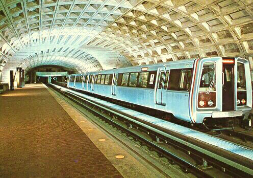 |
Metro Center Station, soon after opening in 1976, from a 1970s post card.
WMATA Baseline System Inventory - 1986 Update
Descriptions of Huntington and Vienna Routes (direct excerpts)
Huntington (C) Route
The Huntington (C) Route begins in subway at the north end of the Metro Center Station (N-S) and proceeds northward under 12th Street, then westward under Eye Street and the Potomac River to the District of Columbia-Virginia boundary.
In Virginia the route passes through Rosslyn southward under Lynn Street to a point south of Arlington Boulevard. The route then continues southward on the surface along the east side of the Jefferson Davis Highway to the vicinity of Washington Boulevard. It then continues southward in subway and curves southwestward around the east and southeast face of the Pentagon and then southward in subway under Hayes Street, then eastward under 18th Street, crossing under the George Washington Memorial Parkway, to the National Airport. The route then turns southward and proceeds through National Airport on aerial structure, crosses over the George Washington Memorial Parkway and continues southward on the surface along the east side of the railroad. The route then continues southward on the surface along the east side of the railroad [CSXT, old RF&P] through Alexandria to a point south of Duke Street, then crosses over the Capital Beltway and Huntington Avenue to a terminus at Huntington. The design of this section allows for the possible future construction of a branch route into the Columbia Pike corridor just south of the Pentagon Station.
The following stations are provided: McPherson Square Station along Eye Street at 14th and at 15th Streets, N.W.; Farragut West Station along Eye Street at 17th and at 18th Streets, N.W.; Foggy Bottom-GWU Station along Eye Street at 23nd Street, N.W.; Rosslyn Station along North Moore Street between Wilson Boulevard and 19th Street; Arlington Cemetery Station along Jefferson Davis Highway at Memorial Drive; Pentagon Station at the southeast face of the Pentagon; Pentagon City Station along Hayes Street between 15th Street and Army-Navy Drive; Crystal City Station along 18th Street at Jefferson Davis Highway; National Airport Station along Smith Boulevard opposite the Airport North Terminal; Braddock Road Station along the railroad at Braddock Road; King Street Station along the railroad at King Street; Eisenhower Avenue Station at Eisenhower Avenue east of Telegraph Road; and Huntington Station at Huntington Avenue and at North Kings Highway east of Telegraph Road. A Service and Inspection Yard (S&I) including a Revenue Collection Facility (RCF) and a Facilities Maintenance Center (FMC) is provided along the Franconia-Springfield (J/H) Route just west of where this route branches from the Huntington (C) Route. A Rail-System Maintenance Facility (R-SMNT) is provided adjacent to the Franconia-Springfield (J/H) Route on Mill Road just west of Telegraph Road in Alexandria, Virginia.
Vienna (K) Route
The Vienna (K) Route begins in subway at a junction with the Huntington Route just south of the Rosslyn Station and proceeds westward in subway under 16th Street and Clarendon Boulevard to Fairfax Drive. The route continues westward in subway under Fairfax Drive to a point west of Glebe Road where it enters the median of I-66. The route continues westward on the surface in the median of I-66 to a terminus at Vienna. The design of this section allows for the possible future construction of a branch route to Dulles Airport in the median of the Dulles Airport Access Road just east of the West Falls Church Station.
The following stations are provided: Court House Station along the south side of Wilson Boulevard at North Veitch Street; Clarendon Station along the south side of Wilson Boulevard at North Highland Street; Virginia Square-GMU Station along Fairfax Drive at North Monroe Street; Ballston Station along Fairfax Drive at North Stuart Street; East Falls Church Station along I-66 at North Sycamore Street; West Falls Church Station along I-66 east of Leesburg Pike (Route 7); Dunn Loring Station along I-66 at Gallows Road; and Vienna Station along I-66 west of Nutley Street. A Service and Inspection Yard (S&I) including a Facilities Maintenance Field Base (FMFB) is provided north of the West Falls Church Station.
The above Vienna Route information was originally published in this article in 1998. The station names on this line and throughout the WMATA Metrorail system, have gradually evolved as local groups have lobbied to have hyphenated names added to the original names. The Roads to the Future author is of the opinion that the original names were more simple and elegant. As of April 2007, these are the station names along the Vienna Route: Rosslyn, Court House, Clarendon, Virginia Square-GMU, Ballston-MU, East Falls Church, West Falls Church-VT/UVA, Dunn Loring-Merrifield, and Vienna/Fairfax-GMU.
Directory of Articles With Photos
Northern Virginia Freeway
and Metrorail Map
Interstate 66 Construction
Vienna Metro Station
West Falls Church Metro Station
Ballston Metro Station
Jon Bell's Photos of Vienna
Station and Pentagon Station
All photos taken by Scott Kozel, except for those on the Jon Bell link.
Legend
VDOT - Virginia Department of Transportation
FHWA - Federal Highway Administration
CTB - Commonwealth Transportation Board
MPO - Metropolitan Planning Organization
HOV - High Occupancy Vehicle
EIS - Environmental Impact Statement
FEIS - Final Environmental Impact Statement
DEIS - Draft Environmental Impact Statement
ROD - Record of Decision
NEPA - National Environmental Policy Act on 1969
WMATA - Washington Metropolitan Area Transit Authority
ARS - Authorized Regional System
Acronyms for the Virginia state highway and transportation department: VDH
from 1927 to 1974. Railroad, aviation and public transportation was added in
1974, and the Department became VDHT. The Department became VDOT in 1986.
-> VDH - Virginia Department of Highways
-> VDHT - Virginia Department of Highways and Transportation
-> VDOT - Virginia Department of Transportation
Copyright © 1998-2007 by Scott Kozel. All rights reserved. Reproduction, reuse, or distribution without permission is prohibited.
By Scott M. Kozel, Roads to the Future
(Created 6-29-1998, updated 4-26-2007)