Baltimore Region Rapid Transit System

The report Baltimore Region Rapid Transit System, Feasibility and Preliminary Engineering, was prepared for The Mass Transit Steering Committee, Regional Planning Council, Baltimore, Maryland, and released in July 1968. The study report received financial aid through a federal grant from the U.S. Department of Housing and Urban Development under section 9 of the Urban Mass Transportation Act of 1964 as amended. The report Baltimore Region Rapid Transit System, Phase 1 Plan, was prepared by the Metropolitan Transit Authority, and released in January 1971.

This map came from Baltimore Region Rapid Transit System, Feasibility and Preliminary Engineering, was prepared for The Mass Transit Steering Committee, Regional Planning Council, Baltimore, Maryland, and released in July 1968.

Click for larger map images: Medium (61K), Large (106K), Extra Large (183K). Use "Back" button to return.


Routes and Stations for 71-mile B.R.R.T.S. System
(These stations and numbers correspond to the above map)

CENTRAL STATION

1. Charles Center


NORTHWEST LINE

SOUTH LINE

2. Lexington Market

13. Inner Harbor

3. Bolton Hill

14. Leadenhall Street

4. Laurens Street

15. Cherry Hill

5. North Avenue (West)

16. Belle Grove

6. Mondawmin

17. Fort Meade Road

7. Cold Spring Lane (West)

18. Friendship International Airport

8. Rogers Avenue

19. Glen Burnie

9. Reisterstown Plaza

20. Marley

10. Milford Mill Road


11. Old Court Road


12. Randallstown


NORTH LINE

SOUTHEAST LINE

21. Monument

32. Market Place

22. Biddle Street

33. Central Avenue

23. North Avenue (North)

34. Patterson Park

24. 29th Street

35. Highlandtown

25. 33rd Street

36. City Hospitals

26. Cold Spring Lane (North)

37. Dundalk

27. Belvedere

38. Merritt Boulevard

28. Anneslie

39. Sparrows Point

29. Towson

40. Eastwood

30. Lutherville

41. Rolling Mill Road

31. Timonium

42. Essex


43. Marlyn Avenue


NORTHEAST LINE

WEST LINE

44. Johns Hopkins Hospital

55. Fremont Avenue

45. Gay Street

56. Fulton Avenue

46. North Avenue (East)

57. Poplar Grove Street

47. Erdman-Sinclair

58. Wildwood Parkway

48. Herring Run

59. Edmondson Village

49. Frankford Gardens

60. Academy Heights

50. Radecke Avenue

61. Catonsville

51. Hazelwood Avenue

62. Rolling Road

52. Overlea

63. Chalfonte Drive

53. Parktowne


54. Joppa-Belair


O


Route Configuration Summary for 71-mile B.R.R.T.S. System

VERTICAL CONFIGURATION

TOTAL SYSTEM

MILES

PERCENT

ON GRADE


SURFACE

8.6

12

CUT

18.4

26

FILL

4.7

7

AERIAL

22.8

32

SUBWAY

16.5

23

TOTAL

71.0

100

STATIONS

63

The Metropolitan Transit Authority was established in June 1969 by Article 64B of the Annotated Code of the State of Maryland, and it was charged with the responsibility of formulating a regional transit system. In conformance with the legislative mandate of Section 9, Chapter 160 of the Statute, which states in part - "The Board shall prepare a plan or plans to meet the transit needs of the District ...", the Board of Directors of the Authority adopted on January 27, 
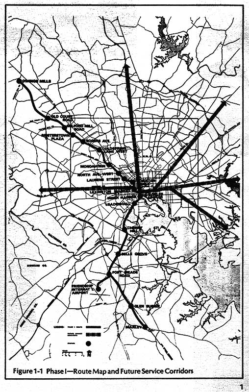
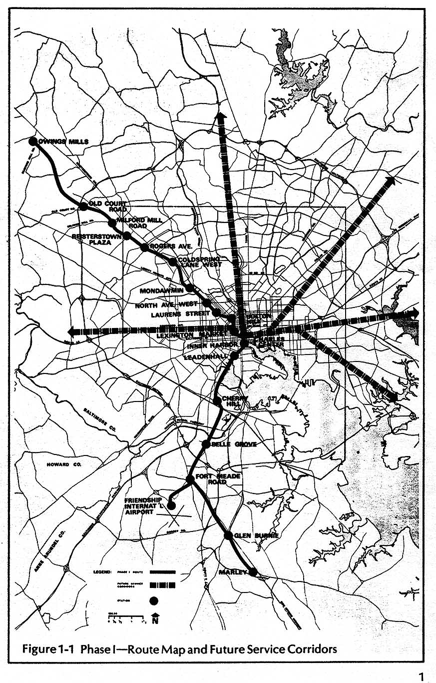
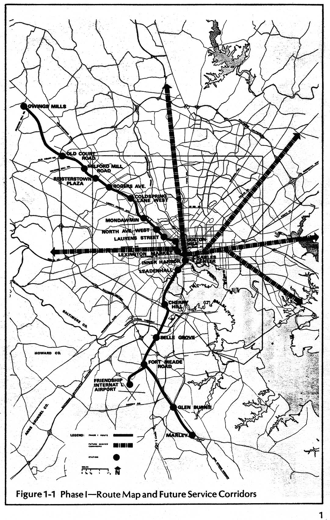
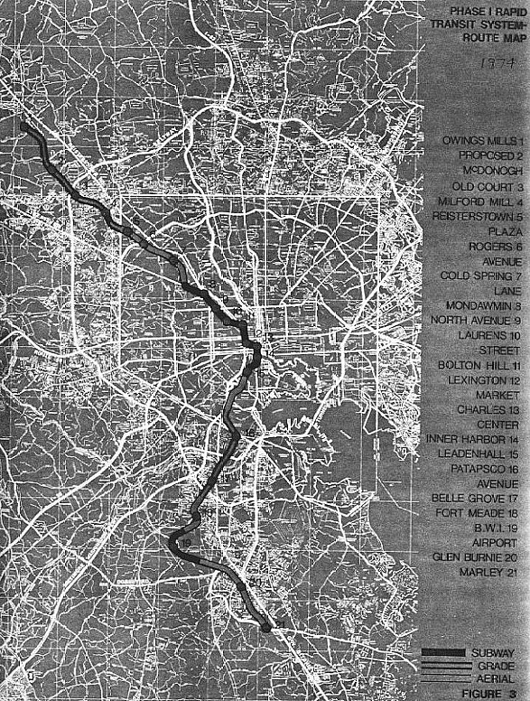
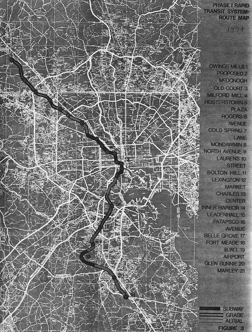
1971, the Phase 1 Rapid Transit System as the official transit plan for the Baltimore 
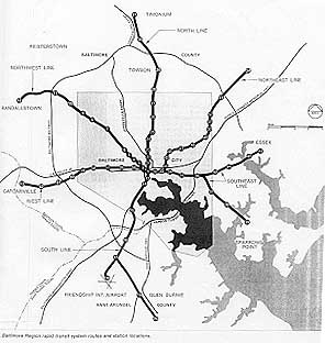
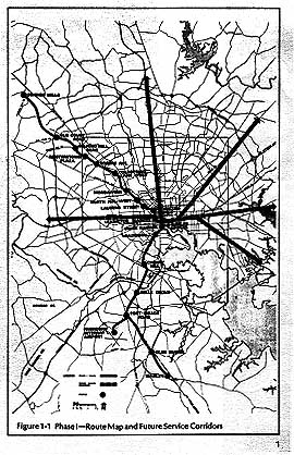
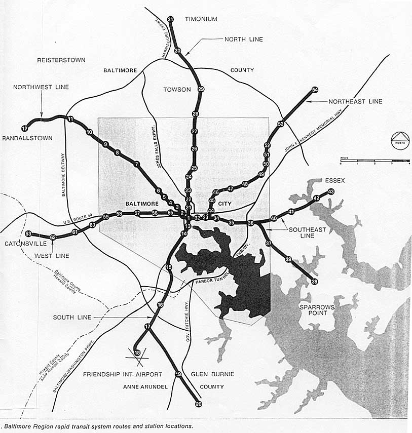
metropolitan area. The Phase 1 Plan used two lines from the 71-mile system, and had a northwest line from the downtown to Owings Mills (terminal revised from the Randallstown terminal in the 1968 report), and a south line from the downtown to Glen Burnie and Friendship International Airport (today's Baltimore-Washington International Airport (BWI)). The two lines in the Phase 1 Plan had a downtown junction at an underground two-level transfer station at Charles Center. The rapid rail transit south line eventually fell victim to funding limitations and local opposition, and the Central Light Rail Line was built along a similar route to that of the once-planned rapid rail south line.

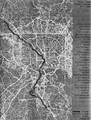
The Phase 1 Plan had 28 miles (44.8 km) of revenue line route and 20 stations, and included all the necessary facilities to provide an operational system, including stations, line structures, passenger rail cars, yards and shops, electrification system, ventilating and heating systems, control and communications systems, automatic fare collection system, and surveillance system. The system vehicles would be steel wheeled, operating on steel rails. The vehicles would operate singly as well as coupled in trains. The rail vehicles would be similar in many respects to the ones that were then being designed for the rapid rail transit systems in the Washington, D.C. area and in the San Francisco, California area. Train service was proposed to run automatically, with most of the system having four-minute minimum headways (train service spacing) during peak hours and ten-minute maximum headways at other times, with service being provided 20 hours per day (5:00 AM one day to 1:00 AM the next day). Predicted ridership for 1980 was 153,000 rail trips on the average weekday. The fare structure would be compatible with the bus fares in use in the Baltimore area. The construction period was proposed to span from 1971 to 1978, and the estimated cost including inflation was $656 million for the preliminary engineering, right-of-way, construction and physical elements needed to make the system operational. Two-thirds of the capital cost, $437 million, was expected to be provided by federal grants from UMTA (U.S. Urban Mass Transit Administration, today's Federal Transit Administration). About 6 miles of line would be underground in subway, with the remainder on the surface or aerial.


This map came from Baltimore Region Rapid Transit System, Phase 1 Plan, was prepared by the Metropolitan Transit Authority, and released in January 1971.


Click for larger map images: Medium (152K), Large (298K), Extra Large (411K). Use "Back" button to return. The largest image has the best detail.

 O


This map is a 1974 version of the Phase 1 Plan. Notice the modification to the south line.


Click for larger map images: Medium (279K), Large (614K). Use "Back" button to return. The largest image has the best detail.

Lead article for Baltimore Metro Subway

Copyright © 1997-2002 by Scott Kozel. All rights reserved. Reproduction, reuse, or distribution without permission is prohibited.

Back to top

By Scott M. Kozel, Roads to the Future

(Created 10-23-2001, updated 10-13-2002)