| Francis Scott Key Bridge (Outer Harbor Crossing) |
Francis Scott Key Bridge (Outer Harbor Crossing)
The Outer Harbor Crossing was the planning name for the 11-mile-long Baltimore Beltway toll facility between MD-10 and MD-151, and it includes the 1.6-mile-long Francis Scott Key Bridge over Baltimore Harbor.
The Key Bridge south main pier was struck by an out-of-control container ship MV Dali on March 26, 2024, and the 2,644 foot long truss structure completely collapsed. An 8-week period ensued for salvage crews to remove the wreckage and reopen the main shipping channel. This article will remain online for history and in its 2006 last update format.
Baltimore Outer Harbor Crossing Replacement Proposal - Roads to the Future article to evaluate the new bridge proposal of the Maryland Transportation Authority (MDTA) and to recommend tunnel alternatives.
Last updated:
The southern, western, and northern portion of the I-695 Baltimore Beltway (with six or more lanes) was completed between MD-2 south of the city and US-40 northeast of the city by 1962. The beltway between US-40 and MD-151 at Edgemere was opened 1973.
The Outer Harbor Crossing, an 11-mile-long toll facility between MD-10 Arundel Freeway and MD-151 North Point Boulevard, was opened to traffic on March 23, 1977, and this completed the Baltimore Beltway. The Outer Harbor Crossing was planned as a two-lane freeway on four-lane right-of-way, with a single-tube two-lane 6,200-foot-long harbor tunnel. The two-lane freeway was placed under construction, the causeways (landfill for roadway across a water body) for the tunnel portals were built, and when the tunnel was advertised for construction in 1970, the bids received on July 30, 1970 were so high that it was determined that a four-lane high-level bridge could be built for about the same cost as the revised estimate for the tunnel project, about $50 million. So the bridge was built, well-known to motorists as the Francis Scott Key Bridge. The prime engineering consultant for the bridge's design was J. E. Greiner Co., Inc., of Baltimore, Maryland. Piers for the high-level approaches were constructed on the causeways and in the harbor. The bridge is 8,636 feet (1.6 miles) long, and the main span of the bridge consists of a continuous steel truss span with 185 feet of vertical navigational clearance and 1,200 feet of span length.
Actually, the design of the 2,644-foot-long central 3-span section of the bridge which has the overhead steel truss structure, is a combination design which includes elements of cantilever, steel truss, arch, and suspension, as most of the roadway length in the 1,200-foot-long main span is a plate girder structure suspended by cables from the steel cantilever arch structure. The two 722-foot-long back spans have the roadway structure integral with the steel truss structure.
Key Bridge substructure contract: An Engineering News-Record magazine article "Substructure under estimate for Baltimore harbor bridge", August 24, 1972, page 16, announced the low bid of $19.5 million for the substructure of the bridge, which was $1.1 million under the engineer's estimate. The substructure contract involved building all the reinforced concrete vertical piers for the bridge, from the foundations up to the tops of the piers. This contract was a joint venture of The Balf Company and Savin Brothers, Inc., both of Bloomfield, Connecticut; and Whaling City Dredge & Dock Corp., of Groton, Connecticut. J. E. Greiner Co., Inc., of Baltimore, Maryland, was cited as the prime engineering consultant for the entire bridge project, as well as the designer of the main piers and the 2,644-foot-long continuous truss structure which includes the 1,200-foot-long main span and two 722-foot-long back spans. The approach spans were designed by Singstad, Kehart, November & Hurka, of New York City, New York; with Zollman Associates, Inc. of Philadelphia, Pennsylvania, and the individual spans range from 200 to 300 feet long. The article mentioned the original two-lane tunnel plan that would have been $15 million more expensive than the four-lane bridge.
Key Bridge superstructure contract: An Engineering News-Record magazine article "High-level bridge bid near estimate", October 19, 1972, page 14, announced the low bid of $30.7 million for the superstructure, which was 5% above the engineer's estimate, by Pittsburgh-Des Moines Steel Company of Pittsburgh, Pennsylvania. Construction industry experts had predicted that the low bidder for the superstructure contract would be the American Bridge Division of U.S. Steel Corp. (Ambridge) of Pittsburgh, Pennsylvania, because they had a large marine fleet that was completing the contract for the parallel Chesapeake Bay Bridge about 20 miles to the south, as Ambridge had assembled many sections of that bridge in its Baltimore yard and barged them to the bridge site, but on the bidding for the Key Bridge superstructure contract, Ambridge was in third place at $32.3 million. The superstructure contract involved building all the spans of the bridge, across the tops of the piers built in the substructure contract. The 2,644-foot-long 3-span continuous truss section of the bridge, the plate girder approach spans, and the reinforced concrete roadway deck, were built under this contract. The three approach spans over water on the west side of the truss structure, and the six approach spans over water on the east side of the truss structure, were designed and built in 300-foot-long one-span units and then installed on the bridge piers, to reduce fabrication costs. The steel erection subcontractor on this contract was John F. Beasley Construction Company of Dallas, Texas. The article also announced the award of the $19.5 million substructure contract to the joint venture of three Connecticut firms, and mentioned that the entire 11-mile-long Outer Harbor Crossing project was fully under construction, with a total projected cost of $136 million. The total cost of the two bridge contract awards (substructure and superstructure) was $50.2 million.
Engineering News-Record magazine had a feature article about this bridge project, "Heavy-lift floating and traveling derricks team to erect truss bridge, January 15, 1976. The article cited Sidney Sherman, project engineer for Greiner Engineering Sciences, Inc., Baltimore, the company which designed the main truss and who was chief consultant to the state for the Key Bridge project, and he said that the company studied using a suspension bridge at the site but rejected that design because of high anchorage costs. He also said that the structure was the longest continuous truss bridge in the U.S.
The administrative agency for the Outer Harbor Crossing is the Maryland Transportation Authority (MdTA). The MdTA Fact Sheet gives $60.3 million as the total cost of the bridge itself, and that would include design engineering as well as construction of the bridge and causeways. It also mentions "the bridge, at an estimated cost of $110 million", but I think that is a reference to the entire 11-mile long highway facility. These figure differences need to be resolved through inquiry to MdTA.
The originally planned two-lane tunnel concept explains why the Key Bridge was built with two-lane approaches. The south approach between MD-10 and the Key Bridge, includes a bridge with a bascule drawspan over Curtis Creek, and the drawspan when closed has 60 feet of vertical navigational clearance over a marine channel; and the whole south approach was built with two lanes and was dualized to four lanes by 1981. The 3.5-mile-long north approach was built as a two-lane elevated viaduct over Bear Creek, and it also skirted the edge of the Sparrows Point Bethlehem Steel complex, and the viaduct when built crossed at least 16 roads and 2 railroads all along the section on Sparrows Point, including the intersection between Bethlehem Boulevard and Dundalk Avenue (the Dundalk Avenue Bridge over Bear Creek has since been closed and removed). Four-lane widening of the Bear Creek Bridge, and elimination of the rest of the viaduct with a ground-level four-lane roadway, and simplification of the MD-151 interchange with Bethlehem Boulevard, and simplification of the Bethlehem Boulevard interchange with Peninsula Expressway, at a total project cost of $89.5 million, was completed by MdTA in January 2000. The large reduction in employment at the Sparrows Point Bethlehem Steel complex in the years after the original beltway segment opened, led to much lower volumes of traffic on the local roads near the original viaduct, allowing some of the local roads to be reconfigured into a simpler design with fewer roads needing to cross the I-695 beltway, and whereas the original viaduct was justified when it was built around 1970 because of the many road and railroad crossings that needed to be passed over, by 1995 a simpler surface-level design was possible with the reconstructed highway between the Bear Creek Bridge and MD-151 North Point Boulevard. The entire eastern portion of the Beltway now has four lanes (two each way) at the minimum. It is unusual for an urban freeway to have had only two lanes for 23 years, but the tremendous capacity (12 lanes) of the two inner harbor crossings (I-95 and I-895) has kept the traffic volumes reasonable on the Outer Harbor Crossing.
Current other major structures along the 11-mile-long Outer Harbor Crossing include 3,379-foot-long (0.64 mile) parallel bridges over Curtis Creek and 3,907-foot-long (0.74 mile) parallel bridges over Bear Creek, near Bethlehem Steel’s Sparrows Point plant. Those mileage figures are from the MdTA Fact Sheet, and then converted to feet.
| Francis Scott Key Bridge - Vital Facts | |
| Bridge design | Steel truss cantilever arch main spans, plate girder approach spans |
| Bridge length | 8,636 feet (1.6 miles) |
| Continuous truss length | 2,644 feet |
| Main span length | 1,200 feet |
| Back span length | 722 feet |
| Vertical navigational clearance under main span | 185 feet |
| Highway class | Freeway, built to Interstate highway standards |
| Highway route | Interstate I-695, Baltimore Beltway |
| Water bodies crossed | Baltimore Harbor and shipping channel |
| Total number of lanes | 4 lanes |
| Speed limit | 55 mph |
| Toll facilities | Electronic tolling plus cash lanes, toll plaza in Dundalk |
| Toll | $2 for 2-axle vehicle, commuter discounts available |
| Administrative agency | Maryland Transportation Authority (MdTA) |
| Design Prime Consultant | J. E. Greiner Co., Inc. |
| Contracting method | Agency public bid contracting, 3 construction contracts |
| Construction Began | August 1972 |
| Substructure prime contractor | Balf/Savin/Whaling City joint venture |
| Superstructure prime contractor | Pittsburgh-Des Moines Steel Company |
| Final cost total for design, right-of-way and construction | $60.3 million |
| Funding method | 100% MdTA toll revenue bonds |
| Facility opened to traffic | March 23, 1977 |
| Traffic Volumes as of December 2005 | Average about 31,000 vehicles per day, 10% large trucks |
.
| Outer Harbor Crossing - Vital Facts | |
| Facility length | 11.3 miles |
| Highway class | Freeway, built to Interstate highway standards |
| Highway route | Interstate I-695, Baltimore Beltway |
| Water bodies crossed | Baltimore Harbor, Curtis Creek, Bear Creek |
| Total number of lanes | 4 lanes |
| Speed limit | 55 mph |
| Toll facilities | Electronic tolling plus cash lanes, toll plaza in Dundalk |
| Toll | $2 for 2-axle vehicle, commuter discounts available |
| Administrative agency | Maryland Transportation Authority (MdTA) |
| Contracting method | Agency public bid contracting |
| Construction Began | 1972 |
| Final cost total for design, right-of-way and construction | $136 million |
| Funding method | 100% MdTA toll revenue bonds |
| Facility opened to traffic | March 23, 1977 |
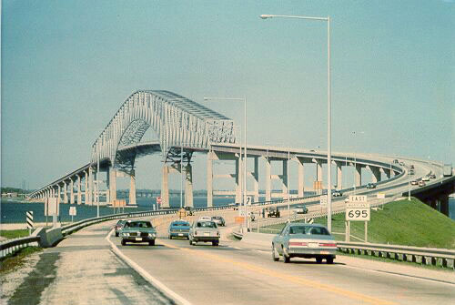
Above, Key Bridge, looking north, taken in April
1978. The south approach was two lanes, and was widened to four lanes by 1981.
Note that the road was MD-695 originally. Notice the safety nets hanging under
main span, as the original painting was finishing up.
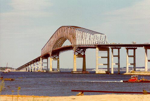
Above, Key Bridge under construction in 1976, looking
north. The Route 695 Sparrows Point Viaduct, and the Bethlehem Steel complex is
in the background. The steel plant is across almost two miles of water from
the photo-shooting point.
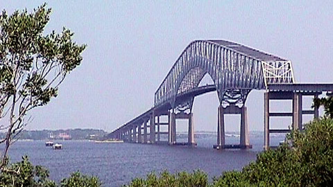
Above, Key Bridge, taken from a similar vantage
point as the previous photo. Photo by Jim K. Georges, July 1999.
This outer crossing of the Baltimore Harbor opened in March 1977 as the final link in I-695 (the Baltimore Beltway). Including its connecting approaches, the project is 10.5 miles in length. In January 2000, the Authority completed an $89.5 million project to replace the northern approach's former two-lane viaduct with an at-grade, four lane roadway. More than 11-million vehicles used the bridge during fiscal year 2001. The toll for a two-axle vehicle is $2; each additional axle is $2. The E-ZPass electronic-toll-collection system is available at the Francis Scott Key Bridge.
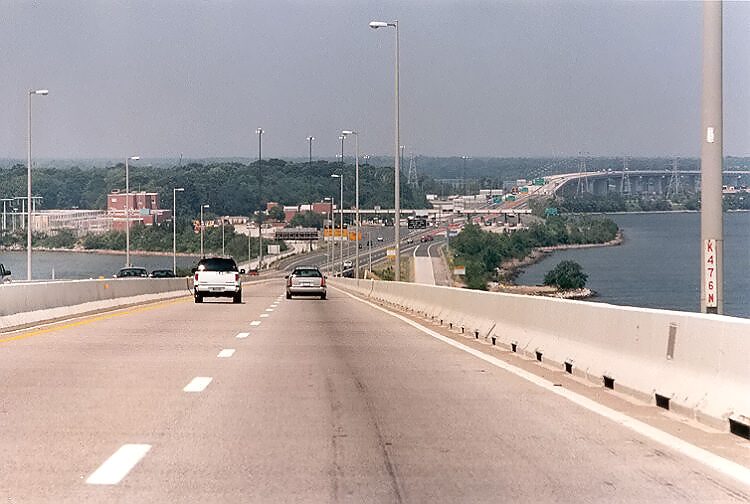
Above, on the Key Bridge, northbound, just north of the continuous truss span, looking toward the toll plaza, and the Bear Creek Bridge (Sparrows Point Viaduct) in the distance. Photo taken July 5, 1999, the Monday that was the holiday for Independence Day in 1999; at about 3:00 PM, near the end of a holiday weekend which is one of the highest interstate travel days of the year. The 3.5-mile-long widening project to widen the 2-lane Sparrows Point section was still under construction. As you can see, the eastern portion of the I-695 Baltimore Beltway has capacity to spare. This should provide an effective I-95 bypass for many years into the future. Click the photo for large image (112K).
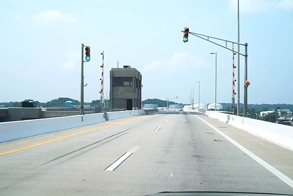
Above, eastbound Curtis Creek Bridge on I-695, on the Outer Harbor Crossing, three miles west of the Key Bridge. This crossing is comprised of twin bridges, each with two lanes, and each with a bascule drawspan with 60 feet of vertical navigational clearance when the drawspan is closed. Click the photo for large image (178K). Photo offered to this website, August 2002, by Rush Wickes of Blacksburg, Virginia.Maryland Transportation Authority link to Francis Scott Key Bridge in 2006. Excerpt (in blue text):
That 2001 traffic volume is an average of about 30,300 per day, well within the capacity of a four-lane freeway.
MdTA Francis Scott Key Bridge Fact Sheet in 2006. Excerpts (in blue text):
By the early 1960s, the Baltimore
Harbor Tunnel (Interstate 895), the first crossing of Baltimore’s Harbor, had
reached its traffic capacity, and motorists encountered heavy congestion and delays
almost daily during rush hours. The State Roads Commission, predecessor of the
Maryland Transportation Authority, concluded there was a need for a second harbor
crossing and began planning a single-tube tunnel under the Patapsco River, downstream
from the Harbor Tunnel. The proposed site was between Hawkins Point and Sollers
Point. Plans also were underway for a drawbridge over Curtis Creek to connect
Hawkins Point to Sollers Point.
Contractors took borings of the harbor bottom in the spring of 1969. Bids for construction of the proposed tunnel were opened on July 30, 1970, but price proposals were substantially higher than the engineering estimates. Officials drafted alternative plans, including the concept of a four-lane bridge. The bridge, at an estimated cost of $110 million, represented the best alternative because it allowed for more traffic lanes and carried lower operating and maintenance costs than a tunnel. In addition, a bridge would provide a route across the Baltimore Harbor for vehicles transporting hazardous materials (these materials are prohibited from both the Baltimore Harbor and Fort McHenry [Interstate 95] tunnels).
About the Maryland Transportation Authority. Excerpt (in blue text):
I-695 Baltimore Beltway Widening - Sparrows Point - Roads to the Future article with three photos of the four-lane widening and elimination of most of the Sparrows Point Viaduct.
Baltimore Harbor Crossings - Roads to the Future article with a photo of the Key Bridge and a photo of the completed widening and reconstruction of I-695 on Sparrows Point.
All photos taken by Scott Kozel except for the two noted.
Copyright © 1997-2025 by Scott Kozel. All rights reserved. Reproduction, reuse, or distribution without permission is prohibited.
By Scott M. Kozel, Roads to the Future
(Created 8-14-1997, updated 9-4-2025)