| Monitor-Merrimac Memorial Bridge-Tunnel (I-664) |
Monitor-Merrimac Memorial Bridge-Tunnel (I-664)
Interstate 664 is the 20.7-mile-long freeway that connects I-64 in Hampton to I-64/I-264 in Chesapeake, completed in April 1992. I-664 includes the 4.6-mile Monitor-Merrimac Memorial Bridge-Tunnel (MMMBT). The MMMBT cost $400 million to build, and it includes a four-lane tunnel that is 4,800 feet long, two man-made portal islands, and 3.2 miles of twin trestle. Northbound on the MMMBT is one of the most spectacular views on any road I know of; Hampton Roads makes a "V" with one branch to your ten o'clock, and the other branch to your two o'clock. You see an enormous expanse of water, left, right, and ahead of you, with the landfall of the Peninsula dead ahead. On the ten o'clock branch, you see the Newport News Marine Terminal and Shipyards, on the two o'clock branch, you see the Norfolk Naval Base. Typically, you will see a couple Nimitz-class aircraft carriers moored in the distance, and many other ships. Another nice feature, is that the MMMBT is toll-free. The name comes from the fact that the duel between the two Civil War ironclads was fought less than a mile from the where the tunnel is today.
"At last, a beltway for Hampton Roads", article by the main Norfolk/Hampton Roads area regional newspaper Virginian-Pilot, April 30, 1992, had this to say (blue text):
The Monitor-Merrimac Memorial Bridge-Tunnel opened this morning three minutes after midnight, completing a highway network begun three decades ago and ushering in rapid economic growth for Western Tidewater. The $400 million project, the largest in the state's history, was dedicated shortly before 3 p.m. Wednesday at a ceremony on the Newport News side of the bridge-tunnel. Pulling a large red lever, Gov. L.Douglas Wilder and former Gov. Mills E. Godwin together switched on an overhead electric sign that read, "I-664 Br-Tunnel makes the connection." "This is a long time coming," said State Sen. Hunter B. Andrews of Hampton, who began his legislative career in 1964, before the $400 million bridge-tunnel was even a line on a map.|
|
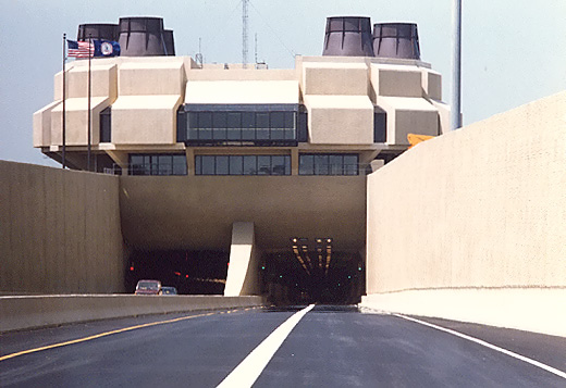
| North portal of the I-664 tunnel, taken in May 1992 soon after opening. |
The tunnel is 4,800 feet long from portal to portal, and it was built by the immersed sunken tube method, comprised of 15 prefabricated segments each 300 feet long and with two 2-lane bores, placed by lay-barges and joined together in a trench dredged in the bottom of the harbor, and backfilled over with earth. Four percent (4%) maximum grades are utilized in the tunnel, and a 60 mph design speed. The traffic lanes in the tunnel are 13 feet wide, with 2.5-foot-wide ledges on either side of the roadway, and with 16.5 feet of vertical clearance from the roadway to the ceiling. The current shipping channel above the deepest part of the tunnel, has 800 feet of horizontal width and 45 feet of vertical depth below the average low-tide water level; and the tunnel was designed and built deep enough to allow for a future enlargement of the shipping channel to 1,000 feet of horizontal width and 55 feet of vertical depth below the average low-tide water level.
|
|
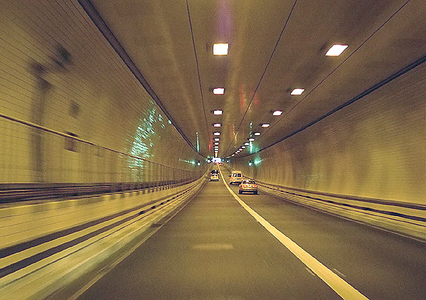
| Near the mid-point of the I-664 tunnel. Photo by Jim K. George in 2002. |
"Building the Monitor-Merrimac Memorial Bridge-Tunnel", article in "Connections: Monitor-Merrimac tunnel closes the loop", Special Section in Daily Press newspaper of Newport News, April 28, 1992, had this excerpt (blue text
): On-site construction of the bridge-tunnel began September 3, 1985, with the construction of the two islands. The north island is not really an island. It is connected to the southern tip of Newport News. Bridge construction from the Suffolk side began on February 13, 1986, and the first of 15 tube sections were placed March 30, 1988. The tunnel is made up of 15 300-foot sections which were placed between March 1988 and June 1989 at roughly the rate of one per month. Construction began with sections 15, 14 and 13 from the Newport News side followed by sections 1, 2 and 3 from the Suffolk side. Section 4 was the last one put in place. The islands required 1.8 million cubic yards of backfill which were hauled from Richmond and almost 1 million tons of stone, brought from Maryland.|
|
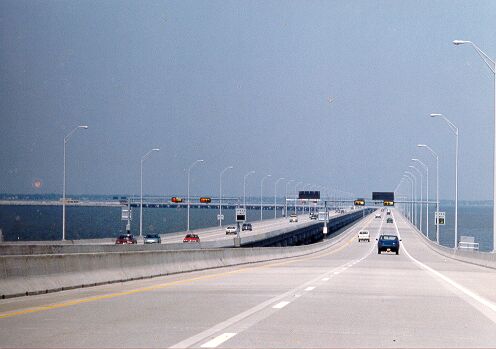
| Northbound on the I-664 South Trestle, taken May 1992, about 1&1/2 mile from the south shoreline of Suffolk, and about 2 miles from the South Island, which you can see in the distance on the left. |
The South Trestle is comprised of twin parallel bridges each 3.2 miles long. Each bridge has two 12-foot-wide lanes, a full 10-foot-wide emergency shoulder on the right, and a 6-foot-wide shoulder on the left. Most of the trestles are on a level grade with the roadways 17.25 feet above the average high-tide water level, and about 1&1/2 mile from the south shoreline, there are higher spans with 25 feet of vertical navigational clearance, to be utilized by a small boat channel. The photo above was taken from near the highest point of the small boat channel span.
|
|
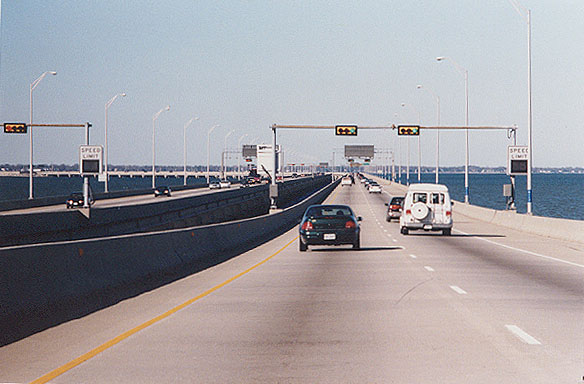
| Northbound on the I-664 South Trestle, about 1&1/2 mile from the south shoreline of Suffolk, and about 2 miles from the South Island, which you can see in the distance on the left. This is nearly the same vantage point as the previous photo, but taken in March 2001 to provide a better rendition. |
The final section of I-664 to open to traffic was the 6.2-mile-long section across Hampton Roads, which included the 4.6-mile Monitor-Merrimac Memorial Bridge-Tunnel, and it opened on April 30, 1992.
The entire MMMBT facility and its approaches have continuous illumination, with variable illumination in the tunnel. There is a traffic control system that is controlled from a central traffic control center, and there are 20 closed circuit television cameras covering the facility and its approaches, and there are television monitors for each camera in the central traffic control center. There are 34 variable message signs along the highway. The roadway has periodic sensors in the pavement that provide a data link to the central traffic control center. A computerized information system controls the traffic control operations.
"One More Crossing, One Less Headache", by the main Norfolk/Hampton Roads area regional newspaper Virginian-Pilot, April 29, 1992, had this to say (blue text):
Just after midnight tonight, South Hampton Roads will be several miles closer to the Peninsula. With the opening of the Monitor-Merrimac Memorial Bridge-Tunnel on Interstate 664, people in Newport News and Suffolk suddenly will be next-door neighbors. Motorists can breeze between the two cities in about 10 minutes. The $400 million crossing will be dedicated at 2 p.m. today on the north island of the bridge-tunnel by Gov. L. Douglas Wilder. The ceremonies, on the Newport News end of the bridge-tunnel, are public. Parking space is limited. Before midnight, I-664 motorists who want to be in the first wave to cross will be allowed to line up at Terminal Avenue in Newport News and at College Drive in Suffolk; but drivers may be turned away if the line grows too long, said Deborah R. Kallgren, a spokeswoman for the state Transportation Department. The largest road project in Virginia history, I-664 will benefit everyone from Virginia Beach to Williamsburg, highway officials say. Drivers headed down the Peninsula to the Outer Banks of North Carolina, for instance, should get relief from long lines at the Hampton Roads Bridge-Tunnel and the James River Bridge. Motorists from the Kempsville section of Virginia Beach traveling to the Peninsula should save time by using I-664 any time the backup at the old bridge-tunnel is longer than 25 minutes - a frequent occurrence.The article went on to say that the facility dedication would be at 2 p.m. the next day, with ceremonies open to the public at the north entrance to the tunnel in Newport News, and that the facility would fully open shortly after midnight. It went on to say that all of Interstate 664 between I-64 in Hampton and I-64 in Chesapeake cost $700 million to build, including $400 million for the Monitor-Merrimac Memorial Bridge-Tunnel. The bridge-tunnel was expected to carry 30,000 vehicles a day when it opens, and 60,000-70,000 a day by 2010. The walls are covered with 3 million 4-inch-square tiles, enough to adorn 6,000 average-sized bathrooms. The entire bridge-tunnel contains about 408,000 tons of concrete and 21,800 tons of steel.
"One More Crossing, One Less Headache", went on to say (blue text):
About 30,000 motorists a day are expected to eventually use the new crossing -- including many who used the [I-64] Hampton Roads Bridge-Tunnel and the [US-17] James River Bridge. That should make life easier at those chokepoints. By the end of the decade, though, traffic at the Hampton Roads Bridge-Tunnel is expected to be just as bad as it is now. By 2010, highway officials predict, 60,000-70,000 vehicles a day will use the state-of-the-art I-664 crossing. This will be near full capacity. Planners already are studying the idea of yet another Hampton Roads crossing, State Transportation commissioner Ray D. Pethtel said.Official VDOT figures for MMMBT average daily traffic volumes in 2000 show just over 44,000 with 8% large trucks.
10-Year Anniversary for Monitor-Merrimac Memorial Bridge-Tunnel
"Monitor-Merrimac tunnel marks its 10th anniversary",
The Virginian-Pilot, April 30, 2002,
had these things to say about the 10-year anniversary of the MMMBT (excerpts in
blue text):
It used to be
known as the best-kept secret in Hampton Roads. But the Monitor-Merrimac Memorial
Bridge-Tunnel, which turns 10 years old today, is getting busier all the time.
Despite its slow start, the Monitor-Merrimac, known as the M&M to regular users, has done what it was supposed to do: provide relief to the Hampton Roads Bridge-Tunnel during peak periods and improve transportation connections to the western edge of the region. "What we'd experience at the Hampton Roads Bridge-Tunnel if we didn't have the Monitor-Merrimac would be indescribable today,'' said Dwight Farmer, deputy executive director for transportation of the Planning District Commission. "It probably would have maxed out completely five to seven years ago.'' In the next month, two more of the region's tunnels will celebrate anniversaries. The Midtown Tunnel is turning 40 and the Downtown Tunnel will be 50. "Think of Hampton Roads without them,'' Collins said. "We would not have come together as one regional economy..... The southside wouldn't have grown. We would
have been an isolated entity -- very difficult to get to.'' In Suffolk, where the south end of the Monitor-Merrimac meets the shore, there's been "a huge impact,'' said Thomas A. O'Grady, economic development director.The Monitor-Merrimac, named after the two ironclad ships that clashed in the Hampton Roads harbor during the Civil War, opened on April 30, 1992. It took seven years and $400 million to build. Planning for the new span began when it became clear that the Hampton Roads Bridge-Tunnel was approaching capacity, just as a third bridge-tunnel is being planned now because of traffic projections on the Monitor-Merrimac.
Although the Monitor-Merrimac hasn't led to a sustained dip in traffic counts on the Hampton Roads Bridge-Tunnel, as originally hoped, it has prevented a near shutdown of the older span.
Regarding the 10-year anniversary of the MMMBT, in VDOT's news release "Monitor-Merrimac
Memorial Bridge-Tunnel Celebrates 10th Anniversary", April 23, 2002, VDOT
wrote (excerpts in blue text):
The Monitor-Merrimac Memorial
Bridge-Tunnel, a vital connection on I-664 between the Southside and the Peninsula,
will celebrate 10 years of connecting communities in Hampton Roads on April 30,
2002. The four-lane Monitor-Merrimac stretches across a four-mile reach of water
at the mouth of the James River. This tunnel is the newest of four operated by
the Virginia Department of Transportation in Hampton Roads and consists of a mile-long
underwater tunnel and three miles of bridge trestle. At the time of opening, the
Monitor-Merrimac Memorial Bridge-Tunnel project cost a total of $400 million and
took around seven years to construct. The cost of fabricating the tunnel and lowering
it into place was about $126 million.
The Monitor-Merrimac Memorial Bridge-Tunnel is named for two ironclad ships that fought in the Hampton Roads harbor during the civil war on March 8-9, 1862. The battle took place between the USS Monitor and the CSS Virginia, formerly known as the Merrimac.
The VDOT news release goes on to cite traffic statistics for the MMMBT. In 1993 (first full year of operation), the average daily traffic count was 26,180, and in 2001, the average daily traffic count was 46,984. In 2004 the average daily traffic volume is over 49,000.
I have an article with two Aerial Photos of the I-664 MMMBT:
Monitor-Merrimac Bridge-Tunnel - Aerial
Photos.
Sources: I-664 Final Environmental Impact Statement, prepared for Virginia Department of Highways, approved by USDOT on September 17, 1973. Location Hearing Information brochure, which was distributed to the public by the Virginia Department of Highways, for the Location Public Hearings which were held March 13 and 14, 1973, on the north and south sides of Hampton Roads respectively. Route 664 Design Study Report, which was distributed to the public by the Virginia Department of Highways and Transportation, for the Design Public Hearings which were held in December 1978. Newspaper articles as cited above.
My material and all photos Copyright © 1997-2004 by Scott Kozel, all photography by same. All rights reserved. Reproduction, reuse, or distribution without permission is prohibited.
By Scott M. Kozel, Roads to the Future
(Created 8-14-1997, last updated 9-12-2004)