
| Monitor-Merrimac Bridge-Tunnel - Aerial Photos |
Monitor-Merrimac Bridge-Tunnel - Aerial Photos
If you had this view on March 9, 1862, you would witness the two ironclads slugging it out in the historic battle between the world's first two ironclad warships. The U.S.S. Monitor fought to a draw with the C.S.S. Virginia, after the Confederate ship destroyed two Union frigates in this same area the day before. The C.S.S. Virginia was built on the hull of the sunken Union ship U.S.S. Merrimac. Despite the renaming of the ship by the Confederacy, the battle has most popularly been remembered by Americans as "The Battle of the Monitor and the Merrimac". During construction, the facility here was named the James River Bridge-Tunnel. Soon before opening, officials named it after the historic battle.
Here is a fine website about the battle, Battle of the Ironclads (Hampton Roads). Another website with music files, Poetry and Music of the War Between the States. Also, The Mariners' Museum - USS Monitor.
|
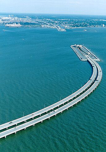
Monitor-Merrimac
Memorial Bridge-Tunnel (I-664), looking north.
The curving 3.2-mile-long South Trestle is in the foreground. That connects to the South Island, where the south tunnel portal is, for the 4,800-foot long tunnel. The North Island and Newport News are in the distance. Starting at the left edge of the photo is the Newport News Marine Terminal. Photo by Virginia Department of Transportation. Click on photo for larger photo (149K); click on larger photo for even larger photo (227K). |
.
|
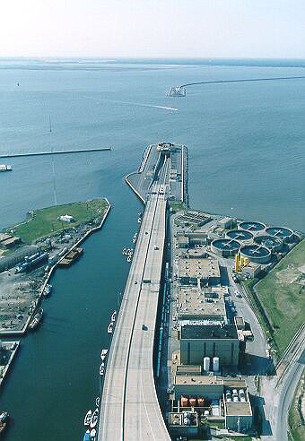
Monitor-Merrimac
Memorial Bridge-Tunnel (I-664), looking south from near the tip of Newport
News.
In the foreground, you can see the North Approach Bridge, and the Small Boat Harbor to the left. The North Approach Bridge connects to the North Island (actually a peninsula) where the north portal of the tunnel is. In the distance, you can see the South Island and the South Trestle. Photo by Virginia Department of Transportation. Click on photo for larger photo (150K); click on larger photo for even larger photo (221K). |
Lead article for
Monitor-Merrimac Memorial Bridge-Tunnel (I-664).Copyright © 1997-2004 by Scott Kozel. All rights reserved. Reproduction, reuse, or distribution without permission is prohibited.
By Scott M. Kozel, Roads to the Future
(Created 10-24-1997, last updated 6-15-2004)