
| Interstate 81 and Interstate 77 |
The 325-mile-long I-81 was essentially complete in Virginia by 1968. There were two incomplete sections totaling 19 miles that were served by rural four-lane highways. A 14.4-mile section near Christiansburg was completed in 1971, and 4.69 miles in the overlap with I-77 was completed in 1987. I-81 was completed in Tennessee around 1975. At that time (1975), I-81 was essentially complete from Tennessee to Canada.
I-77 was not completed in Virginia until 1987. The mostly two-lane West Virginia Turnpike was upgraded to four-lane interstate standards by 1987, and it became I-77. The year 1995 marked the completion of I-77 from I-26 at Columbia, SC to Cleveland, Ohio. I-64 was completed from Lexington to Clifton Forge in 1979, completing I-64 in Virginia.
I-77 in Virginia was routed through mountainous terrain, and followed the US-52 corridor, which seemed to be the path of least resistance. There are two mountain tunnels on this route, the Big Walker Mountain Tunnel near Bland and the East River Mountain Tunnel near Bluefield. Each is a four-lane twin-tube tunnel. The East River Mountain Tunnel, 5,412 feet long, has its south portal in Virginia and its north portal in West Virginia; one of only two places in the U.S. where a mountain tunnel crosses beneath a state border. The new Cumberland Gap tunnel (opened Oct. 1996) runs from Tennessee to Kentucky, barely missing the corner of Virginia about 1/3 mile away. The East River Mountain Tunnel was constructed by Virginia, funded by both states, and is operated by Virginia. There's something else uncommon about the two I-77 tunnels, they both permit motorists to change lanes while inside them.

Above, south portal of the 4,229 foot long Big
Walker Mountain Tunnel. Picture taken Jan. 1991. Little Walker Mountain, about
2 miles south, was crossed by an open cut over 300 feet deep, and over 5 million
cubic yards of earth was moved. An open cut was considered at Big Walker Mountain,
but it would have been about 500 feet deep, with 12 million cubic yards of excavation.
Sources on tunnel information: Virginia Department of Transportation (VDOT) news releases.
"The Big Walker Tunnel (1967-1972)", from The History and Heritage of Civil Engineering in Virginia, by J.C. Hanes and J.M. Morgan, Jr., 1973, Virginia Section of American Society of Civil Engineers.
The Tunnels of Bland County, and The East River Mountain Tunnel and Building the Tunnel, and Charles Fore, Maintenance Supervisor of tunnel, by the Bland County History Archives.
Interstate 77 delivered new world to region / Locals can go, tourists pass through, by Richmond Times-Dispatch, Virginia Century Series, Sunday, June 13, 1999.
U.S. 11 is memory lane / It's the Main Street of many valley towns, by Richmond Times-Dispatch, Virginia Century Series, Sunday, June 13, 1999.
I-77 makes a seven-mile hillclimb of over 2,000 feet, commencing at the North Carolina border, with a third northbound truck-climbing lane. The top of the climb on I-77 is a summit called Fancy Gap, and is over 3,000 feet elevation. The section from NC to the interchange a couple miles north of Fancy Gap was opened in 1977. The northern 6 miles of this section traverses heavily mountainous terrain, and involved over 18 million cubic yards of excavation, making it one of the largest excavation projects in the history of the Interstate system. Southbound on the long grade, there are 3 emergency escape ramps for runaway trucks.
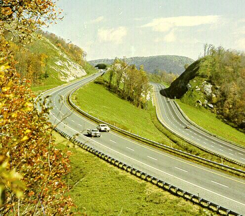
Above, I-77 near Fancy Gap. Photo by Virginia Department
of Transportation, about 1980.
The I-81/I-77 overlap was upgraded to six-lane interstate standards and completed in 1987. I have VDOT location and design planning brochures that showed evaluation of several different alignments, and one of them would have put I-77 on its own alignment (no overlap), a couple miles north of I-81. The overlap alternative was chosen because of lower cost, and better service to the nearby towns.
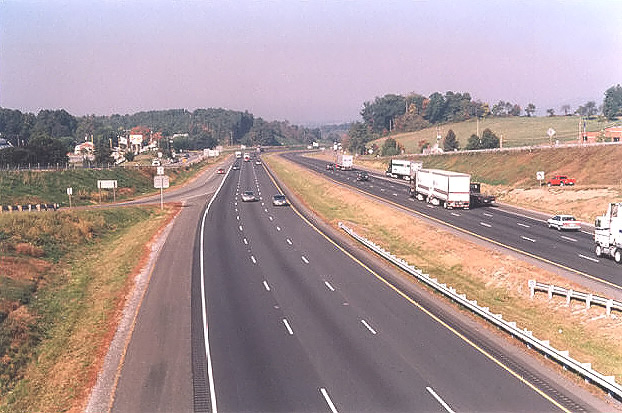
Above, looking west from the overpass near VA-758
and the state police headquarters (Exit 77), I-81/I-77 in Wythe County. Photo
taken 10-5-01.
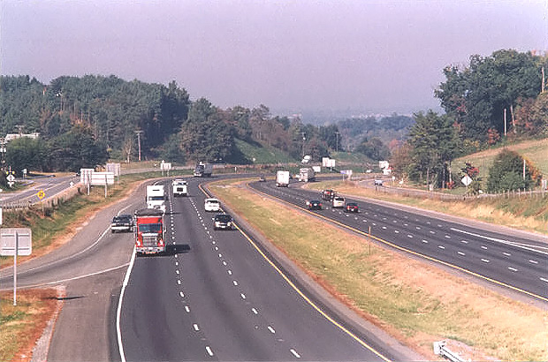
See telephoto (135mm, 2.7x) image from the same vantage point, where the parallel service roads are easier
to see. Photos taken by Scott Kozel.
I-77 makes a jog across 8.01 miles of I-81; they are both north-south interstates, I-81 in western Virginia happens to run east-west for a long stretch; the jog happens to cause the directional signing to run in opposite directions.
Widening of I-81 in Virginia
Studies are underway to widen the entire 325 miles of I-81 in Virginia. VDOT had a plan to widen the highway to a minimum of six lanes, with about 75 miles of eight-lane widening in urban areas such as Roanoke, Harrisonburg, Staunton and Winchester, and in 1997 it was estimated to cost a total of $3.3 billion for engineering, right-of-way and construction, to be completed in phases by 2020.
In January 2002, a private consortium proposed under PPTA (Virginia's Public-Private Transportation Act of 1995), to fund and build the widening program.
In March 2004, I separated the I-81 widening material from this article and put it into a new website article, and the link follows:
Widening of Interstate 81 in Virginia
My Articles with Additional Information and Photos
Interstate 77 Virginia
Photos
Interstate 77 New River Bridge
Interstate 77 in Virginia
Interstate 81 in Virginia
Copyright © 1997-2005 by Scott Kozel. All rights reserved. Reproduction, reuse, or distribution without permission is prohibited.
By Scott M. Kozel, Roads to the Future
(Created 8-20-1997, updated 2-13-2005)