Richmond Beltway (I-295 and VA-288)

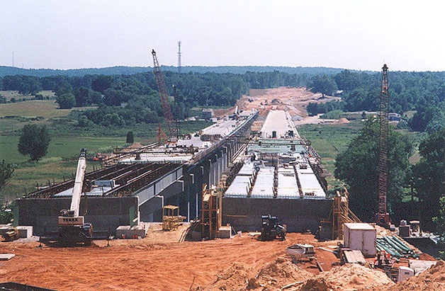
Routes I-295 and VA-288 are freeways which comprise the beltway around Richmond, Virginia, and Route 895 is effectively part of this network. Construction began in May 2001 for all the remaining projects to complete the western portion of VA-288.

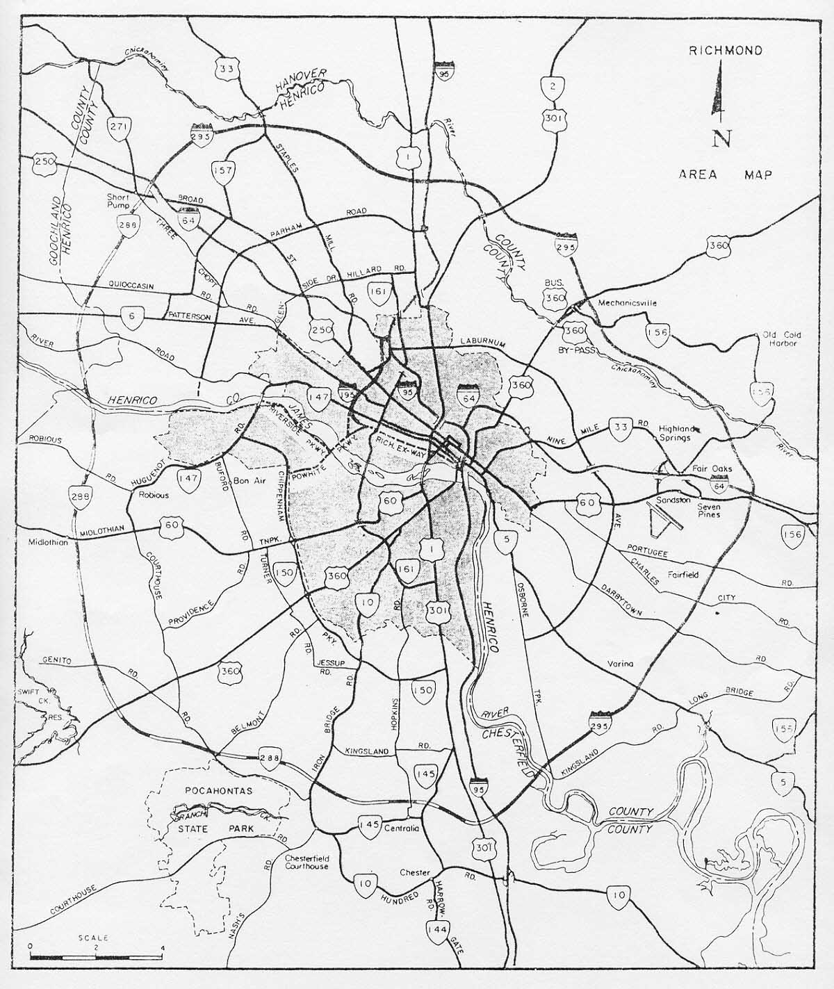
I-295 was conceived as part of the National System of Interstate and Defense Highways which was approved for 41,000 miles of routes in 1956. There were later additions, but I-295 was part of the original 1956 system. It's proposed routing was from I-64 west of Richmond, passing north and east of Richmond, to I-95 south of Richmond just north of Chester, with its southern end actually at US-1/US-301 a mile west of I-95. As an Interstate highway it qualified for 90% federal funding from the Federal Highway Administration (FHWA).

The following named report was the 1968 major thoroughfare plan for the Richmond area: Richmond Regional Area Transportation Study, Volume 5 "Recommended Thoroughfare Plan - Street Inventory, Functional Plans, and Cost Estimates", engineering report prepared in cooperation with Richmond Regional Planning Commission, City of Richmond, Henrico and Chesterfield Counties, Richmond Metropolitan Authority, Virginia Department of Highways, U.S. Department of Transportation, Federal Highway Administration, Bureau of Public Roads, and the U.S. Department of Housing and Urban Development. Prepared by consultant Wilbur Smith and Associates, 1968.

See my article "Richmond Interstates and Expressways", and the section "1968 Major Thoroughfare Plan" for more details, including a Richmond regional map with the proposed highways, including a more detailed map of the Richmond Beltway as then proposed.

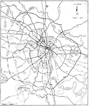
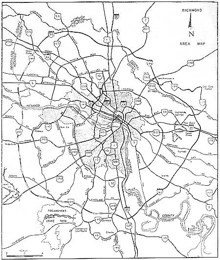
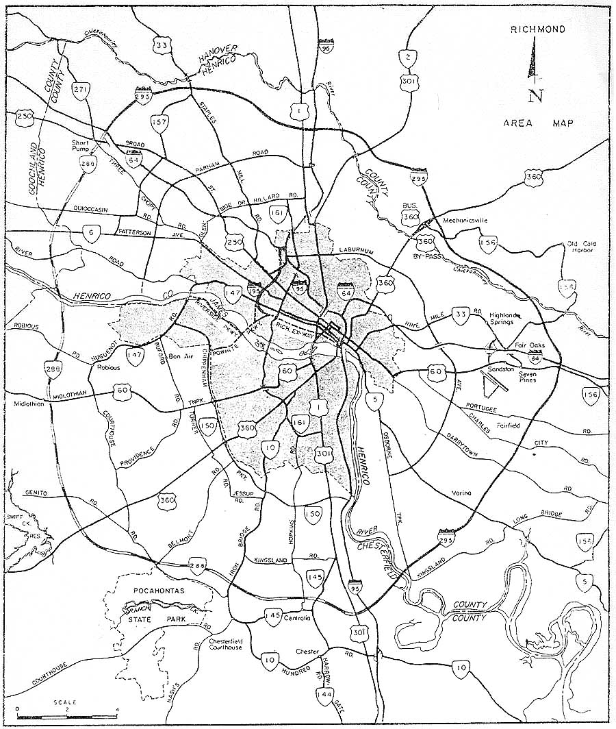
In this 1968 report, the entire Richmond Beltway was shown proposed as a complete circumferential freeway around the region. The portions north of I-64 and east of I-95 were proposed as I-295, and the portions south of I-64 and west of I-95 were proposed as VA-288. I-295 from I-64 west of Richmond to VA-5 southeast of Richmond was ultimately built on essentially the same location shown on this report. The section from VA-5 to I-95 at Dutch Gap was cancelled and not built, because of unacceptable parkland impacts on the Richmond National Battlefield parkline along the battlefield road; this section would have included a fixed high-level bridge with about 150 feet of vertical clearance over the James River at Kingsland Reach. Instead, in 1978, Virginia received approval from FHWA to build the remainder of I-295 south of VA-5 along the location that it occupies today; this alignment avoids any Civil War historical resources, and it extends 22 miles from VA-5 southward to I-95 south of Petersburg, including direct access to the city of Hopewell.

In this 1968 report, the 17.4-mile-long southern portion of VA-288 was shown in the location that it was ultimately built from 1986-1989; from I-95 to VA-76 (although VA-76 Powhite Parkway had a planned western termini at US-60/Robious Road in that report). The western portion of VA-288 was shown extending from today's VA-288/VA-76 junction, through Midlothian, to the junction of I-64 and I-295 west of Richmond. After location studies in the 1970s, these route locations were approved by the Virginia State Highway Commission.

The proposed location for the western portion of VA-288 was abandoned by the Commonwealth Transportation Board (former VSHC) in 1988, due to extensive later development along portions of the route in Chesterfield and Henrico Counties (28 businesses along US-60 in Midlothian would have been razed by the original location); that is when the present western location of VA-288 was approved by the CTB, and this location passes through the eastern corner of Powhatan County and the eastern portion of Goochland County, interchanging I-64 about 1/2-mile west of the Goochland/Henrico County Line. In Goochland County, the private developer of the West Creek development offered 3.5 miles of right-of-way, free of charge, to VDOT, for the portion of VA-288 that passes through their property, and VDOT accepted the donation of the right-of-way. The western portion of VA-288 is scheduled for completion in mid-2004. A 4-lane arterial highway location was also approved by the CTB in 1989, the John Rolfe Parkway, as an extension from I-295 southward from I-64 to Gayton Road. About 1.2 mile of the John Rolfe Parkway has been built from Gayton Road to Ridgefield Parkway, but most of the parkway remains unbuilt.

This map showing the I-295 and VA-288 Richmond Beltway as envisaged in 1973 came from Final Environmental/Section 4(f) Statement Administrative Action for Interstate Route 295, Chesterfield, Hanover and Henrico Counties, by Virginia Department of Highways, Environmental Quality Division, in cooperation with U.S. Department of Transportation, Federal Highway Administration, May 1973.

Click for larger map images: Small (81K), Medium (120K), Large (232K), Extra Large (286K). The largest image is the best one for clearly seeing the route numbers. The map that I scanned is a copy of a copy, so the quality is a bit reduced. Use "Back" button to return.

So this shows how the full continuous Richmond Beltway was broken in two places, necessitating travel on other freeways to follow the circumferential. One of the proposals in the late 1970s showed a direct freeway connection from I-95/VA-288 at Dutch Gap to I-295 south of the James River; this would not have crossed the river, but it would have had major wetland impacts. Building this would provide a VA-288 extension from I-95 to I-295, closing this link in the beltway, but there are no such plans today; in recent years the extensive Rivers Bend housing developments just west of I-295 now provides an obstacle to such a route. The highways I-95 and VA-10 provide the beltway connection here; even though the 3.9-mile-long section of VA-10 is not limited access, it is a high speed divided arterial, and part (2.0 miles) was recently widened to 6 lanes divided, with the remainder still 4 lanes divided, but is planned for 6-lane widening in the near future. The Route 895 Pocahontas Parkway also provides a beltway route in this general corridor.

The entire I-295 is 52.6 miles long. I-295 provided an outer Richmond freeway bypass for east-west I-64 traffic when the 24.7-mile-long northern portion of I-295 was completed in 1981 at a cost of $200 million, as well as an outer Richmond freeway bypass for traffic between I-95 north of Richmond and I-64 east of Richmond.  I-295 provided an outer Richmond-Petersburg freeway bypass for north-south I-95 traffic when the 27.9-mile-long eastern portion of I-295 was completed in 1992, at a cost of $250 million. All of the projects (design, right-of-way acquisition, and construction) were administered by VDOT.

Interstate 295 in Virginia - my article with more details about I-295 such as opening dates, traffic volumes and number of lanes by section, and the improvements to the eastern and western I-64/I-295 interchanges.

Richmond-Petersburg Turnpike (I-95/I-85) and I-295 - my article that includes discussion about the decision to extend I-295 to I-95 south of Petersburg, and includes discussion and photos of the cable-stayed Varina-Enon Bridge, which is the I-295 crossing of the James River.

Route 895 is 8.8 miles long, and it was completed in September 2002 at a cost of $314 million, and it is tolled and it was financed by public-private funding, and it was the last missing link in the regional Interstate beltway, the connection between I-95 north of Richmond and I-85 south of Petersburg; formerly, the through traffic needed to follow I-95 and I-85, passing through downtown Richmond, if it wanted to stay on Interstate highways. Likewise, Route 895 also filled the Interstate beltway function of providing a Richmond freeway bypass for traffic traveling between the I-85 corridor and the section of I-64 from east of Richmond to Williamsburg; formerly, the through traffic needed to follow I-95 and I-64, passing through downtown Richmond, if it wanted to stay on Interstate highways. Construction began in October 1998 on the Route 895 connector between I-95 and I-295; and it opened in September 2002, so now the I-95/I-85 traffic has a beltway bypass around Richmond, using Route 895 and I-295, and the I-85/I-64 East traffic has a beltway bypass around Richmond, using I-95, Route 895 and I-295.

See my Route 895 - Pocahontas Parkway article for a 1983 map of what the beltway system looked like as then proposed. At that point, the Dutch Gap section had been cancelled, and the planned western portion of VA-288 was still in its originally planned route between VA-76 and I-64/I-295. I have all the details about Route 895 in that article.

Construction on the 17.4-mile-long southern portion of VA-288 in Chesterfield County was completed in 1989 at a cost of $102 million. The construction sequence follows. The 2.8 miles of VA-288 between US-360 and VA-76 was funded and built as a part of the toll revenue bond financed Powhite Parkway Extension program, and VA-288 is toll-free, and it opened to traffic in November 1988. Legislation of the General Assembly in 1983 (Senate Bill 304) provided for an extension of tolls on the Richmond-Petersburg Turnpike until 1992, and the usage of the toll revenues for five local road projects. One of the projects funded via S.B. 304 was the 6.5 miles of VA-288 between VA-10 and US-1/US-301 in Chesterfield County. The 7.2 miles of VA-288 between US-360 and VA-10 was funded by a Chesterfield County bond issue. The 0.9 mile of VA-288 between US-1/US-301 and I-95 was funded by conventional state and federal highway trust funds. The westerly ramps at the VA-288/VA-76 interchange were opened in January 1994, funded by conventional state and federal highway trust funds, and the portion of Powhite Parkway west of VA-288 is toll-free. All of the projects (design, right-of-way acquisition, and construction) were administered by VDOT. So it can be seen that four different types of funding was utilized to build the 17.4-mile-long southern portion of VA-288. This is an excellent example of innovative financing of highway projects.

Construction of Western Portion of Route 288

Construction on the 17.5-mile-long western portion of VA-288 is well underway, and is heading for an mid-2004 completion date. The entire VA-288 highway will be 34.9 miles long. Route 288 will have no tolls and will be known as the World War II Veterans Memorial Highway.


Above, looking south, photo taken by Scott Kozel in early June, 2002, construction of the 3,642-foot-long VA-288 James River Bridge. At that point, all of the bridge columns had been built, all of the pier caps on top of the columns had been built, the north abutments had just been completed, the last beams had been placed, and roadway deck construction was nearing completion on both bridges. The bridges were completed in August 2002. The bridge is of a concrete girder design (steel girders for the over-river spans), with two spans each with two lanes and full right shoulders. I'm standing in Goochland County and on the opposite side of the river is Powhatan County. The James River is about 200 feet wide at this point. The length of these bridges is dictated by the large flood plain of the James River, since a large flood such as the ones associated with Hurricane Camille in 1969 and Hurricane Agnes in 1972 (downgraded to tropical storms by the time that they dumped huge amounts of rainfall in the western part of Virginia), can cause this section of the river to rise 20 to 25 feet above flood stage.

Detailed information about the construction of the western portion of Route 288, along with the links to the monthly construction updates, is on a separate website article:
Route VA-288 Construction - Western Section

Copyright © 1999-2004 by Scott Kozel. All rights reserved. Reproduction, reuse, or distribution without permission is prohibited.

Back to top

By Scott M. Kozel, Roads to the Future

(Created 3-27-1999; last updated 3-1-2004)