In the July 10, 1998
Richmond Times-Dispatch, there was an article
"$350 million in bonds sold to finance I-895". Excerpt (blue text):
The private firm
hired to build Interstate 895 announced yesterday that it had sold $350 million
in bonds to finance the project. Construction of the four-lane, 8.8-mile toll
road, which has been planned for more than 15 years, is scheduled to start as
early as October, with completion by 2002. Right-of-way acquisition will begin
immediately.
The construction start was announced in this article in the October 13, 1998,
Richmond Times-Dispatch, excerpt (blue text):
Dig frees treasures from slave site /
Wilton excavation required for Route 895 project. [...]
In a matter of months, the land will be taken by Route 895, a four-lane toll
road connecting Interstate 95 in Chesterfield County with I-295 in Henrico. State
officials will celebrate the start of the highway's construction at Wilton today.
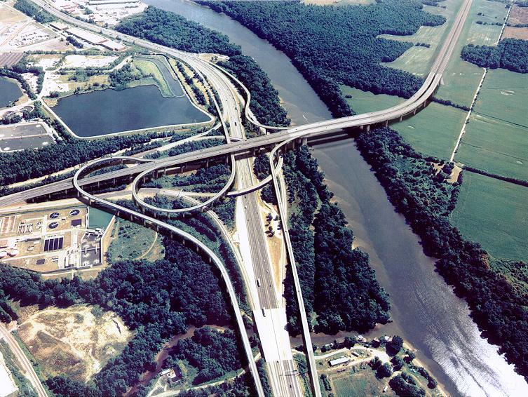
Route 895 has a 4,765-foot-long high-level James River bridge similar in scale
to the I-295 Varina-Enon Bridge,
since large ships need access to the Port of Richmond (former Richmond
Deep Water Terminal), which is upstream of both bridges. The cost figure for the
bridge portion is close to $200 million, and there are complex elevated ramps
at the I-95 interchange, since the river is right next to it. Interchanges
were built also at Laburnum Avenue and at I-295, and there are high-speed ramp
connections to and from I-295 to the north.
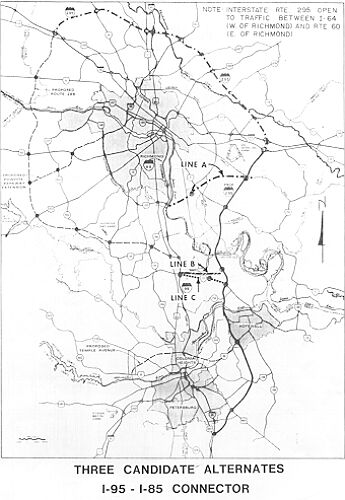
Roads to the Future article Richmond-Petersburg
Turnpike (I-95/I-85) and I-295 has a photo of the cable-stayed Varina-Enon
Bridge.
The Route 895 Connector was almost entirely funded by private capital under
the PPTA (Public-Private
Transportation Act of 1995).
From VDOT Route 895 page, showing projections as of early 1998, excerpt
(blue text):
Anticipated
cost of the Route 895 Connector is $324 million. Virginia will provide a total
of $27 million ($18 million in loans from the State Infrastructure Fund and $9
million in design cost). The remaining $297 million will be generated by private
bond investors. The investors and the state will be repaid solely by tolls from
users of the parkway.
Opening of Route 895 Pocahontas Parkway
VDOT opened the first phase of Route 895 on Wednesday, May 22, 2002. The westbound
main span of the James River Bridge was still under construction then, as was
Ramp H which connects westbound Route 895 to northbound I-95; and it was September
before they were completed. The rest of Route 895 opened on May 22, 2002. So in
May, the entire eastbound 8.8 miles of Route 895 from VA-150 and I-95, to I-295,
was open; and the section of westbound Route 895 from I-295 to Laburnum Avenue
was open. This included the opening of elevated Ramp E, which handles the movement
from I-95 northbound to Route 895 eastbound.
The final westbound section from Laburnum Avenue
to VA-150 and I-95, opened on September 20, 2002. This included the westbound
main span of the James River Bridge, Ramp H which connects westbound Route 895
to northbound I-95, and Ramp G which connects westbound Route 895 to southbound
I-95.
The early hybrid partial opening may have seemed
unusual, but it provided benefits to the public and allowed the private investors
to start receiving toll revenue earlier than if the entire facility was opened
when all parts were ready. A public information campaign, as well as temporary
signs on the highway, made it clear to the public that an eastbound trip across
the bridge wouldn't have a westbound return across the river except at I-95 or
I-295. The highway started carrying significant volumes of traffic from the outset.
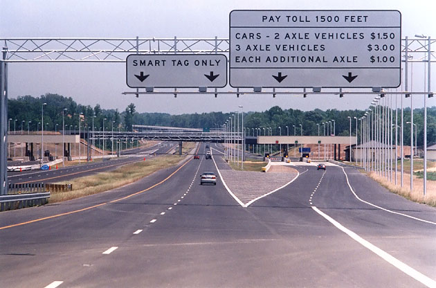
Above, driving on the Route 895 eastbound roadway, a few days after it opened
on May 22. The toll plazas are visible directly ahead. The highway mainline has
three lanes in each direction on this section, and the outer lane each way branches
from the mainline into the manual and automatic cash toll plazas. The center and
inner lanes each way continue as full freeway-standard mainline roadways, and
an overhead gantry has the electronic equipment for electronic toll collection,
and these two lanes each way are to be used only by
Smart Tag
customers. So the Smart Tag customers have a bona fide freeway roadway where they
can maintain the full posted speed limit on the highway. Today
E-ZPass customers can
also use the high-speed lanes, and the sign has been modified to reflect that.
"VDOT
to Open Portion of Route 895 in May", VDOT news release, April 4,
2002. Excerpts follow (blue text):
Memorial Day weekend signifies for many the unofficial beginning of summer
vacation season. This year, the holiday will also inaugurate a new transportation
era for Richmond motorists with the partial opening of Route 895, The Pocahontas
Parkway, connecting Interstate 95 and Chippenham Parkway in Chesterfield County
with I-295 near Richmond International Airport in Henrico County. The Virginia
Department of Transportation (VDOT) and FD/MK, the contractors working since 1998
to complete the $324 million project, will open all eastbound lanes from Chippenham
Parkway at I-95 to I-295 in Eastern Henrico County the week of May 19. This includes
the high-level bridge carrying the parkway over I-95 and the James River, offering
a new river crossing connecting Chesterfield and Henrico counties. Additionally,
motorists will be able to use the westbound lanes of the facility from I-295 to
the Laburnum Avenue interchange, near Route 5 in Henrico County. "We could have
waited for every facet of construction to be completed this fall before allowing
traffic to use the roadway," said Ray D. Pethtel, VDOT's interim commissioner.
"However, we realize that we can provide a valuable service to Virginia's motorists
by opening portions of this facility as they are finished. Opening the completed
portions of the Pocahontas Parkway will begin saving time and money for motorists
and for businesses who will use the new highway to deliver goods and services
to the Richmond region and to other areas of the Commonwealth."
"Portion
of Pocahontas Parkway to open in mid-May",
Richmond Times-Dispatch,
April 5, 2002. Excerpts follow (blue text):
Half a road is better than none, the Virginia Department of Transportation
believes. During the week of May 19, the state highway department will open the
eastbound lanes of the $324 million Pocahontas Parkway. With its partial opening
just before the Memorial Day weekend, the new toll road will cross the James River
to connect Interstate 95 and Chippenham Parkway in Chesterfield County with Interstate
295 near Richmond International Airport in Henrico County. Motorists will also
be able to use Pocahontas' westbound lanes from I-295 to the Laburnum Avenue interchange,
near state Route 5 in Henrico. Originally set for completion next Tuesday, the
8.8-mile Pocahontas Parkway should finally be opened to traffic in both directions
in the fall, the spokesman said.
VDOT announced another plan, to provide a toll-free test drive period, and
10% discounts for Smart Tag users.
"
Free
60-Day Pocahontas Parkway Test Drive and Discounts for Smart Tag Riders", VDOT
news release, April 23, 2002. Excerpts follow (blue text):
The Virginia Department of Transportation (VDOT) will mark the May 22 opening
of Route 895, the Pocahontas Parkway, with a free test drive period and discount
program for Smart Tag riders. For the first two weeks, everyone can ride the road
for free before VDOT will begin charging the $1.50 toll. Those who have a Smart
Tag will enjoy 60 days of free ridership. After the 60-day free period, Smart
Tag riders will receive an ongoing 10 percent discount. "The 60-day free period
and the 10 percent discount aren't the only benefits for Smart Tag riders," says
Joseph R. Jenkins, president of the Pocahontas Parkway Association. "Our new Smart
Tag lanes are the first in Virginia to let you travel through at highway speeds.
Drivers won't have to slow down at all for the system to read their current Smart
Tag transponder. It's brand-new technology, making highway-speed toll collection
possible in Virginia for the first time."
The above news release also set the May 22 opening date.
"Who says there's no free ride? Enjoy parkway toll-free
for its first two weeks",
Richmond Times-Dispatch,
April 26, 2002. Excerpts follow
(blue text):
Each day, hundreds of interstate drivers marvel as they pass below the soaring
spires that carry the Pocahontas Parkway across the skyline east of Richmond.
But nobody is more in awe of the roadway's breathtaking heights than Herb Morgan.
"It's super cool," said Morgan, a project director with Fluor Daniel and Morrison
Knudsen. Despite nearly four years overseeing the ups and downs of construction
on the project, Morgan still sounds like an excited kid when he talks about the
roller-coaster roadway that will soon launch drivers 150 feet over the James River
and complete the link between western Chesterfield and eastern Henrico. Beginning
this time next month, Morgan and others close to the project are betting that
area drivers will be equally amazed.
I met Herb Morgan at the three
American
Society of Highway Engineers (ASHE) field trips that I went on to Route
895's construction (June 2000, Oct. 2001, May 2002). He was one of the tour
guides.
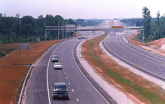
Above, standing on the Osborne Turnpike overpass bridge, looking west onto
Route 895, a few days after it opened. The eastbound roadway was opened to traffic
on May 22, 2002, and it is already carrying significant volumes of traffic. The
overpass bridge in the distance is Wilton Road, and the toll plaza can be seen
just beyond that, and in the distance can be seen the roadway leading up to the
Route 895 James River Bridge which can be seen also.
"VDOT Announces Pocahontas Parkway
Completion Date - All Lanes to be Open to Traffic Sept. 20", VDOT news
release, August 12, 2002. Excerpt follows (blue
text):
Crews building the 150-foot
high Route 895 bridge over the James River and Interstate 95 can see a lot of
things from their lofty perch, but a new focal point has recently emerged on the
horizon - the finish line. The Virginia Department of Transportation (VDOT) and
FD/MK, the contractor building the Pocahontas Parkway, announced today that the
four-year project to complete the $324 million highway will end Sept. 20. The
highway's eastbound lanes between I-95 and Chippenham Parkway in Chesterfield
County and I-295 near Richmond International Airport in Henrico County, as well
as westbound lanes from I-295 to Laburnum Avenue, have been open to traffic since
May 22 while crews completed the westbound bridge carrying Route 895 over the
James River.
VDOT opened the final phase of Route 895 on Friday, September 20, 2002. This
included the westbound main span of the James River Bridge, Ramp H which connects
westbound Route 895 to northbound I-95, and Ramp G which connects westbound Route
895 to southbound I-95. The rest of Route 895 opened on May 22, 2002. Everything
was open to traffic except for one ramp, the ramp from I-295 northbound to Route
895 westbound, and it was completed in October 2002. From what I heard at the
opening ceremonies, the PPTA work is nearly complete for getting the Airport Connector
Road funded (it was not part of the 1998 PPTA agreement for the rest of Route
895).
I attended the opening ceremonies. It was excellent, and before the event I
walked from where I parked my car at the toll plaza, all the way up and across
the westbound bridge and out onto the two elevated bridge ramps that connect to
it, and I shot a roll of photos of that and the ceremony itself. The highway opened
at 4:30 PM and I got to drive across that too. Excellent! Route 895 is now complete
in both directions along its full length between I-95/VA-150 and I-295.
27 photos taken on opening day - Route
895 Opening - September 2002
"Pocahontas
Parkway Opens All Lanes - James River Span Dedicated as Vietnam Veterans Memorial
Bridge", VDOT news release, September 20, 2002. Excerpts follow (blue text):
The Virginia Department
of Transportation (VDOT) and FD/MK, the contractor building the Pocahontas Parkway,
along with political luminaries and Vietnam veterans, dedicated the Parkway's
signature bridge today just prior to the opening of all lanes. The celebration
marked the four-year $324 million public-private transportation project's completion.
Officials presiding at the dedication and ribbon
cutting included: Senators John Warner and George Allen, Congressman Randy Forbes,
former Lt. Governor John Hager, Secretary of Transportation Whitt Clement, VDOT
Commissioner Philip Shucet, Tom Hawthorne, VDOT Richmond District Administrator,
Virginia Representatives Jackie Stump and Kirkland Cox, Colonel Wesley L. Fox,
USMC (Ret.) Medal of Honor Recipient, Lt. Colonel Howard V. Lee, USMC (Ret.) Medal
of Honor Recipient, Bruce MacDougall, USN Seabees, Vietnam Veteran, and Master
Sergent William A. Davis USA (Ret.).
The parkway is the first project completed under Virginia's Public Private Transportation
Act of 1995. The legislation allows private companies to build public facilities
using alternative funding sources. Only $27 million of the $324 million Pocahontas
Parkway project was funded using public money. Bonds were issued to fund the remainder
of the project and the $1.50 toll will be used to recoup the bondholders' investment.
See VDOT
Photos of the Dedication.
"For
Service and Sacrifice: Parkway honors Vietnam veterans",
Richmond Times-Dispatch,
September 21, 2002. Excerpts
follow (blue text):
The Route 895 bridge's
sweeping arches rise over Interstate 95 to carry the Pocahontas Parkway 150 or
so feet above the slow, rolling waters of the James River. And now those soaring
arches carry more than traffic. The Vietnam Veterans Memorial Bridge, as it was
dedicated yesterday, will stand in remembrance of the 1,305 Virginians who died
during that conflict and to the more than 50 who remain missing in action. "It
is my hope that this mighty structure will serve as a daily reminder of the mighty
sacrifice of our Vietnam veterans," said Rep. J. Randy Forbes, R-4th. Sen. John
W. Warner, R-Va., who served as Secretary of the Navy during much of the Vietnam
War, was another who came to remember the veterans' efforts on what was also National
POW/MIA Recognition Day. Warner lamented the more than 2,000 Vietnam veterans
who remain unaccounted for nationally.
And for those who return, "When
they came home, they didn't come home to the open arms and gratitude of America,"
Warner told a crowd peppered with the recognizable service pin and memento-covered
olive drab and blue overseas caps worn by members of veterans organizations.
Builders initially estimated that the Pocahontas
Parkway would cost $324 million, but the project came in $10 million under budget.
The dedication ceremony was punctuated by military pomp, the
mournful strains of taps on a
bugle and a low flyover by two Vietnam-era helicopters
based at nearby Fort Lee. The UH-1 "Huey" helicopters were the workhorses of ground
forces in Vietnam, used for moving troops and supplies to and from combat zones.
Dedicating the roadway to Vietnam veterans was the right thing to do, said Sen.
George Allen, R-Va., who as governor worked for the passage of the transportation
act that made the bridge's construction possible. "When you came back, it wasn't
the homecoming you deserved," Allen said. "You are our heroes. It's commemorated
on this bridge."
Route 895 Pavement Design
The Route 895 roadways have asphalt pavement
throughout. All paved shoulders on the entirety of
Route 895 are comprised of asphalt. All bridge decks are comprised of
reinforced concrete.
Asphalt concrete or bituminous concrete is the correct technical name for this
material, which is a mix of liquid asphalt, crushed stone, and sand. Asphalt itself
is a very heavy distillate of crude oil, and is almost solid at room temperature.
To create the pavement mix, an plant with a mixing barrel device and stocks of the
necessary materials, injects the designed proportions of crushed stone and sand into
the mixing barrel, and while the barrel rotates, the material is heated with a huge
blowtorch-like flame, and liquid asphalt heated to about 200 degrees Fahrenheit to
make it liquid, is injected into the mixing barrel to be mixed along with the crushed
stone and sand. The proportions and temperature vary depending on the mix design, but
a typical mix design would include 4% liquid asphalt by weight and the mix would be
heated to 300 degrees Fahrenheit to provide a plasticized batch of asphalt concrete
that is deposited into a dump truck's cargo body, and then the dump truck has about
45 minutes maximum (because the material immediately begins to cool and harden) to transport
the load to the highway project site where it is deposited
into the roadway paving machines for placement as a layer of asphalt concrete on
the roadway under construction. Heavy roller vehicles compact the placed pavement layer.
When the hot asphalt concrete cools down to 100
degrees or less, it becomes the hard, solid pavement that we see on the highway.
Asphalt pavement layers have three common types, a base layer with course aggregate
(size one inch and larger stones), that makes up 1/2 to 2/3 of the thickness of the
asphalt pavement; an intermediate layer with somewhat smaller aggregate, that is placed
on top of the base layer; and a surface layer with fine aggregate (about 3/8 inch size
and smaller stones), that is placed on top
of the intermediate layer, and is the surface that road vehicles ride on. Usually there
is a subbase layer of crushed stone placed on the earth, and the asphalt pavement base
layer is placed on top of the subbase.
The following typical section of the
Route 895 asphalt pavement on the mainline roadway lanes, comes from the VDOT
final design plans for the state project 0895-043-F01,C502, which is the Route
895 segment from VA-150 Chippenham Parkway to VA-5 New Market Road.
Pavement structure from top down
90 kg/m2 - Asphalt Concrete Type SM-2D
120 kg/m2 - Asphalt Concrete Type IM-1D
200 mm - Asphalt Concrete Base Material Type BM-3
75 mm - Stabilized Open Graded Aggregate
200 mm - Hydraulic Cement Stabilized Aggregate Base Material Type 1, No. 21-A
(4% Cement By Weight)
Notes: kg - kilograms, m2 - square meters, mm - millimeters.
The open graded drainage layer Stabilized Open Graded Aggregate is
comprised much like a somewhat course layer of asphalt concrete. Aggregate Base
Material is not asphalt concrete, it is a mixture of crushed stone about 1/2 inch and
less in size, and much finer crushed stone that is the size of sand. Each of these layers
are heavily compacted by roller vehicles after placement of the layer. The SM-2D
is the asphalt surface course, the IM-1D is the asphalt intermediate course,
and the BM-3 is the asphalt base course.
90 kg/m2 of SM-2D works out to about 1.5 inch depth
120 kg/m2 of IM-1D works out to about 2.0 inch depth
200 mm = 9.87 inches
75 mm = 2.95 inches
The above pavement design works out to a 16.3-inch depth of asphalt concrete
on top of 8 inches of cement-stabilized (strengthened) crushed stone subbase material. This for the Route
895 mainline roadways; the design for the paved shoulders would be somewhat thinner.
Route 895 Road Trips
My first road trips were taken in the week after the May 22nd opening, so the
text below reflects what was open at that point.
The Route 895 Pocahontas Parkway opened to traffic on Wednesday May 22, 2002.
The entire 8.8-mile-long eastbound Route 895 roadway opened, from VA-150/I-95
to I-295; and part of the westbound Route 895 roadway is open, that from I-295
to Laburnum Avenue. The Route 895 westbound roadway from Laburnum Avenue to VA-150/I-95
did not open then, since construction was still underway on the westbound James
River Bridge (JRB), and on Ramp H (westbound Route 895 to northbound I-95), and
on Ramp G (westbound Route 895 to southbound I-95). Ramp E (northbound I-95 to
eastbound Route 895) is open. I took a number of Route 895 road trips during the
first week that it was open.
The 0.5-mile-long 4-lane Laburnum Avenue Extension to Route 895 is open, and three
of its four ramps with Route 895 are open; the ramp to westbound Route 895 is
not open. The westerly ramps are 2-lane 45-mph roadways, and the easterly ramps
are single lane with about a 30 mph design.
The Route 895 interchange with I-295 is Exit 25 of I-295, and three of the four
ramps are open. The loop ramp from northbound I-295 to westbound Route 895 is
still under construction and is not open. The northerly ramps are single lane
and are comfortable at 50 mph.
The Route 895 mainline is a nice ride, with 6 lanes in the James River Bridge
area and 4 lanes elsewhere. The median is 64 feet wide. All of Route 895 is built
to full freeway standards. The mainline speed limit is 55 mph.
I drove Ramp E also, and it is an easy drive (northbound I-95 to eastbound Route
895). It involves an about 150 foot rise in elevation from I-95 to the main span
of the Route 895 James River Bridge, but the exit from I-95 is gradual, and you can move
up the ramp at 60 mph on a gradual vertical curve, then it is a long straight
upgrade, then a 45 mph curve as it ties into the river bridge. The ramp has one lane with
shoulders on each side. Like I say, the whole ramp is very long (about 3/4 mile)
and very gradual. The sustained grade on Ramp E is 5.594%, per the VDOT design
plans.
Route 895 Pocahontas Parkway is a freeway extension of VA-150 Chippenham Parkway,
and as I drove the eastbound Chippenham/Pocahontas roadway, it was a 55 mph freeway
design from there, across the JRB, and into Henrico County. The mainline toll
plaza is about 1/2 mile east of the JRB, and as I've said before, for Smart Tag
users it is a standard 4-lane (2 each way) freeway, and for cash tolls there are
ramps into conventional cash toll plazas with 3 toll booths in each of the two
toll plazas (one each way). Portable signs are in place which notify drivers of
the free test drive period, but they instruct non-Smart Tag drivers to pass through
the toll plaza; so it sounds like the Smart Tag equipment is reading transponders
albeit not charging a toll. I have a Smart Tag and I drove both the mainline roadway
and through the toll plaza later.
The James River Bridge is nice, with three lanes and full emergency shoulders.
The westbound bridge is still loaded with construction equipment including the
form travelers which are being used to construct the cast-in-place bridge segments.
The view from the bridge is nice, and downtown Richmond can be seen 7 miles away.
The bridge has continuous illumination at night.
The entire land portion of Route 895 has an enclosed stormwater management system.
All storm water drainage is captured in a series of stormwater management basins,
and you can see them adjacent to the highway as you drive it. We were told by
the FD/MK LLC project manager at a recent field trip to the project, that the
system can hold up to 6 inches of rain in a 24-hour period. This type of system
is a recent new development in highway environmental design, and from what I understand
it will be standard on future projects. The basins are large; they look like up
to an acre each, so they do require extra right-of-way. Various combinations of
ditches, drop inlets and underground pipes are used to channel the storm water
from the roadways to the stormwater management basins. The basins have treatments
that are designed to absorb the various roadway runoff effluents such as oil,
grease, rubber particles, and metal particles. Periodic maintenance will extract
the absorption layer and take it to a sludge treatment plant, and will replenish
the absorption layer. So there is a significant extra cost to provide this system,
but it is something that I am strongly in favor of.
The westbound Route 895 control city is Richmond, and there is no eastbound control
city, just "I-295". There is light but steady traffic on the eastbound highway,
and very light traffic on the partially complete westbound highway. In their news
releases, VDOT and the Pocahontas Parkway Association have said they hope that
the free test drive period will "hook" motorists so that they will be more than
willing to pay a toll to use the road ($1.35 for cars with Smart Tag, $1.50 for
other cars).
There was an opening ceremony on the morning of
Wednesday, that the contractor put it on. The usual dignitaries where there,
state officials and contractor personnel. The local TV stations had clips of the opening
ceremony on the news that night. It was held at the highest point of the main
span of the James River Bridge, over the river. I also saw the series of photos
that my photographer buddy took at the ceremony.
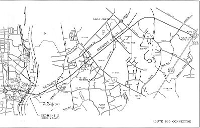
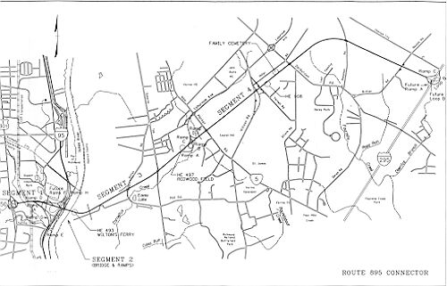
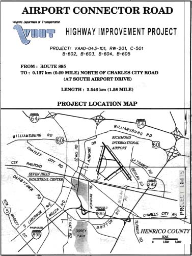
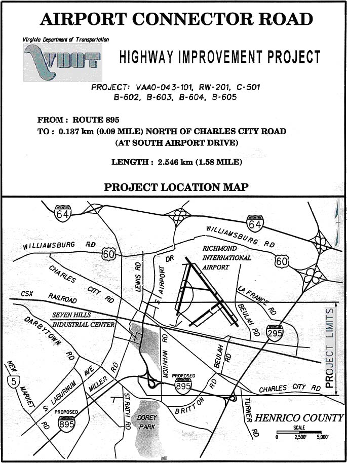
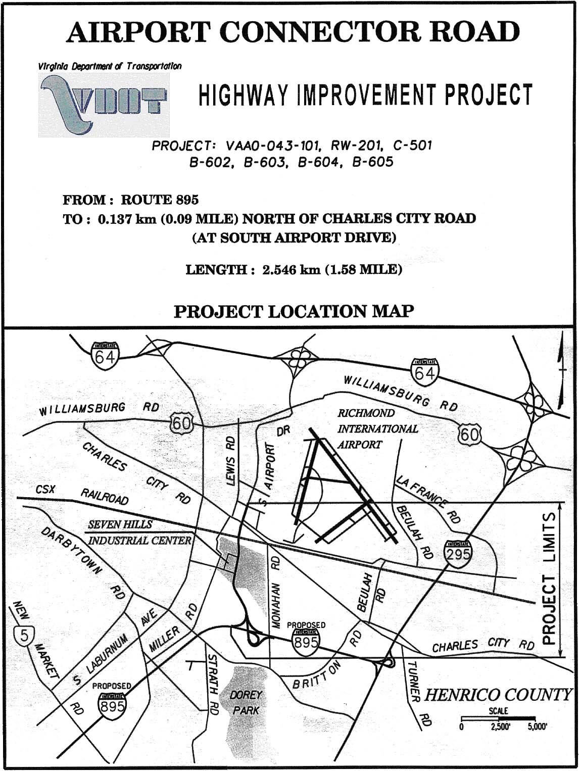
Route 895 Airport Connector Road
Planning studies are underway for a connector from Route 895 to the
Richmond International Airport.
Route 895 passes less than a mile from the southern end of the airport access
road, and this connector will facilitate access to the airport from the south,
providing direct southerly access to/from I-95 and I-295. The connector will also
provide additional local access to residences and businesses in area. This includes
building the southerly ramps at the Route 895/I-295 interchange, so that I-295
traffic will have a full freeway connection to the airport via Route 895. The
southerly ramps at I-295 were begun in the Fall of 2001. VDOT conducted a Location
and Design Public Hearing for the 1.6-mile-long, 4-lane divided Airport Connector
Road on December 12, 2001, and I attended the meeting. VDOT engineers there told
me that they anticipated that the Commonwealth Transportation Board (CTB) would
approve the location and design of this connector road in the Spring of 2002,
and that the Pocahontas Parkway Association will sell $36 million in additional
bonds to complete this project as an extension of FD/MK LLC's design-build contract
for the rest of Route 895, and that construction would begin in the Fall of 2002
(it has not yet begun as of November 2006, and it will be funded by Transurban
LLC, who assumed the role as the new private partner in June 2006). The Airport Connector Road will have
a trumpet interchange with Route 895 just west of where Monahan Road crosses Route
895, with ramp tolls on the interchange ramps that will serve traffic to and from
I-295 to the east (traffic to and from I-95 to the west will have tolls collected
on the Route 895 mainline toll plaza); and the Airport Connector Road will have
an at-grade intersection with Charles City Road and South Airport Drive. Projected
traffic volumes on the Airport Connector Road are 9,100 vehicles per day in 2005.
Completion of this important addition to Route 895 will bring significantly more
traffic onto Route 895, thus enhancing toll revenues and the financial health
of the highway.
The CTB approved the location, design and construction of this connector road,
on February 21, 2002, "
Latest
Action from the Commonwealth Transportation Board",
VDOT News Release, 2-21-2002. Excerpt (blue text):
The CTB also approved ... the construction
of Route 895 (Airport Connector Road) in Henrico County.
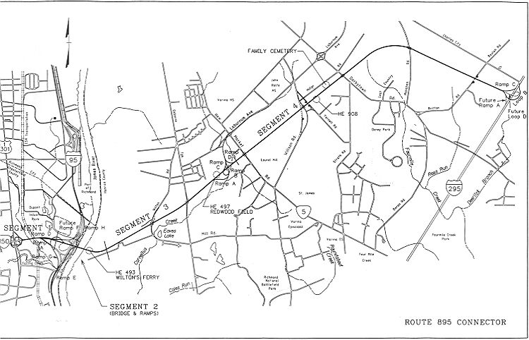
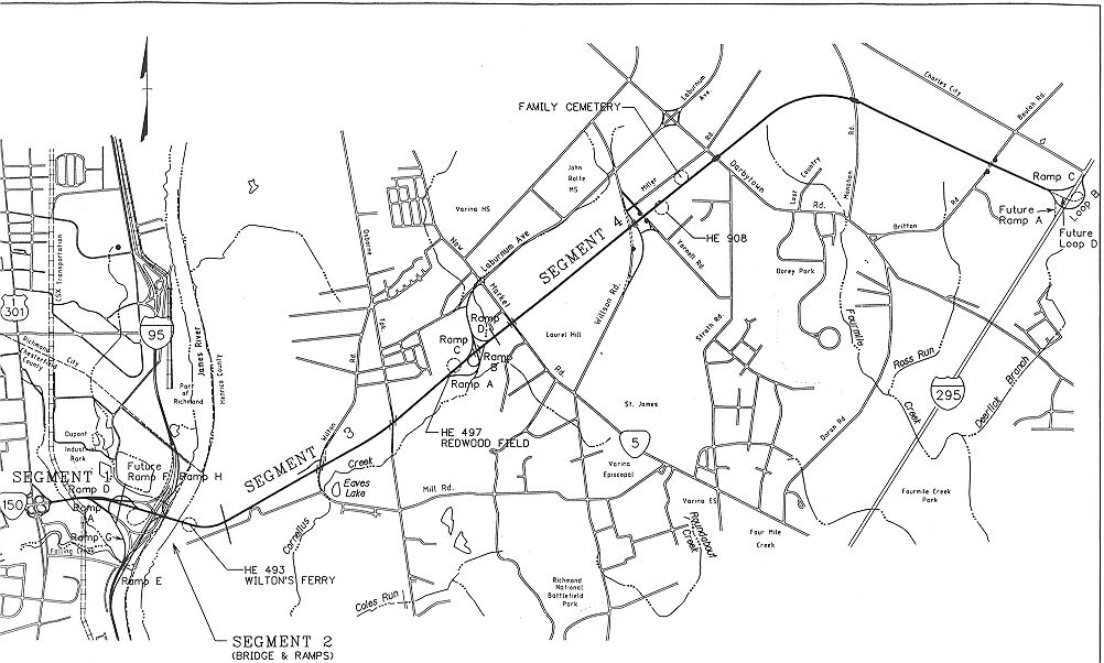
Future Ramp F at I-95/Route 895/VA-150 Interchange
Ramp F is a proposed ramp that was not
built in the initial Route 895 construction. This is the ramp from I-95 southbound
to Route 895 eastbound. The aerial engineering artist's
rendering of the I-95/VA-150/Route 895 interchange, posted on this website
article, was developed
by VDOT well before the construction started. The project
map from FD/MK LLC shows what they built. The resolution suffered some
when Roads to the Future scanned the map, but a close look will show that "Future Ramp F" is shown
by a dashed line, and that is the elevated loop ramp being referred to.
When the PPTA agreement was being worked out in 1998, revised toll feasibility
studies revealed that the proposed toll structure ($1.50 for cars, $3.00 for 3-axle
vehicles and $1.00 for each additional axle) wouldn't support the entire plan.
That is why that ramp's construction got postponed, since it was estimated to
cost $16 million, and it would carry a low volume of about 1,800 vehicles per
day, a strictly local movement from the I-95/Bells Road area to Route 895 eastbound.
It would be good to see it built, since it would complete the interchange functionally
as well as in the photos. I asked a Route 895 project manager about the ramp in
April 2002, and he told me that there are no current plans to build the ramp.
I've been up on the Route 895 James River Bridge, and the ramp stub and acceleration
lane has been built as part of the bridge. He and I talked about what will undoubtedly
become the unofficial freeway connection for that movement. A vehicle can enter
I-95 southbound at Bells Road, exit onto VA-150 westbound, take VA-150 for 0.5
mile to the US-1 interchange, go through two consecutive loop ramps, putting it
onto VA-150 eastbound leading to Route 895 eastbound.
It is a shorter distance from the I-95/Bells Road interchange, to Route 895,
that way, than by using Bells Road and US-1/US-301 Jefferson Davis Highway. When
the widening of VA-150 is completed in mid-2002, it will be 3 lanes each way,
and the limited amount of local traffic making this movement should have free-flowing
roads to travel on even in peak hours. And it will be a freeway-to-freeway connection.
Cars and trucks from the commercial area around the Port of Richmond and Philip Morris Co., will be able to use this movement. The local businesses
should inform their employees and customers about how to make this movement, perhaps
even draw up a little map showing it. Given the low traffic volume and the unconventional
movement, I doubt that VDOT will officially announce it; but it will certainly
be handy for anyone who uses it. And it will complete the I-95/Route 895 interchange
movements.
Route Number Designation for Route 895
On 10-22-99, I communicated with a VDOT public affairs person about the Route
895 Connector's route numbering. This is what I found out (blue text):
Route 895 is technically
classified as a route. We anticipate that, when complete, it will carry an
Interstate shield. However, the Commonwealth Transportation Board will need to
approve that designation closer to the time when the road opens.
On 8-31-01, I communicated with a VDOT public affairs person in the same regional
office, and this is what I found out (blue text):
The 895 signs will carry a state route
shield, just like Route 288. This is what the CTB has approved for that. If you
were concerned about that designation, you can send a letter to the CTB
offices. The road is being built to Interstate standards, but for the
foreseeable future, it will be a 'Route'.
So the CTB decided to designate it as a state primary route, and not as an
Interstate. That is interesting, since it was called Interstate 895 first in the
early 1980s, and afterward in the VDOT Six Year Program, and it was Interstate 895 at
the Design Public Hearing in 1997 and on the Design Public Hearing document (I
have a copy). Normally Virginia route numbers 600 and above are only for the secondary
system (599 and below are for primary or Interstate), and special exceptions
were made for two route numbers, 664 and 895, to be Interstates.
The VDOT state map for 2000-2001 shows Route 895 with an Interstate shield. Strangely,
they even call it "I-895" on the project location map in the Location and Design
Public Hearing brochure for the Airport Connector Road; for the meeting held on
December 12, 2001 (see map above).
Three-digit Interstate routes have a leading digit with the last two digits
being the mainline route that it supplements, so I-x95 routes would have routes
such as the ones in Virginia, I-195, I-295, I-395 and I-495. I-664 is an I-x64
route. An odd-number leading digit signifies a spur route off a mainline route
(examples are I-195 and I-564). An even-number leading digit signifies a loop
around a city (examples are I-295 and I-495), or a branch route through a city
(an example is I-264). Three-digit Interstate route numbers can duplicate, but
not in the same state. AASHTO (the American Association of State Highway and Transportation
Officials) is the national organization that has control over assigning Interstate route
numbers. When VDOT obtained the I-664 number in 1972, they changed the VA-664
secondary routes in Suffolk and Chesapeake to another route number to avoid motorist
confusion. No even-number leading digit I-x64 routes were available that were
less than Route 600, since I-264 and I-464 had already been used in Virginia.
When VDOT decided in 1983 to assign an Interstate number to the "I-95/I-85 Connector",
they followed the AASHTO numbering rules and used an even-number leading digit
I-x95 route, and decided to avoid I-695, even though it was available in Virginia
(I-295 and I-495 were the only ones that had been used so far) because the two
counties involved (Henrico and Chesterfield) already had VA-695 secondary routes
but no VA-895 secondary routes, so VDOT and CTB decided to avoid the motorist
confusion of another set of secondary route number changes, and they assigned
Interstate 895 to the "I-95/I-85 Connector", since it would connect I-95 to I-295.
So this explains how this highway, which is being signed as VA-895 as I write
this in February 2002, has a number that would normally be in the Virginia secondary
system, and not in the Virginia primary system as it is being signed with the
Virginia primary route shield.
The upshot of this discussion is that the route number "895" came into existence
when the intent was for the highway to be an Interstate, and the fact that it
was changed to a primary, hasn't led the CTB to change it to a number of 599 or
lower as is the normal rule for Virginia primary roads. If they wanted to follow
Virginia's route numbering rules to a "T", they could simply designate it as an
extension of VA-150 if they want to use a primary numbered route instead of an
Interstate numbered route. Having both I-895 and VA-150 on what is essentially
one seamless freeway, made sense when the portion east of I-95 was going to be
signed as an Interstate highway (VA-150 Chippenham Parkway is a good freeway but
it is not built to full Interstate standards); but if Route 895 is going to be
designated as a primary, they (in my opinion) ought to just use one primary route
number on the whole thing (Chippenham and Pocahontas), and VA-150 would seem to
be the obvious choice.
I have a copy of a 1984 VDOT letter with the Section 139(b) Agreements between
VDOT and the Federal Highway Administration (FHWA), for the addition of I-664 south of Hampton Roads, and I-895, to
the Interstate system. A federal Section 139(b) Agreement (at least as performed
back then) provided for the designation of new Interstate mileage, but with the
specification, "The designation of a highway as part of the Interstate System
under this section shall create no Federal financial responsibility with respect
to such highway". (Quote is from attached copy from the U.S. Code). In other words,
if the highway is built to Interstate standards, and the state DOT and FHWA consider
it to be a logical addition to the Interstate system, then this agreement could
be used to designate the highway as an Interstate highway, but without FHWA having
the responsibility to fund 90% of the highway's construction (and right-of-way
acquisition), contrary to the rule for the original Interstate system mileage
which was built with 90% FHWA funding. However, this didn't prevent the state
from the possibility of using some other form of FHWA federal aid allocations
to build the highway, as was the case with I-664 south of Hampton Roads, which
was built with 90% FHWA Interstate 4R reconstruction funds.
The CTB decided to designate Route 895 as Virginia Route 895. Perhaps they
don't want an Interstate designation on a toll road, but the Richmond-Petersburg
Turnpike had tolls from 1958 to 1992 and carried I-95 and I-85. A number of other
states have toll roads that have Interstate designations.
The big difference between now and 1984 with Route 895, is the fact that in
1998, the public-private agreement was reached to build it as a VDOT-owned toll
road, over 90% privately financed. The fact that it will be a toll road, (I would
surmise) probably means that the CTB would need to revisit the Interstate route
designation issue with FHWA, and get a new agreement. So perhaps the CTB will
need to do that first before using I-895 signs, although they have had over four
years to do that since the construction started in October 1998.
As far as precedents for using Interstate designations on toll roads, I'll
grant that there are very few such examples built -after- the Interstate system
construction began in 1956. Here are the ones that I can think of ---
- I-95 and I-85 Richmond-Petersburg Turnpike - construction began in 1955 and
the highway was opened in 1958
- I-95 Maryland Toll Road (JFK Highway) - opened 1963
- I-95 Delaware Turnpike (JFK Highway) - opened 1963
- I-695 Baltimore Beltway, 9 miles, Key Bridge and approaches - opened 1977 as
MD-695 and designated an Interstate sometime in the 1980s.
- I-355 North-South Tollway near Chicago - opened about 1989
The vast majority of the toll roads in the U.S. built -after- the Interstate
system construction began in 1956, are designated with a state route number or
have no route number at all.
I think that there is a good reason for designating Route 895 in Virginia as
an Interstate highway. Route 895 has six different major traffic service functions.
Four of these are local and interregional functions, and in my opinion the state
primary route number is appropriate for them. However, there are two traffic functions
that are purely interstate.
I-295 provides an outer Richmond bypass for east-west I-64 traffic, and I-295
provides an outer Richmond-Petersburg bypass for north-south I-95 traffic, and
I-295 also provides an outer Richmond bypass for traffic between I-95 north of
the city and I-64 east of the city. Until Route 895 opened in September 2002,
a major missing link in the Richmond regional Interstate beltway was the connection
between I-95 north of Richmond and I-85 south of Petersburg; the through traffic
needed to follow I-95 and I-85, passing through downtown Richmond, if it wanted
to stay on Interstate highways. Now that Route 895 is open, the I-95/I-85 through
traffic has a freeway bypass around Richmond, using Route 895 and I-295 (given
that a section of I-95 will be used between I-85 and Route 895). There is another
Interstate function of Route 895 that was not served before Route 895 existed,
the Richmond freeway bypass for traffic traveling between the I-85 corridor and
the section of I-64 from east of Richmond to Williamsburg.
Every aspect of the design of Route 895 is built to full Interstate standards.
The previously cited interstate traffic functions (in my opinion) justifies the
prominence of an Interstate designation for this highway, so that the motorists
traveling between I-85 south and I-95 north can clearly see that this highway
will provide an Interstate-caliber bypass of the City of Richmond. They know in
advance by signs that it requires a toll. The bypass of I-95 along Route 895 and
I-295 requires 27 miles of travel compared to 17 miles of travel along the section
of I-95 bypassed. At peak hours, the toll and extra distance may be preferable
for a lot of such users, to avoid congestion on I-95 through downtown Richmond.
Perhaps the CTB will eventually decide to designate Route 895 as Interstate
895, maybe after it is open to traffic and serving the public. We'll have to wait
and see. I've made my opinion clear about the issue. I think that it should be
an Interstate. Throughout the Roads to the Future website, whenever I refer to the highway, I call
it "Route 895", rather than with the system identifier that I normally use, with
"VA-xxx" or "I-xxx"; so that I won't have to make a massive amount of changes
if the CTB changes the system to Interstate.
2005 Updated Information About Route 895
Designation
This concerns the reason why the Route 895 Pocahontas Parkway near
Richmond, Virginia, has not been designated as Interstate 895, even though the
I-895 designation was originally approved by the Federal Highway
Administration (FHWA) for the highway back in
1984.
The upshot of the issue is that as the tollroad Pocahontas Parkway was nearing
completion (full completion of the highway occurred on September 20, 2002, and
built to full Interstate standards); in December 2001, VDOT submitted a
request to the FHWA Virginia Division for the Interstate I-895 designation for
the tollroad; in January 2002, the FHWA Virginia Division forwarded the
request to FHWA Headquarters (in Washington, D.C.) with a recommendation that
the request be approved; and in March 2002, FHWA Headquarters ruled that the
request could not be approved per Title 23, United States Code.
A technicality in current federal law is the obstacle...
In 1983, the Commonwealth Transportation Board (CTB) gave location approval
for the I-95/I-85 Connector from the interchange of I-95 and VA-150, to I-295
and Charles City Road. The Federal Highway Administration (FHWA) gave
tentative approval to use Interstate 4R funds to build this new Interstate
highway as a toll-free freeway. Back then, Interstate 4R was the FHWA program
for Interstate Reconstruction, Restoration, Rehabilitation and Resurfacing.
This approved route was very similar to today's Route 895.
In mid-2004 I contacted Mr. James Atwell, President of the Pocahontas Parkway
Association, and I asked him (blue text),
Are there plans to designate the Route 895
Pocahontas Parkway as Interstate 895? Given the lower-than-expected traffic
volumes, the added visibility of an Interstate designation may help to
increase the traffic. Since the project was financed with private toll revenue
bonds, any help to increase traffic would seem to be a good idea.
Mr. Atwell forwarded me a copy of the FHWA letter that documents the final
decision on the Interstate route number designation issue.
I have copied the letter in full below, where the FHWA Virginia Division
wrote a letter to VDOT, notifying VDOT of the decision. The word "Department"
in the letter refers to VDOT. Scan of
letter. Letter (in blue text):
U. S. Department of Transportation
Federal Highway Administration
Virginia Division
400 N. 8th Street, Rm. 750
P.O. Box 10249
Richmond, VA 23240
April 1, 2002
Subject: Route 895
Mr. C. Frank Gee
Acting Chief Engineer
Virginia Department of Transportation
1401 East Broad Street
Richmond, Virginia 23219-2000
Dear Mr. Gee,
In December 2001, we received the Department's request to designate Route 895
(Pocahontas Parkway) as Interstate 895. In January 2002 we forwarded your
request to our Headquarters with a recommendation that it be approved.
Unfortunately, our Headquarters informed us in March 2002 that your request
could not be approved per Title 23, United States Code. Title 23 Section
129(a)(1)(A) prohibits Federal-aid funding for "construction" of an Interstate
system toll road. Title 23 Section 101 defines "construction" to include
preliminary engineering and right-of-way activities. To date, the Department
has spent $9,279,275 in Federal funds on Route 895 to re-evaluate the
environmental document that was approved in 1984 and to complete approximately
60% of the design. This work is considered preliminary engineering. Although
Title 23 Section 129(a)(1)(E) permits the use of Federal funds to conduct
preliminary studies to determine the feasibility of a toll road for which
Federal participation is authorized, the work performed on Route 895 goes
beyond the feasibility stage permitted under Title 23 Section 129(a)(1)(E).
In view of this decision and per Title 23 Section 103(c)(4)(B)(iv), no
references to the Pocahontas Parkway as future Interstate 895 may appear in
any future laws, rules, regulations, maps or other documents.
If you have any questions, please contact Mr. Roberto Fonseca-Martinez at
775-3320.
Sincerely,
Roberto Fonseca-Martinez
Division Administrator
---end FHWA letter---
I wrote back to Jim Atwell, with all of the following (in blue text):
I understand perfectly what Mr. Fonseca-Martinez wrote, that according to
FHWA's interpretation of federal law, that since Route 895 got some federal
funding for preliminary engineering, and is a tollroad, that it cannot be
designated as an Interstate highway.
VDOT apparently got the $9.28 million from FHWA to re-evaluate the 1984 EIS
and to conduct 60% of the design, before they knew whether Route 895 would be
a PPTA tollroad. It took $314 million to complete the highway, none from
federal funding, and then FHWA says that because the highway got some federal
funding, that it cannot be tolled and also designated as an Interstate!
That is a case of the letter of the law violating the spirit of the law, in my
opinion.
Also, discussions on some on-line road forums indicates that some Interstate
tollroads have gotten a small amount of federal funding, including the
Illinois tollways and the New Jersey Turnpike.
I think that the Interstate I-895 designation would be valuable to the
Pocahontas Parkway, for the reasons that I posted in earlier e-mails.
A few ideas:
1) The FHWA decision looks legally questionable enough that I think that it
should be appealed, perhaps with the help of an attorney that specializes in
federal law, who would investigate every angle of this issue.
2) The new federal transportation bill looks like it may finally be approved
by Congress. I understand that its drafts have had various proposals to
provide more freedom over the various aspects of mixing tolling and federal
aid. We'll have to wait until the final document is approved, but VDOT and PPA
could check to see if there is a clear provision for getting the Interstate
designation.
3) If #1 and #2 don't provide the Interstate designation, what about "buying
it" from FHWA by paying back to FHWA the $9.28 million, thus zeroing out the
federal aid for Route 895? I wouldn't really think that the private investors
should have to pay it, but perhaps VDOT could provide it from public funding.
I think that the value of getting more traffic and more revenue, may be well
worth spending $9.28 million. Traffic has "flattened off" at about 15,000 AADT
over the last 12 months.
It is a shame that VDOT and PPA tried to get the Interstate I-895 designation
for a highway that from a logical standpoint should be an Interstate, and was
approved by FHWA as Interstate I-895 back in 1984, and were turned down on
technicalities in the year that the highway finally was completed.
Regards,
Scott
---end of SMK letter---
The Route 895 PPTA project took that 60% complete design and performed a
design-build project on the rest of the design and the construction.
Actually the AADT is now up to about 16,700, but my points remain.
This is an issue that could use more input to FHWA from interested citizens...
Route 895 Speed Limit
Mostly 65 mph
Route 895 opened to traffic with a 55 mph speed limit. Following traffic engineering
studies, VDOT decided to increase the speed limit to mainly 65 mph. The 65
mph signs were installed Monday October 7, 2002 along 7 miles of the 8.8-mile long
highway, with 60 mph signs to going up later in mid-2003 on the James River Bridge
and its approaches.
I had a bit of input here ... after I e-mailed the Richmond Times-Dispatch
in response to a reader who asked about the Route 895 speed limit.
The Code of Virginia allowed for the possibility of a higher speed limit on
Route 895, possibly as high as 65 mph.
Excerpt from "§ 46.2-870. Maximum speed limits generally" in 2002 --
Notwithstanding the foregoing
provisions of this section, the maximum speed limit shall be sixty-five miles
per hour where indicated by lawfully placed signs, erected subsequent to a traffic
engineering study, on: (i) interstate highways, (ii) highways constructed pursuant
to the Virginia Highway Corporation Act of 1988 (§ 56-535 et seq.), (iii) Virginia
Route 288, (iv) the limited access portion of Virginia Route 37, (v) highways
constructed pursuant to the Public Private Transportation Act of 1995 (§ 56-556
et seq.), and (vi) high-occupancy vehicle lanes if such lanes are physically separated
from regular travel lanes.
HCA 1988 was the enabling legislation for the Dulles Greenway, and PPTA 1995 was
the enabling legislation for other public-private highways, of which Route 895
is the first to be built.
Since over 90% of the funding for Route 895 is from private investors, with
their investment to be recouped by tolls, I think it is wise for VDOT to increase
the incentives for more people to use it; incentives such as an Interstate designation
and a higher speed limit.
"Now
try flying at 65 mph -
Speed limit raised on new parkway",
Richmond Times-Dispatch,
October 4, 2002,
by journalist Chris Dovi. Excerpts follow (blue text):
The injection
of speed was not an original idea spawned by Virginia Department of Transportation
planners. "I read an article in The Times-Dispatch where people were asking about
why the speed limit there was so low," said Scott M. Kozel, who has entertained
a 33-year fascination with area highway and transportation development. The question
reminded him of legislation passed during the 2001 General Assembly session. "I
found the citation in the Virginia code," he said. The clause that stuck out to
him allows speed limits on highways constructed using the Public Private Transportation
Act of 1995 to be posted higher than the 55 mph placed on most state routes. The
Pocahontas Parkway was the first project completed under the act. "I'm not a lawyer
and I'm not an engineer, either. But the code was written in such a way as to
include [Route] 895," Kozel said. Kozel, who worked for 10 years for VDOT doing
highway design and inspection, now does computer work for the state. He channels
his interest in roads into an informative Web site -
www.roadstothefuture.com
- that documents the history and development of roads in Virginia, Maryland and
other East Coast states. VDOT officials acknowledge Kozel's role in the new speed
limits. "Apparently, the legislation was passed and people knew about it, but
it was not remembered as we got closer to completing the road," said VDOT spokesman
Jeff Caldwell. He said Kozel's reminder got the ball rolling.
The article goes on to cite information about VDOT's actions with regard to
traffic engineering studies and the actual raising of the speed limit. They are
covered thoroughly in the following VDOT news release.
"Pocahontas
Parkway Speed Limits To Increase", VDOT news release, October 3, 2002. Excerpts follow (blue text):
Beginning Oct. 7, The Virginia Department of Transportation
(VDOT) will help motorists save even more time when using Richmond's newest highway,
Route 895, The Pocahontas Parkway. VDOT will increase sections of the parkway's
speed limits to 65 mph Monday morning.
"This is a great opportunity for motorists
to benefit even more when they 'Fly Pocahontas,'" said Joseph R. Jenkins, president
of the Pocahontas Parkway Association. "Motorists can save an average of 24 minutes
from their daily round-trip commute across the river." The additional time savings
come as an added bonus to Smart Tag riders who can already use the parkway's high-speed,
open-lane design to pay their tolls at highway speeds. Smart Tag users also currently
receive a 10-percent discount off of the $1.50 toll.
The only means by which a state primary
road such as Route 895 can be posted at a higher speed limit than 55 mph is through
special legislation. In the 2001 session, the General Assembly passed legislation
allowing interstate highways and specifically designating primary highways such
as Route 288 in Chesterfield County to be posted at speed limits up to 65 mph.
A clause in that legislation also allows "highways constructed pursuant to the
Public Private Transportation Act of 1995" to be posted at higher speed limits
after the completion of a traffic engineering study. This summer, VDOT and the
Attorney General's office examined this legislation to be sure it allowed the
Pocahontas Parkway to be posted at higher speed limits. The Pocahontas Parkway
is the first project completed under the Public Private Transportation Act, but
is not specifically referenced in the speed limit legislation.
.
The speed limit is 65 mph from just east
of the mainline toll plaza to approximately one-half mile west of I-295, where
eastbound traffic is slowed to 55 mph to use the I-295 interchange. Speed
limit increases to 60 mph west of the mainline toll plaza followed later in
mid-2003 after specially designed sign structures were erected on the Route 895
James River Bridge.
The 2004 General Assembly passed into law on July 1, 2004, the provision
that all limited access highways in the state could qualify for a statutory
maximum of 65 mph, so that supercedes the 2002 law above. Even so, the above
actions got the higher speed limit on Route 895 almost 2 years earlier than
the 2004 legislation.
Private Firm Assumes Control of Pocahontas
Parkway
An agreement was reached on May 2, 2006, for
a private firm,
Transurban, LLC, to assume the rights and obligations to manage, operate,
maintain and collect tolls on the Route 895 Pocahontas Parkway, for a period
of 99 years, to bring private sector resources to maintain and improve the
parkway. The agreement was reached by Transurban, the Virginia Department of
Transportation (VDOT), and the Pocahontas Parkway Association. The Association
is a non-profit group created to issue and repay the bonds that financed the
construction of the parkway, which opened in 2002. Financial closure
on this transaction was achieved on June 29, 2006.
The agreement requires Transurban to do the
following:
č Pay off
all existing debt of the Pocahontas Parkway Association, approximately $500
million, with a total funding of $611 million in U.S. dollars
č
Reimburse VDOT’s costs incurred to operate, maintain and repair the Pocahontas
Parkway, including upgrading the existing electronic tolling equipment
č Take
responsibility for the cost and management of all operations and maintenance
of the toll facility, including upgrading the existing electronic tolling
equipment
č Finance
and build the Route 895 Airport Connector Road subject to obtaining federal
government loans
č
Establish limits on toll levels and increases
č Requires
sharing of revenues with the Commonwealth if the facility exceeds expectations
VDOT will continue to own the road and
retain significant oversight and approval rights over Transurban’s ongoing
management of the parkway. The agreement requires that Transurban return the
facility to VDOT in satisfactory condition at the end of the 99-year contract
term. It also allows VDOT to reassume control of the road at any point after
40 years, subject to the terms of the agreement, which would include paying
full market value for the highway.
Transurban is expected to take over
operations of the Pocahontas Parkway by November 2006, following a six-month
transition period.
Transurban is an Australian company that is
a publicly listed on the Australian Stock Exchange with a market value in
excess of $4.5 billion in U.S. dollars. The company is owned by about 5
million Australians who have invested in the company through their pension
plans. About 15% of Transurban’s shares are owned by North American investors.
Transurban focuses on the long-term ownership and management of advanced
electronic toll roads.
"Agreement
Reached For Private Firm to Assume Control of Pocahontas Parkway Toll Facility
in the Richmond Region", VDOT news release, May 2,
2006.
"Financial
Close Reached for Private Firm to Assume Control of Pocahontas Parkway Toll
Facility in the Richmond Region", VDOT news release, June 29,
2006.
Roads to the Future opines:
Overall this Pocahontas Parkway concessionaire by Transurban, LLC is a very
good thing. With the lower-than-forecast traffic volumes, there was a
considerable possibility in the next few years, of the Pocahontas Parkway
Association having insufficient toll revenues to fully cover the debt service
on the toll revenue bonds, which could have led to default on some of the bond
interest payments, and financial losses for the private bondholders, or could
have led to the state subsidizing the amount of the interest payments that
were in default. The concessionaire by Transurban effectively eliminates those
possible situations, since they will pay off all the bond debt of the
Pocahontas Parkway Association, and effectively there is zero possibility of
the state providing any subsidies to the Transurban venture. Since Transurban
is a huge enterprise with many individual projects around the world, and with
access to the equity (i.e. stock) markets to raise large amounts of capital,
they should be able to productively manage the Route 895 Pocahontas Parkway in
accordance to the agreement.
Recently there have been several concessionaire acquisitions of toll highways
in the U.S.A., by foreign private enterprises. In January 2005, the Skyway
Concession Company, LLC (SCC) assumed operations on the
Chicago Skyway
with a 99-year operating lease, with payment to the City of Chicago (the
original Skyway owner) of $1.83 billion U.S. dollars for the concession. SCC
is responsible for all operating and maintenance costs of the Skyway, but has
the right to all toll and concession revenue. This agreement between SCC and
the City of Chicago is the first privatization of an existing toll road
anywhere in the United States of America (U.S.A.). Skyway Concession Company
is owned by Cintra Concesiones
de Infraestructuras de Transporte S.A. and Macquarie Infrastructure Group.
In June 2006, a partnership between Cintra Concesiones de Infraestructuras de
Transporte S.A. and Macquarie Infrastructure Group, assumed a 75-year lease to
operate and maintain the
Indiana East-West Toll Road (ITR), with payment to the state of Indiana
(the original ITR owner) of $3.85 billion U.S. dollars for the concession.
This is the same partnership that operates and maintains the adjoining Chicago
Skyway in Illinois. The Cintra-Macquarie joint-venture assumed operation of
the Indiana Toll Road from the Indiana Department of Transportation (INDOT) on
June 30, 2006. Toll roads operated by Cintra include
407 ETR in Ontario,
Canada, the Chicago Skyway, the Indiana Toll Road, and numerous roads in
Spain, as well as the
Trans-Texas Corridor TTC-35 (currently in development,
to be operated as a partnership with San Antonio, Texas based Zachry
Construction Company). The
Macquarie
Infrastructure Group is one of several listed trusts managed by Macquarie
Bank Limited, which is in Australia. Macquarie Infrastructure Group is one of
the world's largest developers and operators of private toll roads with a
portfolio (as of November 2006) of 11 toll roads across seven countries
including Australia. The Macquarie Infrastructure Group is listed separately
on the Australian Stock Exchange, but is managed by a wholly owned subsidiary
of Macquarie Bank
Limited.
Some folks in the U.S.A. have asked the question similar to, “Is it a bad
thing for our public highway infrastructure to be sold to foreign private
enterprises”? There are two basic fallacies contained in that question. First,
these toll highways are not being “sold”, as the highways continue to belong
to the associated U.S. state or city that originally owned them, and the
concessionaire is a very long-term lease that conveys most of the business
rights toward managing and operating the toll highway, but the associated
U.S.A. state or city still has oversight rights to the toll highway. These are
privatization partnering agreements between the original governmental owner of
the highway and the concessionaire private company. Secondly, business people
in the U.S.A. have every opportunity to establish private companies that are
in the business of managing and operating toll highway concessionaires, and
they could enter that market and attempt to negotiate the purchase of the
concessionaires from these foreign companies, for currently concessioned
highways in the U.S.A., such as the Chicago Skyway, Indiana Toll Road,
Pocahontas Parkway, and any others; and for any toll highways U.S. and
foreign. Business people in the U.S.A. have every opportunity to enter this
global market, if they so desire, so there is really no reason for anyone in
the U.S.A. to complain about these recent concessionaires, on the basis that
they are currently owned by foreign private companies.
Route 895 Photo Articles
These articles were prepared by Roads to the Future during
the construction and tracked the project's progress on a monthly basis.
6 construction photos - Route 895 Construction
5 construction photos - Route 895
Construction - June 2000
4 construction photos - Route 895
Construction - March 2001
4 construction photos - Route 895
Construction - April 2001
10 construction photos - Route 895
Construction - May 2001
4 construction photos - Route 895
Construction - June 2001
8 construction photos - Route 895
Construction - July 2001
16 construction photos - Route 895
Construction - August 2001
6 construction photos - Route 895
Construction - September 2001
28 construction photos -
Route 895 Construction - October 2001
(includes ASHE field trip)
6 construction photos -
Route 895 Construction - November 2001
10 construction photos -
Route 895 Construction - December 2001
4 construction photos -
Route 895 Construction - January 2002
28 construction photos -
Route 895 Construction - February 2002
20 construction
photos -
Route 895 Construction - March 2002
3 construction photos - Route 895
Construction - April 2002
12 construction photos - Route 895
Construction - May 2002
(includes ASHE field trip)
26 construction photos - Route 895
Construction - June 2002
6 construction photos -
Route 895 Construction - September
2002
27 photos on opening day - Route 895
Opening - September 2002
9 photos of completed Ramp E - Route
895 - Ramp E - Completed
External Route 895 Links
Pocahontas Parkway
Connector page on the VDOT website.
Pocahontas Parkway,
by Transurban LLC.
Fluor Daniel Venture Begins Design and Construction
of Virginia's Route 895 Connector, press
release by Fluor Corporation, July 27, 1998.
"InTranS Group Selected for Virginia Route 895 Toll
System",
press release by ETTM, July 13, 2000.
The Route 895 Connector Pocahontas Parkway Project,
by John A. Stuart, PE, Moffatt & Nichol Engineers, and past President,
Old Dominion
Section of the American
Society of Highway Engineers.
Innovative Finance - Projects - Virginia I-895
(Pocahontas Parkway),
by innovativefinance.org, May 2001.
"Route 895 Connector",
by Fluor Corporation.
"Participation in Public-Private Partnerships",
by Flour Corporation, a list of public-private partnerships.
"Fitch Affirms Pocahontas Pkwy Association, VA,
Sr Bonds At 'BBB-'
", press release
by ETTM, December 4, 2000.
"Pocahontas
Parkway, Route 895, is Virginia's first PPTA project", from National Engineering
Week,
Richmond
Times-Dispatch.
Design/Build on Pocahontas Parkway Project, from Allen Armstrong O.R. Colan
& Associates, from
AASHTO website.
Virginia
Highway Project Boasts One of the Country's Biggest Bridges - Pump equipment is
key to the first of four massive concrete pours, by
Putzmeister America.
Pocahontas
Parkway Evokes – and Makes – a Bit of History, by
Engineering News-Record magazine, May 6,
2002. (scroll down to the article)
Route 895 (Pocahontas Parkway), Richmond, VA,
SITE-Blauvelt
Engineers, Inc.
Credits
All photos taken by Scott Kozel unless otherwise noted.
Copyright © 1999-2008 by Scott Kozel. All rights reserved. Reproduction, reuse,
or distribution without permission is prohibited.
Back to top
By Scott M. Kozel,
Roads to the Future
(Created 3-26-1999, last updated 2-22-2008)
