Route 895 Construction - October 2001 - Photos 16-20
The five photos on this page were taken on October 9th while I was on an ASHE field trip to the project.
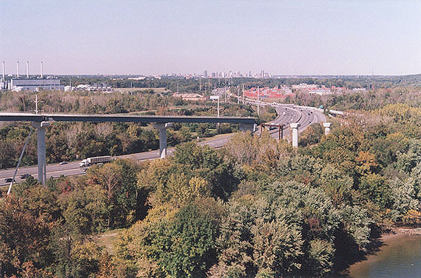
Above, I'm standing on the eastbound span of the main span of the Route 895 James River Bridge, near the center of the river, looking north. The elevated ramp under construction is Ramp H, the ramp from westbound Route 895 to northbound I-95. I-95 is visible as it passes to the north. Downtown Richmond in visible in the distance.
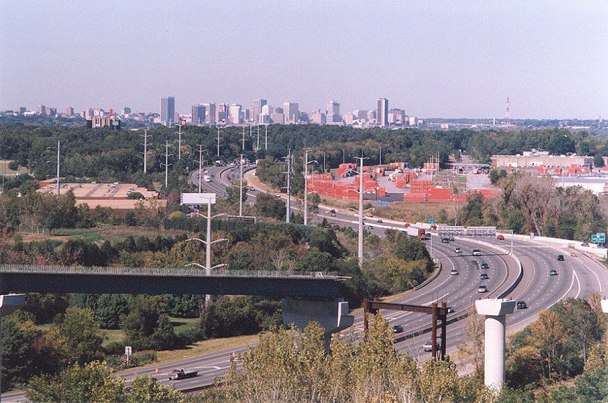
Above, I'm standing on the eastbound span of the main span of the Route 895 James River Bridge, near the center of the river, looking north. Same vantage point as the previous photo, taken a few minutes later, but with a 135mm (2.7x) telephoto lens instead of the 50mm regular lens used in previous photo; actually the human eye more closely approximates this long-distance view as seen from this moderate telephoto lens. Click for large image. The reddish objects are the cargo containers at the Richmond Marine Terminal, which is on the James River and handles ocean-going cargo ships. The marine terminal is upstream of the Route 895 James River Bridge, and is the reason for why the bridge has 145 feet of vertical navigational clearance over the river. Downtown Richmond in visible in the distance, 7 miles away. Seeing the downtown from this bridge was an unexpected treat for me, since I didn't realize until I was up there that it would be part of the vista from the bridge. I've always said that downtown Richmond has a rather impressive skyline for a city of its size, considering that it is a medium-sized city (200 thousand city population and 1 million metropolitan population).
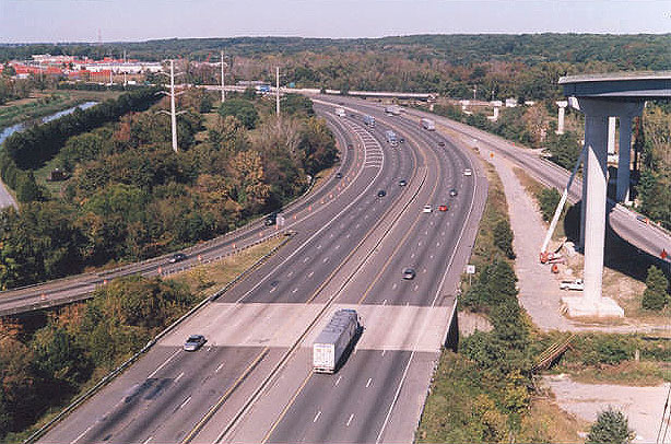
Above, I'm standing on the eastbound span of the west approach span of the James River Bridge, looking north. The bridge roadway passes almost 100 feet above I-95, since the closeness of the James River dictates that the approaches be this high; the river is parallel to and only a few hundred feet from I-95. The elevated ramp under construction is Ramp H, the ramp from westbound Route 895 to northbound I-95. I-95 is visible as it passes to the north. The lower ramps are the existing ramps to and from VA-150 Chippenham Parkway.
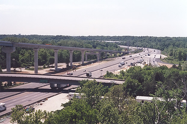
Above, I'm standing on the eastbound span of the west approach span of the James River Bridge, looking south. Again, it is apparent how high that Route 895 passes over I-95. The elevated ramp under construction is Ramp E, the ramp from northbound I-95 to eastbound Route 895. The lower ramp bridge is the existing ramp from southbound VA-150 to northbound I-95. The former Falling Creek Toll Plaza was just beyond the lower overpass bridge, and the wider pavement for the toll plaza is still in place on the right.
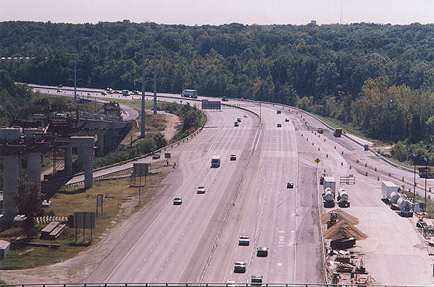
Above, I'm standing on the eastbound span of the west approach span of the James River Bridge, looking south. Same vantage point as the previous photo, taken a few minutes later, but with a 135mm (2.7x) telephoto lens instead of the 50mm regular lens used in previous photo. The elevated ramp under construction is Ramp E, the ramp from northbound I-95 to eastbound Route 895. These two photos to the south were taken against the sun, so the roadway appears overly bright. The I-95 bridges over Falling Creek are several hundred feet long, and are visible right before the highway's horizontal curve begins. The Falling Creek bridges were rehabilitated with complete replacement of superstructure (beams and deck) in a separate project (not part of the Route 895 project) and were completed in February 2001 in a $6.8 million project that included the short I-95 mainline bridge visible two photos above, just north of the Route 895 bridge. The Falling Creek bridges (there are indeed two, with a gap of about 6 inches between the two) have three through lanes and a right auxiliary lane and full shoulders on the northbound bridge, and three through lanes and two right auxiliary lanes and full shoulders on the southbound bridge. These bridge rehabilitations were part of the ongoing, mostly complete, program to rehabilitate bridges that were built as part of the Richmond-Petersburg Turnpike, which was opened in 1958 with six lanes north of Maury Street in Richmond, and with four lanes south of Maury Street, with the 22-mile section from Maury Street to I-85 in Petersburg (which includes the Falling Creek area) widened to six lanes 1974-1978. The inner two through lanes each way of the I-95 Falling Creek bridges were opened in 1958, and the outer through lane and auxiliary lane each way was opened in 1978; so much of these structures were over 40 years old and were in need of major rebabilitation. The rehab project did add one additional southbound auxiliary lane for Ramp G, the ramp from westbound Route 895 to southbound I-95.
Next page:
Route 895 Construction - October 2001 - Photos 21-24© Copyright 2001 by Scott Kozel, and all photos taken by same. All rights reserved.
Lead page for
Route 895 Construction - October 2001Lead page for Route 895 Construction
Lead page for Route 895 Connector
By Scott M. Kozel,
Roads to the Future(Created 11-16-01)