
| US-58 Widening and Bypasses in Mecklenburg County |
US-58 Widening and Bypasses in Mecklenburg County
Four-lane widening and relocation improvements have been completed in Mecklenburg County, Virginia, on 32.5 miles of US-58 from west of Clarksville to east of South Hill. The Clarksville Bypass groundbreaking ceremonies were held on June 29, 2000, and the bypass fully opened on June 9, 2005. The South Hill Bypass was opened on November 4, 1999, and the entire project was completed on August 2, 2000. The 4-lane 1.5-mile-long Boydton Bypass is complete; the first two lanes of the US-58 Boydton Bypass was built on a limited access 4-lane right-of-way and was opened in 1980, and the parallel roadway was completed in 1992. The rest of the existing 2-lane US-58 has been widened to 4 lanes divided by building a parallel 2-lane roadway, and by rebuilding the existing 2-lane roadway, and of that 22 miles, 19 miles was completed to 4 lanes from Summer 1998 to July 2001. One widening project was delayed due to funding, the 3.5 miles from 1/2 mile west of the US-1/US-58 intersection at Big Fork, to the west end of the South Hill Bypass, and this project was placed under construction in March of 2002, at a construction cost of $10 million, and it was completed in October of 2004.
Both roadways are 24 feet wide with 8-foot-wide paved right shoulders and 3-foot-wide paved left shoulders, and a standard 40-foot-wide median, with a wider median in a few places. The entire 32.5-mile-long corridor expansion is costing $244.5 million for engineering, right-of-way and construction. The completion of these projects means that US-58 is four lanes divided throughout for 232 miles, from west of Stuart in Patrick County, to I-64 in the City of Chesapeake. Ultimately the section of US-58 between Stuart and I-77 at Hillsville, will be rebuilt to four lanes divided.
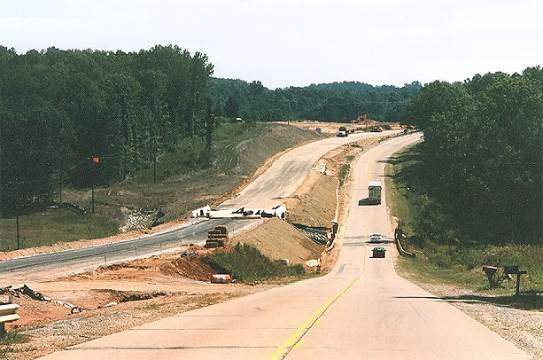
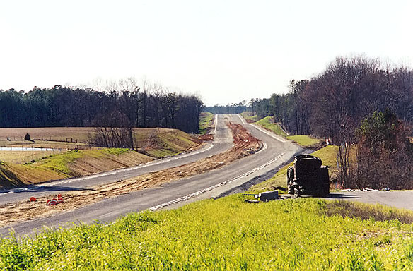
Above, looking eastbound, Long Branch bridges ahead; about 4 miles east of Boydton.
Construction of the new westbound roadway is in the stage of laying subgrade for
asphalt paving. Construction of the new westbound Long Branch bridge is complete.
Photo taken in September 1998. Click the photo for a May 1999 photo from the same
vantage point. A "drill down" sequence will take you through 6 photos showing the
phases of construction to the completion in 2000.
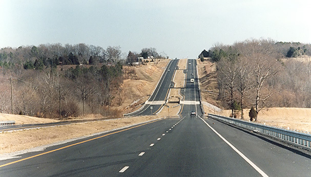
Above, looking eastbound, completed highway expansion, Cox Creek bridges ahead;
about 4 miles west of the US-1/US-58 intersection at Big Fork. Photo taken in February
2001.
The 3.5 miles of US-58 four-lane widening just west of South Hill cost of $10 million for construction. The speed limit is 55 mph throughout. Most of the project (about 2.7 miles) has five 12-foot-wide lanes, with the center lane for left turns only. The intersection with US-1 at Big Fork has been rebuilt so that US-58 is the through route, and US-1 curves and junctions at a T-intersection with US-58. The curve on US-58 at Big Fork has been built to a 55 mph design speed. From the US-1 intersection to the west end of the project (about 0.8 mile), the new highway has 4 lanes with a median 40 feet wide. The whole project has 10-foot paved right shoulders. Near the west end of the project, US-58 crosses Miles Creek, and a new westbound 2-lane bridge was built and the original 2-lane bridge was demolished and a new 2-lane bridge was built for eastbound traffic. The west end of the project seamlessly ties into the US-58 highway that was dualized in 2001. The east end of the project seamlessly ties into the 5.2-mile-long, $35.1 million US-58 South Hill Bypass that was opened in 2000.
US-58 Mecklenburg Widening and Bypasses - Photos - my article with construction photos of the widening projects and bypasses.
Clarksville Bypass
The 5.3-mile-long Clarksville Bypass is costing $103.3 million for construction, engineering and right-of-way, and it includes 11 bridges, including a 4,800-foot-long bridge over the John H. Kerr Reservoir (also known as Buggs Island Lake), a 492-foot-long bridge over the Clarksville small boat harbor, and twin bridges over the Occoneechee Harbor (Sandy Creek). The bypass passes just south of the town limits of Clarksville, and it is a 4-lane limited access highway, with interchanges at US-15 south of Clarksville and US-15 east of Clarksville, and two other at-grade intersections. The bypass carries US-58 and VA-49 along its whole length. Each transition from existing US-58 to the new bypass forms a continuous seamless highway from existing to new, with the existing highway being connected to the new via a T-intersection west of the town, and east of the town via a directional interchange that includes a flyover for westbound traffic. The project includes 1.0 mile of 4-lane reconstruction of US-58 west of the west end of the bypass, and 0.7 mile of 4-lane dualization east of the east end of the bypass, for a total project length of 7.0 miles.
A VDOT news release on April 20, 2000 announced the contract award for the entire Clarksville Bypass: "A $72.4 million contract was awarded to Morse Diesel Civil, LLC of Lawrenceville, NJ to build the Route 58 Clarksville Bypass in Mecklenburg County. The 5.1-mile limited access highway will extend from Route 722 to Route 15 North, and includes a new steel bridge over Buggs Island Lake. The project is funded under the Route 58 Corridor Development Program, and the scheduled completion is May 2003".
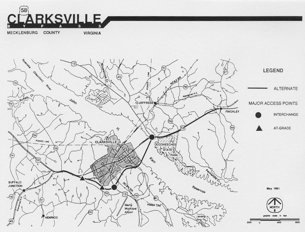
Above image is the Line 9 alignment for the Clarksville
Bypass, from VDOT Location Public Hearing brochure, June 11, 1991. This alignment
was presented as approved in the VDOT Design Public Hearing brochure, January 15,
1997. Click the image for a large version (204K) of image.
Route 58 Clarksville Bypass - VDOT webpage about the project.
Clarksville Bypass Project Website - www.clarksvillebypass.com. "This site contains information concerning the Route 58 Clarksville Bypass project located in Mecklenburg County Virginia. The Prime Contractor for this project is AMEC Civil LLC of Lawrenceville, New Jersey. The project is being constructed by the Virginia Department of Transportation, Richmond District, South Hill Residency. Greenhorne & O'Mara Inc., is providing Construction Inspection Services in conjunction with VDOT inspection personnel".
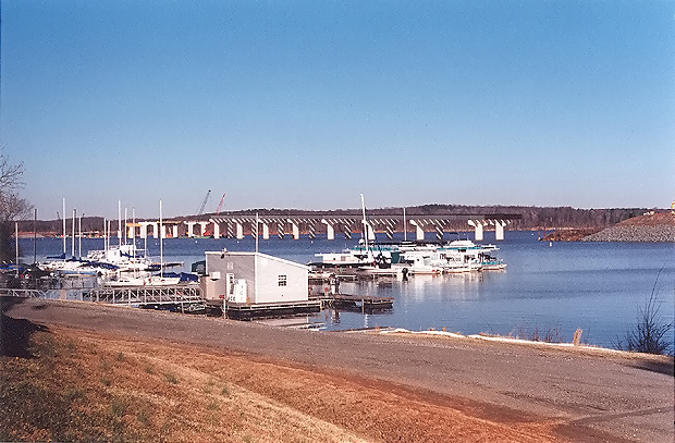
Above, the 4,800-foot-long bridge over Buggs Island Lake under construction as
part of the US-58 Clarksville Bypass, photo taken from the town of Clarkesville
in February 2003.
The 1.4-mile-long section of the bypass between US-58 west of Clarksville and US-15 south of Clarksville, opened to traffic in mid-2004, and the reconstruction was completed on the 1.0 mile of 4-lane reconstruction of US-58 west of the west end of the bypass. The existing 4-lane US-58 (that section which is being bypassed) was relocated onto a curved section where it connects to the new bypass west of town. US-58 was then temporarily signed through this intersection to follow all of the original US-58 through town.
The entire US-58 Clarksville Bypass was fully opened to traffic on June 9, 2005.
"Clarksville
Bypass to open to traffic Thursday morning",
Virginia Department of Transportation
news release, June 8, 2005. Excerpts follow (blue text):
US-58 Mecklenburg Widening and Bypasses - Photos - my article with construction photos of the widening projects and bypasses.
South Hill Bypass
The 5.2-mile-long $35.1 million South Hill Bypass construction was begun in March 1998, and it is a 4-lane limited access highway with a 60-mph design speed, passing south of the town. It has an at-grade intersection with existing US-58 west of town, a small interchange with VA-903 south of the town, and an at-grade intersection with existing US-58 in the east edge of the town. The interchange with I-85 was reconstructed with twin replacement US-58 bridges built over I-85, and new ramps and loops were added to convert the existing partial-cloverleaf (a half cloverleaf to the north of US-58) interchange to a full cloverleaf design. Each transition from existing US-58 to the new bypass forms a seamless continuous highway from existing to new, with the existing highway being tied to the new via a T-intersection.
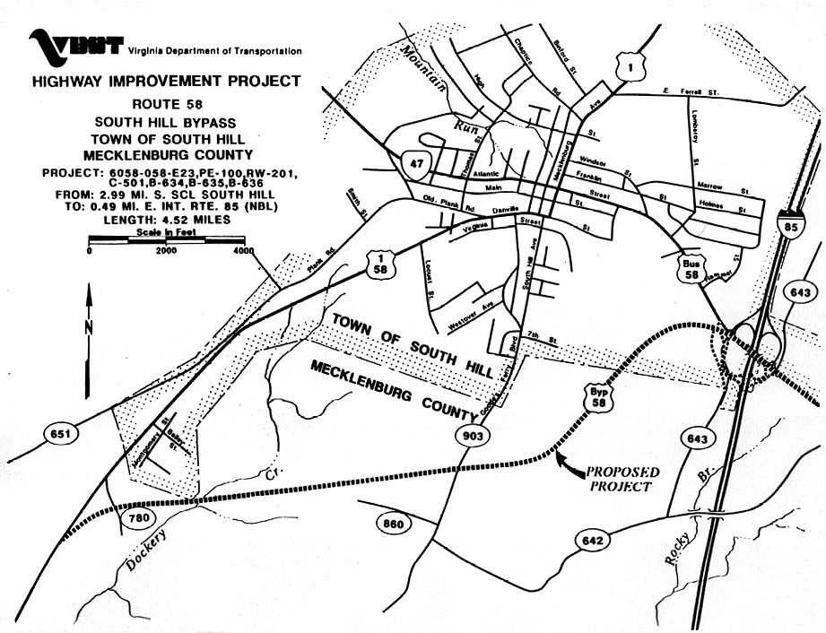
Above image is the approved alignment for the South
Hill Bypass, from VDOT Design Public Hearing brochure, September 14, 1995. Click
the image for a large version (144K) of image.
On Sunday, August 29, 1999, the newspaper Richmond Times-Dispatch had 3 good articles about the widening and bypasses being constructed on US-58 in Mecklenburg County, Virginia.
In the article "South Hill
sees only benefits from new road", South Hill Mayor Earl O. Horne said his town
has no fear of the bypass hurting the town in any way, and he was quoted. Excerpts
follow (in blue text):
"I really don't consider it a bypass," he said. "It
certainly helps that the bypass takes traffic around the downtown area, but ties
it back in easily within sight of the strip of businesses and restaurants near the
interstate", Horne said. "I have not heard the first merchant or anybody say this
is going to hurt us," he said. "If anything," he said, "the bypass could help downtown.
Now, all traffic traveling through South Hill on U.S. 58 must snake through town,
congesting roads and leaving traffic snarled. That often includes a number of tractor-trailer
trucks".
"Town celebrates completed road / Bypass eases South Hill traffic", newspaper Richmond Times-Dispatch,
on August 3, 2000, article about the opening of the South Hill Bypass. Excerpts follow
(in blue text):
With the completion of the South Hill bypass, truckers
and motorists have a quick route around the town and local traffic is less congested,
transportation officials said yesterday at a ribbon-cutting ceremony for the new
road.
Work on the 4.5-mile, $24 million bypass started in April 1998 and the bypass opened last November, eight months ahead of schedule. The road was surfaced in the spring and finishing touches were added in June.
"We built this project to meet the growing transportation needs of the town and long-distance travelers," said Dale Goodman, resident engineer with the Virginia Department of Transportation. "This bypass will carry us well into the future, accommodating increasing traffic volumes for decades to come."
The bypass was built to ease traffic congestion in downtown South Hill. The narrow road through town was the only path for heavy truck traffic to follow, often causing traffic tie-ups for motorists. The bypass makes travel in and around South Hill safer and more efficient and makes the town more accessible to tourists and residents, VDOT officials said.
The highway was paved with super-pave, a much tougher type of asphalt that will last longer than previous types.
The former route of US-58 through the town was slow and congested, and it made two right-angle turns through intersections in the downtown; this route is now signed as Business US-58. Actually the 1990 population of the town of South Hill was 4,217, and the population of Mecklenburg County was 29,241, so any "congestion" was small compared to a major city; basically it was just slow-going for several miles through the town with several traffic signals.
The bypass is signed only as US-58, but it in conjunction with I-85 also provides a bypass for US-1 traffic, and a bypass for traffic between US-58 west of South Hill and I-85 north of South Hill. The opening of the South Hill Bypass completes another key link in Arterial US-58 in Virginia, and it provides a big traffic improvement for the whole South Hill area.
Arterial highways in Virginia are 1,850 miles of intra-state highways that were designated in 1964 to be 4-laned with bypasses built around major towns, and over 90% of its mileage is complete today. With the completion of this bypass, US-58 between just west of South Hill and I-64 in the Norfolk/Hampton Roads area is now continuous Arterial standard, with 4-lanes-divided and with bypasses around South Hill, Lawrenceville, Emporia, Courtland, Franklin, Holland, and Suffolk.
The entire South Hill Bypass project was completed on August 2, 2000, when the improvements to existing US-58 at the east end of the bypass were completed, and the improvements to the I-85/US-58 interchange were completed. This provides a big improvement, with through traffic now on the high-speed bypass, and the Business US-58 now with lighter, more pleasant traffic conditions on the original US-58 through-town route.
Above, South Hill Bypass under construction, April 1999,
looking west from near VA-903 overpass over US-58. Roadways have been graded and
aggregate base has been placed. Click photo for June 1999 photo from the same vantage
point. A "drill down" sequence will take you through 2 more photos showing the phases
of construction to the completion in 2000.
US-58 Mecklenburg Widening and Bypasses - Photos - my article with construction photos of the widening projects and bypasses.
| US-58 Summary from VDOT 6-Year Program FY 2002-2007 | |||
| Section (listed from west to east) |
Length (miles) |
Cost $ millions |
|
| Clarksville Bypass and approaches | 5.3 | 103.3 | |
| Dualization from east of Clarksville to west of South Hill | 22.0 | 106.1 | |
| South Hill Bypass | 5.2 | 35.1 | |
| TOTAL | 32.5 | 244.5 | |
U.S. Route 58 Corridor Development Program
U.S. Route 58 Corridor Development Program, on VDOT's website. It has detailed information about the corridor project. Excerpts (in blue text):
Project Description - The Route 58 Corridor Development Program is a construction project that encompasses close to 680 miles and finances planning, environmental and engineering studies, right of way, and construction. Today, about 370 miles are four lanes or more, compared to 240 miles when the Program started. Work began on the east coast and is moving westward.
Project Origination - The Virginia General Assembly established the Route 58 Corridor Development Program in 1989 to enhance economic development potential across this largely rural portion of the state. Travel is being improved on the mostly two-lane, winding and hilly road, and most work is now completed through Henry County.
History - Route 58 is Virginia's longest roadway stretching from the Atlantic Ocean to the southwest tip of Virginia. It traverses five VDOT districts - Hampton Roads, Richmond, Lynchburg, Salem and Bristol.The U.S. Route 58 Corridor Development Program was begun by the enactment of 1989 legislation of the General Assembly of the Commonwealth of Virginia. The US-58 highway runs 508 miles across the entire southern tier of Virginia, from Cumberland Gap to Virginia Beach. It runs through 14 counties and 4 cities. Economic studies showed that most of these mostly rural counties had local economies that were stagnant, with higher unemployment rates than the state average, and with lower rates for growth in income and wealth than the state average. Partial or full lack of modern 4-lane highway service was identified as a major cause for the economic conditions, and studies showed clear justification in the benefits of an investment of $600 million or more to bring the US-58 corridor (nearly half of which was 2-lanes in 1989) up to modern 4-lane arterial standards. General obligation bonds issued by the state are the means of financing this program.
The purpose of the U.S. Route 58 Corridor Development Program is to create an adequate, modern, safe, and efficient highway system connecting the communities, businesses, places of employment, and residents of the southwestern-most portion of the Commonwealth to the same in the southeastern-most portion of the Commonwealth, and to those throughout the corridor. The U.S. Route 58 Corridor Development Fund of the Transportation Trust Fund is supported from the annual deposit of the first $45.5 million of the real estate recordation tax revenue collected by the state Treasurer. The goal of the program is to enhance the economic development potential, employment opportunities, mobility and quality of life along the U.S. Route 58 corridor.
The Virginia Transportation Development Plan for 2000-2001, in the U.S. Route 58 Corridor Development Program summary lists a financial summary of the US-58 corridor program. There are $704.3 million in Bonds Issues Authorized, $397.0 million in Bonds Issues Sold, $307.3 million in Future Bond Issue Sales. To date, $616.1 million in bond funds and highway construction allocations have been dedicated to the corridor. An additional $852.8 million has been identified in the "Balance to Complete" category with no funds programmed.
There is an updated financial summary of the US-58 corridor program in the VDOT Route 58 Newsletter - Winter 2001. Excerpt in blue text:
The Commonwealth Transportation Board has issued $704.3 million worth of bonds for improvements under the U.S. Route 58 Corridor Development Program. Approximately $714 million has been spent for improvements. All the bonds previously authorized for the program have been issued. In the Virginia Transportation Act of 2000, $229.3 million from transportation revenue sources is designated for this program.Sources: Commonwealth Transportation Board 6-Year Improvement Program for Fiscal Years 1991-1996, 6-Year Improvement Program for Fiscal Years 1999-2004, Six-Year Improvement Program for Fiscal Years 2000-2005, Six-Year Improvement Program for Fiscal Years 2002-2007, and VDOT project location and design public hearing brochures for the US-58 projects.
Photos by Scott Kozel unless otherwise noted.
Copyright © 1999-2005 by Scott Kozel. All rights reserved. Reproduction, reuse, or distribution without permission is prohibited.
By Scott M. Kozel, Roads to the Future
(Created 3-15-1999, updated 9-1-2005)