
| Woodrow Wilson Bridge (I-495 and I-95) |
Article index with links:
Woodrow Wilson Bridge Construction Photos
Woodrow Wilson Bridge Project Segment Openings
Woodrow Wilson Bridge Project Wins Top Civil Engineering Award
Woodrow Wilson Bridge Improvement Study
High-Level Bridge and Tunnel Alternatives
Rail Transit Proposals Across Woodrow Wilson Bridge
Woodrow Wilson Bridge Project Website
Woodrow Wilson Bridge Project Cost and Funding
Washington Post - Articles and Links
New Woodrow Wilson Bridge Clears Legal Hurdles
Woodrow Wilson Bridge Ownership
Woodrow Wilson Bridge - Construction
Woodrow Wilson Bridge Redecking in 1983
Woodrow Wilson Bridge Structural Problems
Legend
Overview of Woodrow Wilson Bridge
The Woodrow Wilson Memorial Bridge was named after President Woodrow Wilson, who was born in Staunton, Virginia. The Woodrow Wilson Bridge is one of seven highway facility crossings over the Potomac River within the Washington, D.C. metropolitan area. It carries the I-95/I-495 Capital Beltway (see Roads to the Future article for more details on the whole Beltway) over the Potomac River at Alexandria, Virginia. The bridge has its west abutment in Virginia, and its east abutment in Maryland, and about 100 feet of the mid-span portion of the bridge crosses the tip of the southernmost corner of the District of Columbia. The original bridge had 6 lanes, it was 5,900 feet long, it was opened to traffic in 1961, and it formed the southern Potomac River crossing for the Capital Beltway. A 25-foot deep shipping channel is about 500 feet from the Virginia shoreline, and a high-level bascule drawspan allows large marine traffic to pass. The original drawspan was comprised of 4 bascule leaves, each with a steel grid deck roadway. The drawspan had 50 feet of vertical navigational clearance when closed, and it had 175 feet of horizontal navigational clearance. The remainder of the bridge was comprised of 31 long spans each averaging about 184 feet long, with continuous steel girders and the roadway deck on top. Because the shipping channel is close to the Virginia shoreline, about 2,000 feet of the bridge is over land in Virginia. The Potomac River in this area ranges from 3/4 to 1 mile wide.
 |
Roads to the Future took this photo of the Woodrow Wilson Bridge while standing on the Virginia shoreline, in February 2001. The floating construction equipment near the main span is associated with work on the existing bridge deck. Click image for fullsize image. |
The construction of the original 5,900 foot long southern Potomac River crossing at Alexandria was authorized by the U.S. Congress on August 30, 1954, to be built and 100% funded by the federal government. It was initially named the Jones Point Bridge, and was officially named the Woodrow Wilson Memorial Bridge, on May 22, 1956. Excerpts from "Why is the Woodrow Wilson Memorial Bridge Named after Woodrow Wilson?", by the Rambler, a historian of FHWA (Federal Highway Administration).
On August 30, 1954, President
Dwight D. Eisenhower signed Public Law 83-704, "An Act to authorize and direct
the construction of bridges over the Potomac River, and for other purposes." One
provision stated:
The Secretary of the Interior . . . is authorized and directed
to construct, maintain, and operate a six-lane bridge over the Potomac River,
from a point at or near Jones Point, Virginia, across a certain portion of the
District of Columbia, to a point in Maryland, together with bridge approaches
on property owned by the United States in the State of Virginia.
The sum of $14,925,000 was authorized to be appropriated for the Jones Point Bridge. However, the cost of the approaches and improvements to collateral streets and highways was to be borne by the States of Maryland and Virginia:
The Secretary shall not begin construction of the bridge . . . until the State of Virginia and the State of Maryland have taken such steps as the Secretary deems adequate to give assurances that there will be constructed and maintained, by and in such States, such approaches to such bridge as will be reasonably adequate to make possible the full and efficient utilization of such bridge.
On May 22, 1956, President Eisenhower signed Public Law 84-534, which transferred responsibility for the project to the Secretary of Commerce, whose Department included the Bureau of Public Roads (BPR). The same day, the President signed Public Law 84-535, which renamed the "Jones Point Bridge" the "Woodrow Wilson Memorial Bridge."
Construction began on the Woodrow Wilson Memorial Bridge in 1958. The six-lane Potomac River bridge and 3.2 miles of six-lane Beltway between US-1 Jefferson Davis Highway in Virginia and MD-210 Indian Head Highway in Maryland, opened to traffic on December 28, 1961. The bridge is most commonly publicly referred to by the shorthand name versions of Woodrow Wilson Bridge or Wilson Bridge.
FHWA By Day,
December 28, 1961, excerpt (blue text):
Secretary of Commerce Luther
Hodges, Administrator Rex Whitton, NPS Director Conrad Wirth, and State and local
officials participate in a ceremony opening the 5,900-foot Woodrow Wilson Memorial
Bridge, which will carry Capital Beltway traffic across the Potomac River. Mrs.
Woodrow Wilson, widow of the President, was to have unveiled a plaque in the memory
of her husband, but she is gravely ill. The bridge, which spans three jurisdictions
(Maryland, Virginia, and the District of Columbia), was authorized when President
Dwight D. Eisenhower approved House Bill 83-704 on August 30, 1954. In 1958, BPR
began construction, which involved 13 contracts. The total cost of the bridge
was $14 million. Only short sections of the beltway on either side of the bridge
are open, but traffic on the bridge quickly reaches 18,000 vehicles per day.
See the link for an original photo of the Woodrow Wilson Bridge
(I-95/I-495 southern Potomac
River crossing).
The original Woodrow Wilson Memorial Bridge construction is documented here
with 14 photos on the official Woodrow Wilson Bridge Project website,
Project Scrapbook - Past Photographs Original Construction. [[[ the
WWB project website has been deleted from internet ]]]
By 2000, almost the entire I-495 Capital Beltway
had been widened 8 lanes since it was completed in 1964. The only remaining 6-lane
section, other than the 3-mile section between the two wyes of I-270, was the Woodrow
Wilson Bridge (WWB) and approaches, 2.1 miles from US-1 in Virginia to I-295 in
Maryland. Design and construction was undertaken to widen the WWB and approaches.
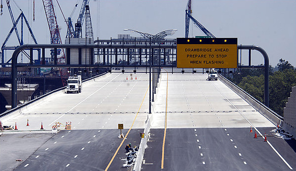
Drawbridge openings on the original bridge often caused severe traffic jams. The
bridge carried over 200,000 vehicles per day and was congested. The bridge was
originally opened to traffic on December 28, 1961, and it was completely redecked
(roadway deck replaced) in 1983,
with enough widening to provide 7-foot emergency shoulders on the right of each
roadway, wide enough for a disabled car. The specter of another major rehabilitation
was approaching, as the car and truck traffic far exceeded the 75,000 vehicle per
day original design of the bridge. Alternatives examined for expansion included
a fixed high-level (main span with 135 feet of vertical navigational clearance)
bridge, or a new drawbridge, or a tunnel, and the 1992 cost estimates for the
various alternatives ranged from $1.4 to $3.5 billion, the tunnel alternative
being the most expensive one. There were aesthetic concerns from Old Town Alexandria
residents about the fixed high-level bridge alternative, and major cost and
operational concerns from most parties about the tunnel alternative.
The alternative chosen by the local governmental and public involvement process, and the state and federal DOTs (FHWA, VDOT, MDOT SHA, and DDOT), was to build a new 12-lane twin-span Potomac River Bridge, with twin bascule spans with 70 feet of vertical navigational clearance when closed, and widened 12-lane dual-divided beltway for several miles on each approach, for a total of 7.5 miles of Beltway reconstruction. The additional 20 feet of main span vertical navigational clearance will reduce drawbridge openings by two-thirds. The cost of this alternative was projected to be $2.4 billion, with $830 million for the bridge itself. Construction began on October 20, 2000, and the first new 6-lane Potomac River Bridge opened to traffic in mid-2006, and the second new 6-lane Potomac River Bridge opened to traffic in mid-2008, with the rebuilt Beltway approaches ready to match the new Potomac River Bridge when it was complete, between west of the U.S. Route 1 Interchange in Virginia and east of the MD-210 Indian Head Interchange in Maryland. It was early 2009 before all mainline Beltway lanes were open on those segments. The remaining Beltway reconstruction including the VA-241 Telegraph Road Interchange, was placed under construction in early 2008, and was completed in early 2013.
The new twin-span Potomac River bridge has the same name as the original bridge, the Woodrow Wilson Memorial Bridge.

New drawspan, click for larger images. Courtesy of
Aecom.
Courtesy of
Hardesty and Hanover.

New bridges, notice pedestrian/bikeway, click for larger images.
Courtesy of Cycles of Life
Washington Street Urban Deck
Courtesy of
Aecom
Courtesy of
Corman Construction


Night photos February 2009 by the Virginia Department of Transportation
Day photo by Roads
to the Future
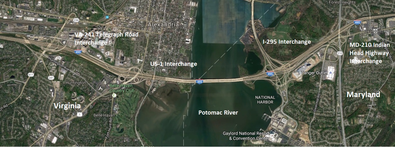 |
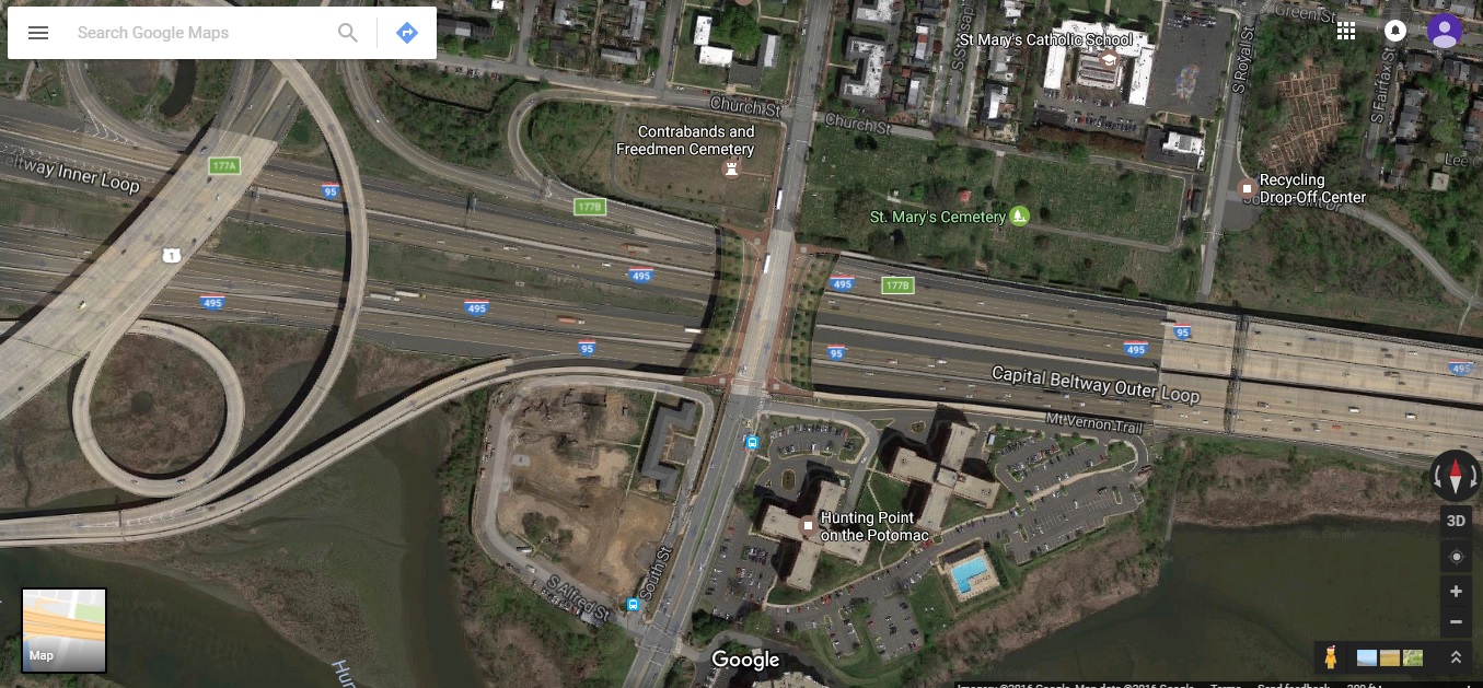
Aerial
photo of Woodrow Wilson Bridge Project area, extracted in November 2016, taken by Google Maps. Click image for fullsize image. |
 |
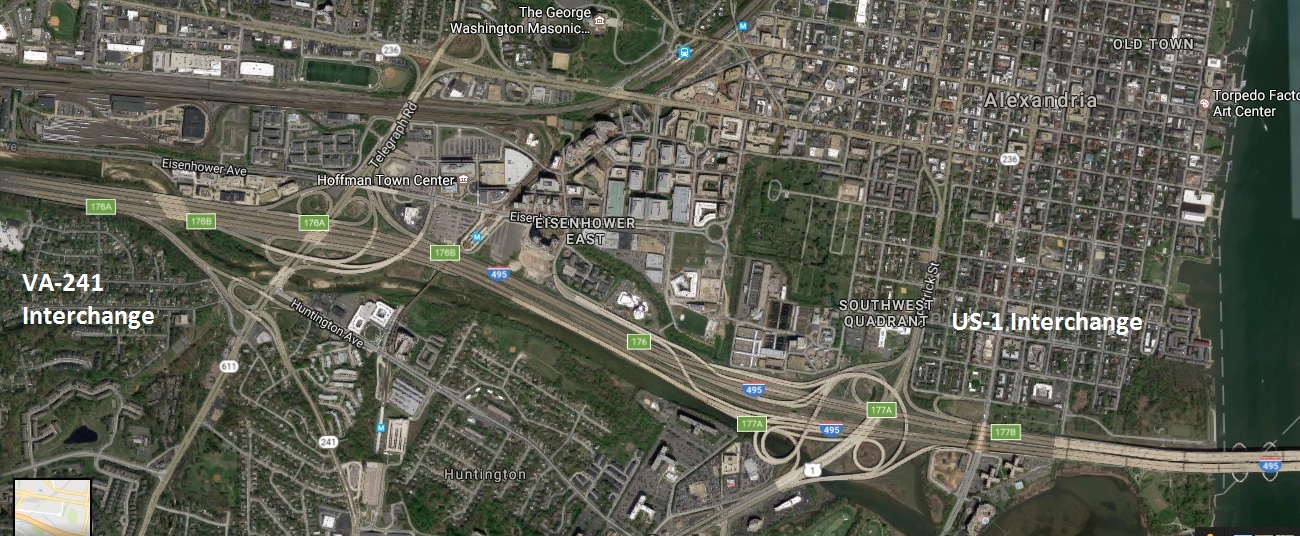
Aerial
photo of Woodrow Wilson Bridge Project area, Eisenhower Avenue Connector
and VA-241 interchanges, extracted in
December 2016, taken by Google Maps. Click image for fullsize image. |
 |
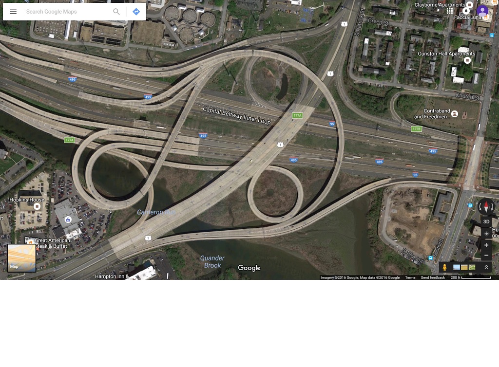
Aerial
photo of Woodrow Wilson Bridge Project area VA-241 and US-1 interchanges, extracted in
December 2016, taken by Google Maps. Click image for fullsize image. |
 |
Aerial
photo of completed US-1 Interchange, extracted in November 2016, taken by
Google Maps. Click image for fullsize image. |
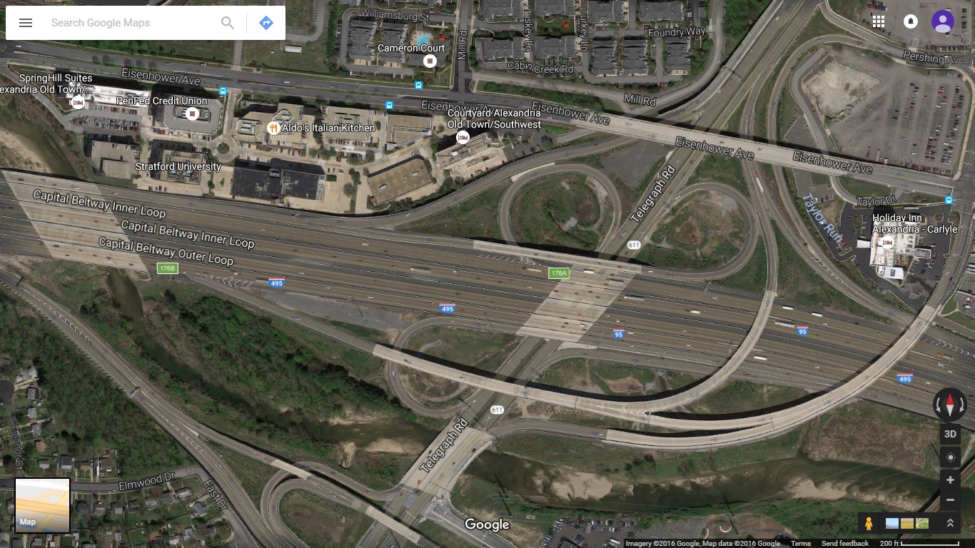 |
Aerial
photo of completed VA-241 Interchange, extracted in November 2016, taken by Google Maps. Click image for fullsize image. |
 |
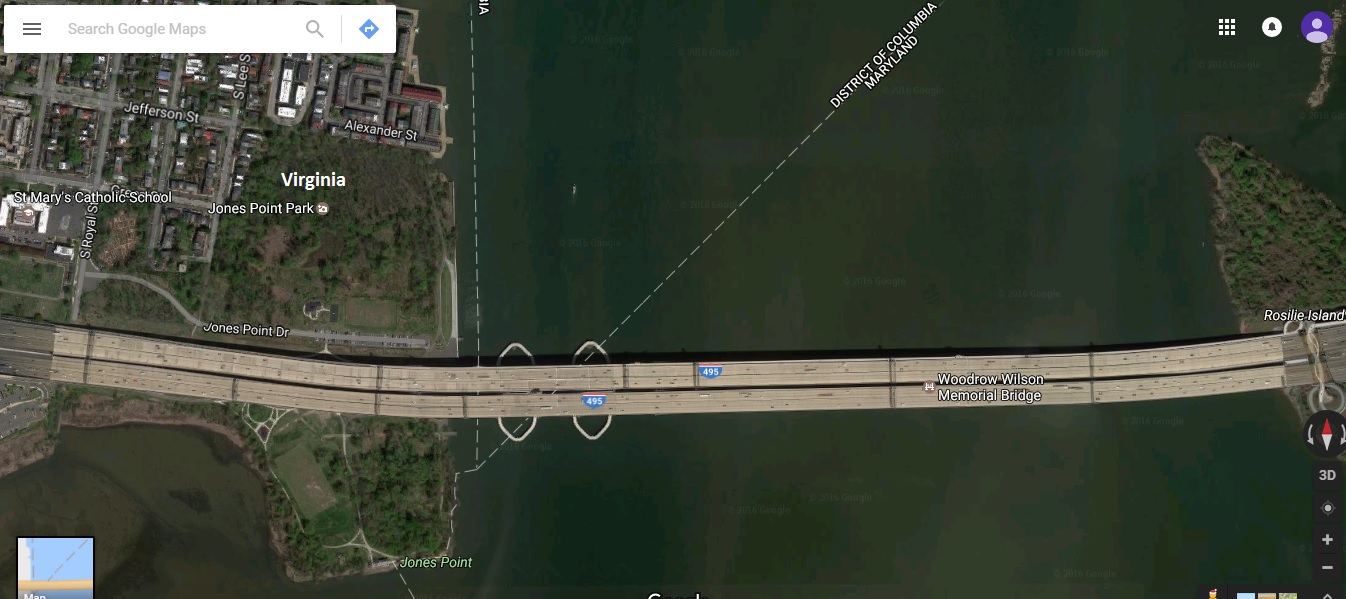
Aerial
photo of Woodrow Wilson Bridge, Washington Street Urban Deck area, extracted in
December 2016, taken by Google Maps. Click image for fullsize image. |
 |
Aerial
photo of Woodrow Wilson Bridge area, extracted in
December 2016, taken by Google Maps. Click image for fullsize image. |
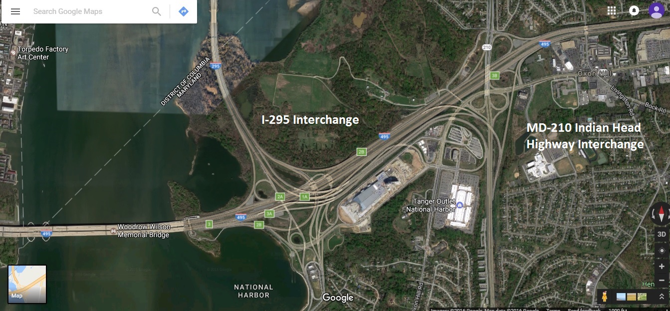 |
Aerial
photo of Woodrow Wilson Bridge Project area, I-295 and MD-210 Indian Head
Highway interchanges, extracted in
December 2016, taken by Google Maps. Click image for fullsize image. |
 |
Aerial
photo of completed I-295 Interchange, extracted in November 2016, taken by Google Maps. Click image for fullsize image. |
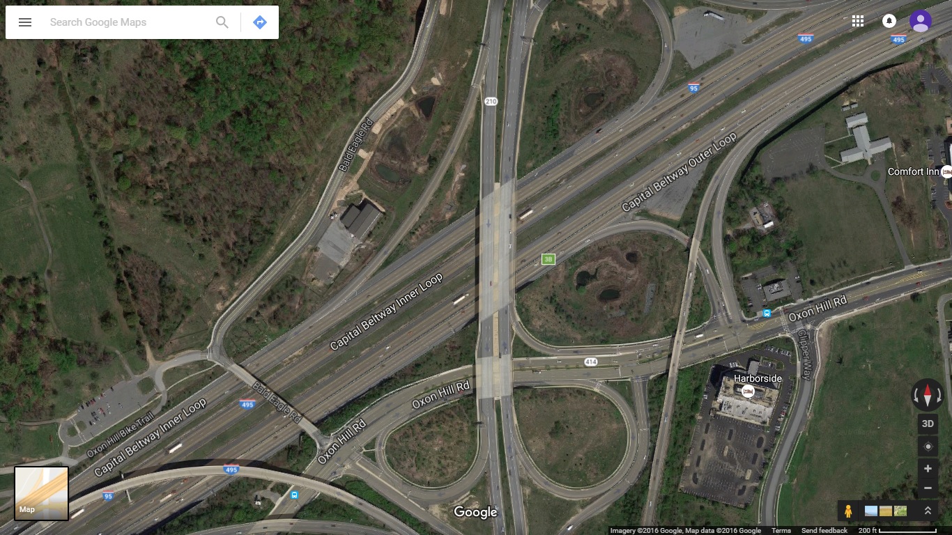 |
Aerial
photo of completed MD-210 Interchange, extracted in November 2016, taken by Google Maps. Click image for fullsize image. |
Woodrow Wilson Bridge Construction Photos
The following Capital Beltway dot com website article has links
to photo articles with detailed descriptions of the construction of the Woodrow
Wilson Bridge Project. All Woodrow Wilson Bridge Project photo articles, including
the following photo article directory webpage, are on Capital Beltway dot
com. The main Woodrow Wilson Bridge Project article is on Roads
to the Future. Both websites are developed by the same author.
Woodrow
Wilson Bridge Project Photos on Capital Beltway dot com
Last update -
June 23, 2012
Capital Beltway dot com is the Capital Beltway projects annex to Roads to the Future.
Woodrow Wilson Bridge - Selected Construction Aerial Photos - 18 large aerial images taken by VDOT during construction.
Woodrow Wilson Bridge - Photos of Original Bridge - 7 photos of the underside of the bridge on the Virginia land approach.
Woodrow Wilson Bridge Project Segment Openings
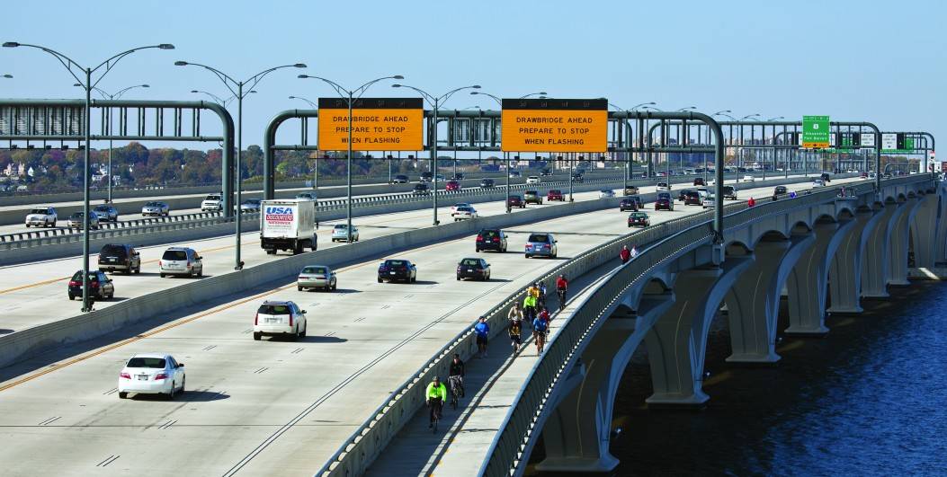
The Capital Beltway terms “Inner Loop” and “Outer Loop” are used for directional guidance, with “Inner Loop” for the clockwise-running roadway, and “Outer Loop” for the counterclockwise-running roadway. Looking at the Beltway on a map from above, the loop of the clockwise-running roadway is inside of the loop of the counterclockwise-running roadway, hence the terms “inner” and “outer” for the concentric roadways of the Beltway. With the original 6-lane Woodrow Wilson Bridge, the Outer Loop was the 3-lane Maryland-bound roadway, and the Inner Loop was the 3-lane Virginia-bound roadway. The new 12-lane twin-span Woodrow Wilson Bridge has a 6-lane Outer Loop (Maryland-bound) bridge with a pair of 3-lane roadways, and 6-lane Inner Loop (Virginia-bound) bridge with a pair of 3-lane roadways.
Opening of New 6-lane Outer Loop Potomac River Bridge
The first new 6-lane Woodrow Wilson Bridge was opened to traffic in two stages. It opened to traffic in June and July of 2006, and it was configured for 3 lanes each way until the 6-lane bridge for the Inner Loop of the Beltway opened to traffic in mid-2008. The new Outer Loop 3-lane local roadway, upon opening in June 2006, served temporarily as the 3-lane Outer Loop main roadway; until the second new 6-lane bridge opening in mid-2008, and other associated land approach construction allowed the opening of the new Outer Loop 3-lane express roadway. The new Outer Loop 3-lane express roadway, upon opening in July 2006, served temporarily as the 3-lane Inner Loop main roadway, until the second new bridge opened in mid-2008. It took a weekend of reconstruction at both approaches to connect the new bridge to the I-95/I-495 Capital Beltway. The first weekend was June 9-11, 2006, where the 3-lane Outer Loop roadway of the new bridge was opened to traffic, and the second weekend was July 14-17, 2006, where the 3-lane Inner Loop roadway of the new bridge was opened to traffic.
The roadway line painting of the new bridge Outer Loop 3-lane local roadway was in its final configuration, with a solid yellow line 6 feet from the left parapet, a solid white line 10 feet from the right parapet, and two white dashed lines separating the 3 lanes of traffic.
The initial roadway line painting of the new bridge Outer Loop 3-lane express roadway was in a temporary configuration, since it handled Inner Loop traffic for 24 months in the reverse direction of its final configuration. Heading in the Virginia-bound direction, it had the above format, with a solid yellow line 6 feet from the left parapet, a solid white line 10 feet from the right parapet, and two white dashed lines separating the 3 lanes of traffic. After the second new bridge opened to traffic in mid-2008, that 3-lane roadway was permanently reversed to handle Maryland-bound express traffic, so before it opened in its permanent format, the roadway paint lines were removed so that it can be repainted in the correct format for Maryland-bound traffic.
After the traffic was removed from the original Woodrow Wilson Bridge in July 2006, it was demolished and removed, in stages over a year. The western end of the new 6-lane Inner Loop bridge completely occupies the site of the western end (several hundred yards length) of the pre-existing bridge, so that section of the pre-existing bridge did need to be completely removed before that section of the new Inner Loop bridge could be built. That demolition needed to happen quickly, because the foundations for that segment of the new 6-lane Inner Loop bridge had not yet been able to be built, and the westernmost segment of the new Inner Loop bridge was on the critical path for completing the new Inner Loop bridge. All 34 of the foundations for the 6-lane Outer Loop bridge, and all 23 of the foundations for the Inner Loop bridge that did not not interfere with the pre-existing bridge, were built in the $125 million Foundations Contract that was completed in July 2003. There were 10 Inner Loop bridge foundations on the Virginia Approach Contract, and one foundation on the Maryland Approach Contract, that remained to be built as part of those contracts, after those portions of the pre-existing bridge were removed.
 |
New Woodrow Wilson Bridge, looking across bridge from Virginia toward Maryland. Photo taken by VDOT in early June 2006 right before opening. |
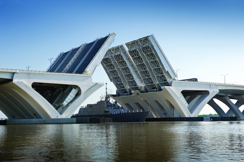
"First
Woodrow Wilson Bridge Dedicated", Virginia Department of Transportation news
release, May 18, 2006. Excerpt (in blue text):
The first new Woodrow Wilson
Bridge across the Potomac River was dedicated today at a star-spangled ceremony
attended by more than 1,400 dignitaries and guests. The highlight of the day was
a “Uniting the States” handshake at the midpoint of the new bridge. It followed
the closure of the bridge’s 150-foot drawspan, which physically links Virginia,
Maryland and the District of Columbia.
"Commute's
New Dawn: The Path to New Wilson Span, and What Lies Ahead", Washington
Post, May 14, 2006. Excerpt (in blue text):
About 11 a.m. Thursday, a new
drawbridge half as heavy as the Eiffel Tower will be lowered over the Potomac
River and the governors of Virginia and Maryland will walk from opposite shores
to shake hands, signaling a new era for hundreds of thousands of commuters. The
transformation will be brought on by the opening next month of the first of two
spans of the new Woodrow Wilson Bridge, a muscular hunk of 25,000 tons of concrete
and more than 30,000 tons of steel nearly two difficult decades in the making
that promises to ease drives across the area -- at least for a while. In a politically
complex region that rarely agrees on how to solve its severe traffic problems,
the bridge construction stands out as a success story. When the entire project
is completed, Virginia and Maryland leaders will have joined hands to refashion
12 percent of the Capital Beltway and unclog the area's worst bottleneck. Travelers
will enjoy some easier trips when the first span opens to the public June 9, but
the real benefits will come in two years, after a second six-lane span is completed.
Together, they are likely to erase the miles-long jams synonymous with the Wilson
Bridge -- hard as that may be for drivers to envision -- while alleviating congestion
on several other river crossings.
"New
Wilson Bridge Opened With Fanfare", Washington Post, May 18,
2006. Excerpt (in blue text):
The festivities began at 11
a.m. with the lowering of the gigantic drawbridge. Virginia Gov. Timothy M. Kaine
(D) and U.S. Transportation Secretary Norman Y. Mineta walked across from the
Virginia shore and were met halfway by Maryland Gov. Robert L. Ehrlich Jr. (R)
and District Mayor Anthony A. Williams (D), coming from the Maryland side. Then
the four of them got in the classic automobile and drove across the bridge. "This
is a magnificent new bridge," Mineta told the invitation-only crowd of nearly
1,000 members of Congress, local officials, construction workers and area residents.
"This bridge does show us that great things can happen when we all work together.
Thank you for a job well done." The Navy's Blue Angels soared overhead to
kick off the event.
The I-95/I-495 Capital Beltway 3-lane Outer Loop (Virginia to Maryland) roadway was shifted to the new bridge on the weekend of June 9-11, 2006, with all lanes opened to traffic on Sunday, June 11th.
"Woodrow Wilson Bridge: Three New Lanes Open",
Washington Post, June 11, 2006. Quote (in blue text):
At 7:45 a.m. Sunday [June 11th], all three lanes of northbound I-95/Capital Beltway
Outer Loop were restored across the first new Woodrow Wilson Bridge, replacing
the one-lane situation that was implemented at 9:30 p.m., Friday. The lane re-opening
occurred ahead of the project's schedule, which had a worst-case scenario of reopening
at 5 a.m., Monday. At 9:41 p.m. Saturday [June 10th], project officials said,
the first public vehicles rolled across the new Wilson Bridge in the single lane.
A Toyota Corolla carrying Ted Shin of Elkridge, Md., was the first to cross the
bridge. During the brief total closure to implement the switchover, the project
presented the first six crossers with coins specially minted commemorate the opening
of the bridge. Construction of the new Woodrow Wilson Bridge began in October
2000. In five weeks, I-95 South/Beltway Inner Loop will be switched onto the first
new bridge. Occurring during the weekend of July 14-17, the operation will be
mirror image of this weekend's work: I-95 South will be reduced to a single lane
and several ramps will be closed.
The I-95/I-495 Capital Beltway 3-lane Inner Loop (Maryland to Virginia) roadway was shifted to the new bridge on the weekend of July 14-16, 2006, with all lanes opened to traffic on Sunday, July 16th.
All Three Lanes of I-95 South Reopened on New Wilson Bridge, WWB Project News
Release, July 16, 2006. Excerpts (in blue text):
Oxon Hill, Md./Alexandria, Va. – At 12:01 a.m., Sunday, July 16, all three lanes
of southbound I-95/Capital Beltway Inner Loop were restored and are now traveling
across the new Woodrow Wilson Bridge, replacing the one-lane condition that was
implemented at 8:00 p.m., Friday, July 14. The lane reopening occurred 29 hours
ahead of the project’s schedule, which had a worst-case scenario of reopening
at 5:00 a.m., Monday morning. Completion of this second half of the traffic switch
completes the transfer of all six lanes to the new bridge.
Previously, at 2:28 p.m., Saturday, July 15, a Toyota Camry carrying Paul Chang of Mechanicsville, Virginia was the very last of approximately 73 billion vehicles ever to travel across the old bridge. Immediately following, the single lane of I-95 South/Inner Loop was switched from the old bridge onto the new bridge. Mr. Chang and four other final crossers of the old bridge were presented with coins specially minted to commemorate the opening of the new Wilson Bridge. Construction of the new Woodrow Wilson Bridge began in October 2000.
This weekend’s completion of the
new bridge traffic switch represents a major milestone for the traveling public
and the Wilson Bridge Project, as efforts will now shift to removing the old bridge
and completing the second new bridge span, which is scheduled to open in mid-2008.
"Old
Wilson Bridge Dec. 28, 1961-July 15, 2006 - From Its Hapless Beginning, Span's
Reputation Only Fell", Washington Post, July 15, 2006. Excerpt
(in blue text):
Were it a child, people would
lower their heads, shake them from side to side and say with all due sympathy:
The Woodrow Wilson Bridge was just born bad. Nothing ever went right for poor
little Wilson, which is leaving this world for good today after antagonizing nearly
every single one of the billions and billions of drivers who crossed during its
45 traffic-choked years. The bridge got off to an inauspicious start when Woodrow
Wilson's widow, Edith, the intended guest of honor at the dedication ceremony
Dec. 28, 1961, died that morning at age 89. Things went downhill from there. The
day, chosen because it was the 105th anniversary of the former president's birth,
was so bitter cold and windy that all anyone wanted to do was to get the ceremony
over with and get inside as quickly as humanly possible. In a sign of things to
come, the last place anyone wanted to be was on the Wilson Bridge.
The Wilson Bridge was one of the biggest bottlenecks on one of the most heavily
used interstates in the nation, made even worse when its drawbridge opened. Its
legacy will surely be its never-ending, never-yielding workday jams. Not so much
the historic jams, like the jumper of '98 or the Veterans Day snowstorm of '87,
but the day-in, day-out, no-way-around-it, please-Lord-let-me-get-to-the-other-side
congestion.
The bridge lasted a pitiful 45 years -- only a couple of millennia shy of some
of the spans built by the ancient Romans. The Brooklyn Bridge has been going strong
since 1883, the Francis Scott Key Bridge opened in 1923 and the Arlington Memorial
Bridge has been around since 1932. The Rolling Stones have lasted longer. The
Wilson Bridge did manage to outlast one other major structure built in 1961: the
Berlin Wall. Like the wall, part of the bridge will come down piece by piece over
the next few months. The rest will come down next year, after serving as a staging
ground for construction of the new span.
It was a bridge only a mother could love. Or maybe a father. Dan Appel was one
of the principal designers, and he declared it a winner.
See the link for the rest of the article.
Opening of New 6-lane Inner Loop Potomac River Bridge
Construction the new 6-lane Inner Loop bridge for the Woodrow Wilson Bridge, was completed in mid-2008.
The I-95/I-495 Capital Beltway 3-lane Inner Loop (Maryland to Virginia) roadway was shifted from its temporary location on the the new Outer Loop bridge, to the 3-lane local roadway of the new Inner Loop bridge, on the weekend of May 30 to June 1, 2008, with all lanes opened to traffic on Sunday, June 1st.
Along with this opening, the new 3-lane Inner Loop local roadway was opened to traffic from the Inner Loop WWB, through/under the Washington Street Urban Deck, to the US-1 interchange area; and that seamlessly connected to the new segment of 3-lane Inner Loop local roadway that was opened to traffic on May 11, 2008, from a few hundred feet west of the Washington Street Urban Deck, through the US-1 interchange area, to just east of the VA-241 Telegraph Road interchange. As a result of these openings, all Beltway Inner Loop traffic was operating on the new 3-lane Beltway Inner Loop local roadway, constructed throughout these segments of the WWB Project -- MD-210 interchange, I-295 interchange, Potomac River bridge, and US-1 interchange; which is the entire WWB Project except for the VA-241 interchange segment which began construction in early 2008.
This Inner Loop WWB bridge opening plus May 2008 openings of the permanent Beltway local roadways between the WWB and the Beltway/VA-241 Telegraph Road Interchange, eliminated the reverse-curve temporary "tie-in" roadways on the Beltway mainline at the Beltway/U.S. 1 Interchange, providing a straight path through the area.
The express roadways on each bridge opened in late 2008, after needed approach roadway and interchange construction was completed at either end of the bridge.
 |
New 6-lane Inner Loop Woodrow Wilson Bridge, looking across bridge from Virginia toward Maryland. Photo taken by Washington Post in late May 2008 right before opening. The new 6-lane Outer Loop Woodrow Wilson Bridge, opened in June and July 2006, is to the right. |
"Second Span of Wilson Bridge Opens to Traffic", Washington Post, June 1, 2008. Excerpts (in blue text):
Vehicles traveling from Maryland to Virginia crept sluggishly in one lane across the Woodrow Wilson Bridge for much of yesterday as construction crews paved the way for the opening of the bridge's second span. The first cars crossed the new westbound route about 7 p.m.
This weekend's work started Friday night, when crews narrowed the inner loop in Maryland to one lane and closed the ramp from Interstate 295 to the inner loop. By this afternoon, planners expect three lanes of traffic coming from Maryland to be moving across the new span and, in Virginia, off new ramps to Route 1 and Church Street in Alexandria.
The exit ramps will mean no more traffic-clogging twists and turns, officials said. It will be a "straight tangent shot," said J.J. Moegling, a senior project engineer with Skanska, the contractor handling the Virginia side of this weekend's work.
The new span will not necessarily speed river crossings. When the inner loop is fully rerouted onto the new span, there will still be three lanes on each span, or six altogether -- the same as before. Four express-type through lanes, or two on each span, are scheduled to open in late fall.
See the link for the rest of the article.
Opening of Express Roadways on New Potomac River Bridges and Approaches
The new express roadways on the two new Potomac River bridges opened to traffic in December 2008, adding two lanes each way, to provide a total of 5 lanes each way across the new bridges. Along with this opening, new 2-lane express roadways opened on a total of 5 miles of Beltway, throughout these segments of the WWB Project -- MD-210 interchange, I-295 interchange, Potomac River bridge, and US-1 interchange; which is the entire WWB Project except for the VA-241 Telegraph Road interchange segment which began construction in early 2008.
The 5 miles of 2-lane express roadway on the Outer Loop of the Beltway opened to traffic on Saturday, December 6, 2008, and the 5 miles of 2-lane express roadway on the Inner Loop of the Beltway opened to traffic on Saturday, December 13, 2008.
The Telegraph Road interchange segment of the WWB Project is 2 1/2 miles in length, between the Eisenhower Connector interchange (Virginia Beltway Exit 174) and 1/3 mile east of Telegraph Road, and the pre-existing 8 lane (4 each way) Beltway was narrowed to 6 lanes (3 each way) for several years until construction was completed to the final 10- to 12-lane configuration.
All mainline general purpose lanes were open on 4 of the 5 WWB Project segments, resulting in a massive improvement in traffic conditions on that portion of the Beltway. While the ongoing construction on the Telegraph Road segment and restriction to 6 Beltway lanes didn't result in “opening the pearly gates” for traffic on that portion of the Beltway, these openings resulted in a massive improvement in traffic conditions on the southern portion of the Beltway.
The Beltway on either side of the WWB Project was at least 4 lanes each way (8 lanes), so the entire I-95/I-495 eastern portion of the Beltway had at least 8 lanes except for the 6-lane (3 each way) construction zone on the Telegraph Road interchange segment of the WWB Project.
VA-241 Telegraph Road Interchange Segment
The Telegraph Road interchange segment of the WWB Project is 2 1/2 miles in
length, between the Eisenhower Connector interchange (Virginia Beltway Exit
174) and 1/3 mile east of Telegraph Road, and the I-95/I-495 highway was
completed to the final 10- to 12-lane configuration in August 2012, the
Telegraph Road improvements were completed in early 2013, and the entire
project was completed on June 27, 2013. For this segment the Contract Execution Date was
February 12, 2008, the Award amount was $236,393,188, and the
Un-audited Final Cost of the contract was $257,211,596, per the VDOT
Construction Dashboard in November 2016.
This completed the final segment of the entire WWB Project.
The inner lane each way that is reserved for future transit purposes (HOV/busway or rail transit), is built as part of the WWB Project, but will remain closed to traffic until the future decision is made to as to which type of transit to implement, and the necessary connecting facilities are constructed. Given that the transportation agencies (FHWA, MSHA, VDOT and DDOT) decided to include the construction of the HOV/busway lanes throughout the WWB Project, that seems to make it clear as to what their preference would be. Railroad tracks would be attached to the inner lanes of the Potomac River bridges. The asphalt lanes on the land sections of the project would not be needed for the bed of a railroad, so they are an expensive addition to the project for the purpose of HOV/busway. A number of people, including Roads to the Future, are skeptical of the concept of rail transit across the WWB, given that the travel densities that would warrant rail transit do not exist in that corridor, and likely won’t exist for the next 30 years or more. In the near term, the completion of the WWB Project will provide for the ability to have reliable high-speed express bus transit service, even without the dedicated HOV/busway lanes.
Woodrow Wilson Bridge Project Wins Top Civil Engineering Award
The Woodrow Wilson Bridge Project was named the 2008 Outstanding Civil Engineering Achievement (OCEA), by the American Society of Civil Engineers (ASCE). ASCE has an annual awards competition to select its winner of the top civil engineering project for that year. Past notable winners include the St. Lawrence Seaway and Power Project on the St. Lawrence River, New York; the John F. Kennedy International Airport in Queens, New York; the Gateway Arch in St. Louis, Missouri; the Leonard P. Zakim/Bunker Hill Bridge in Boston; the Trans-Alaskan Pipeline in Alaska; and the Chesapeake Bay Bridge-Tunnel in southeastern Virginia.
"Woodrow
Wilson Bridge Project Named 2008 Outstanding Civil Engineering Achievement",
American Society of Civil Engineers,
April 30, 2008. Quote (in blue text):
When it opened in 1961, the
original Woodrow Wilson Bridge was designed to accommodate 75,000 trips per day.
By the end of its life it was carrying nearly 200,000 trips and was classified
as functionally obsolete. The new Woodrow Wilson Bridge project replaced nearly
12 percent of the Capital Beltway (Interstate 495/95) and created four new interchanges,
resolving one of the worst bottlenecks on the East Coast. In recognition of the
project's success, the Woodrow Wilson Bridge project has been honored with the
American Society of Civil Engineers' (ASCE) 2008 Outstanding Civil Engineering
Achievement (OCEA) Award. Presented this evening at the ninth annual Outstanding
Projects and Leaders (OPAL) Awards Gala at the Hyatt Regency Crystal City in Arlington,
Va., the OCEA award recognizes the project's significant contributions to both
the civil engineering profession and the local community.
"For years, Washingtonians and visitors have faced some of the worst traffic on
the East Coast," said ASCE President David G. Mongan, P.E., F.ASCE. "The dedication
and innovation of the Woodrow Wilson Bridge project team produced a bridge that
both eased traffic congestion and implemented techniques to protect the environment
during and after construction."
Due to soil conditions, arches similar to other monumental bridges in the nation's
capital could not be constructed at this location. Instead, the new bridge features
an innovative solution, V-pier structures, to support variable-depth plate girder
spans, creating the arch appearance without the large horizontal thrusts of conventional
arches. Innovative application of segmental construction methods accommodated
both balanced cantilever and out-of-balance construction techniques for the precast,
post-tensioned V-piers. During construction, the old bridge was used as a trestle
to build the inner loop span—saving six acres of dredging and preserving fragile
underwater vegetation.
Upon experiencing a fish kill from large-diameter pile driving near the navigation
channel, the project team experimented with different ways to protect the fish
by infusing air bubbles around the pile to cushion the shock, which eliminated
impacts to the fish population. And, working with the Maryland Department of Natural
Resources, the project team used inert debris from the old bridge to create new
fish reefs in the Chesapeake Bay. A total of 60,000 tons of debris was also deposited
in five open-water reefs, making the effort the largest enhancement to artificial
reefs in Maryland waters in 20 years.
The project included an environmental mitigation program, which used a holistic
and water-shed based approach to link local and regional environmental needs.
The program—the first of its kind attempted in an urban setting—restored 26 miles
of historic spawning habitat by removing or modifying 23 man-made barriers to
fish passage in five major streams located in the D.C. area. The design focused
on two solutions that mimic natural stream channels: the riffle grade control
structure and flow constrictor/step pool. Most sites, now in their second or third
year of monitoring, are exceeding expectations and fish are passing upstream through
the new structures for the first time in decades. Additional environmental mitigation
efforts included park land improvements, reforestation, wetland creation, fishery
restocking, submerged aquatic vegetation planting and replacement of an abandoned
landfill along the Anacostia River with more than 23 acres of tidal wetlands.
Selected from a group of 26 entries, the merit finalists for the 2008 OCEA Award
include the Arsenic Crisis in the Indian Subcontinent: Sustainable Engineering
Solution in West Bengal, India; the Mission Valley East Light Rail Transit project
in San Diego; the Pasadena City Hall Seismic Upgrade and Rehabilitation in Pasadena,
Calif.; and the new Tacoma Narrows Bridge in Tacoma, Wash.
Established in 1960 by ASCE, the OCEA program recognizes projects on the basis
of their contribution to the well-being of people and communities, resourcefulness
in planning and design challenges, and innovation in materials and techniques.
The 2008 finalists are outstanding examples of how civil engineering can contribute
to a community's economic success, improve residents' quality of life and protect
public safety. Previous winners have included the Golden Gate Bridge Seismic Retrofit
in San Francisco, the Cape Hatteras lighthouse relocation and the Saluda Dam Remediation
project in Columbia, S.C.
Founded in 1852, the American Society of Civil Engineers (ASCE) represents more
than 140,000 civil engineers worldwide and is America's oldest national engineering
society. For more information, visit
www.asce.org.
Woodrow Wilson Bridge Improvement Study
The official website that covers the Woodrow Wilson Bridge Project: The URL is www.wilsonbridge.com. The Woodrow Wilson Bridge Project office that was located in Alexandria, Virginia prepared this website. The website was removed from the Internet upon project completion in 2013.
Beginning in 1988, the Federal Highway Administration (FHWA) initiated a cooperative study effort among the affected jurisdictions and agencies to address the pre-existing facility's operational and structural deficiencies. In 1992, a Coordination Committee was formed, composed of broad representation from the affected jurisdictions in Maryland, Virginia, and the District of Columbia and local, regional, State and Federal government. The Committee's mission was "to identify the solution which enhances mobility while assuring that community and environmental concerns are addressed." Following a thorough evaluation of options, review and comment periods for the public and agencies, and public hearings, the Coordination Committee approved a "Preferred Alternative" in September 1996. The new facility will feature side-by-side, movable span, twin bridges with a 70-foot vertical navigational clearance at the drawspan when it is closed, and unlimited vertical navigational clearance when the drawspan is open. The four adjacent interchanges (two in Virginia and two in Maryland) will be upgraded to accommodate the local/express system. The Committee's preference was based on an evaluation of technical analyses and substantial community input. The Preferred Alternative was then subject to review by the FHWA which agreed with the Coordination Committee's extensive review, and produced a Record of Decision for the Selected Alternative in November 1997.
TEA-21 - Fact Sheet: Woodrow Wilson Memorial Bridge, by United States Department of Transportation, September 14, 1998. Excerpts (in blue text):
On September 26, 1996, the Woodrow Wilson Bridge Coordinating Committee identified its preferred alternative for improvement to the Woodrow Wilson Bridge. The preferred alternative for the Project was now been selected: two side-by-side, 70-foot-high drawbridges along the current alignment, plus associated improvements at 4 interchanges in Maryland and Virginia. On November 25, 1997, a record of decision (ROD) was executed in compliance with the 1969 NEPA. In compliance with the ROD, the agreement must require that -- the Project is to include no more than 12 traffic lanes, including 8 general purpose lanes, 2 merging/diverging lanes, and 2 high occupancy vehicle, express bus, or rail transit lanes.
The Woodrow Wilson Bridge is one of seven crossings over the Potomac River within the Washington, D.C. metropolitan area. It carries the I-95/I-495 Capital Beltway over the Potomac River at Alexandria, Virginia. It contains one of the nine drawbridges on the entire U.S. Interstate Highway System. Due to substantial growth in and around the Washington metropolitan area, travel demand across the bridge grew to near 200,000 vehicles per day and 11% large trucks, more than twice its original design capacity of 75,000 vehicles per day. Because the original bridge had only six lanes and limited shoulders, and because the original 6-lane eastern portion of the Beltway was widened to 8 lanes in the 1970s, the bridge created a "bottleneck" for the approaching eight-lane Capital Beltway traffic. This resulted in accident rates twice those of other segments of the Beltway and in stop-and-go peak period traffic conditions that contribute to decreased air quality. By about 2005, it was projected that the existing and projected traffic demand could have led to a need for substantial repairs and possible vehicle weight restrictions.
In September 1996, following the circulation of the Supplemental Draft Environmental Impact Statements (SDEIS), review and comment periods for the public and agencies, and the public hearings, Alternative 4A (Current Alignment Side-by-Side Drawbridges with a 70-foot Navigational Clearance) was identified by the Coordination Committee as the alternative that best met the project's purpose and need, while addressing environmental and community concerns. This decision was based on an evaluation of the technical analyses conducted during the SDEIS process and substantial community input.
Pre-existing Conditions: 6-Lane Facility - Bridge cannot be expanded for effective HOV/express bus, transit, or pedestrian/bicycle use.
Preferred Alternative: 12-Lane Facility - A pedestrian/bicycle facility is provided to connect to the Mount Vernon Trail in Virginia and the proposed Potomac Heritage Trail in Maryland. Potential exists for reconfiguration to accommodate future HOV/Busway, convertible to rapid rail transit when connecting systems are in place.
The new 6,075-foot-long Potomac River Bridge would open with ten lanes:
č Eight general-purpose
lanes, which will match the number on the existing Beltway.
č Two merge/auxiliary
lanes to allow safe acceleration and deceleration of vehicles traveling between
the adjacent Maryland I-295 and Virginia US-1 interchanges.
č A pedestrian
and bicycle facility, with appropriate safety barriers, which will connect to
parks and trails on both sides of the River.
č An express/local
configuration to balance through and local traffic, and to provide safe operations
and enforcement. This would be a 3-3-3-3 dual-divided lane configuration with
full inside and outside emergency shoulders on each individual roadway. This would
taper to a 2-3-3-2 dual-divided lane configuration at the western and eastern
end portions of the 7.5-mile-long widening program, which would then transition
to the 4-4 dual lane configuration on the rest of the Beltway.
č The two
future HOV/Transit lanes will remain closed until the connecting facility is built.
The pre-existing 6-lane bridge, which carries I-95 and I-495 across the Potomac River, to be replaced with side-by-side bridges with a total of 12 lanes and 70 feet of vertical navigational clearance at the main span drawspan when it is closed.
See New Potomac River Bridge (use Internet Explorer) on the official project website for details and the typical section lane configuration. The website was removed from the Internet upon project completion in 2013.
The first 6-lane new Potomac River bridge opened for traffic in mid-2006, the second new 6-lane new Potomac River bridge opened for traffic in mid-2008, and the entire project is expected to be complete in 2013. The pre-existing Potomac River bridge has been demolished and removed.
The Woodrow Wilson Bridge is one of only nine bridges on the U.S. Interstate Highway System that contains a movable span. Under Coast Guard regulations, the 50-foot vertical navigational clearance drawspan opened approximately 260 times per year to allow for the passage of marine traffic with greater than 50 foot height above water, traveling the Potomac River. This is nearly one-half the number of openings that occurred before November 1992, when previous regulations were less restrictive. The 260 openings per year resulted in additional delays and congestion within the highway corridor. Because the new drawbridges are 20 feet higher than the pre-existing bridge, the number of openings will be reduced to about 65 per year (or about one per week), down from the current nearly 260 openings per year. Based on current marine traffic, this is a 75 percent reduction.
Source for above section - official project website www.wilsonbridge.com. The website was removed from the Internet upon project completion in 2013.
The pre-existing WWB was opened in 1961, and some people asked why it wasn't utilized in the WWB expansion project, wondering why should we "waste" a large cross-river Interstate highway bridge built "only" about 40 years ago. See Roads to the Future section Woodrow Wilson Bridge Structural Problems for information about why the current bridge wasn't expected to be able to handle heavy truck traffic beyond about 2005 without a major structural upgrade. A project to structurally upgrade and redeck the pre-existing six-lane bridge to make it adequate for the next 20-30 years, would cost nearly as much as the cost of one of the new six-lane bridges. So there was no real financial incentive to incorporate the pre-existing bridge into the project, and besides it would have 20 feet less main span vertical navigational clearance than each new six-lane span, and it would have narrower shoulders than each new six-lane span. Express and local traffic will be handled on the new twin-span 12-lane facility, and there is no desire by Alexandria to keep the pre-existing bridge for a local arterial, nor are there any local arterials planned that would connect to it. Local needs are for 12 lanes across the Potomac River here, and there is not enough urban space there for three bridges with a total of 18 lanes, and their approach roads; nor is there the need. The pre-existing Potomac River bridge would be demolished and removed after the first new bridge opens in mid-2006, so the original bridge served its purpose for 45 years before it was retired.
High-Level Bridge and Tunnel Alternatives
As written earlier, the Woodrow Wilson Bridge Project began with preliminary studies in 1988, and in 1992 the project Coordination Committee was formed, composed of broad representation of public officials from the affected jurisdictions in Maryland, Virginia, and the District of Columbia; and local, regional, State and Federal government. Preliminary engineering, location studies and environmental studies began at that point in 1992. A number of alternatives were studied to address the inadequacies of the pre-existing Potomac River bridge, and the alternatives included a new fixed high-level bridge, a new drawbridge, a widening of the pre-existing bridge, a new tunnel to be used in conjunction with the pre-existing bridge, a new tunnel with elimination of the pre-existing bridge, and the no-build alternative. Following a thorough evaluation of options, and review and comment periods for the public and agencies, and public hearings, the Coordination Committee approved a "Preferred Alternative" in September 1996. This was a 12-lane facility called "Alternative 4A, Current Alignment Side-by-Side Drawbridges with a 70-foot Navigational Clearance", and it includes widening 7.5 miles of the I-95/I-495 Capital Beltway and upgrading four adjacent interchanges (two in Virginia and two in Maryland), in addition to the new Potomac River bridge. The Preferred Alternative was then subject to review by the Federal Highway Administration (FHWA), which agreed with the Coordination Committee's review, and produced a Record of Decision (ROD) for the Selected Alternative in November 1997, and then approval of the Final Environmental Impact Statement (FEIS).
The alternative for a fixed high-level bridge, with a main span with 135 feet of vertical navigational clearance above mean high water, would have cost about the same or a little bit more than the new drawbridge alternative chosen. Normally, such a fixed high-level bridge alternative would be the logical choice for a bridge that crosses a major shipping channel, since all marine traffic will be able to pass under the bridge without any need for a drawspan. Local and state officials in Maryland favored the selection of the fixed high-level bridge alternative.
Any drawspan, even one that opens infrequently, has a lot of large-scale machinery needed to operate the movable portion of the bridge, and that machinery needs periodic maintenance. The drawspan also needs a highway traffic control system of warning signals, stop signals, movable traffic gates, advance changeable message warning signs, and an operator's control tower; and a marine traffic control system of warning signals, and a radio to communicate with marine vessels. The operator's control tower needs to be staffed 24 hours per day, 7 days per week, with personnel to communicate with marine traffic and to operate the drawspan and highway traffic control signals.
A strong sentiment was expressed by many of the citizens of Old Town Alexandria, against the high-level bridge alternative, since some felt that it would tower over the waterfront. Also, such a bridge whose main span over the main Potomac River shipping channel would be only about 500 feet from the Virginia shoreline, would have Virginia elevated overland bridge approaches which would extend west of the U.S. Route 1 interchange, and these elevated bridge approaches themselves, while lower than the highest point of the bridge, would still loom over the south end of Old Town, and the U.S. Route 1 interchange itself would be completely (or almost completely) on elevated bridge structure. These long overland elevated bridge approaches would be necessary so as to not have an excessively steep grade between the land highway and the highest point of the bridge. At a maximum grade of 4%, the typical maximum grade allowable on a freeway bridge over a river, that would be over 3,000 feet along the highway between the start of the grade on the land highway and the highest point of the 135-foot clearance bridge.
Actually, the Woodrow Wilson Bridge is far enough from most of Old Town, that the river portion of a 135-foot vertical clearance bridge probably would not be an aesthetic problem. The Roads to the Future author lived in Old Town many years ago, back in the 1970s, and his parents lived there until the late 1980s, about three blocks from the river, and he can testify that in many places in Old Town, the bridge is not visible at all. Still, a lot of residents opposed the 135-foot clearance high-level bridge, while being willing to accept the Current Alignment Side-by-Side Drawbridges with a 70-foot Navigational Clearance, which would be only 20 feet higher than the pre-existing bridge. Plus, like was said, the elevated overland bridge approaches for the 135-foot clearance bridge, would present a real aesthetic problem; while the western end of the 70-foot clearance bridge would not extend any further west than the western end of the original bridge.
Another potential problem for the high-level bridge alternative, is the fact that the approach to Washington National Airport passes over the WWB, with the airport being about 3 and 1/2 miles from the WWB, and there was concern that if the Coordination Committee were to select the high-level bridge alternative, that the Federal Aviation Administration might object to an obstacle 145 to 150 feet high (300 to 350 feet high for the towers if a cable-stayed design was chosen) being in the landing pattern for the airport. Airliners typically are at 1,000 to 2,000 feet altitude over the Potomac River as they pass directly over the bridge while in the northbound landing approach (higher if taking off to the south), so the high-level bridge probably would not be a problem; but the issue of getting FAA approval for such a bridge was just another concern in addition to the aesthetic impact of such a bridge on the Alexandria waterfront and Alexandria overland sections.
Some citizens advocated replacing the pre-existing Potomac River bridge with a tunnel, and a couple of tunnel alternatives were studied, one about 100 feet south of and parallel to the pre-existing bridge, and one a bridge-tunnel about 1/3 mile south of the pre-existing bridge. The first would involve an 8-lane tunnel and removal of the pre-existing bridge. The second would involve an 8-lane bridge-tunnel and a split Beltway alignment whereby the pre-existing bridge would be retained as a 4-lane bridge with full shoulders, and both would be part of a 12-lane section of Beltway. Both tunnel alternatives were extremely expensive, 2 and 1/2 times the construction cost of either new bridge alternative. The underwater tunnels would prohibit trucks carrying hazardous materials, while the bridges would continue to allow them. The length of the tunnels and the exhaust fumes in them would make infeasible the provision of a bicycle/pedestrian facility, which regional bicycle advocacy groups strongly supported, which does not exist on the pre-existing bridge, but is planned for the new bridge. The split alignment alternative with the new bridge-tunnel and retention of the pre-existing bridge, would likely allow for the provision of a bicycle/pedestrian facility on the bridge, but unless large trucks were banned from the pre-existing bridge portion, extensive rehabilitation and a major structural upgrade would be needed on the pre-existing bridge (estimated in 1994 at a cost of $213 million); and if large trucks were banned, then all trucks crossing the river on the Beltway crossing at Alexandria, would have to use the new bridge-tunnel, which would prohibit trucks carrying hazardous materials. An underwater tunnel involves a massive amount of surplus excavation, both on the cut-and-cover land approaches, and on the underwater sunken-tube sections. The width and length of the tunnel alternates would be on a similar scale to the I-95 Fort McHenry Tunnel in Baltimore, Maryland, and that project had 3.5 million cubic yards of surplus excavation removed from the underwater tunnel trench, enough to fill a portion of Baltimore Harbor and provide enough new land for the Seagirt Marine Terminal. That tunnel project was built 1980-1985, and today's higher environmental standards would make it very difficult to obtain permits on such a project on the Potomac River at Alexandria, since there is probably nowhere within 100 miles to deposit that much surplus excavation. See Roads to the Future article Fort McHenry Tunnel for more details.
A Woodrow Wilson Tunnel would put the highway under the river and out of sight, but for the variety of reasons as detailed above, it is really not a feasible idea, and the issue of the construction cost alone would be a show-stopper.
So the Current Alignment Side-by-Side Drawbridges with a 70-foot Navigational Clearance, became the compromise of choice, and as written earlier, the additional 20 feet of vertical navigational clearance, as compared to the original bridge's 50 feet of vertical navigational clearance, will reduce drawspan openings to an average of one per week. That is not an excessive number of drawbridge openings, actually a very small number; and the WWB Coordination Committee thought that way too. So this section answers the question that some might have, "Why is the new Woodrow Wilson Bridge going to have a drawspan?"
All of the above information addresses the project planning for the design of the Potomac River bridge, that went into the approval of the "Preferred Alternative" in September 1996, and the Record of Decision (ROD) by FHWA in November 1997. In 1999, a few radical environmentalist/transit groups, including anti-roads obstructionists from the Sierra Club, tried to delay (hoping to ultimately kill) the project by demanding "more studies", specifically insisting that the project planning officials revisit and restudy the tunnel proposals, knowing that the tunnel was infeasible for multiple reasons, knowing that such studies could easily set the project schedule back two years or more with new studies, new preliminary engineering, new EIS, new ROD, and new FEIS approval. This post-ROD demand of "more studies" is a common tactic used by such demagogic groups when they want to obstruct the will of the majority of the people as expressed through the public process, and to try to replace that consensus decision with the will of a tiny minority. The Sierra Club even produced a "study" that claimed that a 10-lane Potomac River tunnel could be built for about the same cost as the 12-lane bridge alternate chosen, allegedly supported by an "engineering study" from some firm in Europe; but the Club was serving "whoppers", along with a big helping of baloney.
In any event, in response to those strident demands, the Coordination Committee instructed the project managers of the Woodrow Wilson Bridge project to conduct a study of the tunnel (actually a re-study since they had already studied it in the project planning process in the mid-1990s), and the WWB Design Center released an engineering report on March 8, 2000, called the "Immersed Concrete Tunnel Concept (ICTC) Report."
The Washington Post had an article announcing the release of the ICTC report, on March 9, 2000, "Bridge Preferable to Tunnel, Report Says". It said that the WWB project managers released a report on the prior day, and that the report showed that constructing a new bridge would be less expensive and would cause less environmental harm than building a tunnel to carry the comparable amount of traffic. It said that project engineers found that the tunnel scheme would cause the overall WWB program (7.5 miles of expanded Beltway including the new Potomac River crossing), to cost twice as much as the approved 12-lane drawbridge alternative; and that the tunnel scheme would require disposing of six times more dredge material from the riverbed, and would cause the loss of more parkland and would have a larger impact on wetlands. The article said that the official study was conducted after environmental activists said during public hearings in February 2000, that a tunnel built with preconstructed concrete tubes could significantly lower the cost of a new Potomac River crossing to replace the aging bridge. Predictably, these activists handwaved away the ICTC report, saying that they do not consider the official evaluation to be objective.
The WWB Design Center official ICTC report confirms the infeasibility of replacing the WWB with a tunnel. While the tunnel would offer obvious benefits including elimination of most visual intrusions, elimination of river traffic disruptions, less construction noise impacts, the return of the Potomac River to its pre-bridge environment; there are 12 different negative aspects in 4 different categories, of the tunnel alternative versus the approved bridge alternative.
From the "Immersed Concrete Tunnel Concept (ICTC) Report" produced by the WWB Design Center, March 8, 2000 (copy in blue text):
EXECUTIVE SUMMARY
This report provides substantive analysis of a tunnel concept
outlined by a European general contractor that has been proposed in lieu of the
planned bridge replacement for the Woodrow Wilson Bridge. The report contrasts:
ŕ The "new" tunnel concept
ŕ A previously evaluated tunnel
concept (Alternative 2; 1997 FEIS)
ŕ The current bridge project (Alternative
4A; 1999 SDEIS)
This report was prepared in response to ongoing advocacy for assessment and consideration of the "new" tunnel concept by the Symonds Group Limited, the All Tunnel Alliance, the Sierra Club, and other groups and private citizens. Discussion was initiated in an October 5, 1999 meeting between tunnel proponents, Woodrow Wilson Bridge Project Sponsoring Agencies (Federal Highway Administration, Virginia Department of Transportation, Maryland State Highway Administration and DC Department of Public Works) and the general engineering consultant, Potomac Crossing Consultants.
Potomac Crossing Consultants, acting at the request of the Federal Highway Administration, reviewed and evaluated the concept and developed this report.
The evaluation focused on four major criteria:
ŕ Cost (how much would it cost to build, operate and maintain?)
ŕ Operations/Safety (how would the new facility function?)
ŕ Constructability (how can it be built and over what time period?)
The report demonstrates the "new" tunnel concept is a variation of the previously-evaluated immersed concrete tube construction technique. An immersed concrete tube tunnel was eliminated from consideration based on higher environmental impacts relative to other tunnel techniques. Consequently, the report confirms that the immersed concrete tube concept would present additional environmental challenges beyond those that were apparent for the "cut-and-cover" tunnel concept that was given further consideration in the previous study of river crossing alternatives. Ultimately, the "cut-and-cover" tunnel concept was also eliminated from consideration, due in part to environmental and cost considerations.
Contrasted with the current bridge project, the "new" tunnel variation introduces a series of significant concerns, including:
Environment
ŕ More than one-third larger impact on wetlands and other "waters of the United States" (bridge: 63.8 acres; "new" tunnel: 87.9 acres)
Cost
ŕ For the full project (including interchanges and other elements), more than 60 percent higher cost (bridge: $1.89 billion; "new" tunnel: $3.1 billion).
ŕ Nearly two times higher operation and maintenance costs (bridge: $11.7 million; "new" tunnel: $24 million).
ŕ Higher maintenance costs for existing bridge due to three-year delay in retiring the old facility.
Operations/Safety
ŕ Diversion of at least 600 to 1,000 trucks a day carrying hazardous materials cargo.
ŕ Safety concerns associated with merging/exiting that are presented with a tunnel (lane changing usually prohibited in tunnels).
ŕ Safety concerns associated with allowing lane changes in a tunnel (not normally permitted in tunnels but necessary due to adjacent interchanges).
ŕ No pedestrian/bike path.
Constructability/Schedule
ŕ One-year longer construction period (bridge: 6 years; "new" tunnel: 7 years).
ŕ Above delays result in three-year delay in project completion.
ŕ Additional constructability challenges, including problematic support of the existing bridge during construction of adjacent tunnel.
Compared with the "cut-and-cover" tunnel concept, the "new" immersed concrete tube concept would cost $600 million less, due primarily to its shorter length, but would present certain additional challenges, including 50 percent more dredging, somewhat lower "person-carrying" capacity and larger impacts on Jones Point Park.
The "new" tunnel variation, or any tunnel, would offer obvious benefits including elimination of most visual intrusions, elimination of river traffic disruptions, less construction noise impacts, elimination of the additional cost for a Rosalie Island deckover in the development of Queen Anne's Park and the return of the Potomac River to its pre-bridge environment.
However, these benefits are outweighed by the substantially greater environmental impacts, costs, operational issues and constructability challenges described in this report.
[end of copied ICTC Report Executive Summary]
The ICTC engineering report has detailed cost estimates for the tunnel option, plus typical sections and plan view and profile views of the tunnel and approaches. (The overall WWB project cost estimate has increased slightly since the March 2000 report).
Rail Transit Proposals Across Woodrow Wilson Bridge
Since 2000, Washington regional studies for a circumferential rail transit "Purple Line" have advanced the concept for using the two HOV/transit lanes on the WWB for this line, which could possibly be light rail transit or rapid rail transit. These studies are still preliminary, and no decision has yet been made on how to use these transit lanes. Both Virginia and Maryland have Capital Beltway improvement studies underway, and these are looking at various alternatives, some of which would involve constructing HOV/Busway lanes, one or two each way, on the inside of each Capital Beltway roadway; and these would connect seamlessly with the future HOV/transit lanes that will be constructed on the 7.5 miles of Beltway in the Woodrow Wilson Bridge and approaches project. The current WWB project is very expensive, but the multi-modal nature of what will be built, will pay off large dividends in the future, since the expanded highway corridor will not only carry cars and trucks, but will also carry public bus transit including express buses, and these dedicated transit lanes will carry either rail transit or HOV/Busway, sometime in the future beyond 2007, when the necessary connecting facilities are constructed. These future transit lanes won't allow for both rail transit and HOV/Busway, the future choice will have to be either one or the other. If rail transit is chosen, then public transit buses will be able to use the general-purpose lanes of the post-2008 five-lane-each-way Woodrow Wilson Bridge and approaches on the Capital Beltway for trans-Potomac bus service.
Woodrow Wilson Bridge Project Website
The official Woodrow Wilson Bridge Project website was a treasure trove of information, diagrams and photos. The website was removed from the Internet upon project completion in 2013. All the following links are gone.
The official website has excellent slide presentations about the project, PowerPoint Presentation, and it is available in both PowerPoint and Adobe formats. The file size is over 3 megabytes. The audience is the general public with a Maryland emphasis, and the topics are: General Information, Funding, Bridge Features, Community Involvement, Dredging, Pile Driving, Bridge Construction Stages and Timing, Equal Access to Business Opportunities.
Again from the official project website, here is a diagram of the Overall Project Area. Here are Project Renderings (use Internet Explorer) of the proposed Woodrow Wilson Bridge and widened Beltway, and Typical Sections of the lane configuration on the Potomac River bridge, both with and without rail transit. Here are construction photos on the project. Here are schedule graphics, and it has links to plan views of the project and the limits and details of each contract. Here is the 2004 / 2005 Overview Brochure, with details and plan views of the project.
Woodrow Wilson Bridge Project Cost and Funding
The initial WWB Project financial plan was Woodrow Wilson Bridge Project, Initial Financial Plan, August 2001, from Initial Financial Plan - August 2001. The WWB website was removed from the Internet upon project completion in 2013.
Excerpt (blue text) from Initial Financial Plan:
Project Funding: The total funding necessary to complete the Woodrow Wilson Bridge Project is currently projected to be $2,442.9 million. A summary of those funding sources can be found in Exhibit 4-4. Currently, the Woodrow Wilson Bridge Project has received committed special federal funds totaling $1,585.1 million from the following sources; the Woodrow Wilson Bridge Authority Act of 1995, the Transportation Equity Act for the 21
st Century (TEA-21), General Revenue from Federal Public Law 106-346, and Revenue Aligned Budget Authority (RABA) legislation. The August 10, 2001 letter from Vincent Schimmoller, FHWA Deputy Executive Director, to the States and District of Columbia (see Attachment U) has reinforced this commitment. He states… "The U.S. Department of Transportation is fully committed to providing $1.586 billion in Federal funds authorized for the Project by the Woodrow Wilson Memorial Bridge Authority Act of 1995, as amended. This is in addition to Federal funds otherwise authorized or apportioned to you under the Federal-Aid Highway Program." In addition to the committed special federal funds, this financial plan assumes that the project will receive additional RABA of approximately $27.5 million in FFY2002 and approximately $18 million in FFY2003. Therefore, the sponsoring agencies anticipate that this additional special federal funding will be available in the future. However, should the actual amount of RABA made available to the Woodrow Wilson Bridge in FFY2002 or 2003 be different – either higher or lower – appropriate funding sources would be adjusted in future financial plans for the Woodrow Wilson Bridge to ensure that the entire project remains fully funded.Each year, a portion of the $900 million in federal TEA-21 funding is withheld due to federal obligation limitation requirements. The total of these annual withholdings is estimated to be $108.6 million. The states anticipate that the $108.6 million will be made available by the federal government to fulfill the $900 million in TEA-21 special federal funds. As previously stated, the U.S. Department of Transportation supports the full funding of special federal funds for the project. The District of Columbia will contribute $15.1 million in federal Interstate Maintenance (IM) funds to the project to construct the portion of Interstate 295 that is immediately inside the limits of the city.
The 2003 Financial Plan Annual Update was Woodrow Wilson Bridge Project, 2003 Financial Plan Annual Update, March 2004, from WWB Project Overview - Funding. The financial data below comes from there. The WWB project website was removed from the Internet upon project completion in 2013.
The total cost for the new Potomac River Bridge, four reconstructed interchanges,
parkland improvements, and community enhancements is estimated at $2,426.8 million.
The 7.5-mile long project area will include the I-95/I-495 Capital Beltway from
west of the VA-241 Telegraph Road interchange in Virginia, to east of the MD-210
Indian Head Highway interchange in Maryland.
č The 12-lane twin-span Potomac River Bridge will
cost $826.1 million.
č The Maryland 10- and 12-lane dual-divided land
highway approaches, two reconstructed urban interchanges, and enhancements, will
cost $464.4 million.
č The Virginia 10- and 12-lane dual-divided land
highway approaches, two reconstructed urban interchanges, and enhancements, will
cost $1,120.3 million. This will include a large landscaped cover at Washington
Street over the Beltway in Alexandria.
č The D.C. and other costs will amount to $16.0
million.
The Potomac River Bridge construction and the Maryland land highway approach construction is being administered by the Maryland State Highway Administration, and the Virginia land highway approach construction is being administered by the Virginia Department of Transportation.
|
Project Cost Estimate by
Segment (derived from Exhibit 2-1) |
|
| Segment | 2003 Annual Update Estimate |
| Virginia Projectwide | $206,258,488 |
| Telegraph Road Interchange | $271,362,809 |
| U.S. Route 1 Interchange | $642,669,722 |
| Potomac River Bridge Crossing | $826,071,041 |
| Interstate 295 Interchange | $274,282,002 |
| Maryland 210 Interchange | $166,611,124 |
| Maryland Projectwide | $23,474,035 |
| District of Columbia Interstate 295 | $16,025,293 |
| TOTAL | $2,426,754,513 |
|
Project Cost Estimate by
Element (derived from Exhibit 2-4) |
|
| Segment | 2003 Annual Update |
| Preliminary Engineering | $260,919,590 |
| Right of Way | $195,550,847 |
| Right of Way Administration | $17,607,138 |
| Neat Construction | $1,434,998,260 |
| Construction Administration | $172,650,308 |
| Construction Changes | $147,163,252 |
| Mitigation | $64,224,377 |
| Congestion Management System | $19,236,119 |
| Existing Bridge Rehabilitation | $15,411,423 |
| Undesignated Cost Changes | $98,993,199 |
| TOTAL | $2,426,754,513 |
The Woodrow Wilson Bridge project funding appropriations are comprised of $900 million in federal Highway Trust Funds authorized in the 6-year federal transportation bill TEA-21 in October 1998, $40 million in regular federal Highway Trust Funds approved in 1998, $600 million in federal general funds approved in October, 2000, $200 million in Virginia state transportation trust funds approved in 1998, $200 million in Maryland state transportation trust funds approved in 1998, and $30 million in DDOT funds approved in 1998. That is a total of $1.97 billion allocated to the project from federal, state and local sources, and the remaining $456.8 million will come from conventional state and federal highway trust funds.
Washington Post - Articles and Links
The Washington Post has permanent website links to a collection of their articles about the Woodrow Wilson Bridge project.
Building a New Wilson Bridge
Wilson Bridge Special Report
Wilson Bridge Key Stories
Early Wilson Bridge Links
New Woodrow Wilson Bridge Clears Legal Hurdles
There was a lawsuit filed against the selected build alternative. The City of Alexandria was one of the plaintiffs, but they withdrew from the litigation without going to court when the project officials made design compromises with the city in March 1999. The other plaintiff in the lawsuit was a citizens activist/obstructionist group in Alexandria called Coalition for a Sensible Bridge. The lawsuit was filed in federal district court in an attempt to force further planning and environmental studies on a smaller 10-lane design that had been previously rejected by project officials during the project development process. A U.S. District Court judge made a flawed decision on April 13, 1999, and ruled in favor of the plaintiffs on 3 out of the 4 counts in the lawsuit, ruling that the 10-lane design must receive more intensive planning and environmental studies, and the judge even engaged in "highway engineering from the bench" by making comments in his ruling document that the project officials should consider a fixed high-level bridge instead of a drawbridge. There were clear aesthetic and engineering reasons for project officials selecting the 70-foot vertical navigational clearance drawbridge instead of the 135-foot vertical navigational clearance fixed high-level bridge, and the judge went outside of his job description when he made those comments, since his job is to deal with the rule of law as it pertains to highway development projects. The defendant (FHWA) appealed the ruling. A U.S. Circuit Court of Appeals 3-judge panel completely overturned the U.S. District Court judge's ruling, 8 months later, on December 17, 1999.
The Washington Post had an article on Friday, December 17, 1999,
"Appeals
Court Clears Way for Wilson Bridge". Excerpts follow (blue text):
A federal appeals panel ruled today that plans for a new 12-lane Woodrow Wilson
Bridge can go forward as scheduled, reversing a lower court's decision that threatened
to scuttle or seriously delay the project. The ruling by the D.C. Circuit Court
of Appeals was a victory for the Federal Highway Administration, which wants to
begin construction on the $1.9 billion project in October. Plans call for the
first span of the bridge to be completed by 2004, and officials say they are racing
against time: the current six-lane structure, built in 1961, is deteriorating
from overuse. The project's future has been in doubt since last April, when U.S.
District Judge Stanley Sporkin ruled federal transportation officials failed to
adequately assess the new bridge's impact on the environment and historic sections
of Old Town Alexandria. In particular, Sporkin said officials should have more
fully considered a 10-lane alternative. In a unanimous opinion, a three-judge
appeals panel found that Sporkin misinterpreted requirements under the National
Environmental Policy Act and National Historic Preservation Act. The judges agreed
with transportation planners who said the 10-lane alternative would not have been
sufficient to meet the region's long-term traffic and safety needs. The 12-lane
version, they said, provided a reasonable approach to the problems.
The U.S. Supreme Court rarely agrees to hear appeals on cases of this type (lawsuits against location and design decisions by transportation agencies). The plaintiffs asked the Supremes to hear an appeal, but the Supremes refused, thus ending the lawsuit.
The Washington Post had an article on October 3, 2000, "Congress
Pledges More for Wilson Bridge". Excerpts follows (blue text):
Yesterday the Supreme Court refused
to intervene in the lawsuit appeal by the plaintiffs against the appellate court
decision last December in favor of the current project, overturning a district
court ruling against the project.
Woodrow Wilson Bridge Ownership
Four agencies share the maintenance and operation of the Woodrow Wilson Bridge.
The District Department of Transportation (DDOT) of the District of Columbia is
responsible for the draw span, the Maryland State Highway Administration (MDOT
SHA) maintains the bridge structure, the Virginia Department of Transportation
(VDOT) supplies water and electrical power to the bridge, and the U.S.Coast Guard
has authority over the raising and lowering of the draw span. See
Woodrow Wilson
Bridge from Maryland
Civil Engineering Structures, by
Johns Hopkins University Department
of Civil Engineering.
That arrangement will change when the new bridges are complete in 2008.
The Woodrow Wilson Bridge itself has belonged to the Federal Highway Administration (FHWA) since the bridge's inception, the only Interstate highway section owned by the federal government and not by the respective state, and an agreement was worked out in August, 2001 by FHWA, Virginia and Maryland, to turn over the ownership of the new bridge, when it is completed, to joint ownership by Virginia and Maryland.
A VDOT News Release on June 1, 2001, "Virginia
Transmits Endorsed Woodrow Wilson Bridge Financing Agreement to Maryland for Submission
to Federal Highway Administration", had this excerpt (blue text):
Virginia Secretary of Transportation
Shirley Ybarra today forwarded to Maryland officials an updated and endorsed Project
Financial Plan and Ownership Agreement, clearing the way for the release of $1.585
billion in federal transportation funds to construct a new Woodrow Wilson Bridge.
In a letter today to Maryland Transportation Secretary John Porcari, Secretary
Ybarra said, "On behalf of the Commonwealth of Virginia, I am pleased to endorse
an updated Project Financial Plan and Bridge Ownership Agreement for the Woodrow
Wilson Bridge Corridor Reconstruction Project. As outlined in his May 24, 2001
letter to Governor Glendening, Governor Gilmore has approved joint ownership of
the new bridges and has directed me to update Virginia's project cost estimates
to include the most recent engineering estimates as well as inflation costs and
a 10% contingency budget over the life of the project".
An MDOT SHA News Release on June 18, 2001, "Maryland Approves Woodrow Wilson
Bridge Financial Plan and Ownership Agreement", had this excerpt (blue text):
Finalizing months of negotiations and financial analysis, Maryland State Highway
Administrator Parker F. Williams has signed the final Woodrow Wilson Bridge financial
plan and ownership agreement and forwarded both to Virginia and Washington D.C.,
respectively, for signatures. After representatives from both jurisdictions sign
the documents, project staff will deliver them to the Federal Highway Administration
for approval by US Secretary of Transportation Norman Mineta, expected in July.
In the ownership agreement, Maryland and Virginia will share cost of the operation, maintenance and repair of the new draw bridges 50/50 when complete.
The ownership agreement was approved and signed by all parties in August, 2001.
A Richmond Times-Dispatch
article on August 12, 2001 had an article, "Bridge project nets U.S. approval
- Va.-Md. ownership, funding details OK'd", and had this excerpt (blue text):
Plans to replace the Woodrow Wilson Bridge took another step forward Friday when
the U.S. Department of Transportation approved ownership and funding details.
"This has now been signed by all the parties, so this represents a major milestone
in our ongoing attack [on] highway congestion," said Transportation Secretary
Norman Mineta. Virginia and Maryland will own the new twin-span bridge, which
will replace the 40-year-old span linking Alexandria, Va., and Oxon Hill, Md.,
over the Potomac River along interstates 95 and 495.
Legal description of past and future WWB ownership, from FHWA document "Woodrow
Wilson Bridge Project Labor Agreement Request - Decision" (blue text):
The Woodrow Wilson Memorial Bridge is the only part of the Interstate System that
is owned by the Federal Government. In the Woodrow Wilson Memorial Bridge Authority
Act of 1995, Title IV of National Highway System Designation Act of 1995, Pub.
L. 104-59, 109 Stat. 568, (November 25, 1995), as amended by Section 1116 of the
Transportation Equity Act for the 21st Century, Pub. L. 105-178, 112 Stat. 107,
158-160 (June 9, 1998) (Bridge Act), Congress laid out a plan for transferring
the Federal government's ownership of the Bridge to a regional authority or one
or more of the jurisdictions in the region. An ownership agreement and financial
plan setting forth the manner in which this transfer will take place as the Project
is being constructed was signed by all parties and approved by the U.S. Secretary
of Transportation on September 7, 2001. Under the Bridge Act, Congress has made
more than $1.5 billion of special Federal funding available to Maryland, Virginia,
and the District of Columbia toward the construction of a replacement bridge and
upgrading four interchanges, two on each side of the Potomac River. The bridge
component of the Project, of which the superstructure contract is a part, is eligible
for 100% Federal funding.
The pre-existing Woodrow Wilson Bridge passed through the corner of the territory of the District of Columbia, with about 500 feet of the bridge including the drawspan passing over a section of the Potomac River that is in D.C. The state border in Virginia follows the mean low water line on the Virginia shoreline of the Potomac River. The link Schedule Graphics of the Potomac River Bridge from WWB/Construction Program - Schedule Graphics has the plan view, and it is a large file (2.2 megabytes), but this clearly shows how the bridge crosses the boundaries of Maryland, the District of Columbia, and Virginia. The new twin span Woodrow Wilson Bridge will also pass through the corner of the territory of D.C., albeit about 300 feet of the centerline of the bridge complex, including most of the two drawspans, as the new bridges are immediately south of the pre-existing bridge.
Woodrow Wilson Bridge - Construction
Woodrow Wilson Bridge - Construction on Capital Beltway dot com
Capital Beltway dot com is the Capital Beltway projects annex to Roads to the Future.
Woodrow Wilson Bridge Redecking in 1983
The I-95/I-495 Woodrow Wilson Memorial Bridge over the Potomac River near Alexandria, Virginia received a complete redecking in 1983.
The bridge has 6 lanes, it is 5,900 feet long, it was opened to traffic in 1961, and it forms the southern Potomac River crossing for the Capital Beltway.
The bridge was designed for 75,000 vehicles per day (VPD), but by 1983, it was carrying about 107,000 VPD and the bridge deck was in an advanced state of deterioration. Closing the bridge for a year or more, normal for a redecking job with standard cast-in-place concrete, was considered impossible. The bridge even then was one of the busiest in the nation, and shutting it down for an extended time period would have been inconceivable.
The bridge is owned by FHWA. The Maryland State Highway Administration was responsible for administering the redecking job.
Cianbro Corp. of Pittsfield, Maine was the contractor, and the contract was awarded for $23.6 million, with a bonus of $9,200 for each day the contract was completed ahead of the deadline of May 4, 1984. The contractor agreed to an identical penalty for each late day. The contractor put a total of 170 workers on the project to ensure expeditious completion. The contract was completed in about 8 months, in late September 1983, so Cianbro indeed did a quick job, and they were rewarded for it. Incentive/disincentive contract clauses such as this are an excellent tool for getting projects like this done under traffic, and completed quickly.
A normal bridge deck replacement project would entail closing all or one half of the deck for an extended period of time, so that the entire deck could be demolished and removed, and another entire cast-in-place deck built in its place. Normal bridge-quality concrete needs about 30 days for each pour to set before it is strong enough to handle traffic.
Due to the heavy traffic volumes, and due to the infeasibility of closing all or half of the bridge deck, federal and Maryland authorities decided to utilize a then-new technique of installing precast reinforced concrete roadway deck slabs on top of the steel girders with fast-setting polymer concrete. Work was done at night, and the 6-lane roadway was completely open during the daytime. Workers would close one 3-lane roadway at about 8:00 PM, and maintain traffic on the other 3-lane roadway, with one lane each way, and the middle lane closed. At about 6:00 AM, the closed roadway would be reopened, and the bridge would function in its normal 6-lane configuration.
On a regular 10-hour weeknight shift, workers installed 13 precast panels, each 46'8" wide x 12'8" long. On the bridge's overland sections in Virginia, a crew would typically place 6 sections, due to some confinement on the ground. The second crew, working on the overwater section, could install 7 sections, because the panels were on nearby barges.
Four barges were used. One brought the slabs out onto the river to the site. Another hauled away the removed sections of the old deck. A third barge served as an equipment carrier, and a fourth carried a crane that lifted equipment onto the bridge deck at the start of each shift, and off the bridge deck at the end of each shift. This equipment included a diesel-powered, 7-1/2-foot-diameter concrete-cutting circular saw, floodlights, and tool sheds.
The saw crew would start cutting out 35-ton panels of the old road deck. These were lifted and lowered by crane either onto a barge or onto land. Part of the overall procedure was to cut out more concrete deck each night than was replaced. The gap was covered with a temporary three-section steel grating deck designed by the contractor. The grating was bolted down each night and was adjusted in height to make the slope transition between the old and new slab surfaces. The new roadway surface is 4-1/2 inches higher than the old one because of the bearing pad system. When driving the bridge in the daytime, a motorist traveled over this large hump at about 25 mph. It was a rather rough ride over the joints between the new prefabricated sections, and it was a slow ride (25 to 40 mph) on the bridge for the duration of the project.
After the old road deck section was removed, the contractor lowered the new slabs into position. They rest on shims set adjacent to bearing-pad forms on the exterior girder and the continuous stringers. Cast-in-place polymer-concrete bearing pads were the key to the entire construction system. This concrete was designed to set within an hour. Each of the 1,026 precast panels was transversally post-tensioned (with steel bars) at the plant where it was built. Longitudinal post-tensioning was performed after installation of a long series of panels, and that is when the joints between the prefabricated panels would be cemented by polymer-concrete. After the entire old road deck had been replaced by the new precast deck panels, the entire bridge deck was overlaid with a 1-1/2 inch layer of hot-mix asphalt pavement.
The old bridge deck was 89 feet wide, and the new bridge deck is 93 feet wide. The old bridge deck had a New Jersey Barrier median and narrow sidewalk type parapets, and each roadway was 38 feet wide. The new bridge deck has a New Jersey Barrier median and New Jersey Barrier parapets, resulting in each roadway being 44 feet wide. So the old deck essentially had no shoulders, while the new deck has a 7-foot emergency shoulder on the right of each roadway. That provides enough room for a disabled car to stop. That has been a significant improvement, because disabled vehicles had regularly caused major congestion problems during peak hours.
This project did not involve the drawspan portion of the bridge. The drawspan is comprised of 4 bascule leaves, each with a steel grid deck roadway.
Source: Engineering News-Record magazine article "A Quick Switch in the Dark", September 1, 1983.
Engineering News-Record magazine is published weekly by McGraw-Hill Construction Information Group.
Woodrow Wilson Bridge Structural Problems
A 1994 Washington Post article, further documents the design and construction of the WWB.
Roads to the Future has read the 1994 Hardesty and Hanover engineering report on the bridge's structural condition, at the Woodrow Wilson Bridge Design Center, and it was confirmed that this information is indeed correct.
The article is "Traffic Taking Toll on Wilson Bridge", Washington Post, Sept. 2, 1994. The article quoted the assessment results of 12 bridge engineers, in a publicly-funded study led by the New York engineering firm, Hardesty and Hanover. This group of engineers included representatives from Virginia, Maryland, D.C. and the Federal Highway Administration.
The engineers stated what I've stated before, that the bridge was opened in 1961 and designed for 75,000 vehicles per day on six lanes. It carried about 167,000 VPD in 1994 with about 17,000 VPD large trucks.
The engineering report said essentially that the bridge shakes too hard and too often, mostly because the bridge was carrying over twice the traffic it was designed to handle. The vibrations cause the bridge supports to deteriorate. Compounding the problem is the fact that maximum legal truck loads permitted on highways are significantly higher than they were when the bridge was designed.
The article doesn't mention it, but like I've said before, when the bridge was designed, planning was underway to route I-95 through the center of the District of Columbia, and long-range plans were in place to build an Outer Beltway around the Washington area, at about twice the radius of the I-495 Capital Beltway. Since neither of these highways was built, the WWB carries I-95, I-495, and bypass traffic.
Also, in 1983, funding for major widening and/or major reconstruction of the WWB did not exist, so the aforementioned redecking was performed, with the knowledge that the new deck on the existing superstructure would last about 20 years.
The engineering report concluded that without major structural upgrading, the bridge would have to be closed to trucks within 10 years (of 1994). This major structural upgrade was estimated to cost $213 million in 1994 dollars, and it did not include any additional vehicular lanes. Also, it would be necessary to close half of the roadway during the reconstruction, and that would cause about 2 years of intolerable traffic conditions. So the upshot of all this, is the fact that upgrading the pre-existing bridge to keep it adequate for existing traffic loads, would be quite expensive, would not provide any new lanes, and would cause intolerable traffic conditions during construction.
Excerpt from Post article:
"It is still safe to drive on the bridge, which meets current weight standards, the report said. But the bridge does not meet bridge design standards for the number and weight of vehicles that cross each day".
"As a result of these repetitive loads, parts of the bridge have sustained damage and deterioration", the report said.
"The most damage is to the steel support that holds up the bridge. Every time a truck crosses, the deck-supports, beams and girders underneath vibrate, causing wear on the support system".
The article has a diagram showing the conceptual design of the bridge. The substructure is comprised of long spans with transverse rows of 4 vertical concrete piers. The superstructure is comprised of 4 longitudinal continuous steel girders (each up to 12 feet deep) that rest upon the piers, with rows of transverse steel floor beams connecting the girders, and longitudinal steel stringers resting on top of the floor beams. The reinforced concrete roadway deck rests on top of the stringers and the girders. According to the engineering report, the truck-induced vibrations primarily affect the floor beams and the stringers, cumulatively causing excessive wear and tear, leading to the projected long-term deterioration crisis that needs to be addressed.
The report mentioned the possibility of building a new bridge next to or near the WWB, and routing all the truck traffic there. That way, a modest $52 million rehabilitation of the pre-existing bridge in about 2004 would suffice to keep it adequate for auto and light truck traffic. However, a new alignment would involve extensive right-of-way acquisition and major wetlands impacts, and a parallel adjacent two-way bridge would need complex approach crossover ramp designs that would not be necessary with a one-way old bridge and a one-way new bridge. So the feasibility of these two alternatives is questionable.
The engineering report conclusion that apparently laid the foundation for the current plan to build a completely new higher bridge, in the same location as the pre-existing one, is summed up in this Post quote from the engineering report assessment, "If truck traffic cannot be reassigned to a new crossing, the most cost-effective recommendation is to replace the entire structure rather than to rehabilitate it".
VDOT - Virginia Department of Transportation
MDOT SHA - Maryland Department of Transportation,
Maryland State Highway Administration
DDOT - District Department of Transportation
FHWA - Federal Highway Administration (FHWA)
WWB - Woodrow Wilson Bridge
EIS - Environmental Impact Statement
FEIS - Final Environmental Impact Statement
DEIS - Draft Environmental Impact Statement
ROD - Record of Decision
HOV - High Occupancy Vehicle
Many of the external hyperlinks on this webpage were posted 8 to 10 years ago
or more, and you will find that many are no longer active.
Photos by Scott Kozel unless otherwise noted.
Copyright © 1998-2016 by Scott Kozel. All rights reserved. Reproduction, reuse, or distribution without permission is prohibited.
By Scott M. Kozel, Roads to the Future, Capital Beltway dot com
(Created 5-1998, updated 12-23-2016)