
| Chesapeake Bay Bridge |
The Chesapeake Bay Bridge is officially called the William Preston Lane, Jr., Memorial Bridge. Popularly called the Bay Bridge, this facility near Annapolis crosses the Chesapeake Bay as part of US-50/US-301. The bridge's dual spans provide a direct connection between Maryland's Eastern Shore recreational and ocean regions and the metropolitan areas of Baltimore, Annapolis, and Washington, D.C. The bridge also forms part of an alternative route from the Delaware Memorial Bridge to the nation's capital.
Take a Chesapeake Bay Bridge Walk!!
Chesapeake Bay Bridge WalkWith a shore-to-shore length of 4.3 miles, the bridges are among the world's longest and most scenic over-water structures. The two-lane original span was opened to traffic in 1952. It replaced two vehicular ferries that ran from near Annapolis, to the Chesapeake Eastern Shore. The parallel structure opened in 1973 and has three lanes for westbound travelers. The original span then became a two-lane roadway for eastbound traffic. All lanes are reversible. Generally, three lanes are thrown in the direction of peak traffic. Summer weekends tend to have very heavy traffic to and from the Eastern Shore, and to ocean resorts such as Ocean City, Maryland, and Rehoboth Beach, Delaware. Each bridge has a suspension span over the main shipping channel. The main span has a horizontal navigational clearance of 1,500 feet, and a vertical navigational clearance of 186 feet, and the main shipping channel passes under the main span, utilized by oceangoing ships to and from the Port of Baltimore. The original Bay Bridge was closed during a couple winters for deck replacement, in 1986-1988.
During 2001, nearly 23.9-million vehicles crossed the Bay Bridge. There is a one-way eastbound toll plaza just west of the bridge. Two axle vehicles pay $2.50 ($1.00 with a commuter ticket), and each additional axle is $2.50.
Maryland had plans in the 1970s to build two more Chesapeake Bay bridges. The Northern Bay Bridge would have run from Miller Island near Edgemere in Baltimore County, to Tolchester Beach in Kent County, and the Southern Bay Bridge would have run from Lusby in Calvert County to Taylors Island in Dorchester County.
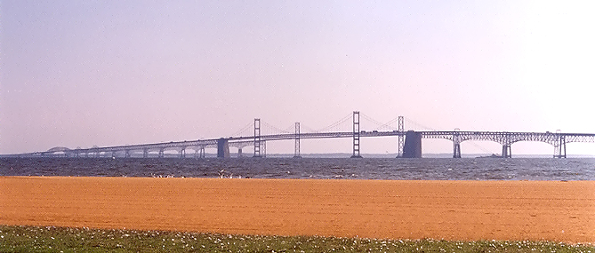 |
Chesapeake Bay Bridge, from Sandy Point State Park on the western shore of the Bay, September 28, 2006. Click image for larger photo. Very large image (317kilobytes). Photo by Scott Kozel. |
 |
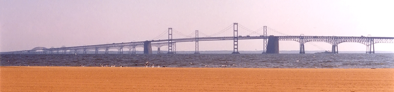
Chesapeake Bay Bridge, from Sandy Point State Park on the western shore of the Bay, September 28, 2006. Same vantage point as above photo, but with 2.7x telephoto. Click image for larger photo Very large image (684 kilobytes). Photo by Scott Kozel. |
Chesapeake Bay Bridge Photos - more Chesapeake Bay Bridge photos.
Chesapeake Bay Bridge History - detailed early history of the Chesapeake Bay Bridge, with more details about the unbuilt southern and northern crossings.
The existing Bay Bridge carries an average of nearly 65,000 vehicles per day on five lanes (the eastbound span has 2 lanes, and the westbound span has 3 lanes). It is time to think about another bridge, either on the same location, or on another location. See the Maryland Transportation Authority (MdTA) report Task Force on Traffic Capacity Across the Chesapeake Bay.
Sources: MDOT MDTA website, and cited articles. An Engineering News-Record magazine article on December 7, 1972 provides a comprehensive discussion of the parallel bridge project. Both bridges were designed by J.E. Greiner Co., Inc., of Baltimore, Maryland. The first bridge had two lanes, was opened on July 30, 1952, and cost $45 million. The second bridge had three lanes, was a "modernized look alike", and cost $148 million, and opened on June 28, 1973. See Bay Bridge History, on the Maryland Transportation Authority (MdTA) report Task Force on Traffic Capacity Across the Chesapeake Bay.
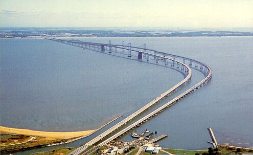
Aerial photo of Bay Bridge, from a post card from
the 1970s.
Maryland Transportation Authority link to Chesapeake Bay Bridge. Excerpt: "Often called the Bay Bridge, this facility crosses the Chesapeake Bay as part of US 50/301. The bridge's dual spans provide a direct connection between Maryland's Eastern Shore recreational and ocean regions and the metropolitan areas of Baltimore, Annapolis and Washington, D.C. The bridge also forms part of an alternative route from the Delaware Memorial Bridge to the nation's capital and has been the location of our annual Bay Bridge Walk for 27 consecutive years. With a length of 4.3 miles, the bridges are among the world's longest and most-scenic over-water structures. The original span was built in 1952 and provides a two-lane roadway for eastbound traffic. The parallel structure opened in 1973 and has three lanes for westbound travelers". Also, "The toll for two-axle vehicles is $2.50; each additional axle is $2.50". See the MdTA William Preston Lane Jr. Memorial (Bay) Bridge Fact Sheet.
About the Maryland Transportation Authority: "Since 1971, the Maryland Transportation Authority has been responsible for managing, operating and improving the State's toll facilities, as well as for financing new revenue-producing transportation projects. The Authority's seven facilities - a turnpike, two tunnels and four bridges - help keep both private and commercial traffic moving in Maryland. All of our projects and services are funded through tolls paid by customers who use our facilities".
BayBridge.com - The Maryland Transportation Authority's Web Site for Everything Bay Bridge.
Chesapeake Bay Bridge - MDSOS Kids' Page by Office of the Secretary of State of Maryland. Photos and details about the Bay Bridge.
The Maryland Transportation Authority has an extensive rehabilitation program underway on the Chesapeake Bay Bridge. Details are here on article Chesapeake Bay Bridge Rehabilitation Projects.
In 2002, the American Road & Transportation
Builders Association (ARTBA) had an article "Chesapeake
Bay Bridge, Capital Beltway & Baltimore Harbor Tunnels Selected Maryland's Top
Transportation Infrastructure Projects of 20th Century". Excerpt (blue
text):
As both a major traffic artery and
an imposing sight, Maryland's 4.3-mile Chesapeake Bay Bridge is a prominent and
important element of the state's transportation infrastructure. Carrying more
than 23 million vehicles a year, the bridge consists of two separate spans with
roadways running 186 feet above the water. The original span was built in 1952
and provides a two-lane roadway for eastbound traffic. The parallel structure
opened in 1973 and has three lanes for westbound travelers. The Bay Bridge provides
a direct connection between the tourist, recreational and agricultural regions
of Maryland's Eastern Shore and the metropolitan areas of Baltimore, Annapolis
and Washington, D.C. It also forms part of an alternative route between Delaware
- southern New Jersey and Washington. The bridge was rededicated on Nov. 9, 1967,
as the William Preston Lane, Jr., Memorial Bridge in honor of the former governor
who obtained legislative authority to build it 20 years earlier. Operated by the
Maryland Transportation Authority, the Bay Bridge is one of seven toll facilities
under its jurisdiction. Currently, the eastbound span is undergoing a $76 million
cleaning and painting project while new decking is being placed on the westbound
span at a cost of $45 million.
On the 50th anniversary of the Chesapeake Bay
Bridge, these newspaper articles were written:
"Bob
Miller's Bridge", July 28, 2002,
Baltimore
Sun. Includes 10 photos of the construction of the original bridge.
"Spanning
Half a Century", July 30, 2002,
Washington Post.
Roads to the Future articles about the Chesapeake Bay Bridge:
Chesapeake Bay Bridge Walk
Chesapeake Bay Bridge Photos
Chesapeake Bay Bridge History
Chesapeake Bay Bridge Rehabilitation Projects
Copyright © 1997-2007 by Scott Kozel. All rights reserved. Reproduction, reuse, or distribution without permission is prohibited.
By Scott M. Kozel, Roads to the Future
(Created 8-14-1997, updated 5-6-2007)