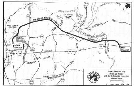
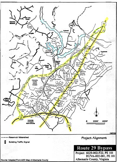
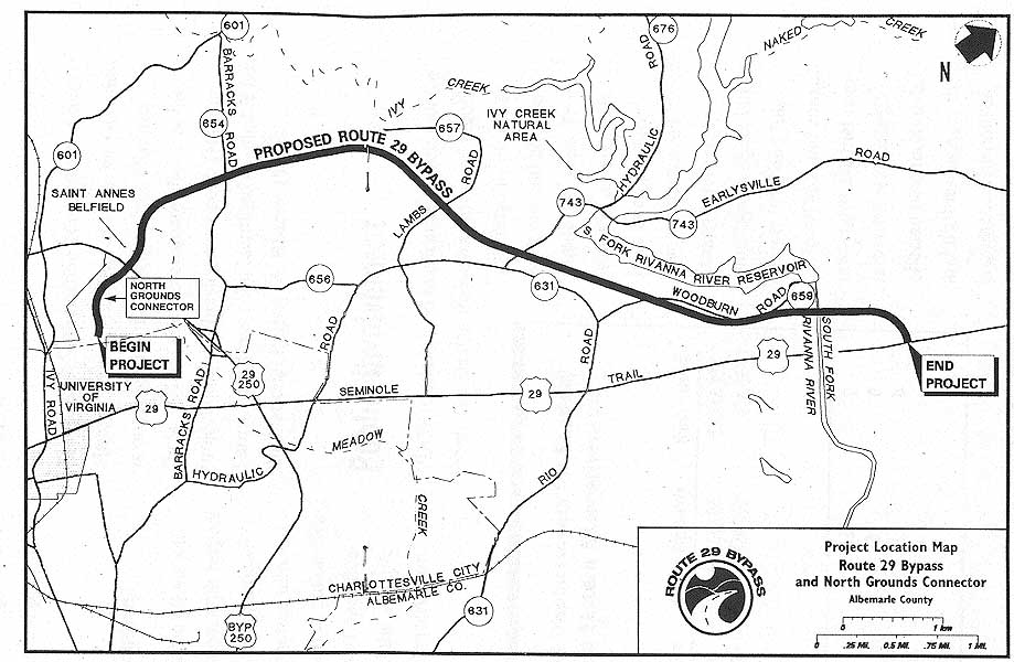
The proposed construction of a western bypass of Route 29 around the City of
Charlottesville and through Albemarle County, Virginia. The bypass, as presently
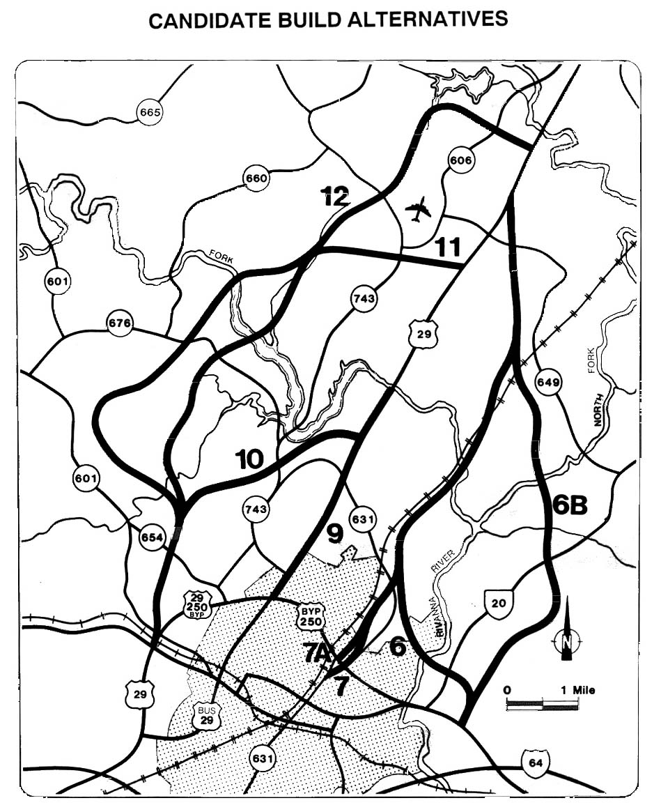
proposed, will be a four-lane, 6.2 mile highway running to the west of the current
Route 29. The southern terminus of the bypass will be placed approximately 0.7
miles north of the Route 29/250 interchange, and the northern terminus will be
approximately 0.5 miles north of the South Fork of the Rivanna River. The project
will also entail the building of a connector road into the North Grounds of the
University of Virginia, located on the south side of the existing Route 29/250
bypass. As currently contemplated, access to the bypass will be via the interchanges
at both ends, with no intermediate access points to crossroads or adjacent properties.
The bypass project, in its present form, is the product of many years of study,
planning, and debate over the best means of alleviating traffic congestion on
the Route 29 corridor through the Charlottesville area. Over the years, various
improvements have been suggested, with the principal propositions including a
widening of the existing highway, construction of an expressway along the present
highway corridor, and construction of bypasses of various configurations. In 1986,
the Federal Highway Administration ("FHWA") approved a draft Environmental Assessment
("EA") for widening Route 29. At the time of the draft EA, Route 29 consisted
of four lanes with a graded median. The widening project was to entail expansion
of the road to six lanes, in addition to continuous right-turn lanes, between
the Route 250 bypass and the South Fork of the Rivanna River. In 1991, the Virginia
Department of Transportation ("VDOT") submitted a final EA to the FHWA, and the
FHWA issued a finding of no significant impact ("FONSI") with regard to the widening
project. This widening of Route 29 came to be known as the Base Case, and will
be referred to as such in this memorandum opinion.
In 1986, Albemarle County representatives asked VDOT to evaluate the possibility
of building an expressway along the existing Route 29 corridor. Local officials
and citizens of the area recommended that VDOT hold construction of the Base Case
improvements in abeyance until the completion of a comprehensive study of the
Route 29 corridor in Albemarle County north of Charlottesville. In 1987, VDOT
selected a consultant to conduct the study, which lasted from 1987 to 1993. The
study included analyses of traffic volumes and patterns, as well as evaluations
of various alternatives, including expressway concepts.
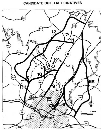
The alternatives determined to be reasonable were documented in a draft EIS
("DEIS"), which was approved by the FHWA in 1990. Among the alternatives chosen
to be discussed in the DEIS were the Base Case, the Base Case plus three grade
separated interchanges, mass transit and transportation system management strategies,
seven bypass alternatives of various alignments, and an expressway. The Base Case
served as the "no build" alternative for the DEIS. The DEIS discussed various
environmental and socioeconomic impacts presented by the different alternatives,
and it also evaluated the potential effects of the alternatives on Section 4(f)
resources such as public parks, recreation areas, wildlife refuges, and historic
sites. The DEIS was distributed to numerous state and federal agencies, and was
made available to the public.
On November 15, 1990, after considering the DEIS and public comments thereon,
the Commonwealth Transportation Board ("CTB") selected a combination of alternatives
for the Route 29 corridor. According to the CTB's resolution, the selected improvements
were to be implemented in three phases in order to address short, medium, and
long-range needs. During Phase I of the project, the CTB resolved to construct
the Base Case improvements, to reserve rights of way for the future construction
of interchanges at Rio Road, Greenbrier Drive, and Hydraulic Road, to approve
the Alternative 10 western bypass corridor for future development, and to begin
the process of securing rights of way for the bypass corridor. The CTB next resolved
that Phase II of the project would be the construction of grade-separated interchanges
at Rio Road, Greenbrier Drive, and Hydraulic Road, along with continued preservation
of the right of way for the bypass. Finally, the CTB resolved that Phase III of
the project would consist of the construction of the western bypass.
In 1992, the City of Charlottesville, the County of Albemarle, and the University
of Virginia responded to the CTB's resolution by signing an agreement (the "Three-Party
Agreement") supporting the improvements chosen by the CTB and making other suggestions,
such as building the Meadowcreek Parkway prior to the grade-separated interchanges
on Route 29. The Three-Party Agreement also requested that Charlottesville-Albemarle
Metropolitan Planning Organization ("MPO") amend the Charlottesville Area Transportation
Study ("CATS") to reflect the priorities set forth in the resolution. The MPO
amended the CATS plan on February 18, 1992 as per the request made in the Three-Party
Agreement.
On January 20, 1993, FHWA approved the final EIS for the Route 29 corridor
study, which evaluated the alternatives considered and explained the reasoning
behind the "combination of improvements" selected. The final EIS also included
a final Section 4(f)/106 evaluation. On April 8, 1993, FHWA issued a record of
decision ("ROD"), which selected a "combination of improvements to be implemented
over a number of years in three phases to serve immediate, medium range and long-term
transportation needs." To address the long-term needs, the ROD adopted the Alternative
10 bypass, as modified to eliminate the proposed interchanges at Route 654 and
Route 743. As for medium range needs, the ROD selected the construction of the
grade separated interchanges at Hydraulic Road, Rio Road, and Greenbrier Drive.
Finally, the ROD stated that immediate needs would be met by construction of the
Base Case improvements. The ROD also briefly described the Section 4(f) evaluation
process and concluded that the alternative 10 bypass was "the only feasible and
prudent alternative which avoids impacts to Section 4(f) properties."
After the Final EIS and ROD had been issued, it was proposed that the location
of the southern terminus of the bypass be shifted from the west side to the east
side of St. Anne's Belfield School and that the northern terminus be moved to
the north side of the South Fork of the Rivanna River. The FHWA determined that
an EA should be prepared to determine whether a supplemental EIS would be needed
for the modifications. VDOT then solicited comments from various local, state,
and federal entities on the proposed changes to the termini. In 1994, the FHWA
approved a draft EA, and the document was later made available to the public.
In March 1995, the CTB approved the changes to the bypass termini. Thereafter
a final EA was completed, which identified no significant environmental impacts
resulting from the modifications; therefore, FHWA issued a FONSI for the termini
changes on July 6, 1995.
In October 1994, a public information meeting was held to discuss the design
of the grade separated interchanges to be constructed as Phase II of the Route
29 project. At the meeting, many citizens, a great number of whom represented
the business community, expressed opposition to the interchanges being built at
all. In fact, of the 4,372 citizens who submitted comments during or after the
meeting, 3,270 opposed the construction of any of the interchanges, and 2,297
of those individuals recommended that the western bypass be constructed in lieu
of the interchanges. VDOT also received correspondence requesting that the interchange
phase be abandoned in favor of proceeding with the construction of the bypass.
In January 1995, the City of Charlottesville passed a resolution requesting that
the interchange at Hydraulic Road be abandoned. In addition, those in favor of
the interchanges also voiced their opinions on the subject. On February 16, 1995,
the CTB passed a resolution terminating the design and development of the interchanges
and assigning the funds allocated to the interchange study to Base Case improvements
and bypass development.
In 1995 and 1996, several changes to the design of the Alternative 10 bypass
were proposed, and VDOT and FHWA determined that these proposals made it necessary
to reevaluate the previous environmental documents prepared in connection with
the project. The process of compiling a written Reevaluation was begun in October
1996. After the commencement of the Reevaluation, several design and environmental
issues arose. For instance, in 1997, the CTB instructed VDOT to modify the design
of the interchange at the northern terminus of the bypass in order to avoid affecting
Brook Hill, an historic property that was not previously taken into account. The
CTB also ordered design changes to the connector road to the North Grounds of
the University of Virginia. In addition, further study was conducted on the noise
and archaeological impacts of an alteration to the bypass's design at Stillhouse
Mountain. FHWA also entered into a formal consultation with the U.S. Fish and
Wildlife Service ("USFWS") based on new information received concerning the James
spinymussel, an endangered species. VDOT also continued to evaluate bypass design
in light of concern over risk to the South Fork Rivanna River Reservoir. In addition,
new issues concerning the bypass project were raised in January 1998 when this
lawsuit was filed. The Reevaluation examined these changes, and concluded that
the changes and new issues resulted in no new significant impacts that would necessitate
the completion of a new or supplemental EIS. FHWA approved and signed the Reevaluation
on March 13, 2000.
In addition to the NEPA issues brought to light by the plaintiffs' lawsuit,
the complaint also pointed out Section 4(f) concerns, specifically with regard
to the Albemarle County School Complex (the "School Complex"). Subsequently, VDOT
and FHWA conducted a new Section 4(f) evaluation, treating the entire School Complex
as a Section 4(f) property. On March 13, 2000, FHWA approved the final Section
4(f) Evaluation, which concluded that there is no feasible and prudent alternative
to using a portion of the property of the School Complex. On that same day, FHWA
issued a new ROD that documented its decision to deviate from the original ROD
by selecting the Base Case improvements (which had already been completed) and
the Alternative 10 bypass.
Cities and towns along US-29 have expressed a strong interest in the development
of a bypass around Charlottesville. Two cities that have expressed especially
strong support for the bypass, are Danville and Lynchburg. Both cities believe
that a bypass is needed so that their citizens traveling to and from points north
of Charlottesville can bypass the area. In addition, they contend that a bypass
is needed so that commercial trucks traveling through the Charlottesville area
can do so unimpeded. They further assert that the bypass is needed to serve the
economic development needs in the region.
In 2002, there have been multiple newspaper articles in the Danville and Lynchburg
newspapers (Danville Register Bee,
see
"Bypass
battle flares up";
and Lynchburg News & Advance,
see
"Lawmakers push
for Charlottesville bypass"), that cited local elected
officials, local members of the General Assembly, and local business organizations,
who are openly complaining about the lack of progress on the part of the City
of Charlottesville and Albemarle County, toward building the US-29 Charlottesville
Bypass extension, to remove what they see as a major impediment toward upgrading
the US-29 corridor through Virginia. The Danville and Lynchburg areas are moving
forward and are building their US-29 bypasses, and they want to see the Charlottesville
area do likewise.
The Danville Register Bee
had an article on February 14, 2003,
Be it resolved
... Excerpts follow (blue text):
State Sen. Charles Hawkins'
resolution to push the state to improve U.S. 29 is a step in the right direction
in this long, important and tough fight. Danville and Lynchburg have long been
frustrated by the protracted fight over the U.S. 29 Charlottesville bypass. Travelers,
businessmen, economic developers and political leaders from the two cities have
long looked north hoping that some kind of bypass could be built to properly accommodate
through traffic. The Charlottesville bypass is a big, important and controversial
project … and after years of planning, and debate, the issue still hasn't been
resolved. State Sen. Charles Hawkins, R-Chatham, has been fighting for U.S. 29
improvements since his days as a state delegate. "It just doesn't seem to end,"
Hawkins said of the fight for the Charlottesville bypass.
Most importantly, Hawkins' resolution
doesn't do anything to change the hearts and minds of Charlottesville-area residents
who fight the bypass with little or no regard or concern for how that fight affects
the Dan River Region. Unfortunately for our community, too many people north of
here have closed their minds on the issue of improving U.S. 29. But ignoring that
road's development is a luxury we can't afford. We support every initiative to
upgrade U.S. 29 because as that road improves, so does its value to our economic
development efforts. It does little good to build modern bypasses around Danville
and Lynchburg only to leave a traffic bottleneck around Charlottesville.
So indeed, there are statewide issues with respect
to the need for the US-29 Charlottesville Bypass extension.
Commonwealth
Transportation Board
Excerpt from JLARC report follows in blue text:
Commonwealth Transportation Board
Another important participant in the highway location process is the Commonwealth
Transportation Board. The Board is comprised of 16 members. Fourteen are appointed
by the governor to serve four-year terms. The other two members are the Secretary
of Transportation, who serves as the chairperson, and the Commissioner of VDOT,
who serves as the vice chairperson. One member is appointed from each of the nine
VDOT construction districts. In addition, the governor may appoint five at-large
members. The CTB has the authority and responsibility to make all location decisions.
CTB Deletes Urban Interchanges and Goes Forward
with Bypass
The JLARC report documented the CTB decision to delete the 3 proposed urban
interchanges thusly (Excerpt from page 40 and 41 follows in blue text):
CTB Withdraws Its Support for the Grade-Separated Interchanges
In January of 1995, the CTB conducted a workshop at which the interchanges
were discussed. The following month, the CTB voted to withdraw support for the
design and construction of the interchanges. The CTB cited the following reasons
for withdrawing its support in the resolution:
(1) citizen comments against the interchanges at the citizen's information meeting
to discuss the design,
(2) comments made by the City of Charlottesville, University of Virginia, and
Greene County,
(3) the cost of the interchanges which were estimated to be between $12 and $15
million each,
(4) construction of the interchanges would result in the destruction of more than
60 percent of the widening recently completed on Route 29,
(5) construction of the interchanges would inconvenience motorists on Route 29
for two years, and
(6) the interchanges would only result in a minimal level of improvement in the
"ultimate level of service."
CTB Resolves to Move Ahead with the Route 29 Bypass
The CTB's February 1995 resolution supported the continuation of the other
improvements to Route 29 referenced in the 1990 and 1991 resolutions, including
construction of the Meadow Creek Parkway, and the development of the Route 29
Bypass. In addition, the resolution rescinded the conditions of the earlier resolutions
which conditioned the bypass on the establishment of a justified traffic need.
The 1995 resolution stated, "the phasing of construction for the Route 29 bypass
based on increases in traffic and economic condition [shall] be rescinded and
that the Department continue the design of the Route 29 (Alternative 10) Bypass."
The resolution also directed that funds set aside for the interchanges be redirected
to the widening and bypass projects.
JLARC Findings and Agency Responses
The JLARC report did have some findings with respect to the US-29 Charlottesville
Bypass project.
Excerpt (blue text):
Route 29 in Charlottesville Raises Some Concerns
While the highway location process appears to work relatively well in most
instances, JLARC staff's review of the location process used for improvements
to Route 29 in the Charlottesville area raises some concerns about the process
in that case. The issue of how to address traffic problems on Route 29 has been
extremely controversial. In recent years, there have been strong divisions among
various local citizen groups and between local governments in the Charlottesville
area regarding how to resolve transportation needs on Route 29. In addition, there
has been tension between local transportation interests and regional and State
interests which has further complicated the situation.
III. Case Study: U.S. Route 29 in Charlottesville
While JLARC's review of numerous highway projects found that VDOT followed
a relatively systematic location process for most projects, the review of the
location process used for improvements to Route 29 in the Charlottesville area
raises some concerns about the process in that case. The process for this project
appears to have deviated from the typical location process used by VDOT. Review
of this project also raises broader concerns about aspects of the location process
in general.
Location Process Should Apply to Actions to Rescind Prior CTB Decisions (p.
49)
One of the concerns raised by the experience of the Route 29 project is the
difference between the process used to approve location decisions and the process
to rescind previous CTB location decisions. While the CTB may only approve a location
for a new road project after an extensive process, the CTB may act to rescind
a prior location decision of the Board merely upon a vote of the CTB.
Recommendation (1). The General Assembly may wish to consider amending § 33.1-18
of the Code of Virginia to require that the Commonwealth Transportation Board
provide the opportunity for a public hearing prior to any decision to rescind
or significantly modify a previous location decision of the Commonwealth Transportation
Board.
This recommendation is in reference to the CTB canceling the 3 urban interchanges
planned for existing US-29 north of Charlottesville. See the Agency Response to
JLARC report section below for the agency response. The JLARC report gave this
reason as to why the CTB canceled the interchanges. (Excerpt follows in blue text):
Approximately 1,100 citizens attended the public information meeting for the
interchanges. In conjunction with the meeting, VDOT received 1,698 comments and
1,572 petition signatures expressing opposition to the interchanges. In addition,
VDOT received 989 comments and 790 petition signatures in support of the interchanges.
The primary reasons given for opposing the interchanges were: (1) the access problems
that would be created; and (2) the cost of construction, because VDOT would be
required to tear up a large portion of the newly completed widening work.
The second JLARC recommendation is in reference to a CTB member who might possibly
have benefited from the US-29 decision.
CTB Members Should Not Be Permitted to Participate in Location Decisions Which
Directly Impact their Personal Interests
Another concern with the current process is that members of the CTB are not
precluded from participating in decisions that impact their own personal interests,
as long they disclose their interest. Under Virginia's current conflict of interest
statute, an "officer" of the State, which would include CTB members, may participate
in a transaction in which they have a personal interest if: (1) they are the member
of a business, profession or group which is affected by the transaction; or (2)
the transaction affects the public generally. The current statute provides fairly
wide latitude for CTB members to participate in location decisions in which they
have a personal interest as long as they disclose their interest.
Recommendation (2). The General Assembly may wish to amend § 2.1 -639.11 of
the Code of Virginia to require that any member of the Commonwealth Transportation
Board who has a personal interest in a location decision or any other highway
project or contract decision before the Board recuse himself from participating
in the decision.
See the Agency Response to JLARC report section below for the agency response.
The third JLARC recommendation is in reference citizen access to the CTB regarding
a major location decision. (Excerpt follows in blue text):
More Access to CTB Should Be Provided under Certain Circumstances
Under the current location process, there is no opportunity for anyone to present
their viewpoint directly to the full CTB regarding a major location decision.
Individual CTB members may attend location public hearings for projects in the
districts that they represent, but rarely do members attend hearings outside of
the districts in which they reside. Therefore, local government officials, citizen
groups, and individual citizens do not have the opportunity to address the Commonwealth
Transportation Board on location decisions that impact them.
Recommendation (3). The Commonwealth Transportation Board should provide the
opportunity for local governing bodies to directly address the board regarding
major road projects in those cases in which: (1) there is disagreement between
the location alternative recommended by the Virginia Department of Transportation
and the alternative preferred by a locality that will be directly impacted, or
(2) more than one locality will be directly impacted by a location decision, and
there is some disagreement between the localities regarding the preferred location
alternative.
See the Agency Response to JLARC report section below for the agency response.
Agency Response to JLARC report
Excerpts from letter to Mr. Philip Leone, Director, Joint Legislative Audit
and Review Commission, from Commonwealth of Virginia, Department of Transportation,
by David R. Gehr, Commissioner (agency head), December 4, 1997. Verbatim copy
from the above referenced JLARC report (paper version), of the three JLARC recommendations
that pertain to the US-29 Charlottesville Bypass, and the VDOT responses to them
(excerpt of first 1/3 of letter follows in standard blue text, and green text
for agency response):
Thank you for the opportunity to review and comment on the exposure draft of
the report entitled Review of the Highway Location Process in Virginia. It is
apparent that a large amount of research and work went into this study. We have
completed a thorough review of the draft and present our response in two parts.
The first part, which follows, is the Virginia Department of Transportation's
(VDOT) comment and response to each of the report's recommendations. The second
part is attached as an addendum. The addendum provides pertinent information relevant
to specific sections of the draft for consideration.
Recommendation (1): The General Assembly may wish to consider amending Section
33.1-18 of the Code of Virginia to require that the Commonwealth Transportation
Board (CTB) provide an opportunity for a public hearing prior to any decision
to rescind or significantly modify a previous location decision of the Commonwealth
Transportation Board.
Response: The action to rescind prior location decisions does not often occur.
In the case of the Route 29 Bypass project, the decision was not to change or
modify the previously approved location. The decision was to modify the sequence
in which improvements were to be developed. Phasing the construction aspects of
project development is not a part of the public involvement process. The "three
party agreement", which stated support by the Charlottesville and Albemarle jurisdictions,
for the sequencing of improvements for the Route 29 Corridor was not subject to
the public involvement process. The CTB makes location and design decisions and
does not determine right of way or construction timing. Other regulations and
laws affect these construction aspects of project development.
There were several issues outside the control of the CTB which contributed
to this decision. The City of Charlottesville withdrew its support for the interchange
at Hydraulic Road, which is in the city. This decision was certainly beyond the
control of the CTB. The concern of the local businesses and citizens within the
existing corridor to access to businesses and residential areas was also a major
concern.
The Department agrees that if there is a need to rescind or change the location
that was previously approved by the CTB, then another public hearing or citizen
information meeting could be held to inform citizens of this impending action.
Any design changes or modifications, which take place within the approved corridor,
would be presented at the design public hearing held later in the process.
Recommendation (2): The General Assembly may wish to amend Section 2.1-639.11
of the Code of Virginia to require that any member of the Commonwealth Transportation
Board who has a personal interest in a location decision or any other decision
before the Board recuse himself from participating in the decision.
Response: A representative of the Attorney General's Office briefs each CTB
member on conflict of interest statutes and issues. We will ensure that these
briefings are conducted on a regular basis. The current statute allows CTB members
to participate in location and design decisions in which they have a personal
interest as long as they disclose their interest prior to making their vote. This
at times could present the perception of improper influence on the decision, especially
if there is already public concern surrounding the integrity of the process and
the Department. The recommendation as written, however, could potentially affect
every decision made by the CTB. For example, when the CTB adopts the Six-Year
Improvement program there is a possibility that every member of the CTB would
have to recuse himself or herself because of a conflict with one specific project
out of the hundreds that are included. This could also apply to votes on budget
items.
It would appear that the above recommendation should also include the Boards
of Supervisors and the MPO because they are also integral participants in the
decision.
Recommendation (3): The Commonwealth Transportation Board should provide the
opportunity for local governing bodies to directly address the board in those
cases in which (1) there is disagreement between the location alternative recommended
by the Virginia Department of Transportation and the alternative preferred by
the locality that will be directly impacted, or (2) more than one locality will
be directly impacted by the location decision, and there is some disagreement
between the localities regarding the preferred location alternative.
Response: The Department and the members of the CTB provide local governing
bodies the same opportunities it provides to the public in addressing comments
and recommendations on location decisions. The localities have opportunities at
the formal public hearings, as well as the ability to meet with their respective
CTB member, to provide input into the process. Nothing precludes the localities
from addressing any or all of the CTB members individually. Localities also have
the opportunity to provide resolutions based on their Board or Council recommendations.
Individuals or localities may address the full CTB if the following three circumstances
are met: (1) The issue they wish to discuss must be an agenda item of the CTB
meeting (2) The information must be new information, which has not previously
been available for presentation, and (3) The issue they wish to discuss has not
been through the public hearing process and there has not been an opportunity
for public comment.
It is not the recommendation of the Department that this policy be changed.
Localities have more than adequate opportunity to provide comments and recommendations,
and if new information does arise, the current policy allows the CTB to hear this
information prior to making their decision.
[end of excerpts from letter to JLARC]
Excerpts from letter to Mr. Philip Leone, Director, Joint Legislative Audit
and Review Commission, from Commonwealth of Virginia, Department of Transportation,
by Robert E. Martinez, Secretary of Transportation, December 4, 1997. Verbatim
copy from the above referenced JLARC report (paper version), of the three JLARC
recommendations that pertain to the US-29 Charlottesville Bypass, and the VDOT
responses to them (excerpt of first 1/2 of letter follows in green text):
VDOT Commissioner David Gehr has just provided me with a copy of the comments
he and his staff prepared in response to the JLARC study, "Review of the Highway
Location Process in Virginia. With this letter, I would like officially to concur
with all of the comments stated in the Commissioner's letter, including his addendum.
Kindly accept the following as reflecting some nuances in emphasis from my own
perspective.
Regarding Recommendation (1) in the report, as does Commission Gehr, I also
agree that in those instances when the Commonwealth Transportation Board (CTB)
considers rescinding or significantly modifying a previous location decision,
it should be subjected to a public hearing or public involvement process. I agree
that this would be appropriate. However, in my mind, it is very important to note
that the example used to buttress this recommendation -- the action taken by the
CTB on the grade-separated interchanges -- did not constitute a change in a location
decision. In effect, the major complaint lodged against that action was that it
contravened the so-called Three Party Agreement (Albemarle County, City of Charlottesville
and University of Virginia) which pertained to the sequencing of the three separate
projects (the widening of existing Route 29, the three grade-separated interchanges,
and the bypass). That so-called Three Party Agreement itself had not been subjected
to a public involvement process. That point must not be lost.
Separately, as correctly pointed out in the JLARC report, I do consider it
very relevant that the City of Charlottesville had, in fact, already withdrawn
its approval for the Hydraulic Road interchange prior to the action taken by the
CTB. I believe that action had an impact in the CTB's deliberations.
Regarding Recommendation (2), as a general comment, I find it unfortunate that
several people on different sides of the Charlottesville Bypass issue have been
subjected to unfair attacks on their character due to honest differences of opinion
regarding this controversial project. As regards the member of the CTB who is
the subject of JLARC scrutiny in this instance, it would have been nice had he
been afforded some means of providing input to draft language on this matter to
JLARC given that he will, undoubtedly, be subjected to intense media questioning
immediately upon release of a report he has not seen. JLARC may wish to consider
how such individuals might be provided with some appropriate advance notice in
future studies.
Regarding Recommendation (3), I again concur completely with Commissioner Gehr.
As Chairman of the CTB, I add that unless written extremely narrowly any opening
up of the existing guidelines would explode the CTB's ability to move the highway
and transit program overall given the huge number of approvals required monthly.
Also, remember that the entire CTB sits through eleven full public hearings per
year during the allocation season. At that time, all members of the public can
address the Board directly, and hundreds avail themselves of this opportunity
annually.
You may wish to point out in the opening of the report, that the Chairman and
Vice Chairman do not vote at the CTB except in instances of a tie vote. If there
is a tie, the Chairman casts the deciding vote. I believe this has happened only
once during my four-year tenure. If there is a tie, the Chairman is absent and
the Vice Chair is the acting Chair, then he casts the deciding vote.
I'm not certain where the comment is most appropriate, but it should be clear
that the decisions on the Charlottesville Bypass have not resulted from any lack
of public participation or involvement, from any lack of opportunities for participation
or involvement, or from insufficient deliberation -- very careful deliberation
-- by members of the CTB. Unfortunately, the resulting decision is not universally
accepted, but it was not due to those factors.
Although mentioned in passing, on the issue of the Charlottesville Bypass,
I don't believe the Report adequately addresses the issues related to concerns
outside the immediate Charlottesville-Albemarle region regarding the state-wide
significance of the project. In particular, JLARC should have visited and more
carefully documented comments from community leaders in Lynchburg and Danville.
Another clarification is necessary in the Report in the section beginning on
page 68, "Project Remains Controversial." The local MPO did not "remove the bypass
project from their Transportation Improvement Program (TIP)" as there stated.
The MPO has failed this year to include the Bypass for construction. Nonetheless,
the Bypass remains in the TIP, as it has in prior years, for preliminary engineering
and right-of-way acquisition. Significantly, VDOT is not currently in the construction
phase, but only at right-of-way acquisition.
[end of excerpts from letter to JLARC]
US-29 Interstate Highway
There has been considerable discussion for some years about building an Interstate
highway in the US-29 corridor, from I-40/I-85 at Greensboro, North Carolina, all
the way to where US-29 connects to I-66 at Gainesville, Virginia. I would say
that the likelyhood is good that this will eventually happen. There are active
plans now for extended limited access bypasses for US-29 in the Lynchburg area
and in the Charlottesville area, and the 20-mile-long US-29 Lynchburg-Madison
Heights Bypass is well under construction, and the final phase of the US-29 Danville
Bypass (parallel roadway on the northeast quadrant) is now under construction.
There were a number of newspaper articles about the US-29 Interstate, from
about 1985 until the early 1990s, and it seems as if it has been pretty much out
of the news since the expensive I-81 widening has been in planning stages since
the mid 1990s.
If US-29 from I-40 at Greensboro to I-66 at Gainesville doesn't become an Interstate
soon, at least it will see various major improvements including new bypasses,
more interchanges at major junctions, more sections with paved shoulders, more
long right-turn lanes and left-turn lanes, and some selected alignment improvements.
In other words, lots of improvements can be accomplished that will expand capacity
and enhance safety and ease of travel for the motorist, at a much lower cost than
building a new Interstate. The new location bypasses could be utilized for a future
Interstate, also. The section of US-29 from I-40 at Greensboro to I-66 at Gainesville,
is a Principal Arterial on the National Highway System, which just a little bit lower in importance (and FHWA funding priority and qualification)
than rural Interstate.
From the The National Transportation Library,
U.S. DOT, Intermodal Surface Transportation
Efficiency Act of 1991, High Priority Corridors on National Highway System,
excerpt (blue text):
(17) Route 29 Corridor from Greensboro, North
Carolina, to the District of Columbia.
Truck Toll Lane Proposal for I-81 and Impact on US-29
One of my pet project ideas has been for private investors to finance the planned
expensive widening of I-81 in Virginia with private investment financing, with
tolls to recoup the investment. In January 2002, under PPTA (Virginia's Public-Private
Transportation Act of 1995), a consortium filed an unsolicited project proposal
to build this project, with VDOT. The billions of dollars in costs would be financed
through bonds and retired through tolls assessed electronically on large trucks,
and the project wouldn't utilize state or federal tax funds. The PPTA Evaluation
Panel is examining this proposal.
See my article "
Interstate
81 and Interstate 77" for more information
about the truck toll lane proposal for I-81, with cites from the newspapers
Winchester Star and Roanoke Times. Most of my discussion
and evaluation of the I-81 truck toll lane proposal is on that article.
In my opinion, the truckers will grumble some if the truck toll lanes are built
on I-81, but with the enormously better traffic service, comfort and speed on
I-81, very few (if any) truckers will take alternate non-Interstate routes. Time
for a trucker is money, and the $30 to $40 toll that has been discussed for the
325 miles of I-81 truck lanes, will be seen as a minor cost compared to the benefits
of I-81 and the costs of lost time and lower fuel mileage on alternate routes.
A few speakers at the US-29 public hearing in 2002, expressed fears that the
I-81 truck toll lane project might divert traffic to the US-29 corridor, and that
improving US-29 at Charlottesville might facilitate even more of such a diversion.
My "surmise" at this point (pending official traffic and origin/ destination
studies) is that the I-81 truck toll lane concept wouldn't impact the US-29 corridor
in a significant way. Interstate I-81 (in conjunction with I-40, I-66, I-70, I-76,
I-78, I-84, and I-88) provides an ideal Interstate bypass corridor for traffic
between the Northeast major metropolitan areas, and the western Deep South states
and the southwest states. Use of US-29 to bypass I-81 in Virginia, involves more
distance if you return back to I-81, and about the same distance if you are willing
to enter/leave the Northeast Corridor at D.C. rather than bypass the Northeast
metro areas that you are not going to or leaving. US-29 is slower than a rural
Interstate, with various traffic lights and speed zones on US-29. If the truck
roadways are fully separated from the car roadways, the trucks will have a congestion-free
superhighway to themselves for 325 miles through Virginia, and may even get a
higher speed limit than Virginia's 65 mph speed limit on rural Interstates.
Also, considering the high cost of the planned US-29 Charlottesville Bypass,
$180 million total for engineering, right-of-way and construction, perhaps a private
consortium will decide to tender a PPTA proposal to build this with all or nearly
all private funding, to be recouped by tolls. A $1.00 car toll and a $3.00 large
truck toll, would probably be sufficient to support the private toll revenue bonds,
with the 15,000 or more vehicles per day and 10% large truck percentage that is
projected initially on the new US-29 bypass. Having tolls on both I-81 and the
new US-29 Charlottesville Bypass, might help ensure that a traffic shift doesn't
occur if only I-81 is tolled. Also, given how VDOT is strapped for highway construction
funding, I think that it would be great if the private sector would step in and
fund these projects. Perhaps the private sector will eventually be able to raise
capital on the stock markets, for equity toll road financing. A public information
campaign would let the public know that their tolls are being used to fund a privately
funded highway that might not exist otherwise, with the tolls going to the private
enterprise so that they can recoup their investment, so such a public information
campaign could help alleviate the complaints that some people have about paying
a highway toll. Also, modern toll plazas such as the one at the new Route 895
Pocahontas Parkway near Richmond, Virginia, have superhighway roadways for non-stop
full-highway-speed electronic toll collection with Smart Tag (and EZ-Pass also
in the future), and outer toll plaza roadways for cash toll collection.
The Route 29 Bypass: A Rational View
By Mr. H. Carter Myers, III, Culpeper District representative on the Commonwealth
Transportation Board (he retired from the CTB in April 2002, after serving 8 years).
Published in the Charlottesville newspaper The Daily Progress. Provided
to me by a member of the North Charlottesville Business Council, who told me that
this is not copyrighted material and that Mr. Myers desires for it to be distributed
freely. Verbatim copy follows (blue text):
The Route 29 By-pass: A Rational View
The History
Rt.29 is a strategic north-south transportation corridor from North Carolina
to Gainesville. It is also a critical artery serving local commuters, shoppers,
airport traffic and our fastest growing areas. Traffic volume in certain sections
reaches 60,000 vehicles per day.
For nearly 25 years, our community has painfully searched to find a balance
between the statewide and regional needs of a Rt. 29 "throughway" and the impacts
on the local land, the environment, property values and our quality of life.
After studying approximately 27 possible road locations in the City and County,
it was determined that the one with the least impacts, most direct path, and least
cost was Alternative 10, ("Rt. 29 Western By-pass").
While this location has been criticized for many reasons, there were good reasons
why this route was selected.
Selecting the Alternatives
First, all eastern routes and routes through the City were ruled out because
of impacts to Monticello, costs, special easement conflicts, or substantial impacts
to developed property.
Second, the far western routes, while more in the form of a "true by-pass,"
all crossed appreciably more of the Rivanna watershed and crossed the Reservoir,
impacted more rural land, farms and subdivisions, cost more, and faced greater
public opposition.
Third, the "Expressway" concept of a depressed four-lane road built down the
middle of the current Rt. 29 North, with service roads for local traffic, was
eliminated because of the significant cost, traffic confusion and impacts of building
through this densely developed commercial section.
The Western By-pass, the shortest and least expensive, was selected and approved
by the Commonwealth Transportation Board (CTB) in 1990 following a location public
hearing and the issuance of an approved Federal Highway Administration (FWHA)
Environmental Impact Statement.
The Advantages of the Selected Route
It was selected on the basis of the following:
I. This route does not cross the reservoir and has the shortest path (only
3.4 miles) in the watershed.
2. This was the least costly of the alternatives. While still costly, other
than the delay, extra reservoir protection, and other community accommodation,
there is nothing unusual that adds to cost other than bridges and rolling land.
3. Because of its close proximity, this route gives the most local benefit
and diverts the most local traffic from the existing Rt. 29 North. If built today,
approximately 15,000 vehicles would be diverted from the existing Rt. 29 North
(approximately 25% of the current traffic). Travel would be uninterrupted from
the Rt. 29-250 By-pass to Route 29 north of the Rivanna River.
4. It will serve traffic going to the University for employee parking, game
traffic and the proposed new basketball arena. Improving mobility in the City
at the Hydraulic Rd. intersection, the Rt. 250 / 29 By-pass ramp, along Emmett
St, and on Ivy Road will be a substantial benefit.
5. Being the shortest route with no interchanges, it will have little impact
on growth and development. While VDOT questioned the decision not to put an interchange
at Hydraulic Rd., Albemarle County's request was honored.
6. Schools are not being affected. For purposes of comparison, St. Anne's Belfield
Lower School is closer to the current Rt. 29-250 By-pass than any school would
be to the Western Bypass. In fact, Agnor-Hurt Elementary, the County school nearest
the Bypass route, was built by Albemarle County after the location was chosen.
7. The safety of the traveling public will be improved. Accident records historically
show that a highway interrupted with traffic signals and unlimited access results
in a greater number of accidents and deaths.
Twenty Five Years of Debate is Long Enough
Some have suggested we stop the By-pass. Unfortunately, we can't stop the need
for a limited access route around Rt. 29. Even if we abandon the current project,
we would need to begin a new search for a new route immediately. This would put
new areas of the City and County back on the option table, and create a cloud
over all property in the area. It would be a terrible situation to again put our
citizens through.
There have been several debated alternatives. One contemplated building three
grade-separated interchanges on Rt. 29 North at the intersections of Hydraulic
Rd., Greenbrier Dr. and Rio Rd. In the mid '90s, VDOT spent $750,000 studying
these interchanges. The plans, impacts, costs and benefits of these interchange
projects were taken to a public information meeting and a meeting with the City
and County officials. The City rejected the idea of an interchange at Hydraulic
and withdrew its support.
While there would be a slight benefit for "through" traffic by the elimination
of the three signalized intersections on the current Rt. 29 North, there would
still be at least seven signal lights along with confusing and busy interchange
ramps.
In 1995 the CTB voted to terminate the grade separation project. It used the
remaining funds to build sidewalks and landscape the current Rt. 29 and moved
the balance of the funding to the Western By-pass.
Proposals to move the north/south "through traffic" to an upgraded Rt.15 at
Zion's Crossroads in lieu of building the Western By-pass have not proven feasible.
Diverting north/south traffic sixteen miles to the east on I-64 and getting approval
for road widening through the Greensprings Historical District of Louisa are not
viable options.
The truth is, we are way down the road toward completing this project. For
example:
è
All design work and related costs except for the northern terminus have been funded
and completed.
è
Substantially all the property required to build the road has been purchased except
for the northern and southern ends. All homes and the old SPCA have been acquired.
è
All environmental impacts have been assessed and the FWHA has approved the Final
Environmental Impact Statement.
Time to Move On
In closing, while no route is perfect, the current location of the Western
By-pass will have positive benefits to our community and to the citizens traveling
through Central Virginia. In fact, a 1995 survey of 625 local residents indicated
support for the project by almost three to one.
From an environmental perspective, our reservoir will have more protection
than any other in Virginia (I-64 crosses directly over the Newport News reservoir).
All environmental impacts have been studied and will be appropriately mitigated.
Extensive and thorough reservoir protection has been built into the design features.
Spill protection, retention ponds, retaining walls, storm water and silt detention
and filtration are all designed into the project.
From an economic perspective, it is important to note that our neighbors are
moving ahead. Danville now has its by-pass. The Lynchburg-Madison Heights By-pass
is under construction. All cities and towns from North Carolina to I-66 will soon
have a Rt. 29 By-pass with the exception of Charlottesville.
Finally, from a historical perspective, it is interesting to note that the
same type of debate took place 50 years ago when the functional and attractive
Rt. 250 By-pass was proposed and built. No road could be nicer looking and more
beneficial to this community.
It is time to bring this twenty-five year debate to a close, bring our community
back together and move on to look at other transportation needs of our community.
What is "Sprawl"?
Here is a letter which I wrote to the editor of the
Richmond
Times-Dispatch about this issue:
I've been a Richmond Times-Dispatch subscriber for many years,
and one who is generally satisfied with the newspaper. You may publish the following
Letter to the Editor if you wish.
I have read Mr. Rex Springston's article "Experts say sprawl still spreading
- Efforts to control it locally faulted", from Nov 18, 2001. This article is generally
similar to the whole "sprawl" series that he has written over the last year.
The definition of "sprawl" quoted in the article, is NOT a widespread definition
of "sprawl".
The reason why I put the word "sprawl" in quotes is because I consider it to
be the urban planners N-word, an offensive pejorative used to slam development
patterns that the urban planners don't like. People like the Richmond city official
and the VCU urban planning department chair (who Mr. Springston quotes Nov. 18th
and in the past) seem to like the word, as do groups like the Sierra Club and
their ilk.
I see that Mr. Springston uses language like "sprawl quickly eats up farmland
and forests" and "the Richmond area is the sprawl champ of Virginia" and a couple
dozen other such hyperbolic phrases that I have seen throughout his series of
"sprawl" articles. I consider this to be demagogic language, and I don't see any
quoted rebuttals in his articles from the critics of the "anti-sprawl movement".
By the way, from years of following the land-use management issue as it applies
to development patterns, I believe that the bulk of the "anti-sprawl movement"
is made of two groups of people, 1) those who live in low-density exurban areas
who want to keep the "sprawl" from reaching them and increasing the density of
their areas, and 2) those who live in and/or have businesses in high-density cities,
who feel threatened by the suburban expansion allegedly diminishing the influence
of their city. I consider both groups of people to be operating from ulterior
motives, who use the pejorative word "sprawl" and their contrived definition of
it as a bogeyman to attempt to influence public and official opinion in their
favor.
Here are some of the well-known critics of the "anti-sprawl movement". I think
that their material should be included as rebuttal material in any serious newspaper
discussion series about so-called "sprawl". Wendell Cox Consultancy and the Public
Purpose (
http://www.publicpurpose.com),
The Thoreau Institute (http://www.ti.org),
and Reason Public Policy Institute (http://www.rppi.org).
[end of letter to editor]
Here is another letter which I sent to the Richmond Times-Dispatch.
I decided to respond to it with a letter to the reporter. I think that such a
letter to a reporter about his newspaper article, is fair game to post on my website.
This one mainly concerns refutation to some of the disinformation produced by
the Sierra Klub, Virginia Chapter.
Mr. Jones,
I've been a _Richmond Times-Dispatch_ subscriber for many years, and one who
is generally satisfied with the newspaper.
I must take exception to the Sierra Club's conclusions cited in your November
18, 2001 article, "Richmond fails test on clean air - Study: Too little money
goes toward mass transit".
Excerpts follow with my comments:
'The report highlights the need for the Richmond area to give residents more
opportunities to get out of their cars, said Glen Besa, director of the Virginia
chapter of the Sierra Club.'
SMK: What do they suggest? While the Richmond Metropolitan Planning Organization
2023 Constrained Long Range Plan (CLRP) suggests possible local commuter rail
lines sometime beyond 2015, there is no need for local rail transit before then.
The local GRTC bus system has 55 local lines and 12 express lines, and the good
regional highway system can certainly support more local and express bus service.
The Richmond area has 1 million population and does fine with the bus public transit
it has now. Long distance passenger rail is presently being enhanced with the
renovation of Main Street Station in the downtown, to be reopened to passenger
service next year; and the Richmond-Washington high-speed rail project has already
begun.
'Virginia dedicated $5.10 to public transportation for every $100 to road construction,
according to the Sierra Club report. By contrast, New York received an A for spending
$128 on transit for every $100 on roads.'
SMK: I've seen this bit of disinformation from the Virginia chapter of the
Sierra Club, several times in the past. It needs to be refuted.
The first comparison is VDOT funds allocated to local public transit systems
in the state, and VDOT spending on roads -- it is a bogus comparison since it
compares VDOT spending on the over 85% of the public road mileage in the state
that is VDOT administered, to the VDOT allocations to the 30 mostly-locally administered
and funded urban transit systems around the state. It ignores the state funding
to public transit systems that is provided by the Virginia Department of Rail
and Public Transportation, and it ignores the expenditures by the Washington Metropolitan
Area Transit Authority (WMATA) to Metrorail and Metrobus operations in Northern
Virginia, and it ignores the expenditures by the Virginia Railway Express (VRE)
to local commuter rail operations in Northern Virginia.
So the real figure is probably over 10% as much total public funding in Virginia
for transit, compared to total public funding for roads; for all levels of government.
Given that transit in Virginia has less than 3% of the ridership as compared to
the ridership on cars on roads, and that transit carries no freight, I think that
public transit is already getting far more public funding than its modal share
would indicate.
As far as the "New York" comparison, the Sierra Club conveniently omits whether
they are referring to "New York City" or to "New York State". That figure looks
right for the City, but not for the whole state. I don't trust the Sierra Club,
since they constantly demagogue the issues when it comes to transportation issues.
Right there they put Virginia alongside of New York without specifying whether
they were referring to New York City or to New York State, and from my reading
of some of the Sierra Klub's literature over the years, I think that the Virginia
chapter of the Sierra Club is deceptive enough to use the figure for New York
CITY, leave off the word "city" and compare it to Virginia (which is obviously
a state), so that the reader will assume that the Klub meant New York STATE.
'"For the last 50 years, we've been putting virtually all of our money into
roads," Besa said. "While it's given us a lot of freedoms and benefits, it's given
a lot of air that's not safe to breathe in the summer."'
That's baloney any way you slice it.
Urban air quality in the Richmond area, in Virginia, and all over the U.S.,
has steadily gotten better over the last 30 years, and is vastly improved over
that period.
The Virginia state and local governments have done a decent job over the last
40 years of investing in public transit where it is needed. Washington Metrorail
cost $11 billion to build, and has a $1.5 billion annual budget for operations
and construction; and 1/3 of the Metrorail system is in Northern Virginia.
The cost to build the 103 miles of Metrorail, $11 billion, is almost three
times the cost to build the 1,124 miles of Interstate highways in Virginia, $4.5
billion. So much for Besa's bogus whining about "putting virtually all of our
money into roads".
[end of letter to reporter]
Sources
1) "Route 29 Corridor Study, City of Charlottesville and Albemarle County";
Location Public Hearing brochure, from the Location Public Hearing, held on June
28, 1990, by VDOT.
2) "Route 29 Interchange Design: Hydraulic Road, Greenbrier Drive, Rio Road; Albemarle
County, City of Charlottesville"; Public Information Meeting brochure, from the
Public Information Meeting, held on October 26, 1994.
3) "Route 29 Bypass Modifications: Northern and Southern Termini, City of Charlottesville
and Albemarle County"; Location Public Hearing brochure, from the Location Public
Hearing, held on February 13, 1995, by VDOT.
4) "Bypass Update: Information About the Route 29 Bypass Design"; Winter 1997,
by VDOT.
5) "Route 29 Bypass: Albemarle County"; Design Public Hearing brochure, from the
Design Public Hearing, held on February 25, 1997, by VDOT.
6)
Highway Location Process Report Summary,
and
Review of the Highway Location Process,
by Joint
Legislative Audit and Review Commission (JLARC) of the Virginia General Assembly,
January 1998.
7)
Piedmont Environmental Council v. United States
Department of Transportation, Case Number:
3:98CV0004, Issued: 08/21/2001, by Judge Norman K. Moon,
United
States District Court for the Western District of Virginia.
8)
012286.U ... 02/07/03 Piedmont Environ v. US Dept of Transport, Case Number
012286.U, issued February 7, 2003, by
United States Court of Appeals for the Fourth Circuit.
9)
Road Officials Brief County Board on Rt. 29 Environmental
Study, February 6, 2002, news release,
by VDOT.
10) "Route 29 Bypass: Draft Supplemental Environmental Impact Statement, Albemarle
County and the City of Charlottesville", handout sheet from the Public Hearing,
held on March 14, 2002, by VDOT.
11) VDOT/CTB Six-Year Program, Fiscal Year 2002-2007.
Legend
VDOT - Virginia Department of Transportation
FHWA - Federal Highway Administration
CTB - Commonwealth Transportation Board
MPO - Metropolitan Planning Organization
CAMPO - Charlottesville Area Metropolitan Planning Organization.
TIP - Transportation Improvement Program
EA - Environmental Assessment
FONSI - Finding of No Significant Impact
EIS - Environmental Impact Statement
FEIS - Final Environmental Impact Statement
DEIS - Draft Environmental Impact Statement
SEIS - Supplemental Environmental Impact Statement
ROD - Record of Decision
NEPA - National Environmental Policy Act
SC - Sierra Club
PEC - Piedmont Environmental Council
RE/T group - radical environmentalist/transit group
Credits
Copyright © 2002-2004 by Scott Kozel.
All rights reserved. Reproduction, reuse, or distribution without permission is
prohibited.
Back to top
By Scott M. Kozel, Roads to the Future
(Created 5-1-2002, updated 2-15-2004)
