
| Baltimore Early Expressway Planning |
Baltimore Early Expressway Planning
Urban expressway planning began in the City of Baltimore in 1942, and 12 different plans were eventually studied.
The table of contents below has internal links on this page to sections of
this article. You can mouse click the link to go to that section, and hit the
"Back" key on your browser to return to the table of contents.
An article about early expressway planning in Baltimore, "Baltimore's Highway Wars Revisited", by Michael P. McCarthy, Baltimore, Maryland, was recently published in Maryland Historical Magazine, Volume 93,2 (Summer 1998), Maryland Historical Society, 201 West Monument Street, Baltimore, Maryland 21201.
The Baltimore region currently and in the past typically used the word 'expressway' to describe these highways. The usage of 'expressway' in their reports, in the local newspaper articles reporting on the system's progress, and in my article here, means a divided highway with 4 or more lanes, with full control of access, and full grade separation and access only at interchanges. The proper technical term that is used by engineers and other transportation professionals is the term "freeway", whose root was derived from meaning "freedom from at-grade crossings and freedom from adjacent property driveway access"; it doesn't derive from whether or not tolls are charged on the highway. Since 'expressway' is used locally and in the local historical media references in most instances, I most commonly will refer to these highways as 'expressways' in this article.
Michael McCarthy's article covers expressway planning and development in the city of Baltimore, from 1942 to the early 1970s. Much of what he discusses concerns the proposals for the East-West Expressway. He doesn't get into discussions of the 10-D Interstate System approved in 1962, or the 3-A Interstate System that was approved in 1969; these are discussed fully in my "Baltimore City Interstates" website article. He discusses the community opposition that caused modification of these early proposals, and the eventual cancellation of some segments. McCarthy provides a balanced viewpoint, on one hand pointing out the disruption that the East-West Expressway would have caused had it been built, on the other hand pointing out the insufficient road access today to the central business district and the neighborhoods that it would have directly served. So his article is neither 'anti-highway' nor 'pro-highway', it provides a balanced historical overview of the highway.
Baltimore's Department of Planning (BDoP) produced the document A Study for an East-West Expressway, and released it in January 1960. Three local engineering firms were hired to review the study and consider any alternative possibilities. This group was a consortium known as Expressway Consultants, and they made significant changes to the BDoP route, and released their report in October 1961. BDoP and the regional planning commission were generally displeased with the changes, and other civic groups and public agencies were also unhappy. There were more revisions, more controversy, and McCarthy suggests that this laid the foundation for the eventual defeat of the East-West Expressway. He also cites the fact that apparently the Department of Planning and the regional planning commission did not have the powers that they supposedly were imbued with.
Expressway Consultants was actually a separate firm, comprised of engineers and planners from these 3 local civil engineering consultants -- J.E. Greiner Company (worked on Baltimore Harbor Tunnel, Chesapeake Bay Bridge, and turnpikes in Pennsylvania, New Jersey, Indiana and Ohio); Remmel, Klepper & Kahl (extensive final design on Baltimore Beltway and Illinois Toll Road, plus many other projects in the Baltimore-Washington area); and Knoerle, Graef, Bender & Associates (design work on many U.S. turnpikes plus the Jones Falls Expressway).
Crosstown expressway proposals began in 1942, and there were nine different proposals before the 1960 proposal. All these plans were rejected; one major reason was concerns that there was not enough through traffic on US-40 to warrant another expressway (besides the planned Harbor Tunnel Thruway which would open in 1957), the other major reason was the fact that all the proposed alignments had a northerly routing which passed the north edge of the central business district (CBD) and through a major neighborhood along North Charles Street.
A direct quote from the MHS article (blue text):
Baltimore's victory over the federal expressway planners has been considered one of its finest hours. Saved from the wrecker's ball were houses and other buildings in historic Fells Point and Federal Hill, plus blocks of other rowhouses in east and west Baltimore. Equally important, downtown was also spared all the ramps and the cloverleafs that would have taken precious land from the Inner Harbor. But from the perspective of the 1990s, were those victories really beneficial? Many of those neighborhoods on the east and west sides that were saved from the expressway have fallen victim to other ills like high unemployment, crime and drugs. Ironically, the lack of expressways in those neighborhoods has also made it difficult for 'empowerment zone' programs to attract private capital because they lack good connections to the Interstate system. And today downtown could certainly use the east-west expressway that was proposed, to get the clogging crosstown traffic off Pratt and Lombard Streets.10-D and 3-A Interstate Systems
Interestingly, McCarthy doesn't mention the 3-A Interstate System in his article. He assumes that the East-West Expressway cancellation might have been a loss to the city, while not mentioning the later expressway system concept in any detail. He does mention the Urban Design Concept Team that was formed in 1966, who shared planning activities with Expressway Consultants. The new group was intended to assist Expressway Consultants, and it included architects from Skidmore Owings & Merrill, social scientists, and two technical consulting firms - Parsons, Brinckerhoff, Quade & Douglas, and Wilber Smith & Associates. The article doesn't mention it, but this is the team that developed the Baltimore 3-A Interstate and Boulevard System which was approved in 1969, which in my opinion (and that of many others) provided a much better urban expressway system solution for the city of Baltimore, than did the 10-D system.
My article "Baltimore City Interstates" has details about the 10-D Interstate System; it is the concept presented by Expressway Consultants, and the road maps of that era showed it with the proposed routes. That article also covers the 3-A Interstate System.
My article "Baltimore 10-D Interstate System Map" has a scanned map of the 10-D System.
My article "Baltimore History of Expressway Planning - 1970" has a good historical overview from 1942-1970.
The 3-A Interstate System differed from the 1962 10-D Interstate System and earlier proposals, in that it was designed to bypass, and not penetrate the central business district (CBD) as the 10-D System would have. I-95 with 8 lanes was shifted to the Locust Point Peninsula with a harbor crossing near Fort McHenry to East Baltimore, and I-70 with 8 lanes was shifted to a junction with I-95 in southwest Baltimore, and the CBD would be served by 4 Interstate spurs reaching its edge, rather than having the main expressways pass through the edge of the CBD. I-83 with 6 lanes would still pass through the east edge of the CBD, but it would head east to a junction with I-95 in East Baltimore; in effect, I-83 would not handle through traffic, but it would serve as a northerly spur to/from the downtown, and as an easterly spur to/from the downtown. At first, I-83 was planned to pass through the Fells Point neighborhood on a 6-lane elevated viaduct, but that plan was changed in the mid 1970s so that I-83 would have passed through a 6-lane underwater harbor tunnel just south of Fells Point, so that the Interstate would avoid the Fells Point neighborhood. I-70 with 8 lanes would pass through West Baltimore, and the 6-lane I-170 spur would provide a westerly spur to/from the downtown. I-395 with 6 lanes would form a southerly spur for I-95 south traffic to/from the downtown. City Boulevard (today's MLK Jr. Blvd.) would be a 6-lane collector-distributor bypass (a partially-controlled access urban boulevard) along the western edge of the CBD, and it would serve as a distribution interface between the downtown streets and the termini of the I-170 and I-395 spurs, plus as a connector between the two spurs, plus as a western bypass of the CBD.
The 3-A System proposal was much less intrusive to the city than the 10-D System, and it still provided full access to the downtown, also providing access to and linking together previously isolated sections of the port.
The federal government included the East-West Expressway in the Interstate Highway System in 1956. Baltimore Mayor Thomas D'Alesandro Jr. asked the Department of Planning to review the earlier proposals, and consider other alternatives. The BDoP study released in 1960 was a major departure from the past studies. Rather than the expressway pass the north edge of the CBD, it would pass along the north side of the Inner Harbor, e.g. the south edge of the CBD. This proposal would provide better access to downtown Baltimore, and it would also provide better access to the industrial areas in the Fells Point and Canton areas of the port. This proposal also downplayed the interstate traffic function of the expressway, because Maryland State Roads Commission studies showed that only 4-6% of the expressway traffic would be interstate in nature, mainly because the new Harbor Tunnel Thruway (today's I-895) was already diverting through traffic from US-1 and US-40, to the crossing in the southeast part of the city, through the Brooklyn and Canton districts. The new East-West Expressway proposal would primarily serve the city of Baltimore.
The article showed a copy of a map published in the Baltimore Sun, January 31, 1960. It showed the new Department of Planning (BDoP) southerly routing, as well as the original northerly routing. The proposed highway entered the city's western edge about 1/2-mile north of Edmondson Avenue, immediately entering Leakin Park, passing through that park, then entering Gwynns Falls Park, curving southeastward toward Edmondson Avenue, then passing through the Franklin Street - Mulberry Street corridor. When it passed Fremont Avenue near the west edge of the CBD, it curved sharply south down to Pratt Street, and then sharply east again, passing along the north edge of the Inner Harbor on an elevated viaduct. There was a large interchange with I-83 at the southeast edge of the CBD, and the expressway continued eastward through Fells Point, then down the Boston Street corridor, finally junctioning the Harbor Tunnel Thruway (HTT) near Boston Street. The expressway west of I-83 would be I-70N, east of I-83 it would be I-95. The Southwest Expressway was shown as a portion of I-95 that would pass by Federal Hill, cross the Inner Harbor on a fixed bridge with 50 feet of vertical navigational clearance, and junction the East-West Expressway, continuing northward as the Jones Falls Expressway (I-83).
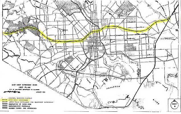
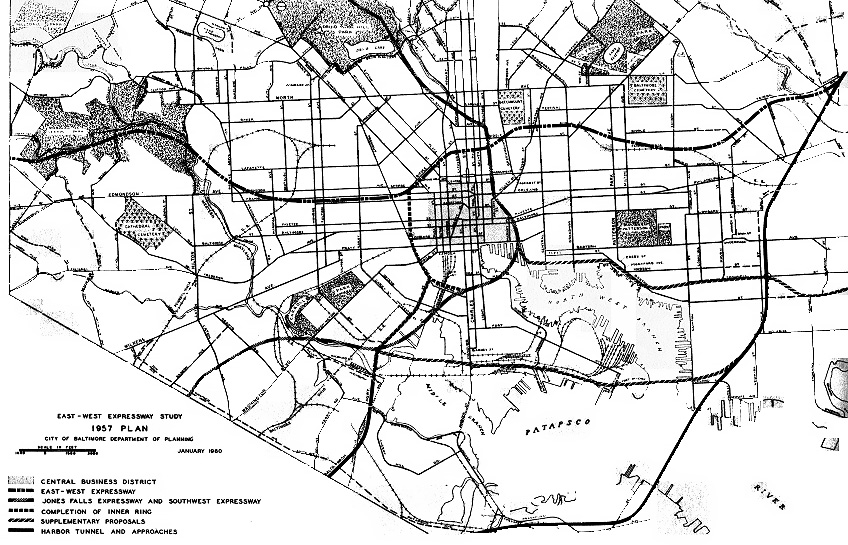
The following map reflects the state of expressway planning in the City of Baltimore, the system as approved in 1957 by the City of Baltimore, Planning Commission.
 |
"East-West Expressway"
(highlighted by me in yellow) and "Jones Falls Expressway and Southwest Expressway"
proposals are shown. In this study and in all previous studies, the East-West
Expressway followed the Northern Route where it passed just north of the central
business district. "Completion of Inner Ring" and "Supplementary Proposals" are future proposals. "Harbor Tunnel and Approaches" was opened to traffic in 1957. Click for larger map images: Medium (168K), Large (270K), Extra Large (443K). The best detail is on the largest image. |
| 1957 Plan, from A Study for an East-West Expressway, Sheet 6, by the City of Baltimore, Department of Planning, January 1960. |
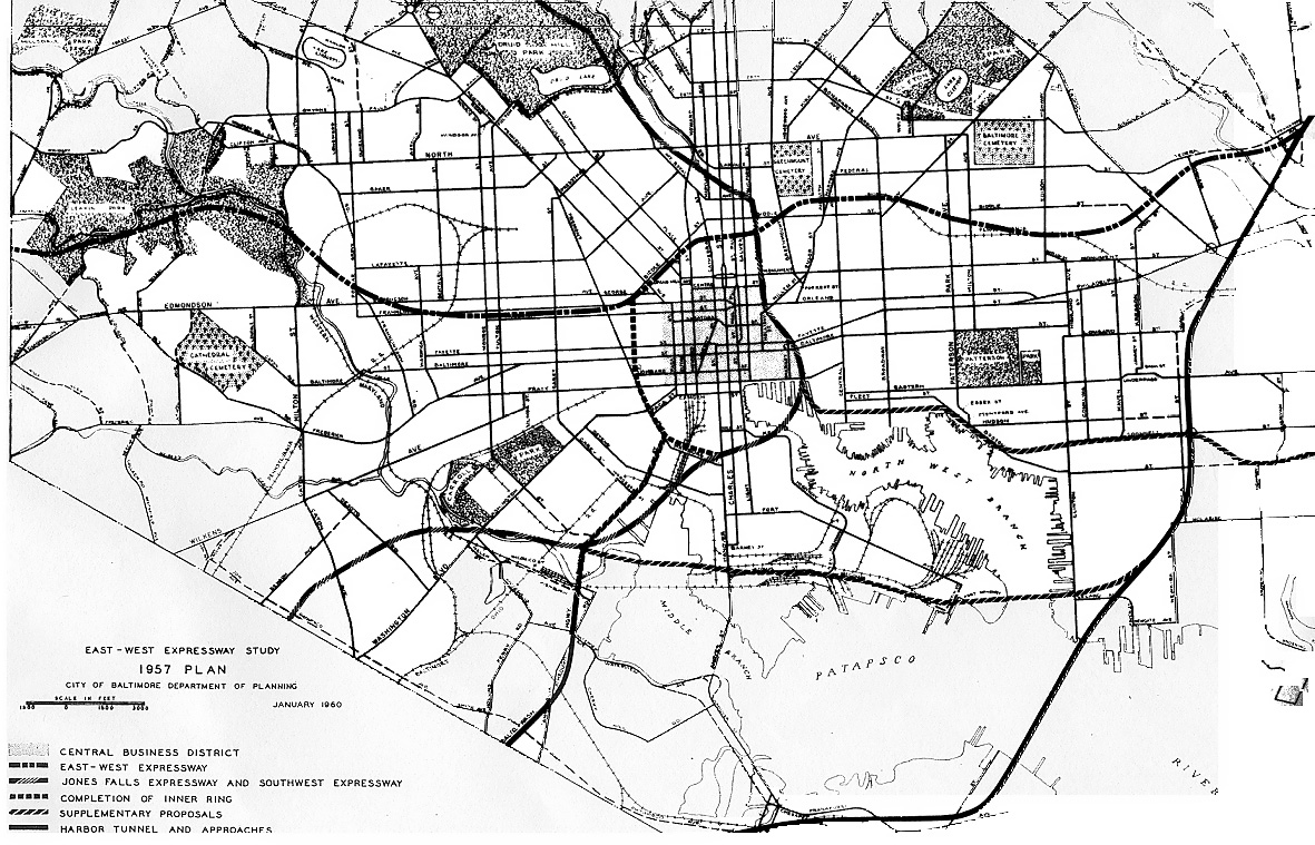
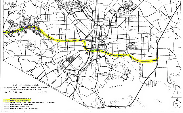
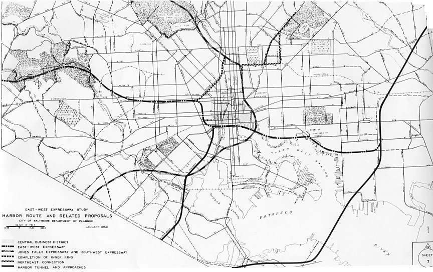
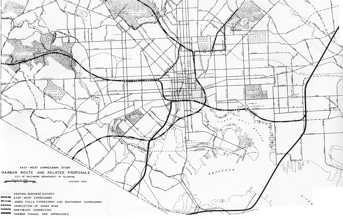
The following map reflects the 1960 recommendation of the Department of Planning study, at the conclusion of the study.
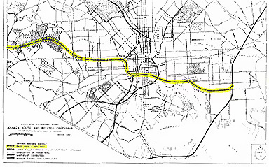 |
"East-West Expressway" (highlighted by me in yellow) and "Jones
Falls Expressway and Southwest Expressway" are the major decisions of the
BDoP study. In this study, the East-West
Expressway follows the Harbor Route where it passes just south of the central
business district. "Completion of Inner Ring" is a non-Interstate future expressway proposal. "Northeast Connection" is a surface thoroughfare project. "Harbor Tunnel and Approaches" was opened to traffic in 1957. Click for larger map images: Medium (164K), Large (225K), Extra Large (433K). The best detail is on the largest image. |
| Harbor Route and Related Proposals, from A Study for an East-West Expressway, Sheet 7, by the City of Baltimore, Department of Planning, January 1960. |
In the report, A Study for an East-West Expressway, by the City of Baltimore, Department of Planning, January 1960 (I have a copy of the report), the total cost for the Northern Route of the East-West Expressway was estimated at $194 million, for 10.2 miles of 8-lane freeway between the western city line and the Northeast Expressway (today’s I-95 JFK Highway). The total cost for the Harbor Route of the East-West Expressway was estimated at $200 million, for 12.5 miles of 8-lane freeway between the western city line and the Harbor Tunnel Thruway, and that would include 3.0 miles of overlap with and 8-lane widening of a section of the 4-lane Harbor Tunnel Thruway (today’s I-895). These sections would have been part of the national Interstate highway system, and would have received 90% federal-aid highway funding for engineering, right-of-way and construction.
The Northern Route and the Harbor Route were two alternatives, of which only one would be chosen. Each route had in common the section between the western city line, and Myrtle Street just west of the central business district; and from Myrtle Street eastward the Northern Route passed north of the CBD, and the Harbor Route passed south of the CBD (see the maps just above).
The amount of right-of-way acquisitions would have been extensive. Both routes would have in common the section between the western city line, and Myrtle Street just west of the central business district; and there would have been 1,989 dwelling units (quality: good 5.7%, fair 65.4%, poor 28.9%) acquired on that section. The Northern Route section between Myrtle Street and the Northeast Expressway, would have required the acquisition of 3,593 dwelling units (quality: good 21.9%, fair 53.2%, poor 24.9%). The Harbor Route section between Myrtle Street and the Northeast Expressway, would have required the acquisition of 1,198 dwelling units (quality: good 0, fair 29.2%, poor 70.8%). The report details the numbers of dwellings by section and quality of condition, and the condition ratings utilized federal housing standards. The Northern Route would also involve the acquisition of 6 churches, while the Harbor Route would involve acquiring no regular church buildings. The report also lists 18 major business buildings that would need to be acquired on the Northern Route, and 4 major business buildings on the Harbor Route.
As we can see, the right-of-way numbers heavily favor the Harbor Route, in that in all categories, the Harbor Route had much lower impacts to the human environment, than that of the Northern Route.
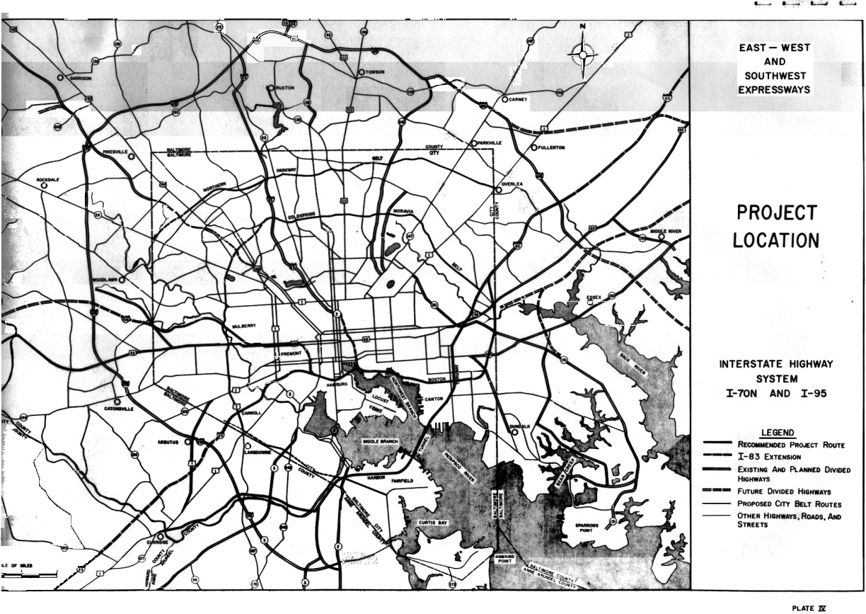
The following map is from the study, Interstate Highways 70N and 95, the East-West and Southwest Expressways, Baltimore, Maryland, Preliminary Engineering Report, prepared for the Department of Public Works, City of Baltimore.
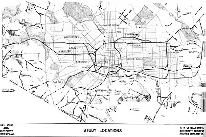 |
Click for larger map
images: Large (278K), Extra Large (439K). The best detail is on the largest image. |
| Study Locations, Plate VIII, East-West and Southwest Expressways, from the Expressway Consultants study. This shows all the alternates that received in-depth study. |
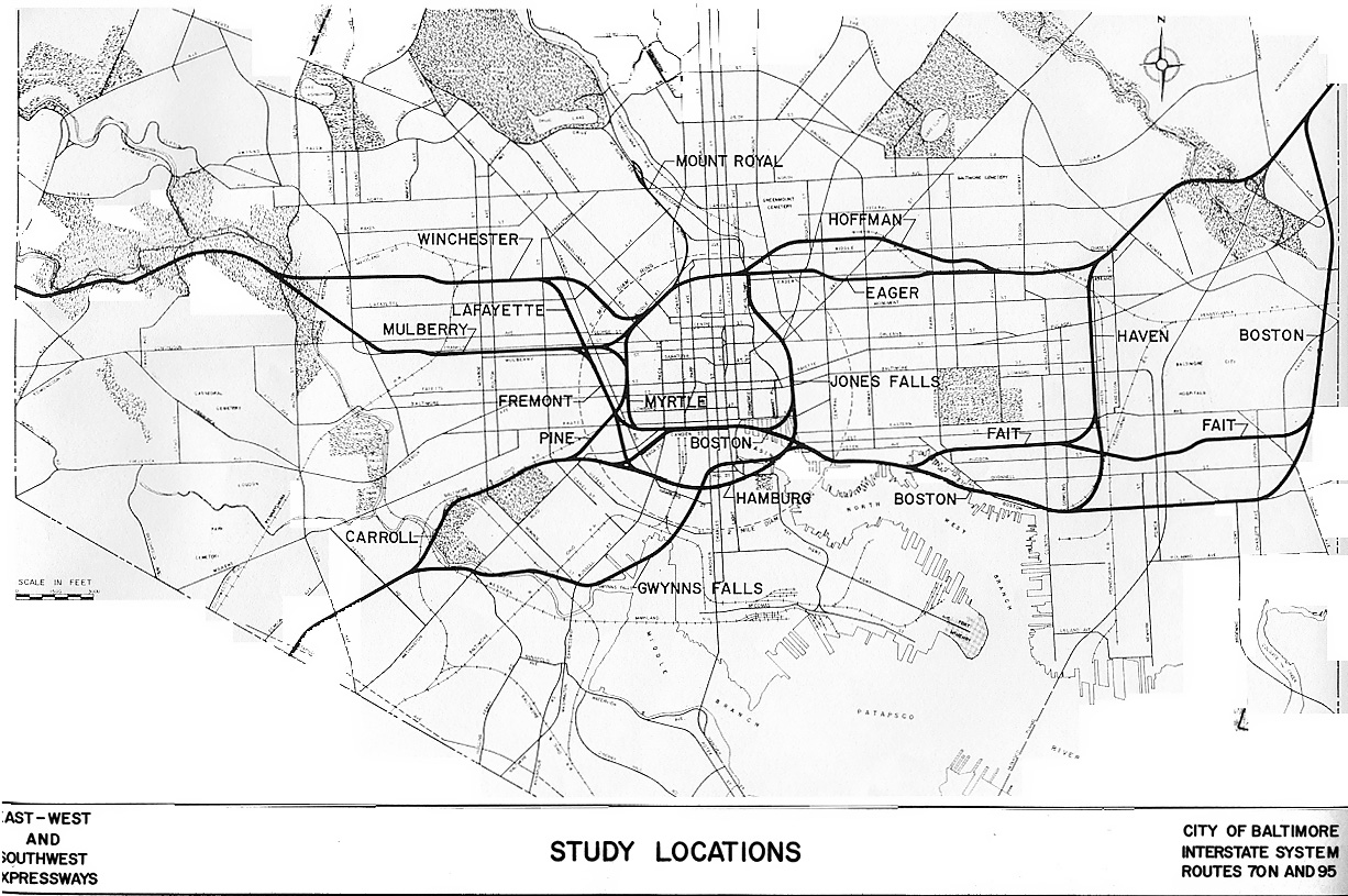
The following map reflects the 1961 recommendation of the Expressway Consultants study, at the conclusion of the study, Interstate Highways 70N and 95, the East-West and Southwest Expressways, Baltimore, Maryland, Preliminary Engineering Report, prepared for the Department of Public Works, City of Baltimore.
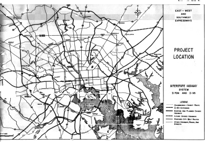 |
Click for larger map
images: Medium (182K), Large (278K), Extra Large (439K). The best detail is on the largest image. |
| Study Locations, Plate VIII, East-West and Southwest Expressways, from the Expressway Consultants study. This shows the final conclusion of the study, which was the 10-D Interstate System.. |
Expressways in the Downtown and Inner Harbor Area
The article shows aerial renderings of the BDoP 1960 proposal, and the Expressway Consultants 1961 proposal. The Expressway Consultants proposal had one major difference from the BDoP proposal, it deleted the elevated expressway viaduct that passed through the south edge of the CBD along the north edge of the Inner Harbor. It's proposed East-West Expressway junctioned I-83 at the same place, but crossed the Inner Harbor and followed the BDoP Southwest Expressway alignment westward to near the junction of Fremont Avenue and Washington Boulevard, then following the BDoP East-West Expressway alignment from there westward. The Southwest Expressway was shifted westward to a junction with the East-West Expressway near the Fremont-Washington junction. An Inner Harbor tunnel was never seriously considered, since the roadway grade from the lowest point of the tunnel to the elevated viaduct would have been prohibitively steep.
The Inner Harbor Bridge was a key feature of both proposals. As I mentioned before, it would cross the Inner Harbor on a 6- or 8-lane fixed bridge with 50 feet of vertical navigational clearance; that is the height requested by the Maryland Port Authority, and it was agreed upon by the highway planners. Tall ships with masts as high as 95 feet still used the Inner Harbor, and these would be blocked by the bridge. Surprisingly, the article implied that there was some degree of regional acceptance to building this bridge.
See my article "East-West Expressway Harbor Route - Aerial View" for an aerial view of the downtown with the proposed expressways in the Department of Planning proposal, from A Study for an East-West Expressway, by the City of Baltimore, Department of Planning, January 1960.
Completion of East-West and Southwest Expressway Studies
The cost estimates of the two proposals ranged from $214 million to $238 million, which was a very expensive highway system for the early 1960s, but since the system was included in the Interstate highway system, it was affordable (90% federal-aid highway funds, 10% state funds). There were no insurmountable engineering problems, although there were several major challenges on the Pratt Street (BDoP) route. The elevated highway along the north edge of the Inner Harbor would rest on soft soil, and it would require piles to be driven at least 125 feet down to reach bedrock. A large power substation on West Pratt Street presented a difficult obstacle to negotiate. A cemetery at St. Paul's Church in West Baltimore was in the path of the proposed expressway, and the eminent domain laws of the city and state did not allow condemnation of a cemetery, so they would have to negotiate any such relocation. There was some degree of agreement worked out with the church toward relocating the cemetery, and one proposal was designed that would avoid the cemetery, and another proposal was designed to pass the expressway under the cemetery in a tunnel that would be almost a block long.
Leakin Park Environmental Impacts
The Department of Planning, and Expressway Consultants proposals both involved an I-70N alignment through Leakin Park and Gwynns Falls Park in West Baltimore. The only alternative to the park alignment would be to build the expressway further south, through neighborhoods near Edmondson Avenue, requiring the removal of hundreds of homes. The I-70 alignment in the later 3-A System was similar, in that it passed through the park. Since Baltimore does not have large amounts of parkland, there was growing opposition to building an expressway through a city park, even though the city had plans to acquire an equivalent amount of new parkland, so that the total amount of parkland would not be diminished by the new highway. The city kept this promise, by purchasing in the mid-1960s the Windsor Estate adjacent to Leakin Park. Still, the later controversies led to local groups and environmental organizations and the national Sierra Club to the filing of lawsuits in court to attempt to stop the construction. This alignment proposal was active until the early 1980s, when it was finally cancelled. The federal highway funds allocated for the segment from the city line to the I-170 junction were transferred to provide full funding for the Baltimore Metro (rapid rail transit) Owings Mills Extension (Section B) from Reisterstown Plaza Station to Owings Mills Station.
The Leakin Park alignment was the only East-West Expressway route ever favored in far West Baltimore, since it was tied to an already established entry point at the western city line for the Frederick-to-Baltimore Interstate highway, and the alternatives of putting the expressway to the north or to the south of the park would require the removal of close to a thousand high-grade residential dwelling units.
Here is what the Department of Planning's A Study for an East-West Expressway, January 1960, specified this about the East-West Expressway's Leakin Park section (excerpt in blue text):
From the western city boundary to Hilton Street the route passes through Leakin Park and Gwynns Falls Park. While it would normally be undesirable to use park land for highway purposes, the City owns a very large amount of park land in this general area, and those portions needed for the Expressway would, for the most part, be located in the high isolated rugged areas south of Dead Run. In effect, the Expressway path jumps from hill to hill and approximately one-third of the total length within the park would be elevated. There would be no interference between the Expressway and any developed sections of the park, nor would there be any conflict with present foot or vehicle circulation within the park. Most present entrance roads into the City are unsightly; this one would have great beauty. Total park land required would be about 85 acres, of which about 35 would be needed for the Hilton Street interchange. This reduction in park acreage can be replaced in whole or in part by the purchase of additional vacant land adjacent to the park. Already two parcels at the western end of Leakin Park have been acquired to prevent development in the path of the Expressway. When the Expressway requirements have been met there will remain about 25 acres in these two parcels which can easily be added to the park. The only alternative to the use of park land at this point would be to run the Expressway through the high-grade residential areas to the north or to the south.See my article "I-70 in Leakin Park" for plan views of I-70 as it was proposed through Leakin Park in 1970.
The article discussed the Baltimore Beltway (I-695) and its impact on the city's urban expressway planning. The first metropolitan beltway in the country was Route 128 around Boston, completed in 1951. The Baltimore Beltway was the first beltway completed in the National System of Interstate and Defense Highways. The Interstate system was initiated by the 1956 Federal Highway Act.
The Baltimore Beltway was completed in 1962 as a 6-lane 36-mile-long circumferential expressway bypass of the city, although it did not become a 53-mile-long full circle until 1977 when the eastern portion was completed across the Outer Harbor. The portion completed in 1962 ran from MD-2 Governor Ritchie Highway south of the city, around the south, west and north of the city, to US-40 Pulaski Highway northeast of the city; and it passed through Anne Arundel and Baltimore Counties, entirely outside the city of Baltimore. The Beltway had 32 interchanges, including all the radial expressways and arterials which crossed it.
The Baltimore Beltway actually had its genesis in 1949 as a project of the Baltimore County Planning Commission. The Baltimore area had numerous radial arterials already in place, but there were no highways connecting the various suburban communities, places such as Linthicum, Catonsville, Pikesville, Towson, Parkville, Essex, and Dundalk. These communities had grown up on the radial highways which head out of the city, and the Beltway was intended to link them together, as well as provide an expressway bypass of the city of Baltimore.
The Baltimore Beltway project started as a county project funded by local taxpayers, but the state of Maryland took over the project in 1953. In 1956, the project was included in the Interstate Highway System, and Interstate funds (90% federal funds from the Highway Trust Fund and 10% Maryland state highway funds) provided nearly all the funding, and nearly all the construction took place after 1956.
Baltimore County was already experiencing a boom in suburban housing, and the Beltway stimulated even more economic growth. Downtown department stores began opening branches in suburban malls. Commercial and industrial concerns began establishing suburban locations, some of which were new to the area, and some of which relocated from the city of Baltimore. The Beltway offered easy access for commuters and commercial trucking, and the 32 interchanges provided easy access to large amounts of land.
For instance, the Social Security Administration, a federal agency formerly housed in 11 downtown office buildings with a total of about 600,000 square feet, moved its seven thousand employees to an 80-acre tract near the Beltway and the Woodlawn community in the western suburbs. Industrial concerns also saw the benefit of Beltway locations, with the plentiful land and easy access for workers and trucks. In another example, the Maryland Paper Box Corporation's main manufacturing plant was formerly located at Ostend and Leadenhall Streets in South Baltimore, and that and three other city plants were relocated and consolidated on a 16-acre tract in a 200,000-square-foot new building on Old Annapolis Road near the Beltway southwest of the city in Baltimore County.
In March 1958, Philip Darling became the head of Baltimore's Department of Planning. He had a background in civil engineering and city planning, and just before becoming head of BDoP, he was head of the Baltimore Urban Renewal and Housing Agency (BURHA). The MHS article describes Darling's reaction to the Baltimore Beltway development. He considered the Beltway to be a major economic threat to the city of Baltimore, similar in magnitude to the economic threat Baltimore faced in 1825 when the Erie Canal opened in New York State. The city's response then was to provide financial support for the Baltimore & Ohio Railroad, which was the nation's first commercial railroad; and the railroad (which was a new technology at the time) helped keep Baltimore competitive in the western trade.
Darling believed that in response to the beltway-oriented development, that Baltimore needed to build a modern urban expressway system, with full 4-direction access to the downtown, plus connections to the Beltway and other major arterials. This radial (downtown to suburb) expressway system would compete with the Beltway, and allow commuters and trucks easy access to downtown jobs and stores, plus easy access to city businesses and industries. The downtown was no longer the center of the region's transportation system, because of the switch from streetcars to automobiles and busses after World War II; Darling believed that urban expressways were needed to fully restore accessibility to the downtown, so that the suburbanites could have easy access to the downtown.
One of these radial urban expressways was already under construction. The 6-lane Jones Falls Expressway was begun in the early 1950s, and it runs from the downtown northward to suburban Towson and Timonium; north of the Beltway, the highway was called the Baltimore-Harrisburg Expressway, because it runs to Harrisburg, Pennsylvania. When the Interstate system was begun in 1956, this whole planned expressway was designated Interstate 83. A 2-mile section overlaps the Beltway (I-695). I-83 is 34 miles long in Maryland.
Baltimore's Department of Planning produced the document A Study for an East-West Expressway, and released it in January 1960. It has aerial photographs of the city showing the proposed expressway drawn in, plus a complete set of drawings of the route. A section of the report discussed the aforementioned economic threat of the Beltway, and explained why this proposal was better than the previous proposals. A large section "Pros and Cons of Expressways" extensively discussed the expressway, and it was forthright in explaining potential problems such as noise and blight, while concluding that urban expressways solve more problems than they cause.
The MHS article goes on to describe the development process for the expressway, specifically discussing issues such as the impacts on the various neighborhoods affected and the routing alternatives considered, plus the concerns about the impacts of the Inner Harbor Bridge, issues about the elevated expressway passing along the north edge of the Inner Harbor, adjacent to the south edge of the downtown; plus concerns about a St. Paul's Church cemetery that was in the path of the preferred alternative, plus concerns about the impacts to the Federal Hill and Fells Point neighborhoods, plus concerns about a large power substation that would need to be acquired, plus major environmental concerns about routing the expressway through Leakin Park. There were various revisions to the Expressway Consultants proposals, with controversy and disagreements by the various public and private organizations involved. The biggest problems listed were the inability to arrive at a consensus among the various organizations, plus the growing opposition by communities along the proposed routes.
The article discussion gets rather involved as it discusses this process, and I would recommend that the interested reader obtain a copy of the Maryland Historical Magazine, Volume 93,2 (Summer 1998). The URL of the Maryland Historical Society is
http://www.mdhs.org, and you can phone them (410-685-3750) for details; I sent them a letter with $6.50 for the magazine (a small book) and $2.00 for shipping. I may add this section to my article later, but most of it is very detailed.The Maryland Historical Society Magazine article seemed to jump from the end of the East-West Expressway controversy to the end of the city expressway controversies in the mid-1980s, without really mentioning the intervening 15 or 20 years. My "Baltimore City Interstates" website article basically starts at the point where the 10-D Interstate System was officially approved in 1962; this represents the study result of Expressway Consultants. I mentioned the opposition to the expressway passing the downtown/Inner Harbor area, and how a design concept team was developed to revise the proposed city expressway system. The result of this team study was the 3-A Interstate System that was approved by the city, state and federal government in 1969. Individual segments still were subject to the required federal NEPA requirements to prepare Environmental Impact Statements (EIS), plus final review and final approval by the respective agencies.
Baltimore 3-A Interstate and Boulevard System
The Maryland Historical Society article has a very comprehensive bibliography, and practically all of the article seemed accurate based on my past knowledge and readings. However, I was a bit puzzled that it didn't discuss what happened after the East-West Expressway fell out of favor, namely the development of the 3-A System, of which about half was built, including all of I-95, I-395, and City Boulevard (MLK Jr. Blvd.), plus part of I-170. The extension of I-70 into the city was cancelled, and the federal highway funds allocated were transferred to fully fund the Owings Mills extension (Section B) of the Baltimore Metro rapid rail transit line. The extensions of I-170 and I-83 were cancelled, and the federal highway funds were transferred to various other regional road projects, including I-97, I-195, and I-595 (US-50 John Hanson Highway reconstruction). Additional transferred funds were used to fund Jones Falls Boulevard, which is a 0.75-mile-long 6-lane arterial extension from the end of I-83 southward to provide adequate transition from the end of the expressway to the city street system; other transferred funds were used for reconstruction of streets through the Fells Point and Canton areas, these were not expansions, but pavement replacements so that traffic from the downtown eastward could be handled properly. See my "Baltimore City Interstates" website article for all the details.
I've stated before on this website and on Usenet that the 3-A Interstate System was well superior to all the previous expressway system plans. The author of the MHS article personally stated that the downtown routing of the East-West Expressway would have been beneficial, and that the elevated expressway would not have interfered with the Inner Harbor redevelopment plans (Harborplace, National Aquarium, Oriole Park at Camden Yards, etc.) which were carried out in the 1970s through the 1990s. He cited Boston USA and Sydney, Australia as examples where harbor elevated expressways did not prevent later successful waterfront development, but I personally think that the city did the right thing by removing them via the 3-A System concept. In addition to the expressways which were built, downtown Baltimore today has 2 rail transit facilities, the Baltimore Metro subway and the Central Light Rail Line, both of which are covered in extensive articles on this website.
Internal Links to Related Articles of Mine
Baltimore City Interstates
Baltimore Interstate System Map
Baltimore Harbor Interstate System Map
Baltimore 10-D Interstate System Map
Baltimore History of Expressway Planning
- 1970
Fort McHenry Tunnel
Baltimore Harbor Crossings
Copyright © 1998-2003 by Scott Kozel. All rights reserved. Reproduction, reuse, or distribution without permission is prohibited.
By Scott M. Kozel, Roads to the Future
(Created 10-24-1998, updated 6-15-2003)