
| Washington D.C. Interstates and Freeways |
Washington D.C. Interstates and Freeways
In the 1950s, 1960s and 1970s, there was a plan to build a complete freeway system in the District of Columbia, with urban connections to the national Interstate highway system. The plan underwent several revisions, and it was refined to the point of the design study, District of Columbia Interstate System, by DeLeuw, Cather Associates and Harry Wesse & Associates, LTD, 1971, prepared for the District of Columbia Department of Highways and Traffic, in cooperation with the U.S. Department of Transportation, Federal Highway Administration. This was the last official preliminary design for the D.C. Interstate highway system.
The Southwest/Southeast Freeway was completed in D.C. in the late 1960s. This included the 9th Street Expressway/12th Street Expressway one-way pair, which essentially comprises a north-south freeway spur from the Southwest Freeway to Constitution Avenue, passing under the Washington Mall. The original modern 14th Street Bridge was completed in 1950, and the 14th Street Bridge details are in my article 14th Street Bridge Complex (I-395 and US-1). The 14th Street Bridge and the Southwest Freeway were designated I-95. The I-295 Anacostia Freeway and the I-295 11th Street Bridge were completed in the late 1960s, and I-295 runs from the I-95/I-495 Capital Beltway near the Woodrow Wilson Bridge (over the Potomac River) to the Southeast Freeway, after crossing the 11th Street Bridge (over the Anacostia River).
There was a plan to build an freeway loop around the center of the city, and the road was called the Inner Loop or Inner Loop Freeway. Planners referred to the various segments as the Southwest Freeway, Southeast Freeway, South Leg, West Leg, North Leg, East Leg, and Center Leg. The Inner Loop would actually have been a double loop, an oval with a center leg. The entire Southwest/Southeast Freeway was built, as was most of the Center Leg (today's I-395 from the Southwest/Southeast Freeway to New York Avenue), a short piece of the East Leg from the 11th Street Bridge interchange to Pennsylvania Avenue SE, and the entire West Leg (I-66). The West Leg construction included the E Street Expressway, an east-west freeway spur in the E Street NW corridor, from I-66 to about 5 blocks east of there.
I-95 crossed the 12-lane 14th Street Bridge from Virginia, followed the Southwest Freeway, and headed up the north-south Center Leg. The Center Leg of the Inner Loop passes two blocks west of the U.S. Capitol Building under a reflecting pool, and it runs in the Mall Tunnel, which is 3,400 feet long, with 8 lanes. The Mall Tunnel has twin tubes, each designed for 4 lanes and 2 full shoulders, and the tunnel was built by the cut-and-cover construction method. I saw it when it was under construction, and there was a giant excavation trench about 50 feet deep, with green wooden barricades to block the sight of it from the street. The roadway is below sea level, so a concrete gravity slab over 10 feet thick was constructed as a base slab to resist the hydrostatic pressure. The tunnel has reinforced concrete walls, and the ceiling has closely-spaced transverse steel girders with a concrete roof slab on top. When the $100 million Mall Tunnel and approaches opened in 1973, it was designated as I-95.
When it became apparent that I-95 would not be completed through D.C., the entire route of I-95 from I-495 at Springfield, Virginia to New York Avenue in D.C. was given the Interstate spur designation of I-395, and the entire eastern half of the I-495 Capital Beltway became I-95; this took place in 1977. In 1989, the I-495 designation was added back to the eastern half of the Beltway, making it I-95/I-495.
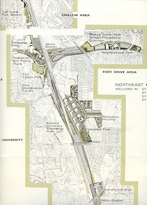
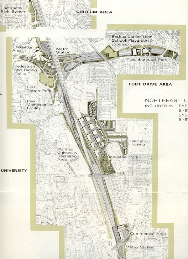
If I-95 had been completed according to the original plans, it would have continued from the Center Leg to north of New York Avenue, and it would have junctioned the North Leg of the Inner Loop, turned east, and followed the North Leg, which would have paralleled the New York Avenue corridor, about a block to the north of it. At the B&O Railroad corridor (today's CSX Transportation), I-95 would have turned northward as the North Central Freeway, following the railroad corridor to beyond the Brookland area, being tunneled (cut and cover) for 3/4 mile from south of Rhode Island Avenue to north of Michigan Avenue, then leaving the railroad corridor at Fort Totten Park, heading northeast into Maryland as the Northeast Freeway, passing west of Hyattsville and College Park before junctioning I-495 at the I-95/I-495 interchange that was completed in 1971. I-95 would have had 10 lanes on the North Leg and North Central Freeway, and 8 lanes on the Northeast Freeway. While this freeway planning was going on, the planning was also underway to build the Metrorail Glenmont Route (rapid rail transit, Red Line trains) along the railroad mainline; that was completed up to the Silver Spring Station in February 1978, to the Wheaton Station in September 1990, and the terminal Glenmont Station and line opened in July 1998.
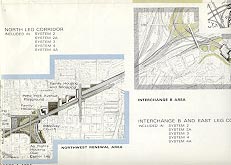
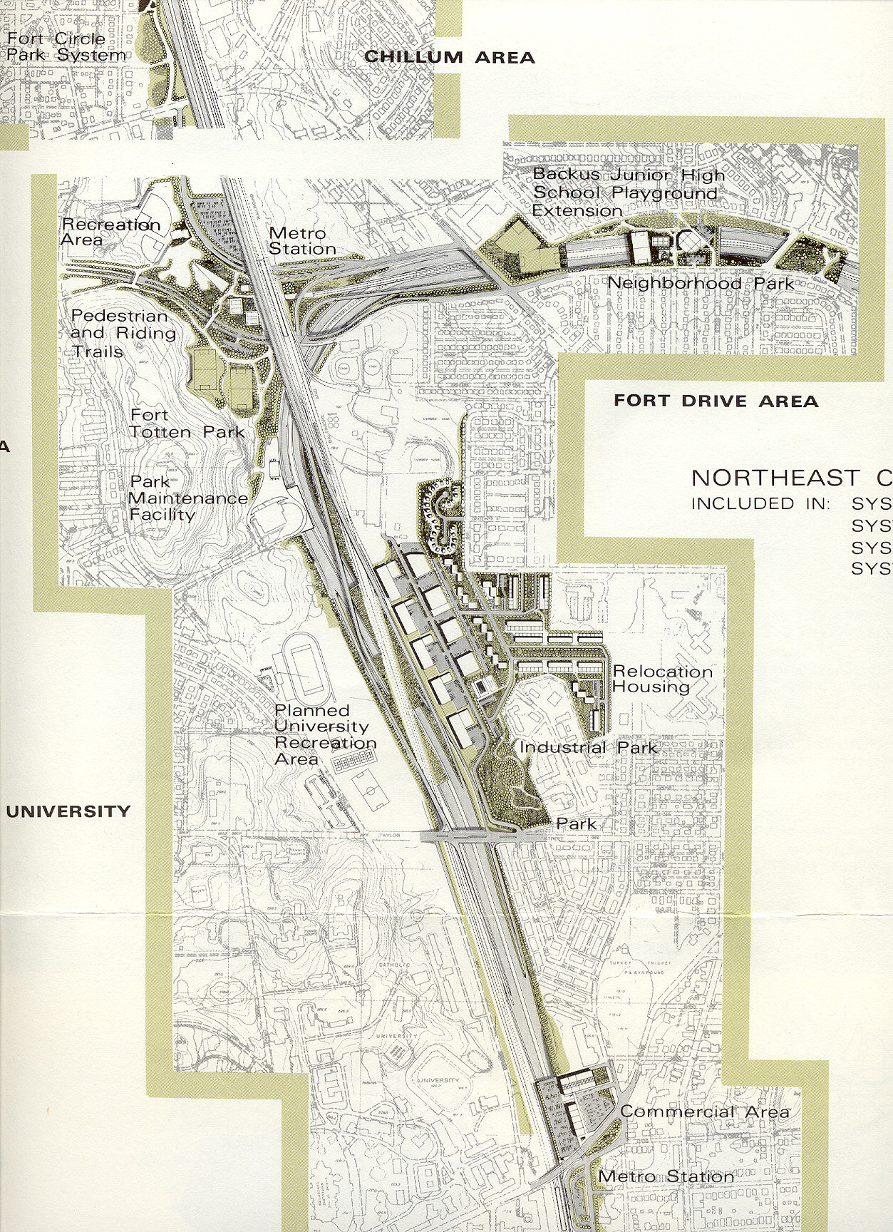
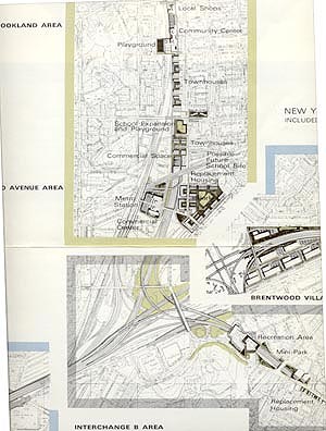
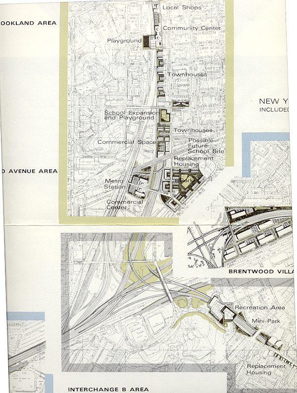
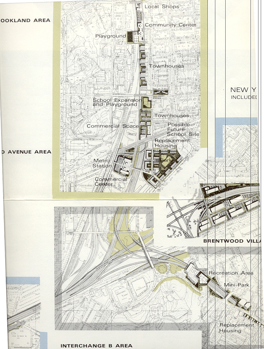
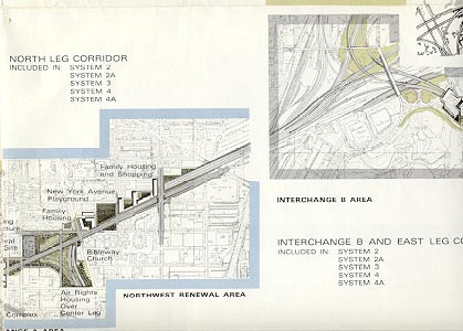
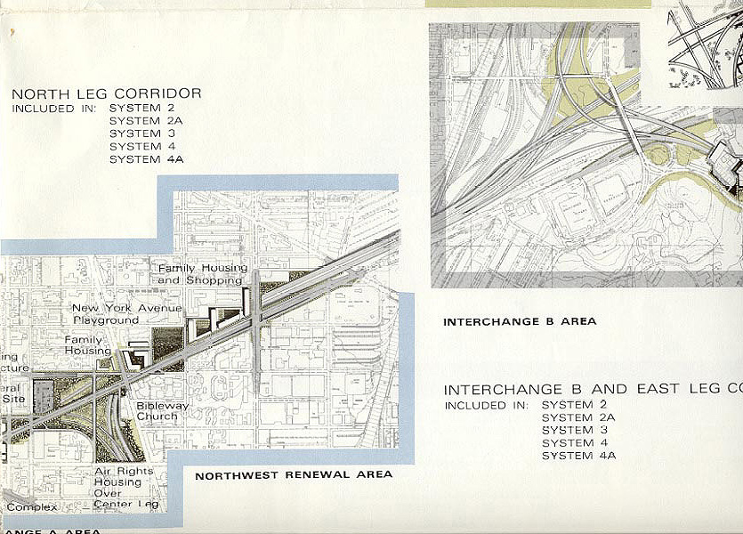
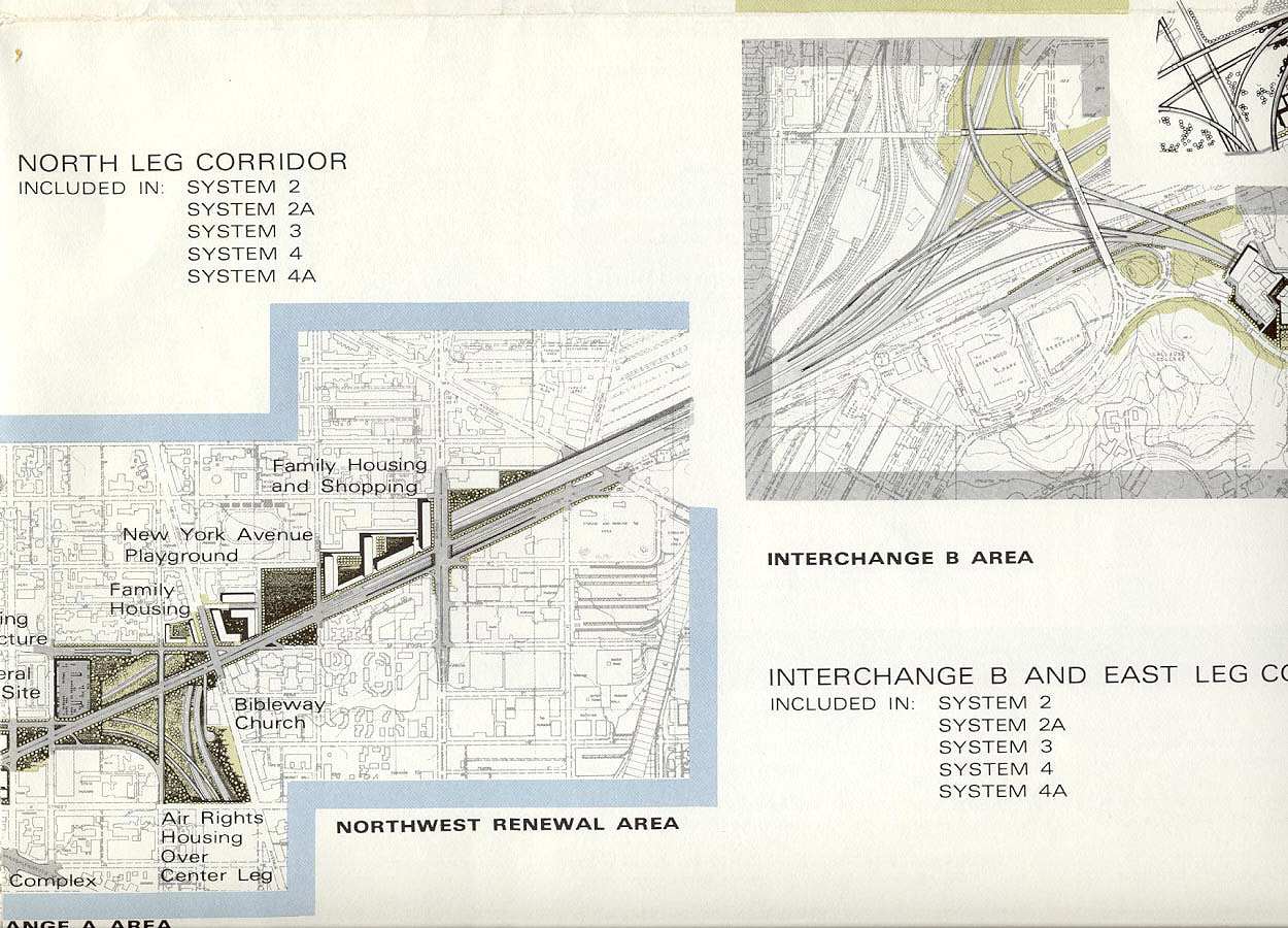
The map images below show the proposed D.C. I-95 route in the 1971 design study. The three sections show I-95 from the Center Leg (3rd Street Tunnel) at New York Avenue, to the D.C. boundary east of Fort Totten. Enlargements of these images are available on the links. Interchange "B" on the maps is the interchange in the Brookland area between the I-95 North Leg of the Inner Loop, the I-295 East Leg of the Inner Loop, and the US-50 New York Avenue Industrial Freeway.
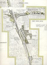 |
Click for larger map images: Small (63K), Medium (201K), Large (610K), Extra Large (1121K). Notice the decked/tunneled section south of Fort Totten, then the over 90-degree turn to the east, then the decked/tunneled section between Galloway Street and Gallatin Street, with the Metrorail Glenmont Route (Red Line trains) following the North Central Freeway (I-95 south of Fort Totten and I-70S north of Fort Totten), and with the Metrorail Greenbelt Route (Green Line trains) following the Northeast Freeway (I-95 east of Fort Totten). The area between Galloway Street and Gallatin Street where the Northeast Freeway was proposed was mostly open fields then and still is now. |
 |
Click for larger
map images:
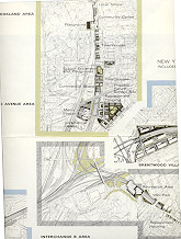
Small (35K), Medium (236K),
Large (532K), Extra
Large (931K). Notice the decked/tunneled
section alongside the B&O Railroad (CSXT today).
|
 |
Click for larger
map images: Small
(34K), Medium (237K),
Large (421K), Extra
Large (763K). Notice the decked/tunneled
section along New York Avenue.
|
The I-70S North Central Freeway with 6 lanes would have continued from where I-95 left the B&O Railroad corridor at Fort Totten Park, following the railroad all the way north, passing near Takoma Park in a 1/2-mile long tunnel, and ultimately junctioning I-495, overlapping I-495 for a few miles until it reached the I-70S/MD-355 junction at Pooks Hill. I-70S was redesignated I-270 in February 1975.
The I-66 portion of the North Leg of the Inner Loop would have extended from the present I-66 terminus near the Watergate Apartments at K Street NW, extending as the North Leg under K Street NW in a tunnel, and emerging east of Mount Vernon Square and junctioning with I-95 about a mile north of the U.S. Capitol Building. The I-66 portion of the North Leg would have had 6 lanes. The I-66 K Street Tunnel was the solution to the original I-66 alignment that would have run east-west through urban neighborhoods alongside Florida Avenue NW, and between T and U Streets NW about a half mile north of K Street NW. If the K Street Tunnel had been built, it would have been a cut and cover design, about 1.5 miles long, buried out of sight under the straight 147-foot wide avenue, and passing under Mount Vernon Square, and it would have run from near Watergate almost to today's New York Ave./I-395 junction. I-66 crosses the Potomac River from Arlington, Va. to D.C. on the Theodore Roosevelt Bridge, which opened on June 23, 1964.
The I-695 South Leg of the Inner Loop would have been tunneled (cut and cover) near the Lincoln Memorial and under the Tidal Basin. The South Leg would have been 6 lanes wide, and connected I-66 to the (then I-95) Southwest Freeway and the 14th Street Bridge.
The I-295 East Leg of the Inner Loop would have extended from its end at Pennsylvania Avenue SE (near the interchange of the I-695 Southeast Freeway and the I-295 11th Street Bridge), passing near Robert F. Kennedy Stadium, and looping around and connecting to I-95 and the New York Avenue Industrial Freeway. It would have passed through an 0.5-mile long cut-and-cover tunnel near Mt. Olivet Road NE. The East Leg would have had 6 lanes.
The New York Avenue Industrial Freeway would have continued eastward from the interchange junction of the North Leg, East Leg, and the North Central Freeway, extending to the existing US-50 freeway. The NYAI Freeway would have had 6 lanes and would have carried the US-50 designation. It and the rest of the US-50 freeway (John Hanson Highway) from D.C. to Annapolis, Maryland could have easily been designated I-66, if the US-50 freeway was upgraded to Interstate standards. I-66 and I-95 would have overlapped for about 3/4 mile on the North Leg. To my knowledge, the I-66 designation was never officially planned to go beyond the I-95 Center Leg interchange.
I-266 would have branched from I-66 near the Spout Run Parkway in Arlington, Virginia, and would have crossed the Potomac River into D.C. on the Three Sisters Bridge (named after the small Three Sisters Islands), then followed the river east to the Whitehurst Freeway, which would have been reconstructed as I-266, and I-266 would have ended at I-66 at K Street NW. I-266 would have had 6 lanes and it was essentially a parallel corridor to I-66. The original I-66 proposal would have provided 8 lanes from the Dulles Airport Access Road junction to the I-266 junction, and 6 lanes from I-266 to the Theodore Roosevelt Bridge. So in effect, the 8-lane I-66 corridor, as it approached D.C., would have become a 12-lane corridor on two freeways. Also, I-266 would have connected to the Palisades Parkway in D.C., which would have paralleled the Potomac River to Maryland and connected to the existing George Washington Parkway. I-266 in D.C. would have been known as the Potomac River Freeway. A construction contract was begun in 1972 for the Three Sisters Bridge substructure, but the contract was suspended by a court injunction several months later, and then cancelled a few months later by DC DPW. That happened at the same time that a court injunction stopped the design process on the I-66 extension in Virginia from the I-495 Capital Beltway to the Theodore Roosevelt Bridge. The design process for I-266 never restarted, while a revised 4-lane version of I-66 was placed under construction in 1977 and opened in 1982. Details are on Roads to the Future I-66 article Interstate 66 and Metrorail Vienna Route. See Mike Hale's article Interstate 266 Unbuilt.
I-595 was not part of the 1971 study, and it was authorized to the Interstate system in 1968. It was to run 1.1 mile from I-95 (today's I-395) near the Pentagon to the VA-233 Airport Connector. About 0.4 mile of I-595 was built when I-95 (Shirley Highway) was reconstructed (completion 1975), and was not signed as I-595. The I-595 proposal was essentially an Interstate spur from I-95 to Washington National Airport, plus an upgrade of the busy US-1 Jefferson Davis Highway. US-1 as a 4-lane undivided roadway passed through the growing Crystal City area. Crystal City today is a high-density development of office, condominium, apartment and hotel towers, and shopping centers. Much of I-595 would have been an 8-lane elevated freeway on an embankment with concrete retaining walls, elevated high enough to pass over crossing streets. A construction contract was awarded in 1975 to build the 0.7-mile remainder of I-595, but a court injunction stopped the construction several months later. The continuing rapid growth of Crystal City to the west of US-1 had brought the original plan into question, since it would be then seen as a barrier dividing Crystal City. A new plan was devised that provided a mostly-at-grade US-1 6-lane boulevard, with two grade separations, one interchange, and two at-grade intersections. This provided a US-1 freeway with full control of access from I-395 (old I-95) to 0.7 mile south at 20th Street, and at-grade limited access for another 0.6 mile. The project continued as a 6-lane arterial for another 0.5 mile, to south of Glebe Road, including a widened bridge over Four Mile Run. This was constructed with Interstate substitution funds and completed in mid-1988. A large portion of the Metrorail Blue Line opened on July 1, 1977 (Blue Line opens from National Airport to Stadium-Armory - 18 stations and 12 miles of line), it passes under this road, and it includes a station in Crystal City. At the I-395 interchange, there is a major fork with the VA-110 expressway branching from the US-1 freeway. VA-110 runs by the Pentagon, to Rosslyn, directly connecting to I-66 west.
The cost estimate to complete the full District of Columbia Interstate system (I-66, I-95, I-266, I-70S, I-295, I-695) was under $2 billion if it had been built in the 1970s. This cost included the portions of I-95 and I-70S (today's I-270) from the D.C. border to the I-495 Capital Beltway in Maryland, and the portion of I-266 in Virginia. This included 3,650 job displacements, and 1,166 occupied dwelling unit displacements, with extensive construction of (perhaps total) replacement housing. The 1971 study book shows plan views of many nearby places with proposed replacement housing, replacement local shops, new community centers, new commercial centers, new industrial parks, and replacement recreational parks. It looks like a good plan was in place to replace the residences, businesses and parkland that would have been displaced by the new freeways.
The estimated cost in the 1971 study for the within-D.C. remaining portions of I-66, I-95, I-70S, and part of I-295 was $780 million, with 13.2 miles of new freeways in D.C. proper. That cost did not include the I-695 South Leg, the southern half of the I-295 East Leg, or I-266, none of which involved any building acquisitions. Those three sections were part of a previous design study, and the cost estimate to build those was about $690 million (that figure from Doug Willinger's website).
The I-695 Barney Circle Freeway proposal was an attempt in the 1990s to complete a major link in the D.C. freeway system. It would have been a 1.2-mile extension of the eastern end of the Southeast Freeway/East Leg terminus at Pennsylvania Avenue SE, paralleling a CSX Transportation railroad line, crossing the Anacostia River on a new bridge, and connecting to the Kenilworth Avenue freeway just south of the East Capitol Street Bridge. It would have had 4 lanes, cost $200 million, and passed through undeveloped land. Currently there is no direct freeway connection from I-395 in Virginia and the Southeast/Southwest Freeway to the easterly and northerly freeways (US-50, Baltimore-Washington Parkway, I-95) that radiate from D.C. into suburban Maryland. The Barney Circle Freeway would have provided this, although the direct freeway connection would have used the outdated Kenilworth Avenue freeway. Major upgrading of the Kenilworth Avenue freeway would be necessary if the Barney Circle Freeway was built. The Barney Circle Freeway proposal was cancelled in 1996.
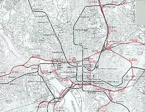
D.C. Area Interstates, Freeways and Parkways D.C. Interstate System Click on the maps for larger images.
Sources: The design study, District of Columbia Interstate System, by DeLeuw, Cather Associates and Harry Wesse & Associates, LTD, 1971, prepared for the District of Columbia Department of Highways and Traffic, in cooperation with the U.S. Department of Transportation, Federal Highway Administration. This was the last official preliminary design for the D.C. Interstate system. I-595 source: Design Public Hearing brochure, October 25, 1984, Virginia Department of Transportation. WMATA Metrorail openings: history link on WMATA website.
Douglas A. Willinger has a vast amount of well-referenced, documented and accurate information about the Washington, D.C. Interstate and Freeway system on his Takoma Park Highway Design Studio website. I have read and studied enough about the system over the last 30 years, to know that his website is very accurate and very comprehensive. Also see his A Trip Within the Beltway.
Copyright © 1997-2007 by Scott Kozel. All rights reserved. Reproduction, reuse, or distribution without permission is prohibited.
By Scott M. Kozel, Roads to the Future
(Created 8-14-1997; last updated 9-16-2007)