
| Hampton Roads Crossing Study |
The Hampton Roads Crossing Study addressed what cross-Hampton Roads highway project would be needed to address future traffic needs after the completion of the I-664 Monitor-Merrimac Bridge-Tunnel crossing in 1992.
Article index with internal links
Hampton Roads Crossing Study
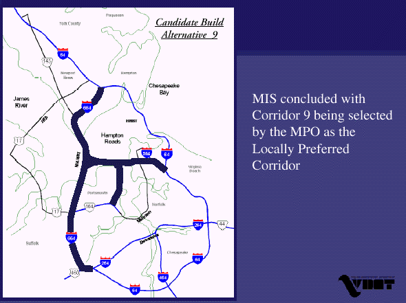
Candidate Build Alternative 9
Public-Private Proposal in 2001 to Build the Third Hampton
Roads Crossing
Intermodal Connector in Norfolk
Public-Private Proposals in 2004 to Build the Third Hampton
Roads Crossing (**4-2-2005 Update**)
My Recommendation for How to Fund the Third Hampton Roads
Crossing Project
Links to My Website Articles
Links to External Website Articles
Legend
I've tracked in others of my website articles the development of highway
facilities across Hampton Roads and the James River in the Norfolk/Hampton Roads
region of Virginia. In opening sequence, this was the two-lane US-17 James River
Bridge which opened in 1928, the two-lane Hampton Roads Bridge-Tunnel (HRBT)
which opened in 1957, the parallel two-lane Hampton Roads
Bridge-Tunnel which opened in 1976 with both HRBT facilities comprising the
four-lane I-64 HRBT, the four-lane replacement US-17
James River Bridge which opened in 1982, and the four-lane
I-664
Monitor-Merrimac Memorial Bridge-Tunnel which opened in 1992. Over many
decades, highway capacity has gradually been expanded to handle the historical
growth in highway traffic between the Peninsula and South Hampton Roads, traffic
that needs to cross the five-mile wide estuary known as Hampton Roads. The
length of the crossings and the need to cross major shipping channels, has
required the construction of some very expensive bridges and tunnels.
The Hampton Roads Crossing Study addressed what cross-Hampton Roads highway project would be needed to address future traffic needs after the completion of the I-664 bridge-tunnel crossing in 1992. The study also addressed what kind of multi-modal facilities could be included in this crossing, such as busway, high-occupancy vehicle (HOV), and passenger rail. The study started in 1993, and many public meetings and hearings were held. Two transportation committees in 1997 determined their recommendation for which alternative to choose for the new Hampton Roads Crossing in Virginia. The two committees, one with the Hampton Roads Planning District Commission, the other with the Hampton Roads Crossing Study, worked with consultant Baker Environmental Consulting, Inc. to study the alternatives.
The recommendation for the new crossing was Corridor 9, to expand the I-664 Monitor-Merrimac Memorial Bridge Tunnel (MMMBT) to 10 lanes on five separate two-lane roadways. This was favored over the "second best" alternative, Corridor 1, which would expand to 10 lanes the I-64 Hampton Roads Bridge-Tunnel (HRBT) and I-64 between I-664 in Hampton and I-564 in Norfolk. Under Corridor 9, all four existing lanes of the MMMBT would carry traffic in one direction. Four new lanes would be built to carry traffic the other way, along with two other lanes for busses or passenger rail transit. A mid-span spur from the MMMBT would carry traffic to Craney Island and to Hampton Blvd. and I-564 in Norfolk, near the U. S. Navy Base.
From Hampton
Roads Crossing Study, presented to VDOT in July 2000 (file is in .pdf
format).
The planning name for the selected Corridor 9 alternative is the Third Hampton Roads Crossing.
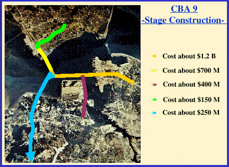
The entire I-664 corridor would be widened, from I-64/I-264 in Chesapeake to I-64 in Hampton, having 10 lanes north of the Norfolk spur, and 6 lanes south of there. The Norfolk spur (might this be numbered I-564?) would run from just south of the MMMBT south island, east-west to Norfolk to I-564, and the lane configuration would be two each way and two reversible (on three separate two-lane roadways). The east section of the spur would form the long-discussed Uptown Crossing of the Elizabeth River. The full Corridor 9 project will cost $2.7 billion in year 2000 dollars ($4.4 billion if built in stages 2004-2014), and can be built in stages. For comparison, Corridor 1 would cost $1.2 billion in year 2000 dollars.
From Hampton
Roads Crossing Study, presented to VDOT in July 2000 (file is in .pdf
format). The proposed staging is in the order that the segment costs are
listed.
The VDOT website has a site with details about the Hampton Roads Third Crossing, with links to a Study Area Map, the Final Environmental Impact Statement, and the Hampton Roads Crossing Study as presented to VDOT in July 2000.
The selection panel believed that the Corridor 9 option is the most optimum, since it connects the region's ports, gives more ways to cross the water, cuts congestion on the HRBT, opens up Craney Island for development, reduces congestion on Hampton Boulevard in Norfolk, reduces congestion on the Midtown Tunnel, provides another major entrance to the U.S. Navy Base in Norfolk, and improves traffic flow on I-64 on the Peninsula and in South Hampton Roads.
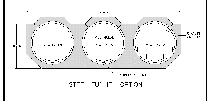
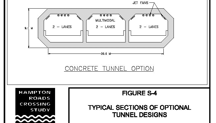
The new tunnel will comprise three tubes with two lanes each. The three tubes would be in a single sunken tunnel element. Including the existing two two-lane MMMBT tubes (which are also in a single sunken tunnel element), the entire facility will have five tubes, each with two lanes. Four tubes will be for general-purpose lanes, and one tube will be multi-modal, for HOV/busway/rail transit. The I-664 South Island will be expanded to make room for the new tunnel portals, and the I-664 North Island (actually a peninsula) at the tip of Newport News will also be expanded to make room for the new tunnel portals. The expanded MMMBT will surpass the Fort McHenry Tunnel (which has eight lanes in four separate tubes) in Baltimore as the widest underwater highway tunnel in the world. The two-lane multi-modal roadway will run from Newport News, through the tunnel complex, then onto the Norfolk spur, into Norfolk. The Elizabeth River Uptown Crossing will be a tunnel, with the west portal on a manmade island, and the east portal in Norfolk about 500 feet from the shoreline.
Again, there will be two underwater tunnels constructed on this bridge-tunnel complex, each with the three tube design depicted below -- a 4,800-foot-long tunnel facility paralleling and conjoining the existing I-664 twin-tube 4-lane tunnel, and a 5,000-foot-long new tunnel facility across the mouth of the Elizabeth River.
Diagrams are from the Hampton Roads Crossing Study - Draft Environmental
Impact Statement.
Today, there are three four-lane crossings of Hampton Roads. They are the I-64 HRBT, the I-664 MMMBT, and the US-17 James River Bridge. There are eight Interstate lanes, and four arterial lanes, for a total of 12 lanes. After the expansion of the MMMBT, there will be 14 interstate lanes and 4 arterial lanes, for a total of 18 lanes across Hampton Roads.
From the
Hampton Roads Crossing Study - Draft Environmental Impact Statement, October 1999, page 19, here is VDOT's citation as to why the Hampton Roads crossings over major shipping channels are tunnels and not high-level bridges (blue text):High Level Bridges --
High level bridges were considered for all of the Transportation Corridors crossing Hampton Roads, but were eliminated from further study. A high-level bridge crossing near the Hampton Roads Bridge Tunnel or at the Elizabeth River crossing would conflict with the required clear zone of the Norfolk Naval Air Station. Also, the Navy historically has opposed a high level bridge over channels used by their ships in the Hampton Roads area. Additionally, concern has been expressed by the Hampton Roads Maritime Association that a high level bridge may limit ship size and hinder future access to the ports of Hampton Roads. There was general concurrence from the Hampton Roads Crossing Study Coordinating Committee to eliminate high level bridges from further detailed study.
Because of the high volume of warship traffic, the U.S. Navy has historically requested that highway crossings downstream of Norfolk/Hampton Roads naval installations be in a tunnel under the shipping channel, so that no high-level bridges would exist that could be destroyed in wartime or by terrorism, and block the shipping channel for perhaps weeks or months. See my article Bridge-Tunnel Facilities in Virginia for more details.
No definite schedule for construction has been determined yet. Tolls are a possibility on all the Hampton Roads crossings if large amounts of toll revenue bonds are needed to finance the Third Hampton Roads Crossing.
The Commonwealth Transportation Board approved the location of the third crossing of Hampton Roads in its regular meeting July 20, 2000, thereby clearing the way for VDOT to begin working on the design of the project. The board endorsed the locally favored option (Corridor 9) that doubles the I-664 Monitor-Merrimac Memorial Bridge-Tunnel and adds connections to Craney Island and Norfolk. The board determined that this option would significantly reduce congestion at the Hampton Roads Bridge-Tunnel, address future growth in Hampton Roads, and provide connections to ports and major freight corridors. Estimated cost of the total project is $2.7 billion in 2000 dollars. It would be completed in five phases, and area residents would experience substantial traffic relief with the construction of the first two phases of the Third Crossing at an estimated cost of $1.9 billion. The next step for the project was the completion of the Final Environmental Impact Statement (FEIS) in late 2000 and the issuance of the Record of Decision by the Federal Highway Administration (FHWA).
VDOT's news release on July 20, 2000, "Governor Gilmore Applauds Commonwealth
Transportation Board's Approval of Location For Hampton Roads Third Crossing",
had this to say (blue text):
After a comprehensive study of alternatives by the Virginia Department of Transportation, the Board this morning approved the location of the project and cleared the way for VDOT to begin working on the design. The board endorsed the locally favored option that doubles the Interstate 664 Monitor-Merrimac Memorial Bridge-Tunnel and add connections to Craney Island and Norfolk. The Board determined this option would significantly reduce congestion at the Hampton Roads Bridge-Tunnel, address future growth in Hampton Roads and provide connections to ports and major freight corridors.
The estimated cost of the total project is $2.7 billion in current dollars. The approved location of the Third Crossing will allow it to be constructed in five phases. Hampton Roads residents would experience substantial traffic relief with the construction of the first two phases of the Third Crossing at an estimated cost of $1.9 billion. The next step for the project will be the completion of the final Environmental Impact Statement in late 2000 and the issuance of a record of decision by federal authorities. VDOT will begin the final design in early 2001. Construction will be scheduled as future funding becomes available.
Description of approved Candidate Build Alternative 9 --- From the
Hampton Roads Crossing Study - Draft Environmental Impact Statement (blue text):The Commonwealth Transportation Board approved the location of the Third Hampton Roads Crossing in October, 2000. Candidate Build Alternative 9 would provide a new crossing parallel to the existing I-664 Monitor Merrimac Memorial Bridge Tunnel with a connection from the new bridge tunnel to Norfolk and Portsmouth. On the Peninsula, Candidate Build Alternative 9 begins at the I-64 interchange in Hampton and would widen I-664 to the I-64/I-264 interchange in Chesapeake. Candidate Build Alternative 9 includes a new interchange near the south approach structure of the Monitor Merrimac Memorial Bridge Tunnel connecting to a new roadway and bridge tunnel extending from I-664 to I-564 in Norfolk. This new interchange would provide access to both the existing Monitor Merrimac Memorial Bridge Tunnel as well as the new parallel bridge tunnel. Candidate Build Alternative 9 also includes a connection along the east side of Craney Island to VA 164 (Western Freeway) in Portsmouth.
A paralleling, three-tube tunnel typical section to the west of the existing I-664 Monitor Merrimac Memorial Bridge Tunnel would cross Hampton Roads. Two of the tubes would carry two lanes each of eastbound vehicular traffic. The third tube would be used for multimodal travel, and would be dimensioned to accommodate all multimodal possibilities: HOV, passenger rail and/or bus travel. Westbound vehicular traffic would use the four travel lanes in the existing I-664 tunnel tubes. A three-tube tunnel typical section would cross the entrance to the Elizabeth River and connect to Norfolk. Eastbound and westbound vehicular traffic would be carried in two of the tubes, while the third tube would be used for multimodal travel.
Design: Two bridge-tunnels with 4 conventional travel lanes, and 2 lanes for multimodal use. Widen I-664 on the Peninsula to 8 conventional travel lanes and 2 additional lanes for multimodal use. Widen I-664 on the Southside to 6 conventional travel lanes. New roadway from the interchange over the water south of the Monitor Merrimac Memorial Bridge Tunnel to I-564 in Norfolk with 4 conventional travel lanes and 2 lanes for multimodal use. Widen I-564 in Norfolk to 8 conventional travel lanes and 2 additional lanes for multimodal use. New roadway to VA 164 in Portsmouth with 4 conventional travel lanes.
Accommodated Modes: SOV, HOV, Trucks, Buses, Passenger Rail
The Commonwealth Transportation Board approved
the Candidate Build Alternative 9 location for the Hampton Roads Third Crossing
on July 20, 2000. Following is
a verbatim copy of the resolution from the Final Environmental Impact Statement
(in blue text):
RESOLUTION OF
THE COMMONWEALTH TRANSPORTATION BOARD
July 20, 2000
Title: Location :
I-64 Hampton Roads Third Crossing
WHEREAS, in accordance with the statutes of the Commonwealth of Virginia and
policies of the Commonwealth Transportation Board, Location Public Hearings were
held from 4:00 p.m. to 7:00 p.m. on January 24, 2000, at the Heritage High
School located at 5800 Marshall Avenue in the City of Newport News, March 1,
2000, at the Sewell’s Point Elementary School located at 7928 Hampton Boulevard
in the City of Norfolk, and March 2, 2000, at the Churchland Academy Elementary
School located at 4061 River Shore Road in the City of Portsmouth, for the
purpose of considering the proposed Location of the I-64 Hampton Roads Third
Crossing; State Project: 0064-114-F12, PE-102, Federal Project NH- 64-3(341);
and
WHEREAS, proper notice was given in
advance, and all those present were given a full opportunity to express their
opinions and recommendations for or against the proposed project as presented,
and their statements being duly recorded; and
WHEREAS, the economic, social, and
environmental effects of the proposed project have been examined and given
proper consideration, and this evidence, along with all other, has been
carefully reviewed.
NOW, THEREFORE, BE
IT RESOLVED that the Location be approved as Candidate Build Alternative 9 in
accordance with the plan as proposed and presented at the said Location Public
Hearings by the Department’s Engineers.
The Final Environmental Impact Statement (FEIS) for this project was
completed in March 2001, with the FHWA approval signoffs occurring then.
Hampton Roads Crossing Study - Final Environmental Impact Statement.
Following are more excerpts from the FEIS. The
first excerpt refers to the project's origin and history (in blue text):
Section 1107 of the Intermodal
Surface Transportation Efficiency Act of 1991 (ISTEA) allocated demonstration
funds for “…highway projects demonstrating innovative techniques of highway
construction and finance.” The I-64 crossing of Hampton Roads was included as
one of these innovative projects. In 1992, the Virginia General Assembly passed
Joint Resolution 132, which directed the Virginia Department of Transportation
(VDOT) to conduct a study on congestion at the Hampton Roads Bridge Tunnel. The
subsequent VDOT study stated that short-term measures would not solve congestion
at the Hampton Roads Bridge Tunnel, and that a long-term, large-scale solution
would be required. The Hampton Roads Crossing Study was initiated in 1993 in
response to these two actions, and the results of the VDOT study.
Regarding the selection of the Locally
Preferred Alternative (LPA), from the FEIS (in blue text):
MPO Selection of Locally Preferred Alternative: On July 16,
1997, the Hampton Roads Metropolitan Planning Organization (MPO) recommended
Transportation Corridor 9 as the Locally Preferred Corridor based on the MIS
findings and citizen input from the MIS public hearings. The MPO also endorsed
continuing to improve and study the CSX corridor for a transit component.
CTB Endorsement of Locally Preferred Alternative: On September 18, 1997, the Commonwealth Transportation Board (CTB) passed a resolution which expressed its good faith intent to facilitate and develop the Hampton Roads Transportation Crossing identified as Transportation Corridor 9, which consists of a facility that includes a Bridge/Tunnel from I-564 in Norfolk to I-664 in Newport News with a connection from this new facility to the Western Freeway (Route 164), in Portsmouth and with the CSX Transportation Corridor on the Peninsula for the transit component as adopted by the MPO.
The Hampton Roads Crossing Study Draft Environmental Impact Statement (DEIS) was published in October of 1999, and DEIS/Location Public Hearings were held on January 24, March 1 and March 2, 2000 (Hearings previously scheduled for January 26 and 27, 2000 were cancelled due to inclement weather and rescheduled for the March dates.). This FEIS incorporates, by reference, the analysis contained in the DEIS and responds to comments on that document. This FEIS also identifies Candidate Build Alternative 9 as the Preferred Alternative.
Regarding details of the selected
alternative, from the FEIS (in blue text):
3. Candidate Build Alternative 9
Candidate Build
Alternative 9 would provide a new crossing parallel to the I-664 Monitor
Merrimac Memorial Bridge Tunnel with a connection from the new bridge tunnel to
Norfolk and Portsmouth. On the Peninsula, Candidate Build Alternative 9 begins
at the I-64 interchange in Hampton and would widen I-664 to the I-64/I-264
interchange in Chesapeake. Candidate Build Alternative 9 includes a new
interchange near the south approach structure of the Monitor Merrimac Memorial
Bridge Tunnel connecting to a new roadway and bridge tunnel extending from I-664
to I-564 in Norfolk. This interchange would provide access to both the existing
Monitor Merrimac Memorial Bridge Tunnel as well as the new parallel bridge
tunnel. Candidate Build Alternative 9 also includes a connection along the east
side of Craney Island to VA 164 (Western Freeway) in Portsmouth.
A paralleling, three-tube tunnel typical section to the west of the existing I-664 Monitor Merrimac Memorial Bridge Tunnel would cross Hampton Roads. Two of the tubes would carry two lanes each of eastbound vehicular traffic. The third tube would be used for multimodal travel, and would be dimensioned to accommodate all multimodal possibilities: HOV, passenger rail and/or bus travel. Westbound vehicular traffic would use the four travel lanes in the existing I-664 tunnel tubes. A three-tube tunnel typical section would cross the entrance to the Elizabeth River and connect to Norfolk. Eastbound and westbound vehicular traffic would be carried in two of the tubes, while the third tube would be used for multimodal travel.
Termini: Peninsula, I-64 and I-664 interchange in Hampton. Southside, I-64 and I-564 interchange in Norfolk; I-64, I-664, and I-264 interchange in Chesapeake; and VA 164 in Portsmouth
Design: Two bridge-tunnels with 4 conventional travel lanes, and 2 lanes for multimodal use. Widen I-664 on the Peninsula to 8 conventional travel lanes and 2 additional lanes for multimodal use. Widen I-664 on the Southside to 6 conventional travel lanes. New roadway from the interchange over the water south of the Monitor Merrimac Memorial Bridge Tunnel to I-564 in Norfolk with 4 conventional travel lanes and 2 lanes for multimodal use. Widen I- 564 in Norfolk to 8 conventional travel lanes and 2 additional lanes for multimodal use. New roadway to VA 164 in Portsmouth with 4 conventional travel lanes.
Accomodated Modes: SOV, HOV, Trucks, Buses, Passenger Rail
Regarding details of the preferred
alternative, from the FEIS (in blue text):
VII. PREFERRED ALTERNATIVE
Results of the DEIS
study as well as public and resource agency comments were presented to the
Virginia Commonwealth Transportation Board (CTB). On July 20, 2000, the CTB
voted to identify Candidate Build Alternative 9 as the approved location
(Exhibit 1). The CTB’s decision was based on Alternative 9’s abilities to best
meet the primary project purpose and its underlying needs. In fact, Candidate
Build Alternative 9 is the only alternative that addresses all aspects of
purpose and need (see Table S-2). Candidate Build Alternative 9 also does the
best job of improving total mobility between the Southside and the Peninsula
(see Table S-2). Candidate Build Alternative 9 can also be constructed in usable
segments with each segment: 1) contributing to project purpose and need and; 2)
having logical termini and independent utility. The proposed segments for the
Preferred Alternative and the construction sequence is:
1. A new bridge tunnel and roadway from existing Monitor
Merrimac Memorial Bridge Tunnel to I-564 in Norfolk with 4 conventional travel
lanes and 2 lanes for multimodal use. Widen I-564 in Norfolk to 8 conventional
travel lanes and 2 multimodal use lanes.
2. A new bridge tunnel
parallel to existing I-664 Monitor Merrimac Memorial Bridge Tunnel with two
tubes of the tunnel carrying 4 conventional travel lanes and one tube carrying 2
multimodal use lanes.
3. A 4 lane connection from the new
facility, just east of Craney Island, running south to VA 164 in Portsmouth.
4. Widen I-664 on the Peninsula to 8 conventional travel lanes
and 2 additional lanes for multimodal use.
5. Widen I-664 on
the Southside to 6 conventional travel lanes.
Candidate Build Alternative 9 requires fewer estimated residential relocations than either of the other two alternatives. Candidate Build Alternative 9 would require the relocation of 38 residential units, potentially impacting 101 people. Candidate Build Alternatives 1 and 2 would each require the relocation of 128 residential units, with both alternatives potentially impacting 368 people. Although minor, Candidate Build Alternative 9 is also the alternative that has the least disproportionate impact on minority populations as required by E.O. 12898 (Environmental Justice). Candidate Build Alternatives 1 and 2 relocate 42 residential units occupied by minorities and 16 residential units occupied by persons of low income. Candidate Build Alternative 9 relocates 36 minority residential units and 12 low income units.
Regarding constructing the project in
segments, from the FEIS (in blue text):
As discussed previously, this project will be designed and
built in segments. This approach can be adopted because each of the proposed
segments of Candidate Build Alternative 9, the Preferred Alternative, has
logical termini and independent utility and each segment independently
contributes to serving the project’s primary purpose and underlying needs.
Because each of the segments will require years of engineering design and
construction, and because each may require sequential identification of separate
or non-traditional funding sources, it is proposed that Section 404 permits be
issued as each segment enters the final design process.
Sequential design and construction of large complicated projects is consistent with FHWA regulations and guidance (23 CFR 771.111 (f)(1) and Development of Logical Project Termini). It is also consistent with the Corp of Engineers’ general policy of only permitting highway construction projects that have independent utility and logical termini and represent single and complete projects.
Regarding the two different tunnel
designs under consideration, from the FEIS (in blue text):
Two potential tunnel designs are under
consideration: the steel tube design and the concrete tube design (Figure 2-6).
The steel tube design is similar to the existing I-664 tunnel with the exception
that three tubes are proposed. I-664 was designed as a two tube, four lane
tunnel. This tunnel design is based on a generally circular tube section that
provides space above and below the travelway for ventilation. The ventilation is
handled with a fully transverse system. Fresh air is supplied from ducts under
the traffic, passed through the travelway, and exhausted in ducts above the
ceiling. The overall height of the circular, steel tube section is 12.1 meters
(40 feet).
The concrete tube design offers some advantages over the steel tube design due to its smaller outside dimensions. The concrete tube design is rectangular in section and employs a jet air longitudinal ventilation system that supplies fresh from one end of the tunnel and pumps it longitudinally in accordance to traffic movements, prevailing winds, and climatic conditions. The overall height of the concrete tube section is 9.1 meters (30 feet). The reduced height decreases the area and volume of dredging required for the tunnel, thereby reducing excavation costs and habitat impacts. While this design is not typically used in the United States, it has been used for several European and Far East tunnels. Manufacturing of the tunnel tubes is usually done in close proximity to the project site due to their small flotation factor although long tows on other projects have met with success.
Regarding a description of the Hampton
Roads estuary, from the FEIS (in blue text):
IX. WATER RESOURCES
A. SURFACE WATERS
Hampton Roads
connects to the Chesapeake Bay, the largest estuary in North America. Hampton Roads
is formed by the confluence of the James River, the Elizabeth River, and the
Nansemond River. The James River contributes 12 percent of the total freshwater
flow to the Chesapeake Bay and has a drainage area of 26,400 square kilometers
(10,200 square miles), which is just over 25 percent of the Virginia’s land area
(DEQ, 1994). The study area also contains numerous freshwater rivers, streams,
lakes and ponds. Streams and rivers typically are wide, slow moving, and tidally
influenced, with relatively wide floodplains.
Regarding estimated tunnel dredge and
fill quantities, from the FEIS (quantities in cubic meters). I produced this
table format which duplicates Candidate Build Alternative 9 data only, from the
table in the FEIS:
TABLE 4-29
ESTIMATE OF DREDGING AND FILL QUANTITIES
| Tunnels | ||||
| Location | Excavation | Backfill | ||
|
| <
Dredging | Common Backfill | Armor Rock | Locking Stone |
| Hampton Roads | ||||
| 6 Lane Concrete | 876,062 | 191,783 | 85,994 | 53,962 |
| 6 Lane Steel | 1,188,710 | 327,265 | 103,829 | 92,098 |
| Elizabeth River | ||||
| 6 Lane Concrete | 1,717,913 |
198,322 |
88,925 | 55,802 |
| 6 Lane Steel | 2,214,059 | 342,140 | 108,548 | 96,284 |
| Islands | ||||
| Location | Fill | |||
|
Excavation |
Common Backfill | Armor Rock | Type C Stone | |
| Hampton Roads | ||||
| North Island | 0 | 264,200 | 91,900 | 298,800 |
| South Island | 0 | 302,700 | 96,100 | 296,400 |
| Elizabeth River | ||||
| East Island | 3,700 | 117,400 | 70,000 | 75,000 |
| West Island | 4,000 | 161,300 | 77,200 | 112,200 |
| Total | 7,700 | 845,600 | 335,200 | 782,400 |
As shown in FEIS Table 4-29, the concrete tunnel shows about a 25 percent reduction in dredging, a 42 percent reduction in common backfill, an 18 percent reduction in armor rock, and a 42 percent reduction in locking stone when compared to the steel tunnel quantities. This reduction can be contributed to the differences in the structural geometries of the two sections.
Regarding Description of Proposed Work, from
the FEIS (in blue text):
DESCRIPTION OF PROPOSED WORK
The Virginia Department of Transportation (VDOT), in cooperation with the Federal Highway Administration (FHWA), is proposing to construct a new bridge-tunnel crossing of Hampton Roads in southeastern Virginia. A Draft Environmental Impact Statement (DEIS) was published in October of 1999 and a Final EIS is currently being prepared. Three Candidate Build Alternatives and the No-Build Alternative were studied in the DEIS. On July 20, 2000, the Virginia Commonwealth Transportation Board voted to identify Candidate Build Alternative 9 as the preferred alternative (Figure 1). Candidate Build Alternative 9, the Preferred Alternative, provides a new crossing parallel to the existing I-664 Monitor Merrimac Memorial Bridge Tunnel, and it includes a new interchange near the south approach structure of the Monitor Merrimac Memorial Bridge Tunnel connecting to a new roadway and bridge tunnel extending from I-664 to I-564 in Norfolk. On the Peninsula, Candidate Build Alternative 9 begins at the I-64 interchange in Hampton and widens I-664 to the I-64/I-264 interchange in Chesapeake on the Southside. Candidate Build Alternative 9 also includes a connection along the east side of Craney Island to VA 164 in Portsmouth. A paralleling, three-tube tunnel typical section to the west of the existing I-664 Monitor Merrimac Memorial Bridge Tunnel has been developed for the crossing of Hampton Roads, and a three-tube typical section has also been developed for the crossing of the Elizabeth River entrance. Two of the tubes will carry two lanes each of vehicular traffic. The third tube will be used for multimodal travel and is dimensioned to accommodate all multimodal possibilities: H.O.V., passenger rail, and/or bus travel.
In order to maintain the navigable shipping channels in Hampton Roads, tunnel construction for each of the Candidate Build Alternatives will be of the submerged tube-type in which the tube sections will be placed in a dredged trench on the bay bottom in a position below the future shipping channel. Each tunnel will originate on artificial islands built on either side of the shipping channels. Candidate Build Alternative 1 will require two islands, one on each side of the Newport News Channel. Candidate Build Alternatives 2 and 9 will require three islands, one on each side of the Newport News Channel and one on the west side of the Norfolk Harbor Channel. Each of the islands will measure about 285 feet at their tops.
The Thimble Shoal Channel is proposed as a potential resource for fill material for the Hampton Roads tunnels and islands. The Thimble Shoal Channel extends from the Virginia Capes across the lower end of the Chesapeake Bay into the deep waters of Hampton Roads. Thimble Shoal Channel is presently 1,000 feet wide and approximately 13 miles long. The channel is heavily used by commercial ships and military ships, and the channel must be dredged periodically to maintain navigation. The channel is currently 50 feet deep within the 650-foot wide outbound lane and 45 feet deep within the remaining 350-foot wide inbound lane. Authorized improvements for Thimble Shoal Channel provide for deepening to 55 feet (HRMA, 1997).
Public-Private Proposal in 2001 to Build the Third Hampton Roads Crossing
The Virginian-Pilot had an article about a proposal by private
companies to fund and build this project, on May 24, 2001, "Proposals offered
for Third Crossing". Excerpts follow (blue text):
A group of companies has submitted a plan to build the
much-anticipated third bridge-tunnel to the Peninsula five years sooner and
hundreds of millions of dollars cheaper than state estimates. The group, Hampton
Roads Constructors, wants to partner with the Virginia Department of
Transportation to build 13 miles of bridges and tunnels by 2009. Financial and
construction details are confidential because the state is accepting competing
bids through June 29. VDOT has estimated the cost at $4.4 billion if the project
is built over a 14-year period. The state and local cities say the
bridge-tunnel, known as the Third Crossing, is vital to the region's economy.
The new bridge-tunnel would relieve congestion at the region's primary gateway, the Hampton Roads Bridge-Tunnel, as well as on the Midtown and Downtown tunnels between Norfolk and Portsmouth. It would also link the region's ports and increase mobility for the Navy and shipbuilding industry. The route parallels the Monitor-Merrimac Memorial Bridge-Tunnel, but splits to the east in the middle of the Hampton Roads harbor to Craney Island, where a fourth international port and a Maersk Sealand terminal are proposed. From there one leg goes south to Va. 164, and another goes east across the Elizabeth River to the Norfolk International Terminals, and over to interstates 564 and 64. Each segment would include a lane that could be used for HOVs, express buses, light rail or high-speed rail.
The article went on to say that Hampton Roads Constructors proposed starting construction in early 2003 and completing the entire complex in 2009. Under the state's plan at that time, construction would begin in 2005 and the facility would be opened in phases through 2014. Road construction needs are outstripping available state and federal transportation funding, and some major highway projects under study in the Norfolk/Hampton Roads area involve private funding participation and tolls. Virginia's Public-Private Transportation Act of 1995 (PPTA) invites private companies to propose transportation projects. They can be built as privately funded roads with no public money, or as a public-private partnership with a mix of public and private funding with the state retaining ownership. Tolls on the new facility would be the usual method of recouping the investment for the private investors. The Route 895 Pocahontas Parkway near Richmond was funded this way. Hampton Roads Constructors offered a public-private proposal for the Third Hampton Roads Crossing.
Virginia's PPTA: Public-Private Transportation Act.
An article about this public-private partnership proposal was published in Engineering News-Record (ENR) magazine on January 12, 2002. The article is
"VDOT Goes International Seeking Builder for Third
Bridge-Tunnel". ENR is primarily
oriented toward the construction industry, and they have some interesting
insights stemming from that perspective. The article had these excerpts (blue
text):
In a new round of
bidding, international companies have been invited to compete to build a new
bridge-tunnel linking South Hampton Roads and the Peninsula. In May, a group of
businesses with local ties offered an unsolicited proposal to build the
much-anticipated third bridge-tunnel. By law, the state sought competing bids in
national advertisements. None were received. Now, because the Virginia
Department of Transportation may want to use federal money for the project, it
must again seek competition, this time casting a wider net and advertising
internationally. Companies have until the end of January to submit proposals.
"The Federal Highway Administration says that for such a large project we need a
larger pool," said Tom F. Boyd, VDOT's assistant commissioner for finance.
Although the proposal in hand does not call for federal money, VDOT wants to
keep its options open. "It's better for the people of Hampton Roads because it
gives more flexibility for funding in the future," Boyd said.
The group, Hampton Roads Constructors, wants to partner with VDOT to build 13 miles of bridges and tunnels by 2009. It says it can finish the project five years sooner and hundreds of millions of dollars cheaper than state estimates. VDOT has estimated the cost at $4.4 billion if the project is built over a 14-year period. While details of the proposal have not been released, a written summary of the project hints of tolls.
The article goes on to say that Hampton Roads Constructors included some of the world's leading bridge and tunnel contractors, including Tidewater Construction Company (today's Tidewater Skanska, Inc.), a subsidiary of Skanska USA, who built the I-64 Hampton Roads Bridge-Tunnel, the Chesapeake Bay Bridge-Tunnel and the US-17 Coleman Bridge at Yorktown; also, Interbeton Inc., a subsidiary of Hollandsche Beton Groep, who built the I-664 Monitor-Merrimac Memorial Bridge-Tunnel, the I-90 Ted Williams Tunnel in Boston, and many submerged tunnels in Europe; also, Parsons Brinckerhoff and JE Sverdrup, who have designed tunnels, bridges and highways in Hampton Roads and around the world. Hampton Roads Constructors wanted to start construction in early 2003, with the opening of the entire complex by 2009. This would include all the highway segments that comprise the selected Corridor 9 alternative of the Third Hampton Roads Crossing.
In August 2002, VDOT returned five PPTA proposals for projects across the state, including the Third Hampton Roads Crossing.
From a VDOT news release on August 2, 2002, VDOT Returns
Five PPTA Proposals for Projects Across the State, excerpt in blue
text:
The Virginia
Department of Transportation (VDOT) returned today five private-sector proposals
for various transportation projects including I-81 widening and the Hampton
Roads Third Crossing. These unsolicited proposals were submitted under the
Public-Private Transportation Act of 1995 (PPTA). "The Governor and VDOT are
committed to working with the private sector to find innovative solutions to our
transportation needs across the Commonwealth," said VDOT Commissioner Philip
Shucet. "The decision to return the proposals has nothing to do with the quality
of the proposals," said Shucet. "The proposals are being returned as a result of
pending revisions to the PPTA guidelines and Six-Year Program
reductions."
Proposals returned: [...] Hampton Roads Constructors and Fluor Daniel/ 3rd Crossing proposals - These two proposals are being returned to be consistent with the pending voter referendum in the Hampton Roads region and pending revisions to PPTA administration guidelines.
The then-existing PPTA proposals for the Third Hampton Roads Crossing were also shelved due to the upcoming transportation tax referendums in Virginia in November 2002; there was a referendum in Northern Virginia and a referendum in the Norfolk/Hampton Roads area. Both referenda were voted down at the polls. The referendum in the Norfolk/Hampton Roads area would have authorized a 1 cent increase in the region's sales tax, and would have authorized $7 billion in new transportation funding over a 20-year period, including paying for the entire cost of the Third Hampton Roads Crossing.
Since November 2002, as of the November 2003 update of this article, there have been more efforts to find funding for this project.
The Virginian-Pilot
had an article about a proposal to utilize tolls to fund and build this project,
on August 21, 2003, "3rd
crossing on wish list; tolls could pay for each phase". Excerpts follow
(blue text):
A third crossing
over Hampton Roads returned Wednesday to the playbook of regional road planners
who now envision the massive project as one built in phases, with each one paid
for by tolls. The contemplated first phase would link Interstate 564 in Norfolk
by a bridge-tunnel to an Interstate 664 interchange. That would allow traffic
from Norfolk direct access to the Monitor-Merrimac Memorial Bridge-Tunnel.
Engineers like the idea because it would provide a badly needed relief valve for
traffic should major problems, such as a catastrophic accident, prohibit passage
through the Hampton Roads Bridge-Tunnel.
The first phase, estimated to
cost about $1.8 billion, would not allow more vehicles to travel back and forth
daily between the Peninsula and South Hampton Roads. Even more tunnels would
have to be added between the two sides to accomplish that, pushing the third
crossing's total cost past $4.5 billion. But tackling the project in phases
would bring the region closer to the eventual goal of making daily commutes much
smoother. The change is the latest evolution in the ongoing debate over how to
plan for costly road projects during lean economic times.
By unanimous
vote Wednesday, the Metropolitan Planning Organization added the crossing
project's first phase to a master road-building list that it has been struggling
to complete. The organization, made up of local mayors and city and county
managers, periodically revises the list to identify which roads should be built
or improved over the next 20 years.
It was the strongest endorsement yet
of tolls as a funding tool by a significant player in the road-planning process.
Like the third crossing, the Southeastern Parkway would rely largely on tolls if
the local planners' latest proposal holds.
[VDOT Commissioner] Shucet
said he expects to receive a proposal this year outlining how the private sector
could team up with Virginia to build the third crossing's first phase. Previous
public-private proposals have been rejected for not meeting criteria set by
VDOT.
What tolls would be set on the third crossing is unknown. The
Hampton Roads Planning District Commission is conducting a study to determine
where tolls will work and how much money they can be expected to generate.
Previous studies have found that placing tolls over the entire third crossing,
bridge and tunnel, would cost drivers $3 a trip.
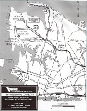
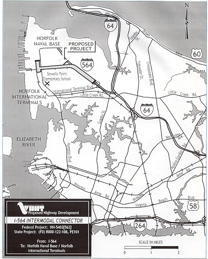
Intermodal Connector in Norfolk
The Virginia Department of Transportation is working jointly on the Intermodal Connector project with the Federal Highway Administration, U.S. Navy, Virginia Port Authority, City of Norfolk, and the Virginia Department of Rail and Public Transportation. This will be the first project built in the Third Hampton Roads Crossing.
I attended the Location and Design Public Hearing for this project. It was held on Wednesday evening, November 1, 2000 at the auditorium of Sewells Point Elementary School in Norfolk, about 1/4 mile from where the new highway will cross Hampton Boulevard. I stayed for about an hour to look at the displays and talk to the engineers and planners. There were about 30 citizens there while I was there.
This 2.6-mile-long project will be part of the future Third Hampton Roads Crossing, and it will provide immediate benefits. The estimated cost is $84.0 million for engineering, right-of-way and construction. The 2005-2010 VDOT Six-Year Program has the project programmed for preliminary engineering and for right-of-way acquisition, but not for construction. Projected average daily traffic in 2018 is 27,800.
Project purpose per the hearing brochure: "The purpose of this project is to provide a safe, high-speed, highway connection from existing I-564 to Norfolk International Terminals and Norfolk Naval Station. This highway link will provide improved access to these vital facilities and reduce vehicular and heavy truck traffic on the adjacent roadways".