
| Hampton Roads Bridge-Tunnel |
The Hampton Roads Bridge-Tunnel is the 3.5-mile-long Hampton Roads crossing for Interstate 64. It is comprised of bridge trestles, manmade islands, and tunnels under the main shipping channels for Hampton Roads harbor. It connects the City of Norfolk to the City of Hampton.
"Hampton Roads" is the historic name for the five-mile wide, last ten miles or so of the James River before it empties into Chesapeake Bay. Chesapeake Bay is an ocean estuary, the lower end of which is about 15 miles wide, and Hampton Roads is about 15 miles from the Atlantic Ocean. A line from Old Point Comfort to the west end of Willoughby Spit, comes close to demarking the point where Hampton Roads becomes Chesapeake Bay; and the Hampton Roads Bridge-Tunnel also crosses close to that line.
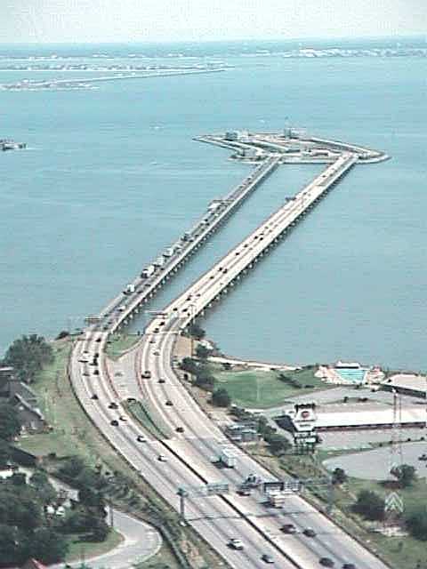
Photo by Virginia Department of Transportation,
taken about 1990.
The Hampton Roads Bridge-Tunnel (HRBT) is the 3.5-mile-long Hampton Roads crossing for Interstate 64. The HRBT and I-64 connects the South Hampton Roads cities of Norfolk and Virginia Beach with the Peninsula cities of Hampton and Newport News. The facility is toll-free and is operated and maintained by the Virginia Department of Transportation (VDOT). The HRBT tunnel holds a place as an engineering milestone: the world's first underwater tunnel connected to man-made islands.
The Hampton Roads Bridge-Tunnel has two 12-foot-wide lanes each way, on separately built structures; the original, now westbound, opened on November 1, 1957; and the eastbound structure opened on June 3, 1976. The HRBT was tolled from 1957 until the second span opened in 1976, and the tolls were removed on the day that the parallel structure opened to traffic.
The original HRBT opening in 1957 replaced vehicular ferries that operated
between Norfolk on the southside, and Newport News and Hampton on the Peninsula.
These ferries were operated by the Virginia Department of Highways, and ceased
operation after the HRBT opened to traffic. Per the 1999 Richmond Times-Dispatch
article referenced below (excerpt in blue text):
The main ferry route ran between a terminal at the end of Hampton Boulevard near
the Naval Base in Norfolk to what is now the small boat harbor near downtown Newport
News. A route that carried less traffic ran between Willoughby Spit in Norfolk
and near Fort Monroe in Hampton. The ferry ride took half an hour each way and
cost $1.25, plus an additional 20 cents for each passenger. The total daily traffic
between the two locations averaged only about 2,500 vehicles. That more than doubled
as soon as the bridge-tunnel opened.
The HRBT toll for a one-way trip across the facility, was $1.25 for an automobile, throughout the duration of the tolling from 1957 to 1976. That was a lot of money back in 1957, but no more than that of the ferry.
There were four regional tolled facilities in the same pooled toll financing system that went toll-free on June 3, 1976 when the parallel HRBT opened to traffic -- the I-64 Hampton Roads Bridge-Tunnel, the US-17 James River Bridge, the US-17 Coleman Bridge, and the VA-3 Robert O. Norris Bridge. The original HRBT was closed for renovation in fall 1976 after Labor Day, and reopened in spring 1977, and during that project, 2-lane 2-way traffic temporarily utilized the new HRBT, and upon completion of the project, both spans were permanently restored each to 2-lane one-way traffic. Lane control signals and crossovers allow emergency provision of 2-lane 2-way traffic on one of the spans, if the other span needs to be temporarily closed to traffic. The US-17 Coleman Bridge was re-tolled beginning in 1996 to finance its 4-lane expansion project.
The twin tunnels on the Hampton Roads Bridge-Tunnel are each 7,479 feet long, and the roadway is 108 feet below sea level at the lowest point. The bridge roadways are located at an elevation of 17.5 feet above the average high tide sea level, and span the remainder of the crossing. The North Approach Bridges are 3,250 feet long each, and the South Approach Bridges are 6,150 feet long each. There are two manmade portal islands to transition the roadways between bridge and tunnel, and the roadways on each are about 1,500 feet long, and the portal islands are built to an elevation of 11 feet above the average high tide sea level.
The Hampton Roads tunnels were built by the immersed sunken tube method, comprised of shipyard-built prefabricated tunnel elements each about 300 feet long, placed by lay-barges and joined together in a trench dredged in the bottom of the harbor, and backfilled over with earth.
A state-of-the-art, computer directed, traffic control system and a video monitoring system are employed to monitor and manage the traffic at the HRBT and its approaches. Air quality within the tunnels is constantly monitored and fresh air is circulated via ventilation fans injecting fresh air into the tunnels.
The parallel facility's trestles have shoulders with a width of 10 feet on the right and 6 feet on the left. The original facility's trestles were built with minimal shoulders about 2 feet wide, and major rehabilitation and widening was conducted in 1998 and 1999 to provide major rehabilitation to the substructure, widening to provide shoulders with a width of 10 feet on the right and 6 feet on the left, and a fully new bridge deck. The rehabilitation project cost $34.7 million, and was completed in November 1999.
During the peak traffic months of June through August, the number of vehicles crossing the Hampton Roads Bridge-Tunnel regularly exceeds 100,000 per day.
Sources of information: VDOT news releases and bulletins.
A Civil Engineering-ASCE magazine article called "A Tale of Three Tunnels" was published in the December 1974 edition. The article discusses three different sunken tube tunnel projects, one in Hong Kong, one in New York City, and the parallel Hampton Roads Bridge-Tunnel project. The second HRBT was completed in 1976 at a cost of $95 million.
The construction of the original $44 million Hampton Roads Bridge-Tunnel was funded with toll revenue bonds, and the bonds were paid off soon before the parallel Hampton Roads Bridge-Tunnel opened. The construction of the $95 million parallel HRBT was funded as part of the Interstate Highway System as authorized under the Federal-Aid Highway Act of 1956, which means that it was funded with 90% FHWA funds from the Highway Trust Fund and 10% state DOT funds. So the result was a toll-free highway.
"Tunnel a bridge to everywhere / Single metro
area began to develop as harbor barrier fell", by Richmond Times-Dispatch,
Virginia Century Series, Sunday, June 13, 1999. Excerpts (in blue text):
The bridge-tunnel did catch
on over the years. As average traffic exploded from just more than 5,500 vehicles
a day in 1957 to more than 81,000 last year, the formerly distinct regions on
either side of the Hampton Roads harbor gradually formed a single metropolitan
area stretching from Virginia Beach to Williamsburg and containing about 1.5 million
people. The James River Bridge between Newport News and Isle of Wight County began
the unification process when it opened in 1928, and other crossings, including
the Monitor-Merrimac Memorial Bridge-Tunnel (Interstate 664), which opened in
1992, pushed things along. Political and civic leaders have supported the transition
by creating business and government groups to represent the entire region. They
also have promoted the Hampton Roads label to replace the older popular names
of Tidewater, and Southside for the south side of the harbor, and the Peninsula
for the north side.
Hampton Roads Tunnels and Bridges, by Virginia Department of Transportation.
Aerial photo of Hampton Roads Bridge-Tunnel, taken 1991, from TerraServer.
Future
The Hampton Roads Crossing Study was commissioned by VDOT in 1995, to study an additional Hampton Roads crossing, and one of the alternates was to add six lanes to I-64 (including the HRBT) from I-564 in Norfolk to I-664 in Hampton, making the highway 10 lanes wide. That would have provided two new two-lane general-purpose HRBT roadways (one each way), plus a two-lane multi-modal roadway, and the cost for that 12-mile-long section would have been about $1.5 billion in 1997 dollars. In 1997, the Commonwealth Transportation Board decided to expand the I-664 bridge-tunnel instead of I-64, and that project is in the planning and design stages. See Roads to the Future article Hampton Roads Crossing Study for more information.
Fort Wool
The I-64 Hampton Roads Bridge-Tunnel has two manmade tunnel portal islands, at the place where Hampton Roads flows into Chesapeake Bay. The two manmade tunnel portal islands were widened to the west to accommodate the parallel bridge-tunnel project 1972-1976.
The Hampton Roads Bridge-Tunnel south portal island actually does connect to some preexisting land, about 20 acres of land that is the site of Fort Wool, a fort during the Civil War, World War I and World War II, and a public park since 1970. Fort Wool is on a manmade island known as Rip-Raps, created beginning in 1818, which was pre-existing land when the HRBT south tunnel portal island was built 1954-1957, with a small earthen causeway that connects Fort Wool to the HRBT south portal island. On the history link below, there is an aerial photo where you can see this location.
Here's a website about Fort Wool - "
Fort Wool - Hampton Roads harbor, Hampton, Virginia", Rip Raps near Norfolk's Willoughby Spit.From "
A Brief History of Fort Wool", excerpts (blue text):The island that Fort Wool sits on is man-made. Known as the Rip-Raps, it was created beginning in 1818 on a shoal and is basically a big pile of rocks. The island continued to settle after construction of the fort began in 1826 and it was still incomplete at the start of the Civil War.
A concealed radar tower was built during WWII. A submarine net closed off the harbor entrance between Fort Wool and Fort Monroe. After being decommissioned it was given to the state in 1967 and in 1970 the City of Hampton developed it into a park. The Fort Wool ferry, Miss Hampton II, allows tourists to visit the island during most of the year. But it can also be briefly glimpsed by cars entering the southern end of the Hampton Roads tunnel on Interstate 64.
Length of Hampton Roads Tunnel
Some people have asked the question, about why the HRBT tunnels are so long. The twin tunnels are each 7,479 feet long, and the roadway is 108 feet below sea level at the lowest point.
The I-664 tunnel is 4,800 feet long, and the tunnels on the Chesapeake Bay Bridge-Tunnel, are 5,738 feet long on the Thimble Shoal Channel Tunnel, and 5,450 foot long on the Chesapeake Channel Tunnel (see respective Roads to the Future articles about those others for the references). The lengths cited here are from portal to portal. All the tunnels cited cross major shipping channels that handle the largest ships in the world (except supertankers).
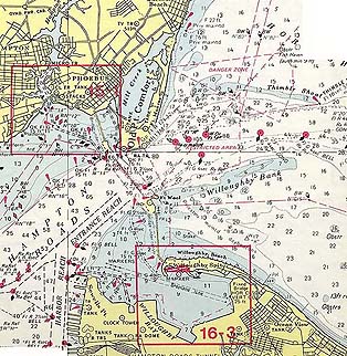
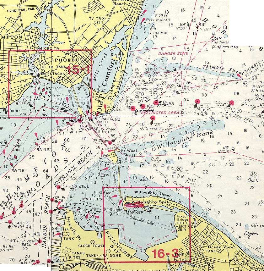
Here is the explanation, per a review of nautical charts. The centerline of the HRBT tunnels cross a naturally deep channel ranging from 50 to 60 feet deep, 1-1/2 mile wide, with water only 6 to 10 feet deep between the edge of the deep channel and each shore. That means that no dredging for shipping was needed in the naturally deep channel, since it is deeper than the 40 to 45 foot depths in the dredged channels. The manmade portal islands were built in the shallow water with the tunnels starting in the shallow water, with the tunnels passing completely under the 1-1/2 mile wide naturally deep channel.
With the high volume of commercial shipping and military shipping passing through Hampton Roads, it is logical that the highway tunnel would be built in a manner to preserve the entire width of the naturally deep channel. The I-664 and CBBT tunnels do not pass under any such wide and naturally deep channel, so their lengths are dictated only by the needs of the manmade shipping channels.
Here are scans from a 1976 nautical chart (the parallel structure was still under construction then), that show what is being discussed.