
| Hampton Roads Area Interstates and Freeways |
Hampton Roads Area Interstates and Freeways
This article discusses the Hampton Roads area, and why it got the Interstates, freeways, bridges and tunnels that it did. The Hampton Roads area today has over 1.6 million in population, and it is a vibrant area with an extensive highway system. People in Virginia most commonly refer to the southeastern part of the state as Tidewater Virginia or the Hampton Roads area. "Hampton Roads" is the historic name for the five-mile wide, last ten miles or so of the James River before it empties into Chesapeake Bay, and it is the place where the Elizabeth River and the Nansemond River empty into the James River.
The Peninsula cities of Newport News and Hampton are linked to the South Hampton Roads cities of Norfolk, Portsmouth, Chesapeake and Virginia Beach by two separate four-lane Interstate highway bridge-tunnels, and the four-lane arterial US-17 James River Bridge. The Elizabeth River between Norfolk and Portsmouth is crossed by the four-lane Interstate highway Downtown Tunnel, and by the two-lane arterial Midtown Tunnel. The Hampton Roads area is linked to the Virginia Eastern Shore by a bridge-tunnel with four-lane bridges and two-lane tunnels. The whole area has an extensive, complete freeway system.
Little of that highway infrastructure existed in 1956 when the national Interstate highway System was begun. Norfolk was a somewhat sleepy Navy town. The only fixed link across Hampton Roads was the two-lane, out-of-the-way US-17 James River Bridge that was built in 1928, and it was narrow, with a roadway deck 22 feet wide between parapets. There was a vehicular ferry from Norfolk to Hampton. Hampton Roads was a major transportation barrier that effectively divided the area into two separate metropolitan areas, with little interaction. The 3.5-mile-long Hampton Roads Bridge-Tunnel (HRBT) was two lanes wide and it opened in 1957. It wasn't until 1976 when the parallel HRBT span was built, completing Interstate 64 in the Hampton Roads area, that real highway capacity existed to truly unify the Peninsula and South Hampton Roads areas into one metropolitan area.
The US-17 James River Bridge was replaced with a modern four-lane bridge in 1982, providing more capacity. The four-lane Interstate 664 Monitor-Merrimac Memorial Bridge-Tunnel was completed in 1992, completing the beltway around the area. I-664 was not an original part of the 41,000-mile-long national Interstate System that was authorized in 1956, it was added as part of the 1,500 miles that was added in 1968. Today 12 lanes on three separate facilities provide excellent linkage across Hampton Roads.
The Elizabeth River was a major barrier also. The 3,813-foot-long two-lane Downtown Tunnel was opened in 1952, and the 4,194-foot-long two-lane US-58 Midtown Tunnel was opened in 1962. Again, in the year 1956, there was limited connection by highway between Norfolk and Portsmouth. It was in 1988 that the parallel Downtown Tunnel was opened, and the renovated original Downtown Tunnel was reopened in 1989, providing a four-lane interstate highway (I-264); and the parallel Berkley Bridge was opened in 1991, providing 8 lanes at that crossing.
It cost about $700 million to build I-664, and about $250 million to build the parallel Downtown Tunnel/Berkley Bridge complex.
In 1956, Virginia Beach didn't exist, it was Princess Anne County; it was in 1965 that it became a city.
So the upshot of all this is that in 1956, the Hampton Roads area had a fraction of the population of today, and it was divided by large water transportation barriers. Also, being near the Atlantic coast, it was not near the principal eastern seaboard north-south highways, US-301 and US-1 back then, paralleled by Interstate 95 later.
The Peninsula cities were isolated from the US-58 corridor, a reason why that corridor was not included in the Interstate system as established in 1956. An Interstate highway in the US-58 corridor between I-95 at Emporia and I-64 in Chesapeake would seem like a logical Interstate highway to connect the Hampton Roads area to I-95 to the south, but that is looking at it from the post I-664 era with the high-capacity highway connectivity that has existed between the Peninsula and South Hampton Roads, since the 1992 completion of I-664.
Hampton Roads Interstates and Freeways
VA-164 -- The Western Freeway in the Hampton Roads area is VA-164. It was opened in 1992, and runs from I-664 at Churchland to near the two-lane US-58 Midtown Tunnel (which crosses the Elizabeth River). It is about 5 1/2 miles long, and a 1 mile extension to the Midtown Tunnel is under construction. A $146 million project was started in 2002 to build the extension, the Pinners Point Interchange (Port Norfolk Connector) to the tunnel approach road, which is planned to be completed in 2005. It has been proposed to build a parallel two-lane Midtown tube, and completion of this would provide a four-lane VA-164 freeway from I-664 all the way into downtown Norfolk. This road could very easily be redesignated as I-164, although I have not heard of any such plan for an Interstate designation. Funding has not been identified yet for the Parallel Midtown Tunnel project. The Midtown Tunnel originally was tolled and had its tolls removed in 1988.
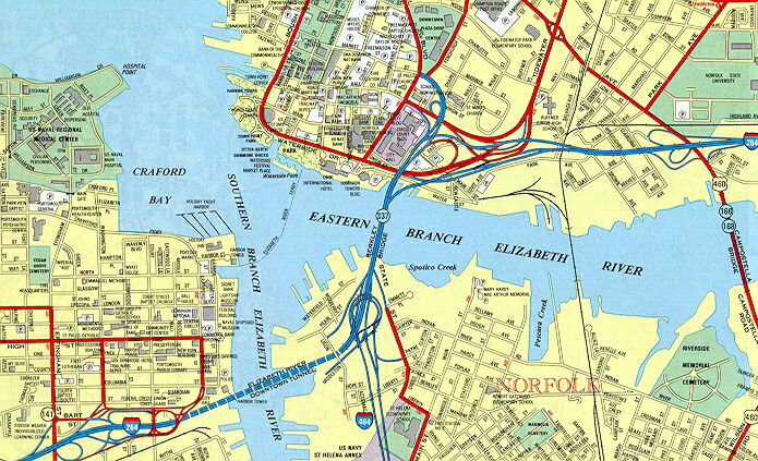
I-264 -- The 26.1-mile-long east-west freeway through Portsmouth, Norfolk and Virginia Beach (VA-44 was changed to I-264 in 1999). The originally designated 13.3-mile-long Interstate was completed in 1972 between I-64 at either end (Bowers Hill and Military Circle), and it did not include the 2.2-mile-long Downtown Tunnel / Berkley Bridge complex (completed in 1952). The Downtown Tunnel crosses the Elizabeth River, South Branch, and it had a single two-lane tube, and the Berkley Bridge crosses the Elizabeth River, East Branch, and it had a single undivided four-lane span. For years, this tunnel and bridge had to serve the I-264 corridor which had been completed on either side by 1972. Virginia got federal Interstate funding approval in 1978 to upgrade that 2.2-mile-long facility with 90% federal funding and to include it in I-264. The 2.2-mile-long project to build a parallel two-lane tube, parallel four-lane bridge, and upgraded interchanges was begun in 1982, completed in 1991, and cost about $250 million. In 1988, the parallel Downtown Tunnel was opened, and then the original Downtown Tunnel was closed for renovation and then reopened in 1989, providing a four-lane Interstate highway (I-264). At the point that the Downtown Tunnel was expanded to 4 lanes, it was the busiest 2-lane highway in Virginia with an average daily traffic of over 41,000 vehicles passing through the tunnel. In 1988, both Elizabeth River tunnels, historically tolled, had the tolls removed. The interchange between I-264 and I-464 opened to traffic in 1989. The parallel Berkley Bridge was opened in 1990, and then the original Berkley Bridge was closed for renovation and then reopened in 1991, providing an eight-lane Interstate highway (I-264). The Berkley Bridges have bascule spans with 50 feet of vertical navigational clearance when closed, making them among the few (actually 11) drawbridges on the national Interstate Highway System. The Norfolk Interchange portion of the project was completed in 1991, and this involved upgrading the downtown interchange between I-264, the Berkley Bridge, and Waterfront Drive.
During the project planning in the mid-1970s, a new high-level bridge was considered for replacing the tunnel and bascule bridge, but the confined urban waterfront area made that design impractical from the standpoint of providing adequate interchanges, because of the height of the bridge approaches above ground, which would have also towered over parts of the downtowns of Norfolk and Portsmouth. Another design considered was the replacement of the Berkley Bridge with a tunnel, but this crossing was deemed to need 8 lanes, and building a tunnel of such width would have been fantastically expensive. The officials of the local governments provided unanimous support of the design concept to retain the drawbridge and to double the number of lanes at that crossing. Fifty feet of vertical navigational clearance is sufficient to accommodate most marine traffic, and the expansion project provided twice as many lanes, which helps the backup to clear up faster after the opened drawbridge is closed. Source: Final Environmental Impact Statement for Interstate Route 264, Cities of Portsmouth and Norfolk, by USDOT FHWA and VDOT, approved in 1978.
Map of Norfolk and Portsmouth showing I-264 and I-464 detail near tunnel and bridge
I-464 -- The 5.7-mile-long north-south spur from I-64 in Chesapeake to I-264 in the Berkley section of Norfolk. Junctions I-264 between the Downtown Tunnel and the Berkley Bridge. Completed in 1989.
I-564 -- The 2.8-mile-long spur from I-64 to the Norfolk U.S. Navy Base. It was completed in 1977. Widening to six lanes was completed in 1993. I-564 has a 680-foot-long tunnel that goes under a Naval Air Station runway.
I-664 -- The 20.7-mile-long north-south freeway from the I-64/I-264 interchange at Bowers Hill in the city of Chesapeake, to I-64 in the city of Hampton near the Hampton Coliseum. Includes the Monitor-Merrimac Memorial Bridge-Tunnel (MMMBT) described earlier. Construction started in 1979 at the I-64 Hampton interchange. The northern 3 miles of I-664 followed the two-lane Newport News Connector Road corridor and opened in 1983. I-664 was extended to downtown Newport News in 1988, and to near the MMMBT in 1991. The MMMBT construction started in 1985 and it opened in April 1992. The section of I-664 from VA-135 to I-64/I-264 at Bowers Hill opened in Jan. 1991. I-664 has 6 lanes for 5 miles from I-64 in Hampton to 35th Street in Newport News, and 4 lanes for next 15 miles to US-58 in Chesapeake, and 8 lanes for the 1 mile from US-58 to I-64/I-264.
Hampton Roads Beltway -- In January 1997, the 56-mile-long I-64/I-664 loop was designated and signed as the Hampton Roads Beltway. I-64 makes a huge arc around Norfolk and Portsmouth. The beltway has the clockwise direction (as looking down at a map of the area) signed as the Inner Loop, and the counter-clockwise direction signed as the Outer Loop (same concept as the I-495 Capital Beltway). I-64 runs from St. Louis, Missouri to metropolitan Norfolk, Virginia. Since the eastern end of I-64 terminates in a beltway, there is no completely ideal numbering scheme that could be implemented. I would favor leaving it like it is, rather than changing existing the numbers.
VA-44 Virginia Beach - Norfolk Expressway -- In July 1999, VDOT renumbered the Expressway to I-264. This is logical, as VA-44 was basically an eastward continuation of the original I-264, which runs through Portsmouth and Norfolk. VA-44 is built to Interstate standards. The Expressway opened in 1967, and it runs 12.8 miles, from I-64 in Norfolk to the Virginia Beach oceanfront, and it was a toll road until 1995. The car toll was 25 cents. The original road had four lanes (two each way). It was widened to six lanes in the 1980s, and to eight lanes in the early 1990s. The toll booths were removed soon after the tolls ceased.
Road to the Future Website Articles
For more details about the above referenced
freeway, bridge and and tunnel facilities, see these articles:
Copyright © 2003 by Scott Kozel. All rights reserved. Reproduction, reuse, or distribution without permission is prohibited.
This article was created in December 2003, by combining the original Roads to the Future articles "Hampton Roads Area Interstates" and "More Hampton Roads Expressways", both of which were created on August 14, 1997; and by updating the combined information. The two older articles were deleted upon creation of the new article.
By Scott M. Kozel, Roads to the Future
(Created 12-1-2003)