
| Baltimore Outer Harbor Crossing Replacement Proposal |
The Outer Harbor Crossing was the planning name for the 11-mile-long Baltimore Beltway toll facility between MD-10 and MD-151, and it included the 1.6-mile-long Francis Scott Key Bridge over Baltimore Harbor.
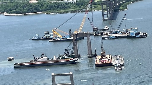
The bridge south main pier was struck by an out-of-control container ship MV Dali on March 26, 2024, and the 2,644 foot long truss structure completely collapsed.
An 8-week period ensued for salvage crews to remove the wreckage and reopen the main shipping channel.
Last updated: July 5
Original Roads to the Future article Francis Scott Key Bridge (Outer Harbor Crossing)
Note: Items marked with ★ link to standalone pages outside this main article.
Article index with links:
Section I: The Collapse and Its Technical Context
- Executive Summary
- Overview of Bridge Collapse
- MV Dali Details and Initial
Probable Cause of Incident
- Attacks on the Structural
Design of the Original Bridge
- National Transportation Safety Board --
Marine Accident Report
-
NTSB Recommends 68 Bridges in US be Evaluated for Risk of Collapse from Vessel
Strike
- More About Tides and High Water
Levels
- Coal Ship Explosion and Fire in August
2025
- 24‑Month Status Update: The Emergency That
Outlived the Emergency (added 2-24-2026)
Section II: Governance, Policy, and Institutional Behavior
- The Legislation Surrounding
the Key Bridge Rebuild
- NEPA -- Environmental Impact Statement
- Is This Loss of the Bridge an Emergency?
- Lack of Planning on Your Part is not an
Emergency in My Book
- Funding a New Crossing
- FHWA CATEX Document
- Letter sent to DOGE
- Response to Key Bridge
Rebuild Team
- New Key Bridge is Planned to be Tolled
- Project Cost and Schedule Update on
Nov. 17, 2025
- Reason Foundation Article on Key Bridge
-
The MDTA Scheme: Spectacle Without Stewardship ★
-
Key Bridge Rebuild Numbers Don't Add Up ★
-
Key Bridge Funding: A Reality Check as of March 2026
★ (added
3-12-2026)
-
Key Bridge Rebuild -- April 2026: GMP Failure, Design Freeze, and Phase 2
Re‑Procurement
★ (added
4-29-2026)
-
Key Bridge Funding and Procurement: The Reality as of May 2026
★ (added
5-30-2026)
-
Key Bridge Procurement Restructuring: July 2026 Update
★ (added
7-5-2026)
Section III: Engineering Alternatives and Technical Evaluation
- Key Bridge Conceptual
Rebuild Alternatives
- Why I Object to the Current Scheme
)
- Roads to the Future Solution -- Tunnel
- Outer Harbor Tunnel
Portal Causeways
- HRBT High‑level
Bridge Alternative
- Typical Tunnel Opposition
Talking Points
- Estimate for an Outer Harbor Tunnel
- HAZMAT Shipments
- Risks During
Construction of Cable‑stayed Bridge
- Advantages of Tunnels Over Bridges
- More on Bridge Protection Systems
- Chesapeake Bay Bridge Replacement
- Bay Bridge Protection Project
- Symbolic Overbuild and Strategic
Drift
-
Comprehensive Analysis of the Key Bridge Rebuild ★
Section IV: Comparative Incidents and Precedents
- I‑35W Bridge Collapse
- Coal Ship Explosion and Fire
-
Sunshine Skyway Disaster
★
Section V: Public Discourse and Cultural Response
-
Sample of Stuff Posted on Internet Groups
- AARoads Forum Shenanigans
- "In the Year 2525" Parody (added 3-5-2026)
-
Key Bridge Collapse: Emotional Infrastructure ★
Section VI: References and Supporting Material
- ASCE Brief Opening History (added 2-13-2026)
- Bibliography
- Legend
Executive Summary
The Francis Scott Key Bridge (1977–2024) was built as the low‑bid surface
crossing of Baltimore’s Outer Harbor, explicitly accepting what designers
called the "extremely remote" risk of catastrophic ship impact. The MV Dali
proved that risk real on March 26, 2024.
Maryland is now fast‑tracking a $4.3–$5.2 billion replacement bridge under a
Categorical Exclusion that skips full NEPA alternatives analysis and locked in
Kiewit via progressive design‑build before competitive review. Independent
federal and congressional budget analyses now place the likely cost in the
$5.5–$6.2 billion range -- above Maryland's last publicly released estimate.
A far superior, proven option exists: an immersed‑tube or TBM‑bored tunnel on
the identical 1970s Outer Harbor Crossing alignment. Using the $1.9 billion
actual 2021–2026 cost of VDOT's second HRBT 7,900‑foot twin‑tube tunnel
(similar harbor conditions, escalation already baked in), a Baltimore Outer
Harbor twin‑tube tunnel with four lanes and causeway approaches is
realistically deliverable for $1.6–$1.9 billion -- less than one‑third the
projected bridge cost.
Key advantages:
- Zero piers in the shipping channel
- No possibility of total collapse from ship strike
- Full HAZMAT routing preserved, as modern tunnels accommodate it
- Direct precedent 170 miles south on the same coast
The Baltimore Outer Harbor Crossing tunnel
portal causeways already exist. Built in 1970 for a planned 6,200‑foot tunnel,
they were repurposed only after the tunnel construction bids came in "too
high" for the agency. The bridge was placed on top of infrastructure
originally designed for a tunnel.
The current emergency CE and sole-source contract have eliminated competition
and genuine alternatives scrutiny. Returning to a normal NEPA EIS process
would force open bidding and objective comparison, potentially saving federal
and Maryland taxpayers $3-4 billion while delivering a 22nd-century crossing
instead of rebuilding a 20th-century vulnerability.
This is the road Maryland rejected in 1972 -- and the one the Dali disaster now demands we finally take.
FHWA is not obligated to fund Maryland's
preferred replacement simply because early work has begun. Emergency Relief
rules limit federal participation to the eligible cost of restoring a
comparable facility, and FHWA cannot commit to a final share without a
complete financial plan, a cost‑reasonableness finding, and a NEPA record
supporting the chosen alternative. Starting demolition and final design does
not bind FHWA to a $5.5–$6.2 billion structure.
Independent federal analyses place the comparable‑facility cost at roughly
$1.7–$1.9 billion, which functions as FHWA's practical ceiling. Maryland's
preferred design exceeds that baseline by a factor of three, and the
additional cost is not automatically eligible for reimbursement. Any gap above
the comparable‑facility threshold must be resolved by the state, regardless of
how far preliminary work has advanced.
The bridge scheme is driven by nostalgia and
optics, not by modern risk analysis. With today's vessel sizes and hazardous
cargoes operating in a busy industrial harbor, a signature bridge simply
doesn't compute. A tunnel eliminates the entire class of catastrophic
ship-impact failures and aligns with contemporary safety standards. A bridge
-- even with massive fender islands -- still leaves piers in the water for
ships to hit. Modern risk standards call for removing the hazard, not hoping a
structure survives it.
Overview of Bridge Collapse
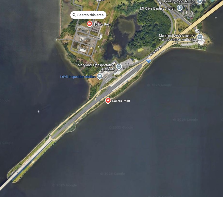
The Outer Harbor Crossing was the planning name for the 11-mile-long Baltimore Beltway toll facility between MD-10 and MD-151, and it included the 1.6-mile-long Francis Scott Key Bridge over Baltimore Harbor.
The bridge south main pier was struck by an out-of-control container ship MV Dali on March 26, 2024, and the 2,644 foot long truss structure completely collapsed.
An 8-week period ensued for salvage crews to remove the wreckage and reopen the main shipping channel.
| Key Bridge timeline for collapse and recovery | |
| March 26, 1:30 am collapse | |
| Mar. 30,31 | Large barges with cranes arriving |
| Apr. 1 | Open north temp channel |
| Apr. 2 | Open south temp channel |
| Apr. 19 | Unified Command opens third temporary alternate channel. The Fort Carroll Temporary Alternate Channel, depicted in green, has a controlling depth of 20 feet, a 300-foot horizontal clearance, and a vertical clearance of 135 feet, and will facilitate additional commercially essential vessel traffic through the port of Baltimore. Infographic courtesy of Key Bridge Response 2024 Unified Command. |
| May 21st | Removed Dali from channel |
| May 25th | Channel fully open |
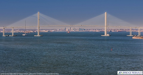
New Key Bridge Design Unveiled (extracted from KeyBridgeRebuild dot com on 8-25-2025)
On February 4, 2025, Maryland Governor Wes Moore unveiled the new design concept for the Francis Scott Key Bridge Rebuild. The governor stated that the new design honors the architectural tradition of the original bridge. The new bridge will be Maryland's first highway cable-stayed bridge, constructed according to the most advanced industry standards and best infrastructure design practices.
Bridge Features
-
Two 12-foot lanes in each direction / 10-foot-wide outside shoulders and 4-foot-wide inside shoulders per direction of travel
-
Total Bridge length more than 2 miles
-
230-foot minimum clearance from water to bridge deck above the federal channel
-
Two bridge towers more than 600 feet tall
-
Distance between main span pylons exceeding 1,600 feet
-
Total length of cable-stayed main span exceeding 3,300 feet
-
Expected life span of 100 years
This rendering has been on their website main page and banner of their Facebook page for the rebuild project for at least since early-2025:
The main piers including those concrete tubs are only about 150 feet farther
from the shipping channel, and the south main pier is in waters 35 feet deep at mean high
water (see the revised USCG permit plan view).
The real issue: MDTA's PR blunder in showing a cable-stayed bridge without the promised ship-collision protection system. Fenders or dolphins should've been in the concept to reassure the public post-Dali. It's not about final plans -- engineers are still studying -- but leaving out safety visuals is tone-deaf. This isn't a scam, just a dumb oversight.
FHWA Categorical Exclusion
issued for environmental document.
PUBLIC NOTICE
D05PN-02-2025 was issued by the U.S. Coast Guard and has the permit
information for the design chosen by MDTA.
The purpose of this website article is to evaluate the proposal of the Maryland Transportation Authority (MDTA) and to recommend alternatives.
I oppose their plans for this project, as having the same vulnerabilities as the original bridge, and having constricting effects on future of the harbor.
Baltimore’s Francis Scott Key Bridge Opens -- by Civil Engineering Almanac of the American Society of Civil Engineers (ASCE). This story originally published in March of 2021 in celebration of the Francis Scott Key Bridge's 44th anniversary.Excerpts:
Baltimore’s Francis Scott Key Bridge (not to be confused with the 1923 bridge of the same name in Washington, D.C.) is the outermost of three major Patapsco River crossings at Baltimore Harbor. Paralleling the earlier (1957) Baltimore Tunnel and later (1985) Fort McHenry Tunnel, the crossing was originally conceived as a tunnel between Hawkins Point and Sollers Point in the outer harbor. The design was changed to a bridge when tunnel construction bids proved too costly in 1970.
Construction began in 1972 and the bridge was opened to traffic on March 23, 1977. Including its connecting approaches, the total project length encompassed a 10.9-mile corridor. The bridge itself, with a total length of 8,636 feet, is a steel arch-shaped continuous-through-truss bridge structure that combines the behaviors of an arch, truss, and cantilever. With a main span of 1,200 feet, it was the second longest continuous-truss bridge span in the world when constructed and remains the second longest in the United States and third in the world.
The Legislation Surrounding the Francis Scott Key Bridge Rebuild
Emerged in response to its collapse on March 26, 2024, after being struck by a cargo ship. Congress acted swiftly to ensure federal support for reconstruction, culminating in the Baltimore BRIDGE Relief Act.
Section 3. Federal Share for Certain Emergency Relief Projects
“Notwithstanding subsection (e)) of section 120 of title 23, United States Code,
the Federal share for emergency relief funds made available under section 125 of
that title to respond to damage caused by the cargo ship Dali to the Francis
Scott Key Bridge located in Baltimore City and Baltimore and Anne Arundel
Counties, Maryland, including that bridge and its approaches, shall be 100
percent.”
MV Dali Details and Initial Probable Cause of Incident
The MV Dali is a 984-foot Neopanamax container ship weighing 116,851 deadweight tons and capable of carrying nearly 10,000 TEUs. On March 26, 2024, while departing Baltimore en route to Sri Lanka, the vessel suffered a sudden electrical failure that disabled its propulsion and steering systems. The blackout occurred at 1:29 a.m., just as the ship approached the Francis Scott Key Bridge. With no ability to maneuver, the Dali drifted into a critical support pier, triggering a catastrophic collapse that killed six construction workers and severed a vital artery of Interstate 695.
Investigations revealed that a loose wire in the ship’s control circuitry caused the power outage, and the vessel had a history of vibration issues and prior collisions, including one in Antwerp in 2016. The U.S. Coast Guard classified the incident as a major marine casualty, and the National Transportation Safety Board (NTSB) launched a full investigation. The ship was temporarily repaired in Norfolk before undergoing extensive rehabilitation in China. Legal claims exceeding $100 million have been filed, and the event has sparked renewed scrutiny of maritime safety protocols and infrastructure vulnerability. The Dali’s return to service underscores both the resilience of global shipping and the unresolved risks of large-vessel navigation near critical infrastructure.
MV Dali
was traveling at approximately 10 miles per hour, which converts to about 8.7 knots, just before the collision with the Francis Scott Key Bridge. After impact, the vessel slowed to around 7.8 mph (roughly 6.8 knots) as it absorbed the force of the crash and came to rest against the wreckage. Given the bridge’s original design and materials, it’s reasonable to estimate that 15,000 to 20,000 tons of wreckage ended up on, around, and blocking the MV Dali.The 2,644-foot continuous steel truss of the Francis Scott Key Bridge likely
weighed between 30,000 and 35,000 tons, this includes the massive triangular
framing, gusset plates, and lateral bracing that spanned the Patapsco River.
The reinforced concrete roadway deck, including rebar, asphalt overlay, parapet
barriers, and embedded utilities, adds another 60,000+ tons. With an estimated
deck width of ~85 feet and thickness of 8–12 inches, the concrete alone
contributes tens of thousands of tons, and the steel reinforcement and surface
layers compound that total. Together, the bridge’s superstructure likely weighed
90,000 to 95,000 tons, making it one of the heaviest continuous truss spans in
the U.S.
How big is 100,000+ tons?
Such large numbers can seem academic and hard to visualize.
To give readers how much 100,000 tons is, consider this -- the massive
Cape Hatteras
lighthouse weighs about 5,000 tons aboveground and about 1,000 tons below
ground.
If it was out in open waters, what do you think would happen if a 100,000+ ton
ship hit it while sailing at 10 knots?
Attacks on the Structural Design of the Original Bridge
Almost immediately some internet experts started blaming the design of the bridge, saying that it was "weak, fragile, fracture critical, etc." and that it should have been able to absorb the hit and remain standing.
The bridge didn't have a fracture critical issue. Despite what some internet
posters including one supposed civil engineer on YouTube kept claiming. The
definition of fracture critical basically means that the failure of one
subordinate (secondary) member will cause a massive failure of the whole bridge.
Like the pin-and-hanger design on the I-95 Mianus River bridge and others
whereby the failure of one beam hinge connector will lead to the collapse of the
entire bridge. That is a fracture critical bridge.
The Key Bridge didn't rely on every truss beam being intact. I don't know what
the exact number is but at least one could be removed without the failure of the
entire truss. The important word is "fracture" which suggests a crack and not a
massive destruction. Knocking out a main support pier on a long span bridge is
not a fracture, it is a disaster that will cause the entire span to
disintegrate.
How do you explain to someone the amount of kinetic energy at work here and what it can do? Some 9/11 Truthers say that since an airliner is largely made out of light aluminum structures and that the Twin Towers was a steel structure, that the plane should have gone "splat" on the side of the building with little or no penetration.
That of course is baloney any way you slice it -- you have a 150 ton object moving at 500 mph (the speed of a 45 auto pistol bullet) and it did enormous damage to the building. A 150 ton water balloon (if such a thing was possible) would likewise do enormous damage to the building. An EF5 tornado is in the 180-220 mph range and it can rip house foundations and basements right out of the ground. And that is nothing but wind. Imagine what a 500 mph tornado would do?
The Key Bridge was a continuous truss with multiple load paths. It could
tolerate localized member failure. What it couldn’t survive was the obliteration
of a main support pier, a foundational element, not a subordinate one. That’s
not a fracture. That’s a structural amputation.
The MV Dali weighed 116,851 metric tons and was moving at 8.7 knots (~10 mph).
That translates to roughly 1.6 billion joules of kinetic energy, comparable to
the explosive force of 900 pounds of TNT. No bridge designed in the 1970s (if
ever) was built to absorb that kind of lateral impact to a critical pier.
To visualize it: A 150-ton aircraft hitting a steel skyscraper at 500 mph isn’t
just aluminum vs. steel, it’s momentum vs. resistance. The plane doesn’t need to
be dense; it needs to be fast. A 150-ton water balloon at that speed would still
pulverize a structure. Mass × velocity˛ is unforgiving. An EF5 tornado, at just
200 mph, can rip homes from their foundations. Now imagine a 500 mph wind, or
worse, a solid object moving at that speed.
The Dali didn’t hit a truss beam. It hit Pier 17, which supported the main span.
Remove that pier, and the span has nowhere to go but down. The collapse wasn’t
due to a crack propagating through steel, it was due to the instantaneous loss
of vertical support. That’s not fracture critical. That’s support critical.
The Dali’s impact wasn’t just about raw energy -- it was about momentum, structural vulnerability, and instantaneous load transfer. The bridge didn’t absorb a blast -- it absorbed a moving wall of steel with the mass of 2,900 loaded tractor-trailer trucks. That’s not a fracture. That’s a blunt-force amputation.
Key Bridge Conceptual Rebuild
Alternatives as of
March 2024 -- per Roads to the Future
1. Replace the 2,644 foot long main span structure, the part that collapsed.
Use a cable stayed or cantilever structure. Replace the three plate girder spans on the
north approach that also collapsed, 895 feet total: south to north - 285, 290,
320.
Same cross section as existing bridge. This alternative may be buildable for
the $400 million minimum that has been cited in news sources, we will need to
see a detailed engineering estimate.
2. Similar to Alt. 1 except the new spans will have 10 foot right shoulders.
3. Similar to Alt. 2 except the pre-existing approach spans will be widened to
have 10 foot right shoulders.
4. Replace entire bridge on the same alignment, with maximum 2.5% grades. This
will be a longer bridge and it will have 10 foot right shoulders.
Issue: several recently built bridges over shipping channels have vertical
clearances in the 215 foot range. That is 30 feet more than the Key Bridge and
such a bridge would have a higher profile than the entire original bridge and
would necessitate replacing the entire original bridge.
5. Remove pre-existing bridge structures, build approach roadways on causeways
(that were built for the original tunnel plan) Build 6,200 foot long twin-tube
4-lane tunnel under harbor.
6. No build. Remove remaining bridge structures.
Given the flat traffic growth that has basically been stable at about 31,000 AADT since 2006, 4 lanes (2 each way) should be adequate for the design year of 2045.
I would like to see the tunnel funding be explored. I know it would be expensive but I see it as the only proper solution (other than not building any new crossing at all and letting traffic be handled on the inner harbor tunnels and their freeways).
A large enough island/dolphin system for a bridge would undoubtedly cause hydrologic problems. I really don't think it is possible to protect against ships of this size. They could build an island 1,000 feet in diameter but then in that about 5,200 foot opening it would interfere with water flows and that river is tidal there. Resource agencies tasked with environmental approvals would almost certainly oppose such a design and refuse to approve it.
Why I
Object to the Current Key Bridge Rebuild Scheme
The collapse of the Francis Scott Key Bridge was a tragedy -- but
the response posture matters just as much as the event itself. I object to the
current rebuild scheme because it reflects a pattern of expediency over
discernment, symbolic erasure over principled renewal, and infrastructure
inheritance without accountability.
No Full EIS: A Shortcut That Bypasses Public Wisdom
The decision to grant a Categorical Exclusion (CE) under NEPA sidesteps the very process designed to ensure long-term resilience, environmental integrity, and public input. A full Environmental Impact Statement (EIS) would have required serious study of alternatives -- including the tunnel option -- and forced agencies to confront freight growth, navigational risk, and climate vulnerability. Instead, we got a fast-track rebuild justified by “similar footprint” logic. That’s not stewardship -- it’s shielding.
A Vulnerable Bridge in the Same Spot
The proposed cable-stayed bridge may be elegant, but it’s still exposed. Rebuilding in the same location, with similar navigational constraints, invites future risk. The original bridge lacked protective fenders -- a fatal omission. The new design promises improvements, but without a full EIS, we’re trusting assurances over analysis. That’s not resilience -- it’s repetition.
Tunnel Option Dismissed Without Study
A tunnel would eliminate navigational risk entirely. It would preserve Baltimore’s skyline, reduce long-term maintenance, and offer symbolic closure. But it was never seriously considered. Why? Cost? Timeline? Politics? Without an EIS, we’ll never know. The dismissal of the tunnel option reflects a deeper institutional drift -- one that prioritizes speed over scrutiny.
Symbolic Geography Ignored
The Key Bridge carried symbolic weight -- named after the author of the national anthem, spanning industrial Baltimore, anchoring regional freight. Its collapse was a rupture in narrative. The rebuild should reflect that. Instead, we’re offered a structure that threads technical specs but ignores emotional infrastructure. That’s not renewal -- it’s replacement.
Funding Scheme: Expedient but Unexamined
The Key Bridge rebuild is
backed by a mix of federal emergency funds, state allocations, and insurance
claims, with early estimates placing the cost between $1.7 and $1.9 billion.
While the speed of funding approval reflects urgency, it also bypasses deeper
scrutiny. The federal government’s emergency designation unlocked fast-track
dollars, but it also enabled the Categorical Exclusion from a full Environmental
Impact Statement (EIS) -- effectively tying funding to a predetermined outcome.
Critics argue that this approach prioritizes reconstruction over reflection,
locking in a bridge-centric solution without fully evaluating alternatives like
a tunnel. The funding scheme, while generous, becomes a mechanism of
institutional inertia, reinforcing the very vulnerabilities that led to the
collapse.
Roads to the Future Solution -- Tunnel
The best and most ideal solution is to build a tunnel as on the Chesapeake Bay Bridge-Tunnel and the I-64 Hampton Roads Bridge-Tunnel and I-664 Bridge-Tunnel -- as seen at the other end of the Chesapeake Bay.
I-664 Monitor-Merrimac Memorial Bridge-Tunnel, Newport News, Virginia
MMMBT never will block a main shipping channel, and will be good to go in 2090
and maybe beyond.
The original I-64 HRBT opened in 1957 and is no danger of ever becoming nautically
obsolete.
.jpg)
This one spans the entire water body, with 4,619 foot long main span,
no piers in the waters.
Yavuz Sultan Selim Bridge (Third Bosphorus Bridge), hybrid cable-stayed
suspension bridge, 210 feet of vertical navigational clearance.
I could cite all three of the Bosphorus Strait bridges in Istanbul, Turkey -- with no piers in
the water (well actually one is in waters near the shore about 4 feet deep) -- no danger from ship strike.
Here's a list of the main span lengths of the three Bosphorus Strait bridges
in feet:
+ 15 July Martyrs Bridge (First Bosphorus Bridge): 3,524 ft
+ Fatih Sultan Mehmet Bridge (Second Bosphorus Bridge): 3,576 ft
+ Yavuz Sultan Selim Bridge (Third Bosphorus Bridge): 4,619 ft
They also have a downtown highway tunnel and a downtown railroad tunnel under
the strait -- those folks don't play -- they mean business!
The Baltimore Outer Harbor Crossing Approach Tunnel Portal Causeways are Already in Place
The original plan for the Outer Harbor
Crossing was a single‑tube, two‑lane, 6,200‑foot harbor tunnel, with approach
causeways built in advance to carry the roadway to the tunnel portals. The
two‑lane freeway was placed under construction, and the tidal‑water causeways
were completed between 1968 and 1970. When the tunnel contract was advertised
on July 30, 1970, the bids came in so high that the State Roads Commission
determined a four‑lane high‑level bridge could be built for roughly the same
cost as the revised tunnel estimate.
These long approach causeways -- about 1.1 miles on the north side and roughly
3,000 feet on the south -- were not part of the later 1972–1977 Key Bridge
contract. They were advance earthwork for the earlier tunnel concept and
required placing large volumes of imported borrow fill directly into tidal
water. The Patapsco bottom in this area consisted of soft organic sediments
similar to the "black mayonnaise" encountered later on the Fort McHenry Tunnel
project, forcing the use of containment berms, staged lift placement,
settlement allowances, wide embankment bases, and heavy riprap armor along
both shorelines.
Material sourcing reflected the site conditions. On the south side, a large
upland sand pit only about 3,000 feet from the alignment almost certainly
supplied most of the fill. On the north side, where no borrow pits existed,
the contractor would have barged sand across the Patapsco and placed it behind
temporary berms -- a standard Maryland practice for tidal embankments of that
era. This method allowed the mile‑long north causeway to be built entirely on
soft tidal soils without relying on long‑haul trucking or unstable temporary
access roads.
No published contract cost survives, but the geometry and construction methods
indicate a major earthwork and shoreline‑protection job involving roughly
1.0–1.3 million cubic yards of placed material and costing on the order of
$2.2–$2.5 million in 1968 dollars (about $18–$22 million today).

The causeways are wide enough to accommodate a second tunnel tube.
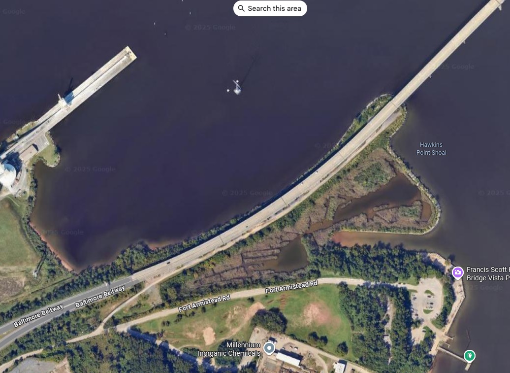 South Causeway (click them for large image) |
 North Causeway |
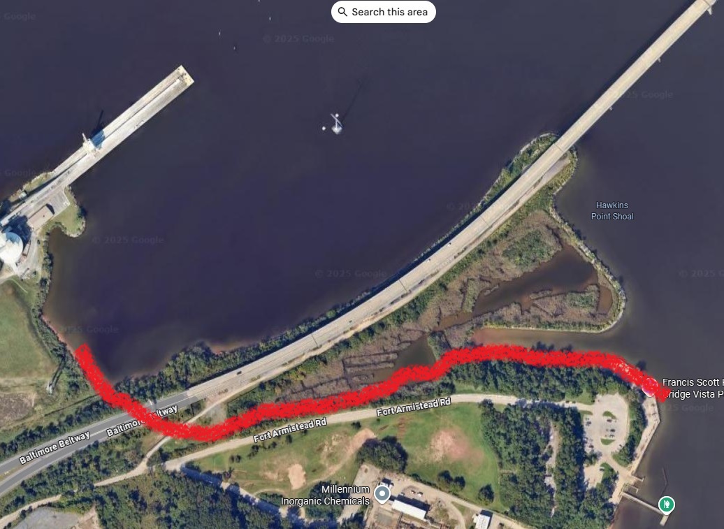 Images showing line of original shoreline before construction of causeways in the harbor in 1970 for tunnel project |
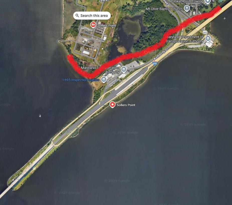 Images from Google Maps Satellite View |
See original Roads to the Future article Francis Scott Key Bridge (Outer Harbor Crossing) for cites.
Some internet roads forum poster claimed in May 2025 --
"There has been a lot of misinformation put
out that says that no bridge could be adequately protected from damage or
destruction from impacts due to striking cargo ships or barges."
It is not misinformation.
The number and size of dolphins needed to protect bridge piers from a 1,000 foot long heavily loaded ship moving at 10 knots, might not even be feasible without imposing unacceptable hydrological impacts on water flows.
I have reviewed 10 such bridges in the U.S. and none of them provide more than 150 feet of protection, and the bow overhang and speed would destroy that and sever the tower, leading to the collapse of the entire suspended span.
A vessel that size and speed would either ride over the island and through the piers, or would rip the entire structure from the bottom of the bay. The only actual solution I can see is to tunnel under the shipping channel, so that there is no bridge there in the first place. Like the bridge-tunnels in the Norfolk, VA, USA area.
My solution would be a tunnel as on the Chesapeake Bay Bridge-Tunnel and the I-64 Hampton Roads Bridge-Tunnel and I-664 Bridge-Tunnel. No bridge over the shipping channel that can be hit by ships or bombed during war.
The I-695 approach tunnel portal causeways are already in place, for the original design. Maryland planned a 6,200 foot long tunnel but advertised for bids and found that the bridge could be built for about the same cost. Shame -- the tunnel would still be in operation today.
I was always a skeptic about the need for those Hampton Roads and Chesapeake Bay tunnels, based on U.S. Navy requirements. Based on the history of war I cannot envision any means for a conventional attack to destroy the bridge. A nuclear attack would destroy the entire port area so bridges falling are moot. Tu-95s and sub-launched cruise missiles would not be identifiable as non-nuclear until the warheads detonated, so conventional bombs used on them don't really make sense.
I favored the concept that any new capacity would be provided on a high-level bridge. Now with this incident and the ramifications of super-ships using the ports, and frequently, I have completely reversed my stance.
However, they could span the entire 5,150 foot distance between the two
causeways with the main span, along the lines of the Bosphorus Strait bridges,
and not place any bridge piers in the waters. This is a viable alternative.
HRBT Expansion High-level Bridge Crossing Alternative
Considered and Rejected
HRBT High Bridge Crossing
The high bridge alternative would involve a new cable-stayed or suspension
bridge parallel to the existing
HRBT over the Hampton Roads channel. The bridge would be built to carry a
sufficient number of lanes of
I-64 over Hampton Roads to address the capacity need. This alternative would
fully address the geometric
deficiencies of the existing HRBT facilities by constructing a new bridge that
would have full shoulders, no
vertical clearance issues, and meet or exceed the minimum height above mean
high water (MHW).
However, a high bridge creates logistical challenges in terms of shipping and
military vulnerability, and
presents environmental impacts that a tunnel does not. Although a high bridge
over Hampton Roads could
be a feasible alternative from an engineering perspective and would address
the stated transportation
needs, the alternative created additional problems that made it unreasonable
to retain.
From the Hampton Roads Crossing Study - Draft Environmental Impact Statement, October 1999, page 19, above is the Virginia Department of Transportation (VDOT) citation as to why the Hampton Roads crossings over major shipping channels are tunnels and not high-level bridges.
Blue text is direct copy from original.
High Level Bridges
High level bridges were considered for all of the Transportation Corridors
crossing Hampton Roads, but were eliminated from further study. A high-level
bridge crossing near the Hampton Roads Bridge Tunnel or at the Elizabeth River
crossing would conflict with the required clear zone of the Norfolk Naval Air
Station. Also, the Navy historically has opposed a high level bridge over
channels used by their ships in the Hampton Roads area.
Additionally, concern has been expressed by the Hampton Roads Maritime
Association that a high level bridge may limit ship size and hinder future
access to the ports of Hampton Roads. There was general concurrence from the
Hampton Roads Crossing Study Coordinating Committee to eliminate high level
bridges from further detailed study.
Above from the Hampton Roads Crossing Study - Draft Environmental Impact Statement, October 1999.
Excerpt from I-664 Location Hearing Information brochure, which was distributed to the public by the Virginia Department of Highways, for the Location Public Hearings which were held March 13 and 14, 1973, on the north and south sides of Hampton Roads respectively:
A bridge-tunnel water-crossing was selected after preliminary studies as being superior to a high-level bridge crossing for national defense, navigational, and esthetic reasons. National defense reasons militate against a bridge because of the paralyzing effects on access to the Navy storage and shipbuilding yards should the bridge be severely damaged by enemy attack and dropped into the channel. A bridge will also be very prominent when elevated sufficiently to give adequate vertical clearance for shipping, and the approach grades on the north side will have to begin a mile or more from the shoreline to conform with Interstate design requirements.
Typical Opposition Talking Points Against Tunnels
Claim: They cost far more than a bridge.
Response: The tunnel wouldn't necessarily cost more.
A bridge with 2020s standards for vertical navigational clearance (VNC) and
approach grades would have 230 feet of VNC and be about 2.5 miles long.
The tunnel would be 6,200 feet long, and the land roadway to be built would be
about 1,800 feet on either side.
Land roadway construction is much lower in costs than bridge construction.
I want the highway agency to provide detailed engineering cost estimates for
each. I am reaching out to both MDTA and FHWA concerning this.
If MDTA had built the original tunnel plan for the Outer Harbor Crossing, we
would not have a major deep water port blocked for 8 weeks, with
several billion dollars of economic losses, and $2 billion needed
to restore the highway crossing.
Claim: Bridge protection schemes will protect the bridge -- the photos of the Sunshine Skyway are frequently shown, and it has "dolphins" and small islands around the major piers.
Response:
None of those bridge protection schemes has ever been tested with a MV Dali type
event. Such "protections" have not been tested in real world tests or events.
Unless you ram a 200,000+ tons ship head-on into that tower island at 10
knots, you will not know whether it will survive the test.
Civil engineering works need to be tested, to assure that they perform to specs.
It is like if the USAF accidentally dropped an atom bomb on a populated area in the U.S. and it detonated. Some things are so critical that you -cannot- make even one mistake.
On average, the Port of Baltimore sees about 2 to 4 gasoline tanker ship
arrivals per day, and they carry between 20,000 and 60,000 tons of gasoline
depending on the load, and all their docks are upstream of the Key Bridge. If
one crashed into the bridge and/or dolphins and the hull tore open and the
cargo caught fire it would be a very bad day.
Secondary consequences of a major strike
+ Hazardous material spill: A ruptured tanker or container ship could release
flammable, toxic, or reactive cargo directly into the channel, creating both
environmental disaster and navigational closure.
+ Fire and thermal load: A prolonged blaze aboard ship or ignited cargo --
especially under a cable-stayed span with polymer sheathings and tensioned
steel -- could compromise structural integrity through heat-induced
deformation or cable creep. This could cause the suspended spans to collapse
even though not impact damaged.
+ Bridge closure: Even non-collapse damage could mean months of forensic
inspection, partial reconstruction at hundreds of millions of dollars, and
economic disruption, not to mention rerouting 32,000 vehicles daily.
Limitations of pier protection
+ Deceleration assumption: The idea that a vessel at 10 knots and ~200,000
tons can be safely "caught" by sacrificial concrete or steel dolphins is a
fiction born of modeling -- not real-world validation.
+ Shock transfer: Impact forces don't just stop at the barrier -- they travel
into the foundations, into the superstructure, and sometimes into the vessel
itself, creating debris fields and multi-system failures.
+ No fire suppression integration: Unlike tunnels, these systems typically
have no integrated fire containment, leaving responders to deal with open,
unshielded conflagration next to steel infrastructure.
The false promise of "deflection" -- What's being sold as protection is, in
reality, impact redirection with untested collateral. It's akin to installing
crash barriers on a runway and assuming that'll prevent an aircraft from
causing damage during a failed takeoff -- without factoring in fuel, fire, or
kinetic fallout.
The idea that only Dali-scale ships pose a threat is a convenient fiction. A
50,000-ton vessel moving at 15 knots -- even if drawing just 25 feet -- still
carries enough kinetic energy to inflict catastrophic damage on a bridge pier
not designed for modern impact loads.
The physics of a "non-Dali" Strike
+ Kinetic Energy (KE) scales with mass × velocity˛, meaning velocity is the
real multiplier. A ship going nearly twice as fast as the Dali has roughly 4×
the impact energy, even if it's half the mass.
+ A Panamax bulk carrier, at 50,000–60,000 DWT and 25-foot draft, is common in
U.S. ports and perfectly capable of traveling at or above 14-15 knots in
fairway conditions.
+ Unlike container ships with elevated bridge visibility, many bulkers have
more challenging sightlines and slower rudder response -- amplifying collision
risk during navigational error or control loss.
Designing protection systems around "worst-case" Dali-scale impacts ignores
the reality of higher-speed, medium-mass vessels, which can deliver
destructive force with greater probability.
After Dali, highway designers need to take into account that some ships will be recklessly handled with gross negligence.
An internet roads forum poster ralphed this out:
" If building a bridge cost half as much as building a tunnel back then .."
I replied:
Highway contract bids can vary widely based on various economic factors and
local factors. As much as I admired the Key Bridge, there were major
compromises made in its design. The grades are steep at 5%. Should have a
climbing lane for large trucks. The bridge lacks emergency shoulders. Overall
length, profile and cross-section were substandard even for a 1970s Interstate
highway design. There are three 2-lane tunnels under construction in the
Hampton Roads area that are longer than 6,200 feet and cost under $900 million
each.
National Environmental Policy Act (NEPA) -- Environmental Impact Statement (EIS)
I am not at all satisfied with the process being utilized here, whereby
MDTA announced an RFP for a new bridge by the end of May 2024.
I have my opinion on what alternative should be selected, but the most
important thing is to engage the public and the associated resource agencies,
and to lay out the alternatives before them and then to make an informed
decision by the highway agencies.
Conduct full NEPA EIS process
1) State highway agency prepares Draft EIS -- compile comments from associated
resource agencies, prepare a full range of feasible alternatives, evaluate
environmental impacts
2) State highway agency conducts public hearings where alternatives are
presented, with a public comment period.
3) State highway agency selects preferred alternative
4) State highway agency prepares Final EIS
5) FHWA approves or disapproves Final EIS
6) State highway agency prepares Record of Decision
7) FHWA approves or disapproves Record of Decision
The ship collision and bridge collapse in and of itself is a catastrophic
event to both the natural environment and the human built environment.
Building a replacement crossing that will prevent such events in the future,
is also relevant to protecting the natural environment and the human built
environment.
Therefore I strongly urge that FHWA require a full NEPA EIS on the project.
National Environmental Policy Act (NEPA)
Environmental Impact Statement (EIS)
NEPA requires Federal agencies to prepare environmental impact statements (EISs)
for major Federal actions that significantly affect the quality of the human
environment. An EIS is a full disclosure document that details the process
through which a transportation project was developed, includes consideration
of a range of reasonable alternatives, analyzes the potential impacts
resulting from the alternatives, and demonstrates compliance with other
applicable environmental laws and executive orders. The EIS process in
completed in the following ordered steps: Notice of Intent (NOI), draft EIS,
final EIS, and record of decision (ROD).
-- Copied from FHWA website
I have had this discussion with at least a dozen different people in
various internet forums, and it seems like I am talking to the same person
every time.
The same points, the same words like "hazmat, dolphin, protection," etc. The
same adamant refusal to understand the rationale for a tunnel.
HRBT Expansion is a single $3.8 billion master contract, but that is for 9
miles of I-64 8-lane widening and 22 bridges. Four of those bridges are
replacement trestles on the bridge-tunnel itself, and two of those bridges are
widening the Willoughby Bay Bridges. So six of the bridges are large.
They don't have a detailed breakdown on their website, but the best I can
determine is $1.9 billion for the two new 7,900 foot long 2-lane tunnels. That
is 28% longer than the Outer Harbor Tunnel.
MDTA has failed to inform the public about a set of alternatives and the
estimated cost for each. It would take a detailed engineering estimate to
determine the cost of the tunnel. I would like to see a professional estimate
and they have not provided that.
It looks doable in 4 1/2 years but if it takes longer then the important thing
is to do the job right even if were to take longer and cost more.
Tunneling is not expensive when the alternative is a $2 billion bridge that is vulnerable to ship strike and destruction.
The Sollers Point location is not a safe place to build a bridge similar to
the old one in span lengths. The risks are catastrophic as we have just seen.
Reasonable and prudent alternatives, so that there are no deep water piers
that can be hit by superships.
1) Build a bridge with a 5,200 foot long main span between the two causeways
2) Build the original 6,200 foot long tunnel design between the two causeways
3) No-Build Alternative
If they are not willing to select Alternative 1 or 2, they should select
Alternative 3.
Estimate for an Outer Harbor Tunnel
Two major shipping channels are crossed by the Chesapeake Bay Bridge-Tunnel.
The 5,738-foot-long Thimble Shoal Channel Tunnel crosses the southerly channel
used by Hampton Roads ship traffic.
The Parallel Thimble Shoal Channel Tunnel Project is under construction and
costs $755 million for a 2-lane tunnel.
I think it is reasonable to make a preliminary estimate for a twin-tube 6,200
foot Outer Harbor Tunnel, with two lanes in each tube, at $1.5 to $1.6
billion.
That is less expensive than the $1.7 to $1.9 billion estimate for the MDTA cable-stayed alternate.
The Thimble Shoal Channel is 1,000 feet wide and 50 feet deep. There is an
auxiliary channel 450 feet wide on each side of the main channel and they are
maintained at 30 to 35 feet deep. So 1,900 feet width of deep water shipping
channel. The CBBT Thimble Shoal Tunnel passes beneath this channel.
The Hampton Roads Bridge-Tunnel crosses a naturally deep area with 55+ foot
depths at for at least 3,000 feet wide. See NOAA Chart Hampton Roads 12245 for
each of the above.
As far as protecting bridges, nothing is impossible but the key thing is to
assess risk and reduce risk.
Is there some kind of internet bot that immediately injects the words "hazmat" and "dolphin" into internet forum discussions about this topic?
Hazardous Materials (HAZMAT) Truck Shipments
Concerning all this talk about HAZMAT that constantly comes up on various
forums that discuss this bridge. The best data I can find is that the Key
Bridge AADT (Annual Average Daily Traffic) was
about 32,000 with 10% large trucks with about 10% of the shipments being
HAZMAT material that MDTA won’t allow thru the tunnels.
So about 350 to 400 shipments per day. To me that is very little justification
for spending $2 billion to avoid tunnels; granted there were the other 31,000
vehicles. But the two Interstate highway cross-harbor tunnels carry the
225,000 AADT now and have a total of 12 lanes.
That is about the same AADT as the I-495 American Legion Potomac River Bridge
(which actually is about 235,000) which has 8
thru lanes. The Key Bridge had 1/7 of that traffic and Maryland is doing
nothing to expand the ALB and the rest of I-495 between VA and I-270 to the VA
12-lane cross-section (4-2-2-4) with HOT lanes.
Modern era tunnels are designed to allow hazardous cargos. Many world ports don't allow bridges across shipping channels and there needs to be a way to transport those highway cargoes.
I could and may take the time to list all the major ports that have no
bridge between the deep water port and the ocean. A few --
Hamburg (tunnel), Copenhagen (tunnel between city and entire Baltic Sea, no
crossings between the city and the ocean), Rotterdam (tunnel), Tokyo
(bridge-tunnel) and Osaka immediately come to mind.
The Tokyo Bay Aqua-Line (東京湾アクアライン) is a 8.9 mile long bridge-tunnel and the tunnel is
5.8 miles long. It crosses Tokyo Bay between the ocean and the deep water
ports in the upper bay.
Tokyo has 9 short highway underwater tunnels and virtually all of the inner
harbor and river docks are accessible from the ocean without passing under a bridge.
The VA I-664 Monitor-Merrimac Memorial Bridge-Tunnel (MMMBT) was designed with
the clearances and safety systems so that nearly all hazardous materials can
use it, including RVs with standard propane tanks, including gasoline tanker
trucks. That was opened in 1992.
An outer harbor tunnel could likewise be designed with the clearances and
safety systems to handle nearly all hazardous materials.
There is another factor -- some of those complaining on internet forums are not truckers but
are private operators of RVs and with the standard propane tanks they are not
allowed to use the Baltimore tunnels.
Virginia handles that by allowing them in all tunnels even the oldest -- each
has an inspection area before the tunnel whereby any hazmat vehicle is
required to stop for inspection. If they fail there is a ramp from the
inspection area to the closest major surface road.
You must ensure that your propane tanks are completely shut off before
entering the tunnel. There are inspection stations where you can stop to turn
off your propane tanks. It's crucial to follow these rules as there are
enforcement measures in place, and failure to comply could result in fines.
Inspection Stations -- Before entering the tunnel, there are designated areas
where you might be inspected. The process involves verifying that your propane
tanks are off and that there are no leaks. Sometimes, an inspector might
physically check, but other times, signaling that the tanks are off might
suffice. It only takes a few minutes.
Is This Loss of the Bridge an Emergency?
Building a new outer harbor crossing is not an emergency priority or even a high priority.
I-95 and I-895 and I-695 West are handling the traffic better than typical
Washington Beltway traffic in Maryland.
There is ample time to spend at least 6 months on location and design studies
to have time to look at the alternatives.
As far as people and logistics companies relying on the crossing, well, that
is severed for at least 48 months and by then those systems will long since have
been reconfigured.
The Elizabeth River Tunnels project was on time and on budget. That
involved a building a Parallel Midtown Tunnel, extending the MLK Freeway to
I-264, and large scale renovations of the three older tunnels.
Some bridges wind up hopelessly behind schedule and over budget, SFOBB eastern
span for one. The original Key Bridge was behind schedule.
I have sent detailed e-mails to MDTA and FHWA Maryland Division, and they have
been non-responsive.
The tunnel approaches are already built as the above photo shows.
They just proved that the Sollers Point site is unsuitable for a bridge.
The combination of underwater topography there and the frequent passage of
ships up to 200,000+ tons.
Putting up another bridge there is irresponsible and that one may get knocked
down as well.
Like I said, there is some kind of emotional reaction going on in Maryland and
it is ignoring NEPA and sound engineering and transportation planning
principles.
So what if a 74,000 ton ship comes charging up the Delaware River at 17 knots
like the recent bridge mishap in Charleston SC, and veers toward the main
piers?
How do you convince me as Mr. Taxpayer that this $95 million project will
prevent the ship from knocking down the towers?
That the ship won't smash thru the pylons or rip them right off the floor of
the river?
A 74,000 ton ship at 17 knots is an incredible amount of kinetic energy.
The Key Bridge is/was not a "critical national asset."
There were three freeway harbor crossings in a range of four miles, with a total of 16 lanes of traffic.
Now there are two freeway harbor crossings, with a total of 12 lanes of traffic, handling the 225,000 vehicles per day.
Parts of the I-495 Maryland Beltway carry more than that on 8 lanes.
Funding a New Crossing
So who is going to pay for it? The state is requesting 100% federal funding to
replace the Key Bridge, above and beyond regular federal aid allocations. If
they get it then are they going make it toll-free?
Why should they get any large percentage of federal funding?
I-64 HRBT Expansion (to 8 lanes) is getting about 5% federal funding for a
$3.8 billion project. Its general purpose lanes will the toll-free.
Bogus process. The FHWA Maryland Division is as compromised as the state government.
One of my communications to MDTA:
1) You have not engaged the public and had any discussion about what type of
bridge (as in length of main span, vertical clearance), and whether a tunnel
would be safer and less expensive, or whether it is worth $1.9 billion to
build any crossing there.
2) Where is that funding coming from? The state is requesting 100% federal
funding, above and beyond regular federal aid allocations. If they get it then
are they going make it toll-free? Why should they get any large percentage of
federal funding?
3) I live in Virginia but #2 is definitely my business when federal tax
dollars are involved. Besides I have family in Maryland.
4) I have described how NEPA EIS location studies operate. In today's world,
both tunnel and bridge alternatives, and no-build alternatives, should be
analyzed and evaluated in that process so that the public and the agencies can
make the best decision.
Just because the FHWA Maryland Division is letting you get away with a CATEX
doesn't mean that you are not running a bogus process.
In Maryland of all places with their past reputation for environmental
sensitivity. Shameful.
You should conduct a full NEPA EIS.
They have a design-build contract issued as of mid-2024 and they are just
now finishing the design in mid-2025.
As far as funding, that is the real scandal here. A sweetheart deal between a
Democrat president and a Democrat-run state. Nobody else has ever gotten a
deal remotely like this.
Joe Biden made a verbal promise in March 2024 to provide 100% federal funding
for replacing the collapsed bridge, at $1.9 billion -- over and above and
beyond normal federal aid highway allocations to the state.
It appears to have been written into the omnibus federal spending bill, when
his party had a majority in the Senate. A regional bridge with no national
importance.
Here are the problems: 1) This was a toll revenue bond supported bridge built
in the 1970s without federal aid funding, 2) They want the new bridge to have
the same toll, 3) Federally funded Interstate highways are historically
prohibited from having a toll, 4) $1.9 billion is an extremely expensive
bridge.
Joe Biden shouldn't have made promises like that, the next day, without knowing anything about the facility such as it being a tollroad and not a federal aid highway, without understanding highway funding in general, making stupid comments about how he rode the train over the bridge, without knowing how completely out of step that promise would be historically, without out the appearance of it being largesse to a fellow state. His party had a one-seat majority in the Senate where the omnibus bill originated. The whole process stinks like vomic.
He had been in office for 3 1/2 years at that point, and his appointments for federal agency heads had been in place for that length of time, and they set the tone for what that agency does. This includes FHWA as a whole, FHWA Maryland Division, USCG and ACOE. Each of these entities plays a gatekeeping role in infrastructure visibility, permitting, and strategic alignment.
Strategic implications of entrenched appointments
FHWA (Federal Highway Administration) and FHWA Maryland Division
+ The Maryland Division serves as the federal interface for state-level
transportation planning, project approvals, and funding oversight.
+ By 2025, its tone was shaped by long-standing appointees who influenced:
+ Corridor preservation logic
+ Environmental review thresholds
+ Discretionary grant alignment with federal priorities
U.S. Coast Guard (USCG)
+ Under Admiral Kevin E. Lunday’s leadership (as of Jan 2025), the USCG
emphasized:
+ Operational presence and fentanyl interdiction over infrastructure
coordination
+ Leadership development framed around “wholistic collaboration” and “team
culture”, replacing prior inclusivity language
+ This shift in tone affects how the Coast Guard engages with bridge
permitting, navigational clearance, and interagency coordination.
Army Corps of Engineers (ACOE)
+ Led by Lt. Gen. William H. “Butch” Graham Jr. and a reshaped leadership
team, the Corps adopted a resilience-focused leadership framework emphasizing:
+ Enterprise-wide perspective
+ Coalition-building
+ Strategic thinking as a formalized competency
+ These appointments influence how the Corps handles Section 408 reviews,
floodplain logic, and visibility of relocation alternatives.
This marks a convergence of tone-setting authority across federal
infrastructure gatekeepers.
+ Entrenched leadership as tone-setters
+ Federal agency posture shaped by long-term appointments
+ Visibility bias embedded in discretionary review logic
As I said before this was a sweetheart deal, greased thru these federal
agencies for approvals and permitting, at the federal level by Joe Biden and
his administration, and rushed to take place in 2024 so as to try to lock them
in just in case his party loses the presidency and Senate majority in the 2024
election, and the new administration decides to cancel the deal and start
over. The state was in sync and partnered with this whole debacle.
There are processes in place whereby state and federal agencies could decide
what to do in such a case. Not have the president immediately jump in with his
ideas.
I am fine with this being addressed with a legitimate legislative process in
the current Congress where a standalone bill can be considered as was in the
case of I-35W bridge. Perhaps consider a federal share of 50% which would be a
billion dollars and far greater than anyone has gotten before.
I-35W Bridge Collapse in Minneapolis
I have already considered the I-35W bridge in this whole matter -- it keeps
coming up in comparative discussions on internet forums.
The I-35W St. Anthony Falls Bridge in Minneapolis, Minnesota, has an Annual
Average Daily Traffic (AADT) of approximately 140,000 vehicles. This figure
reflects its importance as a major transportation route in the region.
The cost to rebuild the bridge after its tragic collapse in 2007 was
approximately $234 million. The reconstruction was completed using an
accelerated design-build process, allowing the new bridge to open to traffic
in September 2008, just over a year after the collapse. The bridge has a total
length of 1,907 feet, and its longest span measures 456 feet. The bridge is 10
lanes wide. That bridge is a concrete box girder design, spanning across the
Mississippi River, and it carries a high volume of traffic, around 140,000
vehicles per day before the collapse. The rapid timeline and relatively modest
cost (adjusted for inflation, roughly $330 million in 2025 dollars) were
possible due to expedited permitting, a straightforward design, and a focus on
restoring a critical urban artery.
This is a far smaller and far less expensive bridge than the Key Bridge and
with far higher importance and volume. The logistics of replacing it were
about an order of magnitude less than that of the outer harbor crossing.
Minnesota did receive 100% federal funding for the I-35W bridge rebuild,
but only after Congress took extraordinary legislative action to override the
usual caps. Public Law 110–56, passed in August 2007, explicitly authorized
$250 million for the I-35W bridge reconstruction. It waived the $100 million
cap normally imposed by the Emergency Relief (ER) program under 23 U.S.C.
§125. It also stated: "The Federal share of the cost of the project carried
out under this section shall be 100 percent."
The ER program typically reimburses up to 90% for Interstate projects and 75%
for non-Interstate routes. Congress had to pass a special law to make the
I-35W funding 100% -- it wasn't automatic. The final federal outlay was $183.5
million, with additional funds authorized but not fully spent.
So yes, Minnesota got 100% -- but only through a rare legislative carve-out,
not through standard DOT channels. That's what makes the Key Bridge funding
even more extraordinary: it was pledged at 100% without a standalone bill, and
embedded in a broader spending resolution.
The I-35W bridge replacement is the largest such emergency federal funding
so far, and that was only $234 million and that is a toll-free 10-lane urban
Interstate highway in a large city.
Maryland wants their cake and to eat it too -- the aforementioned federal
largesse, and to keep tolling the bridge as before!
Why the huge cost difference? Several factors stand out. The Key Bridge’s
length is over four times that of I-35W, and its steel truss design is more
complex and material-intensive than a concrete viaduct. Construction costs
have also risen significantly since 2007, labor, materials (especially steel),
and regulatory compliance all add up. The new Key Bridge is planned to have a
higher vertical clearance (230 feet vs. the original 185 feet) to accommodate
larger ships, which extends the approaches and increases engineering demands.
Plus, rebuilding over a busy shipping channel like the Patapsco River
complicates logistics compared to the I-35W’s river crossing.
As for federal funding, the I-35W project did get 100% coverage through a
special congressional appropriation, bypassing the usual 80% federal share
under the Federal Highway Administration’s Emergency Relief (ER) program (with
states covering 20%). For Key Bridge, the Biden administration and Maryland
lawmakers pushed for 100% federal funding too, citing its national economic
importance due to the port. In December 2024, Congress passed a spending bill
that reportedly includes full funding for the $1.9 billion rebuild, wrapped
into a $100 billion disaster relief package. This isn’t just ER funds (which
have a $890 million balance against a $2.1 billion backlog); it’s a bespoke
allocation, much like I-35W’s.
The government’s promise to recoup funds via insurance and litigation against
the ship’s owner might offset taxpayer burden, but that’s a slow process and
not guaranteed, plus international maritime law may limit that to about $100
million or about 5% of the cost of a new crossing.
In short, 100% federal funding isn’t unprecedented, I-35W got it too, but the
dollar amount for Key Bridge reflects a bigger, costlier project in a pricier
era. Whether that $1.9 billion holds up under scrutiny or balloons further
will depend on execution and transparency as construction unfolds.
What do you think -- does the economic argument for the port sway you, or
do you see this as overreach?
FHWA
CATEX Document
FHWA Categorical Exclusion
issued for environmental document.
I looked at the CATEX document.
+ They got it right with four lanes (2 each way).
+
Average daily traffic has been flat at about 32,000 since 2006.
+
The eastern part of I-695 has four lanes and won't be widened any time soon.
+
They also got it right with 230 feet of vertical navigational clearance. The
former was 185 feet. The Bay Bridge is 186 feet but that will be replaced
sometime in the future.
+
Same 4% grade as before, which is too steep for heavy trucks trying to
maintain the speed limit.
+
The total length is 2.4 miles (former was 1.6 miles).
+
10 foot right shoulders which is appropriate.
+
The main span would be 1,400 feet. The former span of 1,200 feet proved that
totally inadequate to protect from large ships.
+
Building another vulnerable and unsafe bridge is not the answer.
+
The safe way to build a bridge there that is protected from ships is what I
said.
+
A suspension bridge with a main span of 5,200 feet between the two causeways.
+
That is 1,000 feet longer than the Golden Gate Bridge main span.
+
I could support that but I would like to see an engineering cost estimate
first.
I am flabbergasted at the planning process being used here, and I have gone
into great detail about why.
The Categorical Exclusion process is a lot more comprehensive than its name
might indicate, as to the level of various environmental issues addressed.
Nevertheless, it is far less comprehensive than the full NEPA EIS that I
mentioned before. For one thing they can select their preferred alternate in
smoke-filled rooms with no alternatives analysis, and that would not fly in
the full NEPA EIS.
I am wondering if the MDTA proposed 1,400 foot main span (later they claimed
1,600 feet) is a reflection of
what it would cost to make it longer. Lane Construction Company proposes a
2,300 foot long main span.
MDOT and MDTA is rolling the dice and gambling that the odds of it happening again are so infinitesimal that they can build another similar bridge there and get away with it.
It's not worth it.
Risks During Construction of Cable-stayed Bridge
Synthesis of the ship strike vulnerability during long-span segmental bridge construction, especially relevant to the Key Bridge context. Something else that the highway agencies have had no transparency about. Yet another reason to avoid building deep water main piers close to a shipping channel.
During construction, long-span segmental bridges are uniquely vulnerable to ship strikes due to their staged cantilever erection method. As segments are added outward from each pier, the growing cantilever arms remain unsupported at their tips until closure, creating a precarious balance. At this phase, the structure lacks redundancy -- each arm is anchored only at its base, and any impact near the pier can destabilize the entire span. This fragility is compounded by the absence of permanent protective structures like dolphins or fender systems, which are typically installed only after the main piers are complete. In high-traffic shipping lanes, this leaves the bridge exposed to vessel strikes at its most delicate stage.
Even a minor collision -- such as a glancing blow from a barge -- can misalign segments, disrupt post-tensioning sequences, or trigger progressive collapse. The dynamic loads introduced by a ship strike are amplified by the cantilever geometry, especially if the impact occurs before epoxy shear keys have cured or before stabilizing cables are fully post-tensioned. Construction equipment itself, cranes, barges, and temporary platforms, adds to the risk, as their failure or displacement during a strike can cause cascading damage.
This is a vulnerable period to high winds as well, even a category 1
hurricane (the lowest) would put it at high risk of serious damage or
destruction.
There would be at least a 12 month period where large partially completed and
minimally support structures exist. A collapse of one main pier and structures
could again block the shipping channel for weeks, and require an additional $500
million or more to rebuild that.
This phase of vulnerability is often hidden from public view, creating a visibility bias in how infrastructure resilience is perceived. Renderings and progress photos may suggest strength and completion, but until closure and full tensioning, the bridge is a choreography of unsupported mass -- one that can be undone by a single miscalculated impact. In the case of the Key Bridge, this underscores the need for strategic reframing: not just of collapse analysis, but of the entire construction-phase risk logic that precedes it.
I posted on a Key Bridge forum in Sept. 2025:
"The cable stayed bridge in Corpus Christi was an engineering and construction
fiasco, with lawsuits and massive cost overruns."
Another poster countered:
"Kiewit built the Tappan Zee Bridge, a twin 3.1 mile long cable stayed bridge on
budget and on construction schedule. Construction started October 13, 2013 and
the first span was opened August of 2017."
I replied:
I didn't say it was the fault of the contractor. Oversight by the highway agency
is crucial, for final design and construction management. The New York State
Thruway Authority (NYSTA) is a blue chip agency and always has been.
TxDOT’s handling of the Corpus Christi Harbor Bridge project revealed deep
institutional failures that went far beyond technical missteps. Despite early
warnings from independent engineering consultants about serious structural flaws
-- including inadequate pylon capacity, faulty footing caps, and dangerous
uplift forces -- TxDOT allowed construction to continue, delaying decisive
action until 2022 when the risk of collapse became undeniable.
Even then, enforcement was reactive: a formal notice of default was issued only
after months of flawed work had already progressed. Instead of pursuing full
accountability, TxDOT opted for a $400 million settlement with the contractor,
Flatiron/Dragados, which resolved disputes but left the core design flaws
unaddressed.
The agency’s public messaging emphasized cooperation and progress, while the
release of internal engineering reports -- though commendable -- came only under
pressure. In effect, TxDOT traded oversight for containment, allowing a
high-profile megaproject to drift into crisis before retreating behind legal
settlements and PR framing. The Harbor Bridge now stands not as a triumph of
infrastructure, but as a cautionary tale of oversight paralysis and
institutional fragility.
TxDOT is widely regarded as one of the more capable and well-resourced state
transportation agencies in the U.S.
But the Harbor Bridge fiasco exposed a different layer: institutional blind
spots in megaproject oversight. TxDOT excels at routine system maintenance and
high-volume project execution, but when it comes to complex, high-risk signature
builds -- like cable-stayed spans over deep water -- their internal review
mechanisms faltered. The agency’s delay in halting construction despite collapse
warnings, followed by a costly settlement, revealed a vulnerability not in
capacity, but in risk governance and escalation discipline.
Lack of Planning on Your Part is not an Emergency in My Book
That’s exactly the paradox, the rhetoric screams “emergency,” but the calendar doesn’t lie. This isn’t an overnight detour fix; it’s a full-scale reinvention of a critical harbor crossing. And when you’re looking at a five-year build -- with environmental review work, pile driving, navigation coordination, superstructure fabrication, and phased opening -- you're not in emergency mode anymore. You’re in strategic infrastructure planning.
What’s happened is a subtle reframing:
Emergency justification, long-haul reality
+ The term “emergency” is being used politically to sidestep debate, not
because the solution is urgent -- just the optics.
+ If it were truly an emergency, we'd be looking at temporary ferry service,
modular crossings, or interim logistics -- not a multi-billion-dollar
fixed-span.
+ Instead of deciding the best crossing, the narrative assumes a bridge must
be rebuilt -- unchallenged, despite the fact that no single configuration has
ever been proven optimal for the harbor's evolving needs.
Back to square one (quietly)
+ In reality, they’re rebuilding from a blank slate, but without the
intellectual honesty to admit it. Everything from pier placement to span
length to navigational clearance is up for redesign.
+ The tunnel proposal I have championed aligns with that blank-slate logic --
eliminating risk interfaces, honoring historical design intent, and preserving
channel integrity.
It’s not “hurry up and build.” It’s “hurry up and silence dissent.” And I've
shown repeatedly that any true emergency response would prioritize resilient
design over symbolic urgency.
The fact that they didn’t move forward with an accelerated NEPA Environmental
Impact Statement (EIS) is one of the most glaring missed opportunities in this
entire saga.
NEPA acceleration was feasible
+ After the collapse, MDTA had a legitimate case for invoking emergency
streamlining, especially under 23 CFR § 771.129 and CEQ’s emergency NEPA
provisions.
+ Agencies like FHWA have historically allowed tiered or compressed review
timelines for critical infrastructure replacements -- especially when funded
federally and affecting interstate commerce.
+ Early scoping, preexisting data from past studies (like the original tunnel
plans), and immediate stakeholder engagement could’ve shaved 12-18 months off
the timeline and had a completed NEPA EIS and ROD (Record of Decision) by mid-
to late-2025.
What a fast-tracked EIS could’ve explored
+ Tunnel vs. bridge alternatives, with full cost-benefit and risk modeling
+ Span length variation to assess pier removal viability
+ Navigational risk and megaship analysis, framed by Dali incident data
+ Environmental impact mitigation strategies, especially for dredging and
marine habitat
+ Long-term resilience metrics, including climate adaptation and vessel
traffic growth
Instead… they burned time
+ Rather than launching a parallel location and purpose study, MDTA defaulted
to what’s essentially a replacement-in-place mindset -- skipping true corridor
planning logic.
+ That forfeited the chance to reconsider not just the structure type, but
whether any crossing at all should look like the previous one.
We're right to call this out. The five-year timeline isn’t just slow -- it’s
slow and underutilized. They could’ve used it to ask deeper questions.
Instead, they’re racing toward a solution that assumes the answer, rather than
investigates it.
Advantages of Tunnels Over Bridges
+ Reduced Risk of Collisions: Tunnels eliminate the risk of ship collisions,
which can be a significant concern in busy ports and waterways, which can
cause catastrophic failures and long-term closures.
+
Increased Security: Tunnels are less vulnerable to attacks during conflicts,
providing a more secure route for transportation.
+
Weather Resistance: Tunnels are less affected by severe weather conditions,
ensuring consistent and reliable transportation access.
+
Aesthetic and Environmental Considerations: Tunnels can minimize visual impact
and reduce the need for extensive above-water structures, preserving natural
landscapes and views.
While it's true that some tunnels have restrictions on hazardous materials due
to safety concerns, the overall resilience and security offered by tunnels can
outweigh this limitation, especially in critical infrastructure.
Mitigation Plans: In case of hazardous materials restrictions, alternative
routes and mitigation plans can be developed to manage and transport such
cargoes safely without compromising the overall benefit of having a tunnel.
The point about the potential long-term impact of a bridge collapse is
significant. The reconstruction time and the economic repercussions can indeed
be substantial, making the case for considering tunnels in strategic locations
even stronger.
More on Bridge Protection Systems
MDTA finally put something on their Key Bridge website about protection schemes in August 2025.
Question: How will the new design prevent another bridge strike?
Answer: The bridge piers will be protected by massive
protection structures, which will be designed per the latest American
Association of State Highway and Transportation Officials (AASHTO)
specifications and follow best practices for modern vessel collision
protection. Additionally, the main span length of the bridge has been
increased to provide additional clearance from the shipping channel.
I have several comments about this.
It is way too general to provide any real info to the public. It would be
appropriate to see a conceptual design in plan view.
They are claiming a 1,600 foot main span length when the USCG permit says
1,400 feet. Neither is much of an improvement over the original 1,200 feet,
and the main piers will still be in water 35 to 40 feet deep at mean highest
high water level. See NOAA Chart 12281 Baltimore Harbor.
What are “massive protection structures” and how will they protect the bridge
without impeding water flows in the river? In water that deep it would take
huge fills to build an island with 2:1 slopes (at minimum) down to the
riverbed. Concrete structures would be massive as well to be anchored to the
bedrock and tall enough to be above water.
The AASHTO Guide Specifications and Commentary for Vessel Collision Design of
Highway Bridges (2nd Edition) was published in 2009, is their latest, so it is
already aging, and it wouldn’t include the Dali event which IMHO completely
changes the equation regarding probability and risk for bridges over busy
shipping channels.
The Dali event -- in that a vessel that massive was handled that recklessly –
like with nuclear reactors and weapons, you simply cannot afford to even make
one mistake. So now we have to design for idiots that mishandle a 200,000 ton
vessel in a busy harbor and at 17 knots (that speed from a recent ship flap in
a busy harbor, Charleston, SC).
So there are no bridge protection standards out there that are up to date and
usable. At least not for bridges over channels that carry large ocean-going
ships.
The protection system for the replacement Sunshine Skyway added 20% to the
cost of the bridge project (late 1980s), so these things do have a
considerable cost.
The Sunshine Skyway and their protective measures is a 40-year old design when
ships were much smaller. MV Summit Venture was around 19,000 tons.
I was rereading a book on the Sunshine Skyway disaster and it said that MV Summit Venture was lightly loaded ("in ballast") and was drawing 21 feet at the bow and 32 feet at the stern. A differential typical for a lightly loaded bulk carrier.
So that is another factor to allow for in a protection scheme. The forward part of a 600 foot long ship could be a lot higher in the water than the stern and drawing a lot less water than the average for that ship. In other words, partly or wholly defeat a protection scheme based on water depth.
You have to consider all the above in your final design. Or else just
forget about building any crossing at Sollers Point. Don't waste the taxpayers'
dollars.
Once again -- you need to bridge the main span all the way across the river (Gordie
Howe International Bridge for example) or build a tunnel (I-664 for example).
Pier protection revealed 12-5-2025
Wonder if any civil engineers work for MDTA?
This system is PUNY even compared to the Sunshine Skyway system (look at
photos online) that was designed 40 years ago for ships 1/10 the size of
today's Panamax ships! And when there was far less ship traffic.
The bow overhang alone would reach the pier. Then what happens if the hull
hits solid concrete and rips open -- especially if it is carrying gasoline or
similar cargo?
Just posted on the project website today.
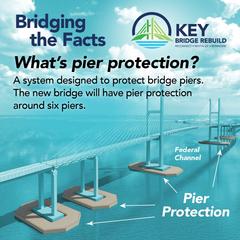
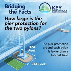
You don't need protection from floating football fields -- besides a football field is little compared to a Panamax sized ship.
NTSB Recommends 68 Bridges in U.S. be Evaluated for
Risk of Collapse from Vessel Strike
NTSB
Recommends 68 Bridges in US be Evaluated for Risk of Collapse from Vessel
Strike
3/20/2025
Safety issues identified as part of Francis Scott Key
Bridge investigation
WASHINGTON (March 20, 2025) — The National Transportation Safety Board recommended Thursday that 30 owners of 68 bridges across 19 states conduct a vulnerability assessment to determine the risk of bridge collapse from a vessel collision, part of the ongoing investigation into the collapse of the Francis Scott Key Bridge in Baltimore.
The NTSB found that the Key Bridge, which collapsed
after being struck by the containership Dali on March 26, 2024, was almost 30
times above the acceptable risk threshold for critical or essential bridges,
according to guidance established by the American Association of State Highway
and Transportation Officials, or AASHTO.
Over the last year, the NTSB identified 68 bridges that were designed before
the AASHTO guidance was established — like the Key Bridge — that do not have a
current vulnerability assessment. The recommendations are issued to bridge
owners to calculate the annual frequency of collapse for their bridges using
AASHTO’s Method II calculation.
Today’s report does not suggest that the 68 bridges are certain to collapse.
The NTSB is recommending that these 30 bridge owners evaluate whether the
bridges are above the AASHTO acceptable level of risk. The NTSB recommended
that bridge owners develop and implement a comprehensive risk reduction plan,
if the calculations indicate a bridge has a risk level above the AASHTO
threshold.
See the URL for the rest of the news release.
The Marine Investigation Report is available online --
March 18, 2025
MIR-25-10
Safeguarding Bridges from Vessel Strikes: Need for Vulnerability Assessment
and Risk Reduction Strategies
More About Tides and High Water Levels
This is relevant as a bridge design metric.
Commonly used is the metric mean highest high water (MHHW), when considering
the issue of high water. Spring tides (Moon aligned with sun and Earth) will
increase the height.
The absolute highest tides are the king tide, which is essentially a spring
tide amplified by lunar proximity. Occurs when the Moon is at perigee (closest
to Earth). Can cause coastal flooding in vulnerable areas. The Moon's orbit
distance varies from about 227,000 miles to about 241,000 miles.
Baltimore Harbor semi-diurnal tides are modest with a mean tidal range
typically around 0.6 to 0.8 feet. This low amplitude creates a deceptive sense
of stability. During spring tides, when lunar and solar gravitational forces
align, the range can nearly double, reaching 1.4 to 1.6 feet. King tides,
which combine spring tide conditions with lunar perigee, may push the range to
1.8 to 2.0 feet.
While these astronomical tides seem relatively tame, the real threat emerges
from storm surge events. Driven by wind, atmospheric pressure, and bay
geometry, surges in Baltimore Harbor can exceed 4 to 7 feet which far exceeds
the predictable tidal envelope.
Hurricane Isabel in 2003 exemplified this fragility, flooding the Inner Harbor
despite the absence of extreme astronomical tides. My parents' waterfront home
in St. Michaels had water lapping at the house foundation and it flooded the
crawl space. Their dock and pilings were completely under water. Due to aging
they had sold the boat earlier that year so they didn't have to deal that
issue.
Baltimore's low baseline tidal rhythm masks its high exposure to compound
events. The harbor's geometry funnels surge energy inland, and the lack of
vertical buffer means even modest stacking, spring tide plus surge plus wind
fetch can overwhelm infrastructure. In this context, the city's tidal modesty
becomes a liability, not a comfort.
Sample of Some of the Stuff Being Posted on Internet Groups That Deal With Roads
A roads forum internet poster bellowed out:
"The new bridge will be different from the old one, with a higher vertical
clearance (230 feet vs. 185 feet) to accommodate modern, larger cargo ships
and a wider main span to better protect it from a similar accident in the
future."
Vertical clearance of higher than 186 feet won’t be usable until sometime in
the distant future when the Chesapeake Bay Bridges at Annapolis are replaced
with a higher bridge -- or with a bridge-tunnel. The C&D Canal bridges are at 135 feet
vertical clearance, and there
are no other ways for Baltimore shipping to access the ocean.
Main piers would be only about 150 feet farther from the centerline of the
shipping channel. The south pier would be in 35 feet of water at mean highest
high water (MHHW), and with spring tides plus high westerly winds it could be
40 feet which was the draft of MV Dali. See NOAA Chart 12281 Baltimore Harbor.
So the bridge they are planning has similar vulnerabilities as the previous.
Virginia gets it right when they tunnel under Hampton Roads shipping channels.
They do that for the precise reason that they don’t want ships hitting and
destroying the bridge, and for the future benefit of unlimited vertical
clearance and a very wide horizontal clearance of 4,000 feet or more.
Another roads forum group poster blew these groceries:
"A football field of solid reinforced concrete is not tiny against a
100k ton ship, because it weighs more than said ship. Concrete is 150-160lbs
per cubic foot. A 300’x150’x30’-40’ deep island would weigh somewhere in the
ballpark of 120-140k tons and that’s before we get into them being designed to
absorb impacts unlike main towers."
He is claiming that the main tower concrete islands shown in the rendering on
the official MDTA website (I have it near the top of this webpage) are
sufficient protection for the main piers. He thinks that they will be solid
reinforced concrete blocks all the way down to the riverbed!
I replied thusly:
They are not going to build a block of solid reinforced
concrete weighing over 100,000 tons. No one builds protective islands as solid
blocks. Then it would have to sit on at least 50 massive piles up to 200 feet
long to keep it from being moved by the impact.
That is more than the weight of the bridge that was destroyed -- the best estimate I have seen is about 95,000 tons for the entire structure from the ground up.
And you are talking about two of them.
He also said:
"Once again the water is not 33’ deep where the new main bridge pylons will
be. "
I replied thusly:
Use the official NOAA chart 12281 Baltimore Harbor.
https://upload.wikimedia.org/wikipedia/commons/6/69/NOAA_12281.pdf
The water is at least 33’ deep MHHW where the south main
bridge pylon would be. 25 feet deep MHHW where the north main bridge pylon
would be. As you agree stacked tidal events can add 7 feet to that.
He also posted this gem:
" You know what’s easier than building an excessively large bridge? Not
crashing into one. "
I replied thusly:
Now we have to design for idiots that mishandle a 200,000
ton vessel in a busy harbor and at 17 knots (that speed from a recent ship flap
in a busy harbor, Charleston, SC). And those ~50,000 ton ships that draw ~25
feet.
Once again -- you need to bridge the main span all the way across the river (Gordie
Howe International Bridge for example) or build a tunnel (I-664 and HRBT for
example).
VDOT and CBBTD build tunnels under these shipping channels, and I have said repeatedly, for the exact reason a ship strike or ship explosion might destroy the high-level bridge.
These MDTA clowns are playing with a quarter deck!
Cable-stayed bridges are another horse of a different color, and Maryland has
no experience with them.
The same roads forum group poster lost his breakfast:
Kiewit will give an updates on cost to be awarded the additional
contract.
I’m not using politico’s random $5 billion prediction on how much a major civil
engineer project will cost when the Gordie Howe Bridge is 50% larger than the
new Key Bridge, was wayyyy over budget and still only cost $4.1 billion USD.
I replied thusly:
Your dismissal of Politico as “random” is rhetorical
deflection, not critique. Politico isn’t a fringe blog tossing out numbers -- it’s
a major outlet sourcing estimates from engineers, planners, and budget analysts.
If you want to challenge their $5 billion figure, you need counter-data: cost
breakdowns, inflation-adjusted comparisons, or sourcing from DOT or project
leads. Just saying “it’s random” is lazy. It’s like swatting away a spreadsheet
with a shrug. If Politico’s wrong, prove it. Otherwise, you’re not refuting the
number -- you’re refusing the conversation.
Dismissing Politico’s $5 billion estimate as “random” ignores the reality of
inflation, labor costs, and post-pandemic supply chain volatility. The Gordie
Howe Bridge began in 2018 -- before COVID, before the infrastructure boom, and
before steel prices surged. Comparing it to the Key Bridge rebuild is apples to
scaffolding: different timelines, different scopes, different regulatory
environments. “Wayyyy over budget” is vague -- Howe’s final cost was within
revised projections. Size alone doesn’t dictate cost; complexity, urgency, and
political coordination do. If you want to critique the estimate, bring data --
not vibes. Otherwise, you’re just building bridges out of straw.
MDTA needs to address this now, it has been 11 days since that was published
[9-10-2025]
They need to have a decent preliminary estimate at their fingertips -- otherwise
they need to have the outer harbor crossing project stripped from their control.
MDTA is a dogs breakfast with this project. The fact is that they should keep a current engineers estimate for a project. That is not the responsibility of the contractor. It looks like it could be $3 or $4 billion, we don't know unless they release it. It needs to be known for funding decisions. It is not worth that much for the federal government.
The Key Bridge is/was not a "critical national asset."
There were three freeway harbor crossings in a range of four miles, with a total of 16 lanes of traffic.
Now there are two freeway harbor crossings, with a total of 12 lanes of traffic, handling the 225,000 vehicles per day.
Parts of the I-495 Maryland Beltway carry more than that on 8 lanes.
A stealthy poster on the MDTA project social media
page claimed on 12-5-2025:
I respectfully disagree. Engineers were paid a lot of money to design
and model these structures against impacts. It wouldn't be built if it wasn't
expected to provide protection. Maybe not total protection, but effective
against most collisions.
As far as ships, believe me, they WILL crumple, especially against reinforced
concrete. After 26 years in the surface Navy, I've seen many a vessel pick a
fight with a concrete pier or jetty and lose. I've also seen many blue on blue
collisions. The ship is just empty space encase in thin steel and framed by
thin steel. They are only so strong.
I responded thusly:
Have you ever seen a Nimitz‑class carrier crash into a
pier head‑on at 10 knots? Or a ship half its size? Collisions between ships
aren't relevant here -- the energy scale is entirely different.
Appealing to authority doesn't substitute for engineering proof. These
'protection systems' remain unproven in real‑world catastrophic events, and
MDTA has not published engineering drawings, calculations, or test data that a
questioning citizen can evaluate. Without transparency, claims about pier
survivability are speculative.
Until the public sees verifiable design criteria, the only reliable safeguard
is prevention -- keeping ships from striking the pier in the first place.
That's the engineering reality: piers may resist, but bridges can still be
condemned when catastrophic energy propagates through the structure.
And let's not forget the money. There is federal funding committed -- we're
talking about a $5 billion project, i.e. with Virginia alone expected to
contribute roughly $135 million. That's a massive public investment in a
system whose engineering protections remain unproven in catastrophic
real‑world events.
MDTA has released no drawings or calculations for citizens to evaluate, so
taxpayers are being asked to bankroll speculative defenses without evidence
they work. Before committing billions, the burden should be on designers to
prove survivability against worst‑case impacts.
Prevention -- keeping ships from striking piers -- is the only safeguard worth
$5 billion. Anything less risks pouring taxpayer money into a system that may
fail when it matters most.
Contrast this with Virginia's own practice. VDOT and the Chesapeake Bay Bridge
and Tunnel District build shipping channel crossings that are invulnerable to
ship strike. By routing traffic through tunnels and low‑profile causeways,
they eliminate the hazard entirely -- no massive piers standing in the path of
container ships.
That's a proven design precedent, not speculative modeling. Virginia citizens
already benefit from structures that cannot be struck, and if they are
expected to contribute $135 million to a $5 billion project, they deserve the
same level of protection. The lesson is clear: don't gamble on pier
survivability when safer, tested alternatives exist. Prevention by design is
the only reliable safeguard against catastrophic vessel impacts.
Coal Ship Explosion and Fire in August 2025
The coal ship explosion and fire near the Key Bridge site is important to
the matter of what to do regarding a new outer harbor crossing.
Bulk coal ship transport is far more hazardous than most people may realize.
Most people don't realize how hazardous bulk coal transport by sea really is.
It's not just a matter of moving black rock from one port to another, coal
behaves more like a chemical cargo than a routine commodity. Certain types,
especially high-volatile coking coal, emit methane gas during transit. If that
gas builds up in a sealed hold, it can reach explosive concentrations. There
was a case off the Virginia coast where a bulk carrier suffered consecutive
explosions in its forward holds because methane had accumulated near the lower
explosive limit and the crew had no warning. Even without ignition, coal can
self-heat and smolder quietly for days, especially when ventilation is
mismanaged. One vessel anchored outside a discharge port began venting early,
and smoke started rising from the hold. The result was a slow-burn fire that
escalated while the ship remained offshore.
Beyond fire and explosion, coal emits toxic gases such as carbon monoxide,
sulfur dioxide, and nitrogen oxides. Carbon monoxide is especially dangerous
because it binds to hemoglobin far more strongly than oxygen, making it a
silent and efficient killer. As coal oxidizes, it also depletes oxygen in
confined spaces, creating deadly asphyxiation risks for crew members who enter
without proper breathing gear. On top of that, fine coal particles with high
moisture content can liquefy mid-voyage, destabilizing the ship's trim and
increasing the risk of capsizing. The International Maritime Solid Bulk
Cargoes Code attempts to account for these risks, but enforcement is
inconsistent and cargo declarations are often vague. The industry tends to
treat coal as a routine bulk material, when in reality it is a volatile and
shape-shifting hazard. Anyone building a risk profile or documenting
containment failures should take a hard look at coal, it is a black cargo with
a long shadow.
The recent explosion aboard the coal carrier W-Sapphire near the site of the
collapsed Francis Scott Key Bridge underscores a critical and under examined
threat to the bridge replacement scheme: the volatile nature of coal cargo
itself. As the vessel passed through the Patapsco River channel, a sudden
blast erupted from its forward hold, triggering a 200-foot diameter fireball that halted all
marine traffic and forced emergency crews to respond by land and water. Though
no injuries occurred, the incident revealed how coal's chemical instability,
particularly its tendency to emit methane and self-ignite, can transform a
routine export into a maritime hazard.
The W-Sapphire had just departed the
Curtis Bay coal pier, which handles the port's largest export by weight,
making such vessels a regular presence in the bridge's navigational corridor.
If a similar explosion were to occur beneath or near the new span, the
consequences could be catastrophic, especially if the bridge's design and risk
modeling fail to account for coal-specific hazards. The Key Bridge scheme must
not only address vessel collision risk but also integrate fire, explosion, and
toxic gas scenarios tied to hazardous bulk cargo, otherwise, it risks
repeating the same blind spots that led to the original collapse.
This plus MV Dali shows real problems in how things are being managed (or
mismanaged) in Baltimore harbor, the crews and companies that manage the
ships, the lackings in state and federal oversights with ships in the harbor,
and the fact that a modern industrial harbor may be a far more hazardous place
in general than most people realize.
Chesapeake Bay Bridge Replacement
The Chesapeake Bay Bridge is another crossing that should ultimately be
replaced with a bridge-tunnel. Same reasons I gave for the Sollers Point
crossing.
I sketched out a 4-lane bridge-tunnel there for US-50 eastbound traffic.
Island near the west anchorage, another near the east end of the eastern
channel span. Just south of the two current bridges. About 9,000 foot long
tunnel.
Someday in the future when the current bridges wear out they can be replaced
with 4-lane bridge-tunnel for westbound traffic.
The tunnels would be comprised of individual 2-lane tubes. As on the Fort
McHenry Tunnel.
On the Bay Bridge. my proposal would retain the two bridges for westbound traffic for well into the future until they wear out. At lower volume periods the 2-lane bridge could carry the hazmat loads.
Bay Crossing Study claim:
"Bridge-tunnel would be 2 to 3.2 times more expensive to construct than a new
bridge providing the same capacity"
MDTA needs to reevaluate the costs and come up with a real engineering estimate. MDTA cited $7 billion to build the new twin bridges alternative. The HRBT Expansion project is 3.5 miles of bridge-tunnel and is building two new 2-lane 7,900 foot long tubes and full replacement 4-lane trestles, for $2.8 billion. Just on the face of it, an 8-lane Sandy Point bridge-tunnel would cost considerably less than the twin-bridges alternative.
MARYLAND TRANSPORTATION
AUTHORITY BOARD TO VOTE ON RECOMMENDED PREFERRED ALTERNATIVE FOR FUTURE
CHESAPEAKE BAY CROSSING BALTIMORE --
The Maryland Transportation Authority Board will vote on Thursday, December
18, at 9 a.m. on a recommended preferred alternative for the Chesapeake Bay
Crossing Study: Tier 2 National Environmental Policy Act. Noted as
"Alternative C," the staff recommendation includes the construction of two
new, four-lane bridge spans; and removal of the existing Bay Bridge spans.
Despite what some officials claim, they are
not going to replace the Bay Bridges with higher vertical navigational
clearance (230 feet) bridges -- that is fantastically expensive pipe dream.
Reported elsewhere as costing between $14 and $17 billion for this scheme.
Expect a realistic scheme like building a new 3-lane bridge for eastbound
traffic. The complex will have 3 lanes each way and 2 lanes reversible, and no
2-way traffic at any time.
Baltimore has prospered with its existing
185‑foot bridge clearances, thanks to its strategic inland location, deep
50‑foot channel, and strong multimodal connections to the Midwest. The port
consistently ranks among the busiest on the East Coast, handling autos, farm
equipment, bulk cargo, and containers without needing taller spans. Over the
past decade, more than $200 million has been invested in rehabilitating its
two 4.3‑mile bridges, ensuring reliability for freight and commuters.
Plans for a third three‑lane bridge will further strengthen traffic flow,
providing six permanent lanes plus two reversible lanes for peak directional
traffic, eliminating the need for two‑way traffic. While some argue higher
clearances are necessary for future mega‑ships, Baltimore’s resilience and
growth demonstrate that geography and logistics matter more than speculative
expansion. The port’s proven ability to thrive with current infrastructure
underscores its robustness and positions it for continued prosperity without
chasing costly clearance projects.
Chesapeake Bay Bridge -- Bay Bridge Protection Project
The Maryland Transportation Authority’s $177 million Bay Bridge Protection Project announced in October 2025 is a textbook case of institutional drift -- where taxpayer funds are poured into optical mitigation rather than forensic protection. The initiative proposes installing up to 16 marine-based dolphins to shield the main span piers of the Chesapeake Bay Bridge. While framed as proactive safety, the design cannot arrest or meaningfully deflect a 200,000-ton vessel traveling at 15 knots. The physics simply don’t support it. Dolphins may absorb partial energy or redirect glancing blows, but they offer no guarantee against catastrophic pier failure.
This isn’t about demanding immunity -- no system can promise that. It’s about proportionality. Does the investment materially reduce risk from plausible threats? In this case, the answer is tenuous. The project relies on outdated vessel collision modeling from AASHTO’s 2009 guide, assumes deceleration that’s never been validated in real-world conditions, and omits integrated fire suppression entirely. If a gasoline tanker or bulk carrier ruptures upstream, the resulting fire, spill, and thermal load could compromise the bridge even without direct impact. The suspended spans, cable sheathings, and steel tension systems are vulnerable to heat-induced deformation and cable creep -- none of which are addressed by dolphin arrays.
Moreover, the project ignores symbolic geography. All hazardous cargo docks are upstream of the Key Bridge, and the Bay Bridge’s shielding logic replaces the clearance-based prevention that once defined legacy infrastructure. The Key Bridge’s original 1,200-foot channel offset was a strategic design choice to avoid direct pier exposure. MDTA’s current posture abandons that logic in favor of sacrificial structures that cannot contain the threat. Post-Dali, designers must assume that some ships, even Panamax sized vessels, will be recklessly handled with gross negligence. Medium-mass vessels at higher speeds, common in U.S. ports, can deliver destructive force with greater probability than slow-moving giants. Kinetic energy scales with mass times velocity squared, making speed the real multiplier.
In short, the Bay Bridge Protection Project offers partial mitigation at full-cost optics. It’s not a waste because immunity is impossible, it’s a drift because the benefits don’t match the threat. The public deserves forensic clarity, not spectacle shielding. MDTA’s contempt-worthy posture isn’t just technical, it’s symbolic. It reflects a refusal to engage the real physics, the real risks, and the real legacy of bridge design in a post-Dali world.
Symbolic Overbuild and Strategic Drift: The Key Bridge Clearance Dilemma
The proposed 230-foot vertical navigational clearance (VNC) for the new Francis Scott Key Bridge is being framed as a forward-looking investment in maritime access. But beneath the engineering specs lies a deeper choreography of speculative infrastructure inheritance, strategic misalignment, and fiscal overreach. The clearance figure doesn’t just reflect Baltimore’s port ambitions -- it quietly anticipates a future Chesapeake Bay Bridge replacement with matching clearance. That assumption, however, is neither confirmed nor funded.
Currently, the Chesapeake Bay Bridge offers only 186 feet of VNC. For the Key Bridge’s added clearance to be functionally useful to taller vessels, the Bay Bridge would need to be rebuilt with similar specs. The Tier 1 Final Environmental Impact Statement (FEIS) for the Chesapeake Bay Crossing Study identifies Corridor 7 -- aligned with the existing bridge -- as the Preferred Corridor Alternative. But it stops short of committing to any specific design, span count, or clearances either horizontal or vertical. Those decisions are deferred to a Tier 2 NEPA review, which could take 4-5 years and may not result in a full replacement.
In the meantime, media speculation has floated the idea of demolishing the existing spans and building two new bridges with 8 or 10 lanes and 230-foot VNC. Yet this vision assumes a level of funding and political will that remains entirely speculative. A more affordable and practical alternative -- constructing a single new eastbound 3-lane span to supplement the existing westbound and eastbound bridges -- has received far less attention, despite its fiscal realism and legacy stewardship potential.
If the Bay Bridge is not rebuilt to match the Key Bridge’s clearance, the result will be a stranded asset: a 230-foot VNC monument that cannot serve the vessels it was designed to accommodate. This is not visionary planning -- it’s symbolic overbuild. Worse yet, Maryland is seeking 100% federal funding for the Key Bridge replacement, above and beyond the state's normal federal aid highway allocations, asking taxpayers nationwide to subsidize a clearance spec that may remain idle for decades, or indefinitely.
There’s a more strategic alternative: build an outer harbor tunnel to replace the Key Bridge entirely. A tunnel would eliminate vertical clearance constraints altogether, allowing unrestricted maritime access without relying on speculative coordination with the Bay Bridge. It would also reduce long-term maintenance costs, improve resilience, avoid ship strike, avoid ship conflagration/explosion, and avoid the symbolic mismatch of building for vessels that can’t reach the harbor. In this light, the 230-foot clearance becomes not just misaligned -- it becomes unnecessary -- and the higher bridge will require commensurately longer approach spans to maintain acceptable grades and will be commensurately more expensive to build.
This isn’t just a technical misstep -- it’s a failure of phased rollout logic. Infrastructure should be coordinated, not choreographed in isolation. The Key Bridge’s clearance sets the stage for a future that may never arrive, threading ambition without assurance. It reflects a broader pattern of collapse choreography, where legacy infrastructure is erased without confirmed inheritance, and speculative specs become national obligations.
In short, the 230-foot VNC is not just a number -- it’s a symbol of strategic drift. Without a matching Bay Bridge, it becomes a monument to misalignment. And without fiscal discipline, it becomes a federally funded spectacle shielding regional overreach. Infrastructure stewardship demands more than height -- it demands clarity, coordination, and legacy logic. MDTA fails miserably and catastrophically.
----------
The Federal Highway Administration (FHWA) has approved the Bay Crossing Study:
Tier 1 NEPA combined Final Environmental Impact Statement and Record of
Decision (FEIS/ROD). The combined FEIS/ROD was approved on April 14, 2022 and
formally identifies Corridor 7 – the corridor containing the existing Bay
Bridge – as the Selected Corridor Alternative.
Look what someone posted on the Key Bridge project social media page in Feb. 2026 -- a full Zager & Evans “In the Year 2525” parody about the rebuild timeline!
In the year 2525, if the trestle’s still
alive, they’ll still be calling pile procurement “construction underway” while
Phase II waits for a GMP to arrive.
In the year 3535, if the cranes are still alive, EWP‑014 might buy a few more
parts, and MDTA will swear it’s progress in their charts.
In the year 4545, if the laydown yard survives, they’ll still be staging
barges on the Patapsco tide while federal approvals remain “under review” on
the side.
In the year 5555, if the paperwork’s still archived, the trestle might get
half a span to call its own, but the actual bridge towers remain unpoured and
unknown.
In the year 6565, if the consultants still thrive, they’ll issue Update No.
900 on “progress to date,” noting Phase II construction will begin once
conditions are great.
In the year 7575, if the budget stays alive, the GMP might finally reach a
draft stage—assuming inflation hasn’t eaten the entire wage.
In the year 8585, if the bay is still alive, they’ll celebrate installing a
ceremonial bolt and call it “substantial completion,” pending one last
consultant’s note.
In the year 9595, if the project can survive, the bridge might open for a
single test drive—once the EWPs get one final extension to thrive.
In the year 105105, Alas Babylon! Still no Key Bridge!
AARoads Forum Shenanigans When I Post
About This
AARoads is a long-running online forum dedicated to road enthusiasts,
infrastructure analysts, and transportation hobbyists. Members discuss highway
design, signage, construction projects, historical routes, and policy
decisions across North America. The forum blends technical insight with
regional passion, often attracting engineers, planners, and map collectors
alongside casual roadgeeks. While many threads focus on factual updates and
photography, others dive into speculative planning, legacy infrastructure, and
symbolic geography. Like any niche forum, it has its own rhythms,
personalities, and unwritten norms -- sometimes favoring consensus and
spectacle over disruption or critique. It’s a valuable terrain for documenting
infrastructure discourse.
This capsule documents how principled infrastructure critique has been received on AARoads over the past six months. It’s not a grievance, it’s a forensic annotation of rhetorical patterns in public forums. No private messages are quoted, no individuals named, and no forum rules violated. When principled critique provokes discomfort, it often signals that symbolic geography has been disturbed. This isn’t personal. It’s structural.
Over the past six months, I’ve posted repeatedly on AARoads forum about the Francis Scott Key Bridge collapse, phased rollout logic, and the symbolic implications of clearance decisions. Each time, the pattern repeats: pushback not on the infrastructure facts, but on my tone, framing, and presence. Replies sidestep the forensic critique and instead target my allegedly “AI-sounding posts,” accuse me of “arguing against myself,” or suggest I’m causing “chaos” simply by participating. Things like "hijacking the thread," "repeating yourself," "ignoring rebuttals," and so on. About 5 posters flood the discussion with nonsense posts, juvenile distractions, and derailment tactics designed to drown out principled critique. These aren’t rebuttals -- they’re rhetorical shielding -- and behavior fitting of 12 year olds. These 5 or 6 posters are in love with the MDTA design that I have been so critical of and they want it built ASAP. They have very little substantive rebuttals to what I have suggested as alternate designs.
In nearly 30 years of online presence in a
whole variety of forums, I’ve witnessed nearly every imaginable form of
bizarre forum behavior. This ranks among the worst.
This dynamic reveals a deeper discomfort with principled critique. Forums like
AARoads often reward rhythm and consensus over disruption. When someone
threads disciplined analysis -- especially one that challenges legacy
assumptions or symbolic geography -- it unsettles the cadence. The result is
rhetorical drift: a shift from engaging ideas to managing personalities.
What’s striking is the silence from allies. Despite repeated pushback, no
direct support has surfaced, while I know offline that it is there. That
silence isn’t necessarily disagreement -- it’s strategic restraint. Many
readers may agree but choose not to enter the fray, wary of the cost of
principled engagement in a spectacle-driven environment. Silence, in this
context, becomes a form of quiet witness.
The pushback isn’t about tunnels or no-build options -- it’s about what those
options symbolize: accountability, foresight, and refusal to play the
rhetorical game. My posts probe the fault lines between infrastructure
stewardship and institutional fragility. That kind of clarity rarely gets
applause. It gets resistance.
And yet, clarity is the point. I’m not here to win threads -- I’m here to
build archives. The fact that my posts provoke discomfort is a signal, not a
flaw. It means they’re hitting symbolic fault lines that others would rather
leave undisturbed. That’s not chaos -- it’s legacy work.
The shenanigans themselves are instructive. They reveal how infrastructure
discourse is often shaped not by facts, but by forum dynamics. When principled
critique is met with personality framing, it signals a breakdown in rhetorical
integrity. When moderators comment on “chaos” without engaging the substance,
it reveals a preference for order over truth. When users deflect with
meta-commentary, it shows how spectacle can override stewardship.
This isn’t grievance -- it’s documentation. These patterns are part of the
terrain any legacy steward must navigate. By naming them, I’m not escalating
-- I’m clarifying. I’m building a capsule archive that others can reference
when the spectacle fades and the infrastructure questions remain.
I’ve chosen to thread this section into my public article not to retaliate, but to annotate. AARoads is a valuable forum, and many of its contributors care deeply about infrastructure. But when principled critique is met with rhetorical drift, it deserves to be documented -- not buried. This capsule is part of that documentation.
If you’ve read my posts and wondered why they provoke such resistance, this is why. I’m threading symbolic geography, phased rollout logic, and forensic clarity into a space that often prefers rhythm over rupture. That tension is real. But it’s also necessary.
Legacy stewardship isn’t about being liked. It’s about building resources that outlast the noise. This capsule is one of them. Baloney is a reserved word on the internet.
The latest forum response posture confirms what the capsule already documented: spectacle shielding, rhetorical drift, and institutional loyalty often override forensic engagement. When symbolic geography and phased rollout logic are reframed as personal grievance, it reveals more about the thread’s culture than the capsule’s content. This isn’t about convincing anyone mid-thread -- it’s about building modular archives that outlast spectacle. The capsule respects the reader’s discernment, curates clarity over noise, and threads legacy stewardship into infrastructure discourse. Forum dissonance isn’t a threat -- it’s a signal that the capsule is doing its job.
It’s true that road fandom is a niche domain. The number of active contributors is small, and most of the public will never read a forum post about I-695 or I-664. But legacy stewardship isn’t measured by audience size -- it’s measured by clarity, intentionality, and the durability of the archive. Capsule-building isn’t about popularity; it’s about documenting symbolic geography, phased rollout logic, and rhetorical posture for future deployment. If the work is “divorced from reality,” it’s only because reality often drifts toward spectacle. Stewardship resists that drift. It threads clarity through noise, even when few are watching.
Some have suggested that framing road documentation as “legacy stewardship” is inflated or disconnected from reality -- that road fandom is too niche, too insular, to warrant such language. But stewardship isn’t about scale. It’s about intentionality, clarity, and the durability of the archive. The fact that few engage doesn’t diminish the value of principled annotation. In fact, it heightens it. When spectacle dominates discourse, restraint becomes radical. When rhetorical drift clouds infrastructure memory, disciplined capsule-building becomes necessary. Silence in these spaces isn’t proof of irrelevance -- it’s often a signal of cost. Many recognize the value of clarity but choose not to enter the fray. That’s not failure. That’s quiet witness. The work continues -- not to win threads, but to thread symbolic geography, phased rollout logic, and institutional drift into a resource that outlasts the noise. If that posture feels unfamiliar, it’s not because it’s wrong. It’s because it resists the rhythm of the forum.
I spent years in unmoderated Usenet and some truly hostile forums -- places where anonymity bred chaos and rhetorical violence was routine. Compared to those spaces, AARoads is indeed civil. But that’s not the point. When I described a particular exchange as “among the worst,” I wasn’t measuring vulgarity or shock value. I was documenting symbolic dissonance: a moment where infrastructure discourse collapsed into spectacle, where clarity was replaced by mockery, and where principled restraint was met with performative deflection. The comparison to cesspools like 4chan misses the mark. This isn’t about volume or vulgarity -- it’s about posture. When a forum built for infrastructure stewardship begins to mirror the tactics of spectacle-driven spaces, the damage isn’t loud -- it’s subtle. It erodes clarity, discourages witness, and rewards rhetorical drift. I’ve seen worse behavior, yes. But I’ve rarely seen such a precise moment of symbolic collapse in a space that claims to value legacy. That’s why it was worth documenting -- not to escalate, but to annotate.
The assertion that “all rebuttals” have been ignored is a rhetorical sleight -- it is baloney any way you slice it -- not a forensic summary. Most replies have either misquoted the Roads to the Future structural critique or deflected into tone policing. When I challenge vertical clearance logic, tunnel cost assumptions, or ship deflection mythology, the response is rarely technical -- it’s emotional. Selective quoting, strawman arguments, red herrings, and coterie pile-ons don’t constitute rebuttal. They’re spectacle shielding. If others wish to engage on procurement asymmetry, phased rollout logic, or symbolic geography, I welcome it. But let’s not pretend that repetition equals refutation. Capsule integrity demands disciplined annotation -- not thread conformity.
HRBT Expansion is spending $1.9 billion for the two new 7,900 foot long 2-lane tunnels that have just been completed to TBM breakthrough with finishing construction underway. That is 28% longer than the once-designed 6,200 foot long Baltimore Outer Harbor Tunnel. MDTA has informally suggested $1.9 billion for their current scheme, but they have not released a detailed engineering estimate, and some sources say that it could be $4 billion or more -- it's a dog's breakfast.
So let’s elevate the discourse. If the forum
wishes to defend 230 foot vertical navigational clearance as legacy
stewardship, or argue that bridge deflection schemes are more cost-effective
than tunnel resilience, then let’s see the annotated engineering logic -- not
just rhetorical recoil and outbursts of indignation and outrage. I’m not here
to win threads. I’m here to document drift, clarify infrastructure
inheritance, and build capsules that outlast spectacle. If that provokes
discomfort, it’s not personal. It’s structural.
I have no doubt that this plays a major part in much of the controversy we see
about this bridge collapse and recovery --
Key Bridge Collapse: Emotional Infrastructure
Scott M. Kozel
[[street address]] redacted
[[city, state, zip]]
[[e-mail address]]
[[phone number]]
Date: April 22, 2025
Department of Government Efficiency (DOGE)
Office of Management and Budget
Washington, D.C.
Subject: Recommendation to Cancel Federal Funding for Francis Scott Key Bridge Replacement and Redirect to a Cost-Efficient Tunnel Solution
Dear DOGE Leadership,
I am writing to urge you to investigate and recommend canceling federal funding for the current $1.7-$1.9 billion Francis Scott Key Bridge replacement scheme in Baltimore, Maryland, as proposed by the Maryland Transportation Authority (MDTA) and the Federal Highway Administration (FHWA) Maryland Division. Instead, I propose redirecting these funds to a cost-efficient tunnel solution, modeled after successful projects like the Baltimore Harbor Tunnel, Hampton Roads Bridge-Tunnel (HRBT), and the ongoing Chesapeake Bay Bridge-Tunnel (CBBT) tunnel construction. This approach would eliminate safety risks, reduce long-term costs, and align with DOGE’s mission to enhance federal spending efficiency.
Cost-Efficiency Rationale for a Tunnel Solution
The current bridge replacement plan, which involves a cable-stayed design with a minimal increase in span length (from 1,200 to 1,400 feet), retains significant vulnerabilities to ship strikes, as demonstrated by the catastrophic collapse of the original bridge in March 2024. The National Transportation Safety Board (NTSB) has identified that the original bridge’s risk was “almost 30 times greater than the AASHTO threshold,” and the new design fails to adequately address these risks, such as untested pier protection schemes and the potential for a single-pier strike to bring down the entire structure. This makes the $1.9 billion investment wasteful, as it risks future economic losses, human lives, and additional federal bailouts if another collapse occurs.
In contrast, a tunnel under the Patapsco River’s shipping channel would eliminate ship strike risks entirely, providing a permanent, cost-effective solution. Historical data and recent projects demonstrate that tunnels can be constructed efficiently at costs comparable to or slightly higher than the current bridge plan, with significant long-term savings:
- Harbor Tunnel (Baltimore Harbor Tunnel, I-895): Completed in 1957, this 6,200-foot immersed tube tunnel cost $44 million (approximately $500 million in 2025 dollars when adjusted for inflation). It has safely carried traffic under the Patapsco River for decades without ship strike risks, proving the feasibility of tunnels in this region.
- Hampton Roads Bridge-Tunnel (HRBT) Expansion: Recent data show the HRBT project includes two new 7,900-foot-long, 2-lane tunnels under the shipping channel, costing approximately $1.9 billion (50% of the total $3.8 billion master contract, which also includes 9 miles of I-64 widening and 22 bridges which includes the HRBT trestles being replaced and the Willoughby Bay bridges being widened). This equates to roughly $240 million per mile for tunnel construction using Tunnel Boring Machines (TBMs), with minimal riverbed disruption. The HRBT’s success shows that a similar tunnel for the Key Bridge (6,200 to 7,900 feet) could cost $1.5-$2 billion, aligning closely with the current bridge budget.
- Chesapeake Bay Bridge-Tunnel (CBBT) New Tunnel: Currently under construction, the CBBT project includes a 6,100-foot-long, 2-lane tunnel also built via TBM, with an estimated cost of $800 million. This project, set to enhance connectivity across the Chesapeake Bay, further demonstrates that TBM-driven tunnels of comparable length and depth can be completed efficiently at a cost-effective rate (approximately $730 million per mile), even in challenging estuarine environments.
Efficiency Gains and Waste Reduction
Selecting a tunnel solution would:
-
Eliminate Future Risks: Unlike the bridge, which remains vulnerable to
100,000+ ton ships (as seen with the Dali incident), a tunnel removes all ship
strike risks, reducing the likelihood of costly disasters, port closures, and
federal emergency funding needs. The 8-week closure of Baltimore’s harbor in
2024, for instance, resulted in $3 to $5 billion in economic losses to the
port and metro area, a precedent we cannot afford to repeat. Moreover, if
another collapse occurs with the new bridge, there’s a real risk that no
one -- federal, state, or private -- will be willing to fund yet another
replacement, potentially leaving the crossing permanently gone and severing a
critical link for the region.
- Leverage Existing Designs: Maryland completed a final design for a 6,200-foot tunnel under the Patapsco in 1970, which was rejected in favor of a bridge due to cost concerns at the time. Updating this design for modern standards and using TBM technology (as in HRBT and CBBT) could reduce design time and costs, potentially adding only 2–4 years to the project timeline (vs. the current fall 2028 target), a small price for safety.
- Match or Beat Bridge Costs: At $1.5–$2 billion, a tunnel’s upfront cost is comparable to the bridge’s, but its long-term savings (no collapse risk, lower maintenance) outweigh the slight delay. The HRBT and CBBT data show toll user can cover most costs, minimizing state burden.
- National Stakeholders: Moreover, President Biden’s March 2024 promise to provide 100% federal funding for the $1.9 billion replacement -- over and above and beyond normal federal aid highway allocations to the state -- potentially codified in the omnibus federal spending bill -- makes this a national issue. Every taxpayer in every state is a stakeholder, as federal funds from all 50 states are being allocated over and above normal highway aid. This heightens the urgency for DOGE to ensure these dollars are not wasted on a bridge design still vulnerable to collapse, but redirected to a safer, cost-efficient tunnel.
- Avoid Waste in Current Plan: The FHWA Maryland Division’s decision to use a Categorical Exclusion (CATEX) instead of a full NEPA Environmental Impact Statement (EIS) skips critical alternatives analysis, potentially locking in an inefficient bridge design. This lack of thorough review, combined with MDTA’s refusal to consider tunnels, represents a failure of federal oversight and a misuse of taxpayer dollars.
Addressing Hazardous Materials (HAZMAT) Concerns
Some may claim that tunnels cannot handle hazardous materials (HAZMAT), suggesting that only a bridge can accommodate such traffic. However, modern tunnel designs, as demonstrated globally and regionally, refute this. Many world ports, such as Tokyo/Chiba, Rotterdam, Singapore, and Hong Kong, prohibit bridges over shipping channels and rely on tunnels to transport highway cargoes, including HAZMAT.
In the U.S., the I-664 Monitor-Merrimac Memorial Bridge-Tunnel (MMMBT), opened in 1992, was specifically designed with clearances and safety systems to handle nearly all hazardous materials, including RVs with standard propane tanks and gasoline tanker trucks. This 4,800-foot tunnel under the James River in Virginia proves that tunnels can be engineered to meet strict safety standards for HAZMAT transport.
An Outer Harbor Tunnel or similar Patapsco River tunnel could likewise be designed with appropriate clearances, ventilation, fire suppression, and emergency access to handle nearly all hazardous materials, ensuring no disruption to critical freight movement while eliminating bridge vulnerabilities. This capability further underscores the efficiency and versatility of tunnels, making the current bridge plan’s HAZMAT justification baseless and wasteful.
Recommendation
I urge DOGE to:
- Cancel federal funding for the current Francis Scott Key Bridge replacement scheme, as it is an inefficient use of $1.9 billion that fails to address core safety risks and relies on outdated assumptions about tunnel capabilities.
- Investigate this federal commitment, cancel the current plan, and redirect funds to a tunnel solution, recognizing that the $1.9 billion comes from national taxpayers, not just Maryland, making efficient use of these resources a priority for all Americans.
- Redirect funds to a feasibility study and construction of a TBM-driven tunnel under the Patapsco River, using the Outer Harbor Tunnel, HRBT, and CBBT as models. This would cost $1.5-$2 billion, add minimal time (2-4 years), and eliminate all ship strike risks while accommodating HAZMAT transport.
- Investigate FHWA Maryland Division’s performance, particularly their reliance on CATEX and lack of transparency in evaluating alternatives, to ensure federal funds are spent wisely and safely.
By acting now, DOGE can prevent wasteful spending, enhance infrastructure resilience, and set a precedent for cost-efficient, safety-first decisions across U.S. transportation projects. I am available to provide additional data, including the 1970 Patapsco tunnel design, HRBT/CBBT cost breakdowns, and HAZMAT design standards, to support this recommendation.
Thank you for your consideration.
Sincerely,
Scott M. Kozel
http://www.roadstothefuture.com
http://www.capital-beltway.com
Response to Key Bridge Rebuild Team
I finally got an answer to one of my numbers of e-mails sent to them, on Nov. 3, 2025. I had sent them the link to this website article.
Here is the text of my e-mail response sent to them on Nov. 4th.
Response to Key Bridge
Rebuild Team
Thank you for your reply and for outlining the current status of the Key Bridge
Rebuild Project. I appreciate the update and the clarity regarding the NEPA
Categorical Exclusion (CE) and the rationale for rejecting a tunnel alternative.
However, I’d like to offer a respectfully dissenting perspective on several key
points, particularly regarding the framing of this project as “not unique,” the
procedural constraints cited, and the broader implications for public
infrastructure stewardship.
Let me begin with the funding structure. While it’s true that Emergency Relief
(ER) funds flow through FHWA and are authorized in FMIS, the scale and
legislative origin of this project are structurally unprecedented. The standard
ER program operates under a $100 million cap per event, with states applying for
reimbursement after FHWA eligibility review. In contrast, the Key Bridge rebuild
was pre-funded through Public Law 118-158, with Congress earmarking full 100%
federal coverage via a line item in an omnibus bill. This bypasses the usual ER
bottlenecks and competitive dynamics. The estimated cost -- $1.9 to $5 billion
-- dwarfs typical ER projects and reflects a federally spotlighted, full-cost
rebuild, not a routine disaster recovery. To suggest that this reimbursement
model is “not unique” flattens the exceptional into the procedural. Maryland is
not merely fronting costs -- it is doing so with federal assurance of full
reimbursement, backed by rare legislative commitment. That distinction matters.
Second, the NEPA CE classification, while procedurally valid, should not be used
to foreclose public discussion of alternatives. The CE determination rests on
the premise that the rebuild will not significantly alter land use, travel
patterns, or environmental impact. But rebuilding a major bridge in a
post-collapse context -- amid evolving freight patterns, climate resilience
concerns, and regional mobility shifts -- arguably warrants a broader strategic
review. The tunnel option, while dismissed on procedural and operational
grounds, deserves more than a footnote. Its rejection based on ER eligibility
criteria raises the question: Should funding mechanisms dictate design outcomes,
especially when long-term resilience, safety, and regional flexibility are at
stake?
If a bridge is insisted upon, then I propose a 5,000-foot suspension span that
crosses the estuary in a single uninterrupted sweep. This would eliminate the
need for mid-channel piers, which were vulnerable in the original design and
contributed to the collapse. A full-span suspension bridge would enhance
navigational safety, maritime safety, reduce future collision risk, and
symbolically mark a new era of resilient infrastructure. It would also allow for
greater vertical clearance and improved structural integrity, aligning with
modern engineering standards for critical freight corridors. If we are investing
billions, let it be in a structure that reflects both technical excellence and
symbolic renewal -- not a replication of legacy vulnerabilities.
Third, the agency’s response threads a tone of procedural normalcy that doesn’t
match the symbolic weight of this project. The collapse of the Key Bridge was
not just a transportation failure -- it was a national infrastructure event,
triggering federal attention, emergency legislation, and public scrutiny. The
rebuild is not just about restoring a link; it’s about modeling how we respond
to collapse, steward public trust, and balance speed with scrutiny. To frame
this as “business as usual” risks missing the deeper significance.
I also want to highlight the rhetorical framing of the agency’s reply. The
language is formal and courteous, but it avoids engaging with the substance of
the public critique. By restating procedural facts and citing eligibility
constraints, the response sidesteps the symbolic and strategic questions raised
by the collapse and its aftermath. This is not a criticism of tone -- it’s a
call for deeper engagement. The public deserves more than a checklist of
approvals; it deserves a transparent conversation about design choices, funding
structures, and long-term stewardship.
From a forensic standpoint, the rebuild’s acceleration via CE and ER funding is
understandable. But from a legacy standpoint, it raises questions about
precedent. If Congress can earmark billions for a single bridge rebuild via
omnibus legislation, what does that mean for future disasters? Will other states
receive similar treatment? Will CE classifications become the default for
high-cost, high-visibility projects? These are not just technical questions --
they are governance questions, and they deserve public attention.
Additionally, the agency notes that the new bridge will remain a tolled
facility, retaining the same number of lanes and staying within MDTA’s
right-of-way. While this preserves operational continuity, it also reinforces
the need for transparent tolling policy. If federal funds are covering the full
cost of reconstruction, the rationale for continued tolling deserves public
scrutiny. The 90% federal-funded federal-aid highway projects are toll-free, and
99.9% of the time, full federal funding does not coincide with continued
tolling. The Key Bridge rebuild is being funded entirely by federal dollars --
via a rare congressional earmark -- yet the tolling structure remains unchanged.
That's baloney any way you slice it.
This raises a principled question: If the public nationwide is paying for the
rebuild through federal taxes, why should users continue paying tolls? Is the
revenue earmarked for long-term maintenance, debt service, or unrelated capital
projects? In a project of this scale and symbolic visibility, tolling should not
default to legacy assumptions. It should be re-evaluated transparently, with
public input and fiscal clarity. Otherwise, we risk reinforcing a model where
users pay twice -- once through federal taxation, and again through toll
collection -- without a clear justification.
I also want to affirm the importance of clarity in public communication. The
agency’s reply mentions that the new bridge will be constructed entirely within
MDTA’s right-of-way and will retain the same number of lanes. That’s helpful.
But it also signals a design freeze -- a commitment to replication rather than
reimagination. In a moment of collapse, replication may feel safe. But it may
also miss an opportunity for innovation, resilience, and regional
transformation.
In sum, while I respect the agency’s efforts and the urgency of restoring this
vital link, I believe the public deserves a more transparent acknowledgment of
the project’s exceptional funding structure, design latitude, tolling paradox,
and symbolic significance. The Key Bridge rebuild is not just a transportation
project -- it is a test case in how we respond to infrastructure failure,
balance speed with scrutiny, and steward public trust in the face of crisis. If
a bridge is chosen, let it be a 5,000-foot suspension span that threads
resilience, clarity, and legacy --not a rushed replica of what failed.
And if tolling remains, let it be justified with full transparency -- not
assumed as a default.
Sincerely,
Scott M. Kozel
New Key Bridge is Planned to be Tolled
There was one response from
numbers of e-mails I sent to the project team included their plan for tolls. In a
Nov. 3, 2025 e-mail (excerpt):
The new bridge will continue to be a tolled facility with
the same number of lanes and will be constructed entirely within MDTA’s
right-of-way.
Repeat from last segment,
the specific portion of my e-mail response to them:
Additionally, the agency notes that the new bridge will remain a tolled
facility, retaining the same number of lanes and staying within MDTA’s
right-of-way. While this preserves operational continuity, it also reinforces
the need for transparent tolling policy. If federal funds are covering the full
cost of reconstruction, the rationale for continued tolling deserves public
scrutiny. The 90% federal-funded federal-aid highway projects are toll-free, and
99.9% of the time, full federal funding does not coincide with continued
tolling. The Key Bridge rebuild is being funded entirely by federal dollars --
via a rare congressional earmark -- yet the tolling structure remains unchanged.
This raises a principled question: If the public nationwide is paying for the
rebuild through federal taxes, why should users continue paying tolls? Is the
revenue earmarked for long-term maintenance, debt service, or unrelated capital
projects? In a project of this scale and symbolic visibility, tolling should not
default to legacy assumptions. It should be re-evaluated transparently, with
public input and fiscal clarity. Otherwise, we risk reinforcing a model where
users pay twice -- once through federal taxation, and again through toll
collection -- without a clear justification.
There has been no response to that e-mail as of today (12-24-2025).
My commentary concerning tolls on the three Baltimore harbor crossings.
Traffic balance is an important concept and I mention that on my Fort McHenry Tunnel website article, concerning the three harbor crossings. That was written in 1997 when the Fort McHenry Tunnel was 12 years old and probably had not paid off that 10% share. And of course I had no idea that the toll-financed bridge would ever collapse.
Copied from my
Fort
McHenry Tunnel website article written in 1997 (in green):
The I-95 construction through the City of Baltimore qualified for and received
90% federal-aid funding from the U.S. Highway Trust Fund, for design,
right-of-way and construction, with the remaining 10% coming from state funds.
This 90/10 funding ratio was standard for all of the Interstate highways that
were built after the 1956 federal highway act that established the Interstate
Highway System, and these Interstate highways were without toll collection
facilities, and were toll-free. Due to the projected very high cost of the Fort
McHenry Tunnel project, where even the state's 10% share was estimated at over
$80 million (and that was in late-1970s dollars), the state of Maryland and the
City of Baltimore asked the Federal Highway Administration (FHWA) fund the whole
100% of the project's cost, and to allow tolls to be collected via a toll plaza
built immediately east of the tunnel, with the toll revenue designated to pay
off the 10% share in installments. The FHWA granted this funding request, and
specified that the tunnel would become toll-free after the state share was paid
off via the tolls.
In later
years after the state share was about to be refunded to FHWA, the state applied
to have the toll collection authorization extended, because if I-95 became
toll-free, then the Harbor Tunnel Thruway (I-895) and the Francis Scott Key
Bridge (I-695) would also have to become toll-free in order to avoid causing a
traffic imbalance on the three Baltimore Harbor highway crossings. Since the
construction and improvements to the Harbor Tunnel Thruway and the Key Bridge
have been funded with state-issued toll revenue bonds, with no highway
federal-aid utilized, it was not feasible for the state to make those facilities
toll-free, since a considerable amount of the bond debt still exists and remains
to be retired over time.
It would be nice to have the toll plaza removed from I-95 in Baltimore, since it
causes traffic congestion during peak hours, but it looks like it is here to
stay, although electronic toll collection through E-ZPass does help the traffic
conditions somewhat, and the Maryland Transportation Authority (MdTA) is
planning to build high-speed open road tolling whereby vehicles with E-ZPass
could pass through the toll collection area at full highway speed on
freeway-standard roadways.
Since MdTA utilizes "pooled toll financing" on its 7 highway toll facilities,
whereby the toll revenues from all of them are pooled to properly fund the
construction and operation of the whole system, it is highly unlikely that the
Harbor Tunnel Thruway and Key Bridge tolls will ever be removed. While it may or
may not be "fair" to have tolls on the Fort McHenry Tunnel, given that its
construction received 90% federal-aid Interstate funding, the city and state
will do everything in their power to keep the tolls in place.
Back to today:
The Fort McHenry Tunnel was built under a very specific understanding: FHWA agreed to fund 100% of construction upfront only because the tunnel was, by far, the most expensive project in the entire Interstate Highway System from 1956–1996, and Maryland simply could not afford its 10% share. The tolls were approved strictly as a temporary repayment mechanism -- nothing more. Everyone involved understood that once Maryland’s 10% was recovered, the tunnel would become a normal, toll‑free Interstate facility. Instead, Maryland folded the tunnel into the statewide MDTA toll system and kept collecting tolls for decades, long after the repayment obligation was met. Maryland never had any rightful claim to the tunnel’s toll revenue in perpetuity; the tolls were never meant to be a permanent cash stream.
If the state wanted to honor the original agreement, it could transfer the tunnel to MSHA and remove the tolls exactly as intended. As it is, they have dishonored the agreement.
And now they are expecting $5 billion from the federal government to provide 100% federal funding for a new Key Bridge. That would make two extremely expensive Interstate highway crossing of Baltimore harbor, 100% federally funded, and still tolled, supposedly in perpetuity, serving as a cash cow for MDTA.
That is unacceptable to the other 49 states as none of them has ever received a deal even remotely like this for their highway system.
From an administrative
standpoint, all the crossings could be transferred to MSHA and operate as
toll-free Interstate highways.
Project Cost and Schedule Update on Nov.
17, 2025
The MDTA Board is prepared to update their financial forecast to include the
updated cost estimate range to $4.3-$5.2 billion with an anticipated
open-to-traffic date in late 2030.
https://keybridgerebuild.com/wp-content/uploads/2025/11/MDTA-Releases-Updated-Estimates-for-Cost-Range-and-Schedule-for-Francis-Scott-Key-Bridge-Rebuild.pdf
It will be interesting to see what Washington has to say about this.
Forecast heavy inflation +
time padding = rhetorical lever?
It creates space for Washington to say: "If this scheme is too costly and too
slow, maybe we should revisit alternatives." That's where the 5,000‑ft
suspension span or 6,200‑ft tunnel re‑enter the conversation as "visionary"
options.
If MDTA is smart, they're embedding Environmental Impact Statement (EIS)
deliverables into the Progressive Design‑Build (PDB) contract. That way, they
can pivot cleanly: whether the current scheme survives or alternatives are
revived, the EIS groundwork is already in place. It's a diagnostic hedge,
producing regulatory deliverables that keep all options technically viable.
Stretching the schedule to late 2030 makes the project look less urgent and more
vulnerable to "rethink" arguments.
I figured there would be major cost increases, but honestly I didn't envision up
to $5.2 billion.
Baltimore should be thankful that they have the redundancy they have. Three
freeway harbor crossings in four miles totaling 16 lanes -- now they still have
two totaling 12 lanes.
Imagine a single crossing situation like Golden Gate or Mackinac. Losing THAT
would be a crisis of massive proportions.
The congressional omnibus
spending bill last fall had a line item for 100% federal funding for this
project using the FHWA Emergency Relief (ER) program. That would not incur any
additional bond indebtedness for MDTA. However, that also used a place marker
cost estimate of $1.7 to $1.9 billion, which generally seemed reasonable. A few
days ago the 70% design completion level has determined an updated cost estimate
range to $4.3 to $5.2 billion with an anticipated open-to-traffic date in late
2030.
While technically the federal legislation does not have a cap on how much
additional project cost it will provide 100% federal funding for, there will
almost certainly be official discussions about it in the very near future.
Highway project bidding cost
is very dependent on what contractors are willing to bid. It can vary widely.
For example, a project estimated by the agency at $100 million could have low
bids at half that in lean economic times, or twice that in robust times when
contractors are maxed out and don't really need the extra work. This is common
historically.
This $4.3 to $5.2 billion estimate comes from what Kiewit is willing to provide
at the 70% final design level. Near full design there will be a specific number
that they will specify. The $1.7 to $1.9 billion may have been realistic for
normal bridge contracting in 2024.
Since Maryland has stated an extremely high demand for this project, and a
war-speed effort to complete the project, and since the omnibus Senate bill
provided 100% federal funding, and at least on paper with no maximum amount
specified, Kiewit knows that they can demand a premium price and probably get
it. There is nothing wrong with this, this is how the highway contracting
business operates.
Maryland at this point should refuse the bid and go back to the drawing board,
and put the project thru normal NEPA EIS processes, and find a calmer and more
routine business environment to develop the project in. The current cost
estimate is outrageous and a fantastically expensive waste of taxpayer dollars.
FHWA discussions in second week of December 2025
On paper, the Francis Scott Key Bridge rebuild carries a federal promise of 100% funding with no cap. In practice, the Trump Administration has signaled that the $3 billion increase beyond the original estimate is not automatically approved. Transportation Secretary Sean Duffy has raised concerns about runaway costs and delays, pressing Maryland’s Governor Wes Moore for accountability on contracting and oversight before new dollars are released. The rebuild remains a federal priority, but Washington is emphasizing fiscal discipline and transparency. The distinction is clear: the written commitment suggests unlimited coverage, while the implicit reality is that oversight comes first. This documents the gap between paper promise and practical scrutiny, anchoring the debate in precedent and accountability.
24‑Month Status Update: The Emergency That Outlived the Emergency
After 24 months, with no Construction Notice to Proceed, it really can't be
called an "emergency" any more. I predicted this outcome in the beginning.
At this point -- nearly 24 months later -- it's hard to keep calling this an
"emergency." Emergencies are measured in days and weeks. What we have now is a
multi‑year, federally funded megaproject with a fixed design, a fixed
contractor, and a fixed schedule. The "emergency" label has become a rhetorical
shield for decisions that would normally require full federal review.
And that's the real problem. The emergency declaration didn't just accelerate
debris removal and channel reopening (which were legitimate emergency actions).
It was then stretched far beyond its intended scope to justify bypassing the
normal NEPA process for a permanent replacement structure. A five‑year,
multi‑billion‑dollar bridge project is not emergency response -- it's capital
planning. Under federal law, that level of impact and expenditure normally
triggers a full NEPA Environmental Impact Statement, not a categorical exclusion
(CATEX) or expedited documentation.
The result is a design that was effectively locked in before the public ever saw
alternatives, before long‑term operational impacts were evaluated, and before
the region had any meaningful opportunity to weigh in. That's not how NEPA is
supposed to work. NEPA isn't a paperwork exercise; it's the mechanism that
forces agencies to consider alternatives, disclose impacts, and justify the
chosen path. When you skip that step, you skip the part where the public gets to
participate.
Two years in, the "emergency" justification has outlived the emergency itself.
At this stage, the project should be treated for what it is: a major federal
undertaking that warrants the same full NEPA EIS process every other megaproject
of this scale is required to undergo.
After two years and an
incomplete final design and no CNTP, the emergency rationale has run its course.
A 7-10 year megaproject is capital planning, not emergency response, and under
federal practice that level of impact triggers a full NEPA EIS.
A like‑for‑like replacement of missing spans using the original bridge's plans
would have fit within FHWA's ER program. In that scenario, traffic would likely
be flowing today.
Reason Foundation Article on Key Bridge
Surface Transportation News: Key Bridge replacement costs soar, Robert
Poole, Reason Foundation Director of Transportation Policy, December 2, 2025
Excerpts:
NTSB
correctly identifies the Maryland Transportation Authority (MDTA) as having been
at least partly responsible for the bridge’s collapse. NTSB noted that
countermeasures such as “dolphins” could have been implemented if MDTA had
performed the AASHTO risk assessment. As I have reported previously in this
newsletter, MDTA also ignored “repeated warnings” from the Baltimore Harbor
Safety and Coordination Committee about the lack of meaningful protection of the
bridge piers. I believe it can be argued this is what attorneys call
“contributory negligence.”
The second bad news was that the estimated cost of the replacement bridge will
be between $4.3 billion and $5.2 billion, much higher than the previous estimate
of $1.7 to $1.9 billion. The reasons for this include the fact that the new
bridge will have a longer span, will be much higher, and (of course) have pier
protections. I think Maryland officials should be taken to task for this. First,
they claimed that the bridge would be a simple “replacement” of the old bridge,
and therefore no environmental impact study would be needed. But then they went
ahead and developed specifications for a very different and obviously much more
costly bridge.
Politico recently reported that Senate Environment & Public Works Committee
Chair Shelley Moore Capito (R-WV) is outraged by this double-cross, given
Congress’s over-hasty commitment to paying 100% of the replacement bridge’s
cost. In relating her conversation about this with Gov. Wes Moore, she told
Politico that, “I felt it was unfair for Maryland to ask for 100 percent on $1.7
billion, when now it’s $5.2.”
End excerpts.
The Reason Foundation’s Surface Transportation News reports that the replacement of Baltimore’s Francis Scott Key Bridge faces major challenges. The National Transportation Safety Board (NTSB) recently faulted the Maryland Transportation Authority (MDTA) for failing to conduct a required risk assessment (based on guidelines from the American Association of State Highway and Transportation Officials) on pier protection from collisions with major ships., noting that countermeasures such as “dolphins” could have prevented the collapse. The NTSB also highlighted repeated warnings from the Baltimore Harbor Safety and Coordination Committee that were ignored, raising questions of contributory negligence.
Meanwhile, cost estimates for the new bridge have soared to between $4.3 and $5.2 billion, far above the earlier $1.7–$1.9 billion projection. The higher costs reflect a longer span, greater height, and enhanced protections. Political fallout has followed, with Senator Shelley Moore Capito criticizing Maryland’s request for full federal funding despite the escalating price. Debate continues over whether taxpayers should bear the entire burden given MDTA’s role in the disaster.
Roads to the Future has opined in great depth about the feasibility (or infeasibility) of protecting deep water bridge piers from ship strike by Panamax sized ships. My takeaway is that MDTA failed to perform the vulnerability assessment recommended by AASHTO, and that is cited in the Probable Cause of the NTSB Accident Report. That is very strong language for the NTSB, even though it is stated in seemingly mild words. The issue isn't really whether there is any dolphin/island construct that could stop a large ship, so much as the fact that MDTA did not conduct a comprehensive vulnerability assessment in the first place.
The results could have been to accurately define the risks in an official document that could be the foundation for future planning. This future planning might have been to produce a preliminary engineering study of an ultimate replacement of the bridge, with either a longer span bridge with no deep water piers, or a tunnel under the harbor. This could have been a wise investment to have preliminary engineering already completed and in a document that could be the foundation of a project to be ready to go forward in the case that the original bridge was severely damaged or destroyed by ship strike or ship explosion/conflagration. As it is it has been 20 months since the collapse and much work remains to be done to produce a final design and a set final contract cost.
This is one of the worst (if not the worst) handled highway projects that I have seen in over 55 years of following major highway project development.
National Transportation Safety Board -- Marine Accident Report
On November 18, 2025, the
NTSB board will hold a public meeting in Washington, DC, to finalize the
investigation on this bridge collapse.
https://www.ntsb.gov/news/press-releases/Pages/nr-20251110.aspx
The final report will be released a few weeks after the meeting, making it the definitive account of the causes and recommended reforms. Probable cause determination imminent: The board meeting will establish official conclusions.
Safety recommendations already issued: In March 2025, the NTSB urged vulnerability assessments for 68 bridges across 19 states, showing that the collapse was part of a systemic risk profile, not just a Maryland-specific issue.
The deepwater pier protection problem -- shallow-water piers can be shielded with dolphins, rock islands, or stone-filled cylinders. These systems dissipate energy and redirect vessels. Deepwater piers are far more difficult. The forces from a Panamax or New Panamax vessel at speed are so immense that no proven, full-scale technology exists to guarantee protection. Current practice relies on enlarged dolphins, sacrificial islands, or layered piles, but these are extrapolations of shallow-water solutions. They have not been validated against the kinetic energy of modern container ships in deep channels.
The final report will almost certainly stress that there is no proven, universally accepted technology to protect deepwater bridge piers from modern containerships. That is why many new crossings (Corpus Christi Harbor Bridge, I‑710 Long Beach International Gateway Bridge, Gordie Howe International Bridge, Hampton Roads tunnels) avoid placing piers in navigable channels altogether.
Loose Wire on Containership
Dali Leads to Blackouts and Contact with Baltimore's Francis Scott Key Bridge
https://www.ntsb.gov/news/press-releases/Pages/NR20251118.aspx
Excerpts:
WASHINGTON (Nov. 18, 2025) -- The NTSB said Tuesday that a
single loose wire on the 984-foot-long containership Dali caused an electrical
blackout that led to the giant vessel veering and contacting the nearby Francis
Scott Key Bridge in Baltimore, which then collapsed, killing six highway
workers.
Contributing to the collapse of the Key Bridge and the loss of life was the lack
of countermeasures to reduce the bridge's vulnerability to collapse due to
impact by ocean-going vessels, which have only grown larger since the Key
Bridge's opening in 1977. When the Japan-flagged containership Blue Nagoya
contacted the Key Bridge after losing propulsion in 1980, the 390-foot-long
vessel caused only minor damage. The Dali, however, is 10 times the size of the
Blue Nagoya.
As part of the investigation, the NTSB in March released an initial report on
the vulnerability of bridges nationwide to large vessel strikes. The report
found that the Maryland Transportation Authority—and many other owners of
bridges spanning navigable waterways used by ocean-going vessels—were likely
unaware of the potential risk that a vessel collision could pose to their
structures. This was despite longstanding guidance from the American Association
of State Highway and Transportation Officials recommending that bridge owners
perform these assessments.
NATIONAL TRANSPORTATION SAFETY BOARD
Meeting of November 18, 2025
Contact of Containership Dali with Francis Scott Key Bridge and Subsequent
Bridge Collapse
Patapsco River
Baltimore, Maryland
March 26, 2024
DCA24MM031
Probable Cause
We determined that the probable cause of the contact of the containership Dali
with the Francis Scott Key Bridge was a loss of electrical power (blackout), due
to a loose signal wire connection to a terminal block stemming from the improper
installation of wire-label banding, resulting in the vessel's loss of propulsion
and steering close to the bridge. Contributing to the collapse of the Key Bridge
and the loss of life was the lack of countermeasures to reduce its vulnerability
to collapse due to impact by oceangoing vessels, which could have been
implemented if a vulnerability assessment had been conducted by the MDTA as
recommended by AASHTO. Also contributing to the loss of life was the lack of
effective and immediate communications to notify the highway workers to evacuate
the bridge.
https://www.ntsb.gov/investigations/Documents/Board%20Summary%20Contact%20of%20Containership%20Dali%20with%20Francis%20Scott%20Key%20Bridge.pdf
Final NTSB report has
been completed and released
November 18, 2025
Marine Investigation Report MIR-25-40
257 pages long
https://www.ntsb.gov/investigations/AccidentReports/Reports/MIR2540.pdf
Contact of Containership
Dali with Francis Scott Key Bridge and Subsequent Bridge Collapse
https://www.ntsb.gov/investigations/Pages/DCA24MM031.aspx
Highways pertinent recommendation. This pretty strong language for the NTSB.
Probable Cause
The National Transportation Safety Board determines that the probable cause of
the contact of the containership Dali with the Francis Scott Key Bridge was a
loss of electrical power (blackout), due to a loose signal wire connection to a
terminal block stemming from the improper installation of wire-label banding,
resulting in the vessel’s loss of propulsion and steering close to the bridge.
Contributing to the crew’s inability to recover propulsion from the loss of
electrical power was the limited time available due to the Dali’s proximity to
the bridge. Contributing to the collapse of the Francis Scott Key Bridge and the
loss of life was the lack of countermeasures to reduce the bridge’s
vulnerability to collapse due to impact by ocean-going vessels, which could have
been implemented if a vulnerability assessment had been conducted by the
Maryland Transportation Authority as recommended by the American Association of
State Highway and Transportation Officials. Also contributing to the loss of
life was the lack of effective and immediate communications to notify the
highway workers to evacuate the bridge.
Part of the Recommendations -- related to protecting bridges from ship strike:
To the Bay Area Toll Authority, the California Department of Transportation, the
Golden Gate Bridge Highway and Transportation District, the US Army Corps of
Engineers, the Florida Department of Transportation, the Georgia Department of
Transportation, Skyway Concession Company LLC, the Louisiana Department of
Transportation and Development, the New Orleans Public Belt Railroad, the
Maryland Transportation Authority, the Massachusetts Department of
Transportation, the Mackinac Bridge Authority, the New Hampshire Department of
Transportation, the Delaware River Port Authority, the New Jersey Turnpike
Authority, Metropolitan Transportation Authority Bridges and Tunnels, the New
York City Department of Transportation, the New York State Bridge Authority, the
Ogdensburg Bridge and Port Authority, the Port Authority of New York and New
Jersey, the Seaway International Bridge Corporation, the Thousand Islands Bridge
Authority, the Ohio Department of Transportation, the Oregon Department of
Transportation, the Pennsylvania Turnpike Commission, the Rhode Island Turnpike
and Bridge Authority, the Harris County Toll Road Authority, the Texas
Department of Transportation, the Washington State Department of Transportation,
and the Wisconsin Department of Transportation:
Calculate the American Association of State Highway and Transportation Officials
(AASHTO) Method II annual frequency of collapse for the bridge(s) identified in
appendix B of this report for which you are responsible and inform the National
Transportation Safety Board whether the probability of collapse is above the
AASHTO threshold. (Urgent H-25-3)
If the calculations that you performed in response to Safety Recommendation
H-25-3 indicate that a bridge has an annual frequency of collapse greater than
the American Association of State Highway and Transportation Officials
threshold, develop and implement a comprehensive risk reduction plan that
includes, at a minimum:
guidance and assistance from the Federal Highway Administration, US Coast Guard,
and US Army Corps of Engineers Interdisciplinary Team identified in Safety
Recommendations H-25-1 and H-25-2, and
short- and long-term strategies to reduce the probability of a potential bridge
collapse from a vessel collision. (Urgent 25-4)
-----
I assert "the Maryland state government holds part of the blame." Which
means what it says -- between the legislature and the executive branch agencies
they failed to have proper systems in place, to protect both the vessel and
whatever it might run into. That could include completed feasibility studies and
conceptual designs for a future crossing, in case critical damage made the
existing bridge un-repairable, or if they wanted to address vertical clearance
growth by building the originally designed 6,200 foot long Outer Harbor Tunnel.
Having these studies and designs complete would save months or years if the
bridge had to be replaced.
It is like if the USAF accidentally dropped an atom bomb on a populated area in
the U.S. and it blew up. Some things are so critical that you -cannot- make a
mistake.
National Transportation Safety Board -- NTSB is an independent U.S. federal agency that investigates accidents across aviation, highway, marine, pipeline, and rail transportation to determine causes and issue safety recommendations. Not for litigation purposes.
Virginia Comments
Note that Virginia is not on the list above of agencies that administer the 68 bridges that were cited in a 2024 report by the NTSB as being vulnerable to ship strike. That is because the shipping channels are crossed by a tunnel (CBBT twice, I-64 HRBT, I-664 MMMBT, Midtown Tunnel, I-264 Downtown Tunnel) or a bridge with no piers in deep water (I-295 Varina-Enon Bridge, Route 895 James River Bridge).
The James River between I-664 and Richmond is a low‑risk corridor by design -- inland bridges minimize pier vulnerability. The only notable exception is the US‑17 James River Bridge, where a lift span and modest pier protection leave a localized residual risk, but not enough to meet the NTSB’s national criteria. The Richmond Marine Terminal handles a low volume of ships. I-295 and Route 895 bridges have only one pier in the water and that is a few feet deep.
Maryland Transportation Authority (MDTA) of Maryland
Department of Transportation (MDOT)
“Key Bridge Rebuild FAQ.”
Francis Scott Key Bridge Information Portal, as of August 2025.
https://keybridge.mdta.maryland.gov.
MDTA as of August 2025 outlines plans for “massive protection structures” and an increased main span length (claimed 1,600 feet) to prevent future vessel strikes. The statement references AASHTO specifications but lacks technical detail, conceptual drawings, or clarity on hydraulic and structural feasibility. The cited AASHTO Guide (2009) predates the Dali incident, which redefined risk thresholds for bridges over busy shipping channels. Comparative analysis with the Sunshine Skyway and Gordie Howe Bridge highlights the limitations of MDTA’s approach.
Bosphorus Strait Bridges
15 July Martyrs Bridge (First Bosphorus Bridge)
Republic of Turkey Ministry of Transport and Infrastructure. 15 July
Martyrs Bridge. Accessed September 5, 2025.
https://www.ubak.gov.tr.
Fatih Sultan Mehmet Bridge (Second Bosphorus Bridge)
General Directorate of Highways (Karayolları Genel Müdürlüğü). Fatih
Sultan Mehmet Bridge Overview. Accessed September 5, 2025.
https://www.kgm.gov.tr.
Yavuz Sultan Selim Bridge (Third Bosphorus Bridge)
ICA Construction. Yavuz Sultan Selim Bridge Project. Accessed
September 5, 2025. https://www.ica.com.tr.
Bosphorus Tunnel Infrastructure
Marmaray Tunnel (Rail)
Republic of Turkey Ministry of Transport and Infrastructure. Marmaray
Project Overview. Accessed September 5, 2025.
https://www.marmaray.gov.tr.
Eurasia Tunnel (Highway)
Avrasya Tüneli İşletme İnşaat ve Yatırım A.Ş. Eurasia Tunnel Project.
Accessed September 5, 2025.
https://www.avrasyatuneli.com.tr.
Istanbul’s Bosphorus crossings -- three long-span suspension bridges and two deep-bore tunnels -- demonstrate a zero-pier strategy across one of the world’s busiest maritime corridors. These designs eliminate ship strike risk and preserve navigational integrity, offering a stark contrast to U.S. legacy infrastructure vulnerable to vessel impact.
Structural Risk & Dolphin Limitations
Ship Impact Risk Studies
Federal Highway Administration. Bridge Pier Protection and Vessel
Collision Risk Assessment. Washington, D.C.: U.S. Department of
Transportation, 2009.
Hydrological Impact of Dolphins
National Cooperative Highway Research Program. NCHRP Report 776: Design of
Bridge Foundations Considering Scour and Vessel Collision. Transportation
Research Board, 2014.
U.S. Bridge Vulnerability & Limited Protection Zones
Bridge Protection Zone Analysis
U.S. Army Corps of Engineers. Navigation and Infrastructure Risk Profiles:
Vessel Collision Zones. Accessed September 5, 2025.
https://www.usace.army.mil.
Historical Bridge Failures
American Society of Civil Engineers. Bridge Failure Case Histories.
ASCE Library. Accessed September 5, 2025.
https://ascelibrary.org.
Norfolk Area Bridge-Tunnels (Strategic Redundancy)
Chesapeake Bay Bridge–Tunnel (CBBT US-13)
Chesapeake Bay Bridge and Tunnel Commission. CBBT History and Operations.
Accessed September 5, 2025.
Wikipedia
summary.
Hampton Roads Bridge–Tunnel (HRBT I-64)
Virginia Department of Transportation. Hampton Roads Bridge-Tunnel
Overview. Accessed September 5, 2025.
VDOT resource.
Monitor-Merrimac Memorial Bridge–Tunnel (MMMBT I-664)
Virginia Places. Hampton Roads Bridge-Tunnel Expansion Project.
Accessed September 5, 2025.
Virginia
Places article.
The claim that no bridge can be adequately protected from ship strike is not misinformation -- it’s structural realism. Dolphins may slow a barge, but they won’t stop a 1,000-foot vessel at 10 knots. U.S. bridges rarely offer more than 150 feet of protection, and even that is hydrologically constrained. The Norfolk-area bridge-tunnels -- CBBT, HRBT, and I-664 -- offer a proven alternative: zero exposure to vessel impact, zero risk of wartime sabotage, and full continuity of port access.
Military Risk & Infrastructure Design
Naval Infrastructure Requirements
U.S. Navy. Strategic Port Access and Infrastructure Resilience Guidelines.
Naval Facilities Engineering Command, 2005.
Cold War-Era Threat Modeling
Defense Technical Information Center. Assessment of Maritime
Infrastructure Vulnerability to Conventional and Nuclear Threats. DTIC
Report ADA123456, 1983.
Tunnel vs. Bridge Cost Comparisons
MDTA Historical Planning Documents
Maryland Transportation Authority. Outer Harbor Crossing Tunnel Proposal:
Preliminary Engineering Report. Baltimore: MDTA Archives, 1972.
FHWA Cost Estimation Guidance
Federal Highway Administration. Tunnel Design and Construction Cost
Estimation Manual. Washington, D.C.: U.S. Department of Transportation,
2018.
Bridge vs. Tunnel Cost Analysis
National Cooperative Highway Research Program. NCHRP Report 836:
Guidelines for the Cost Estimation of Highway Tunnel Projects.
Transportation Research Board, 2015.
MV Dali Strike & Bridge Protection Limitations
Key Bridge Collapse Investigation
National Transportation Safety Board. Francis Scott Key Bridge Vessel
Strike Investigation Update. March 2025.
NTSB
press release.
Sunshine Skyway Bridge Dolphin Comparison
The Maritime Executive. “Old Safety Lessons May Haunt Baltimore Bridge
Tragedy.” March 26, 2024.
Article summary.
Engineering Risk Commentary
Engineering.com. “Francis Scott Key Bridge Collapse Calls for Structures to
Protect Against Big Ships.” April 8, 2024.
Engineering analysis.
MV Dali Details and Initial Probable Cause of
Incident
➔ National Transportation Safety Board. Contact of
Containership Dali with Francis Scott Key Bridge and Subsequent Bridge
Collapse. Updated June 24, 2024.
https://www.ntsb.gov/investigations/Pages/DCA24MM031.aspx.
➔ Donnelly, Clara. “Dali Ship History and Catastrophic
Collisions on Waterways.” Metalship, April 4, 2025.
https://www.metalship.org/article/dali-ship-history.
➔Worthington, Elizabeth. “6 Months Later: What Investigators
Have Uncovered about DALI Collision with Key Bridge.” WMAR-2 News,
September 25, 2024.
https://www.wmar2news.com/keybridgecollapse/6-months-later-what-investigators-have-uncovered-about-dali-collision-with-key-bridge.
Secondary Consequences of Ship Strike
Hazardous Cargo Risk Profiles
U.S. Coast Guard. Port of Baltimore Hazardous Material Transit Assessment.
Sector Maryland-NCR, 2022.
Thermal Load Vulnerability in Cable-Stayed Bridges
American Society of Civil Engineers. Structural Fire Engineering for
Highway Bridges. ASCE Technical Committee Report, 2019.
Bridge Closure Economic Impact
Maryland Department of Transportation. Key Bridge Closure Economic
Assessment. Annapolis: MDOT Office of Freight and Port Planning, April
2024.
Limitations of Dolphin-Based Protection
Vessel Collision Modeling Limitations
Transportation Research Board. TRB Circular E-C257: Vessel Collision
Design for Bridges. Washington, D.C.: TRB, 2020.
Shock Transfer and Structural Vulnerability
Federal Highway Administration. Bridge Design for Vessel Collision: Load
Transfer and Failure Modes. FHWA Technical Report, 2016.
Fire Suppression Gaps in Open Infrastructure
National Fire Protection Association. NFPA 502: Standard for Road Tunnels,
Bridges, and Other Limited Access Highways. Quincy, MA: NFPA, 2021.
The Physics of Non-Dali Vessel Strikes
Kinetic Energy Calculations for Maritime Collisions
U.S. Army Corps of Engineers. Hydrodynamic Impact Modeling for
Navigational Structures. ERDC/CHL Report, 2017.
Panamax Vessel Risk Profiles
Baltimore Port Authority. Annual Vessel Traffic and Risk Assessment Report.
Baltimore: BPA, 2023.
Navigational Error and Rudder Response Studies
International Maritime Organization. Bridge Visibility and Maneuverability
Standards for Bulk Carriers. IMO Technical Circular MSC.1/Circ.1422,
2011.
The tunnel-versus-bridge debate isn’t just about cost -- it’s about survivability. Bridge protection schemes like those at the Sunshine Skyway have never faced a Dali-scale test. And they’re not designed for the more probable threat: a medium-mass vessel at high speed. The physics are unforgiving. Velocity multiplies impact energy exponentially. A tunnel removes the risk entirely. No pier. No strike. No fire. No blockade.
NEPA & EIS Process Requirements
NEPA Regulatory Framework
Federal Highway Administration. Companion Resource for Environmental
Impact Statement. Washington, D.C.: FHWA, 2012.
FHWA
overview.
FHWA Environmental Review Toolkit
U.S. Department of Transportation. FHWA Environmental Review Toolkit: NEPA
and Project Development. Accessed September 5, 2025.
Toolkit summary.
Bay Crossing NEPA Tiered Study
Maryland Transportation Authority. Chesapeake Bay Crossing Study: Tier 1
NEPA Purpose and Need Statement. February 2019.
Study document.
NEPA isn’t optional -- it’s federal law. A full Environmental Impact Statement (EIS) is required for any major federal action that significantly affects the human environment. The collapse of the Key Bridge qualifies. The rush to issue an RFP before completing a Draft EIS undermines public trust, bypasses resource agency input, and risks repeating the very vulnerabilities that led to the disaster.
HRBT Expansion & Tunnel Cost Comparisons
HRBT Expansion Overview
Virginia Department of Transportation. Hampton Roads Bridge-Tunnel
Expansion Project. Accessed September 5, 2025. VDOT HRBT page.
Tunnel Cost Breakdown Estimates
Virginia Places. Hampton Roads Infrastructure Expansion Analysis. Accessed
September 5, 2025. Virginia Places article.
Outer Harbor Tunnel Historical Proposal
Maryland Transportation Authority. Outer Harbor Crossing Tunnel Proposal:
Preliminary Engineering Report. Baltimore: MDTA Archives, 1972.
Strategic Risk & Environmental Justification
Environmental Impact of Bridge Collapse
U.S. Environmental Protection Agency. Environmental Consequences of
Infrastructure Failure in Navigable Waters. EPA Technical Bulletin, 2024.
Tunnel Resilience in Hazardous Zones
National Fire Protection Association. NFPA 502: Standard for Road Tunnels,
Bridges, and Other Limited Access Highways. Quincy, MA: NFPA, 2021.
Hazmat Risk in Port Corridors
U.S. Coast Guard. Port of Baltimore Hazardous Material Transit Assessment.
Sector Maryland-NCR, 2022.
HAZMAT Traffic & Tunnel Restrictions in Baltimore
Baltimore Tunnel HAZMAT Restrictions
Maryland Department of Transportation. Forbidden Hazardous Materials &
Size Restrictions: I-895 & Ft. McHenry Tunnels. Accessed September 5,
2025.
MDOT PDF summary.
Baltimore Tunnel Regulatory Code
Maryland Department of Transportation. COMAR 11.07.01.04: Tunnel
Restrictions. Accessed September 5, 2025.
Regulatory listing.
Key Bridge Traffic Volume
Maryland Transportation Authority. Key Bridge Traffic Statistics and AADT
Reports. Baltimore: MDTA, 2023.
The HAZMAT objection is a red herring. The Key Bridge carried ~350-400 HAZMAT shipments daily -- just over 1% of total traffic. Meanwhile, Virginia’s I-664 Monitor-Merrimac Memorial Bridge-Tunnel has allowed gasoline tankers and RVs with propane tanks since 1992, thanks to integrated inspection stations and safety protocols. Tunnel design has evolved. The real question is: why hasn’t Maryland?
Comparative Traffic Volumes
I-495 American Legion Bridge Traffic Data
Federal Highway Administration. I-495 Corridor Traffic Flow and Capacity
Analysis. Washington, D.C.: FHWA, 2022.
I-664 Monitor-Merrimac Bridge-Tunnel Overview
Virginia Department of Transportation. Monitor-Merrimac Memorial
Bridge-Tunnel Operations Manual. Richmond: VDOT, 1992.
Global Port Tunnel Precedents
Hamburg Elbe Tunnel
Hamburg Port Authority. Elbtunnel Infrastructure Overview. Accessed
September 5, 2025.
https://www.hamburg-port-authority.de.
Copenhagen–Baltic Tunnel
Danish Road Directorate. Řresund Fixed Link Project Summary. Accessed
September 5, 2025.
https://www.vejdirektoratet.dk.
Rotterdam Maas Tunnel
Port of Rotterdam Authority. Maas Tunnel Operations and Safety Standards.
Accessed September 5, 2025.
https://www.portofrotterdam.com.
Tokyo Bay Aqua-Line
East Nippon Expressway Company. Tokyo Bay Aqua-Line Overview.
Accessed September 5, 2025.
https://www.e-nexco.co.jp.
Osaka Port Tunnel Network
Osaka Prefectural Government. Osaka Harbor Tunnel Infrastructure Summary.
Accessed September 5, 2025.
https://www.pref.osaka.lg.jp.
Inspection Protocols for HAZMAT Vehicles
Virginia Tunnel Inspection Regulations
Virginia Department of Transportation. 24VAC30-61-40: Restrictions on
Hazardous Material Transportation Across Bridge-Tunnel Facilities.
Accessed September 5, 2025.
Virginia Law summary.
Propane Tank Safety Protocols
National Fire Protection Association. NFPA 58: Liquefied Petroleum Gas
Code. Quincy, MA: NFPA, 2022.
Traffic Capacity & Rerouting Viability
Baltimore Regional Traffic Flow Analysis
Maryland Department of Transportation. Baltimore Regional Transportation
Board: Traffic Volume and Rerouting Assessment Post-Key Bridge Collapse.
Annapolis: MDOT, May 2024.
Washington Beltway Congestion Comparison
Federal Highway Administration. I-495 Corridor Congestion and Capacity
Study. Washington, D.C.: FHWA, 2022.
Elizabeth River Tunnels Project
Elizabeth River Tunnels Project Overview
Virginia Department of Transportation. Elizabeth River Tunnels Project
Completion Report. Richmond: VDOT, 2016.
Public-Private Partnership Success Case
Virginia Office of Public-Private Partnerships. ERT Project Timeline and
Budget Compliance Summary. Accessed September 5, 2025.
https://www.p3virginia.org.
Bridge Delay Case Studies
SFOBB Eastern Span Cost Overruns
California Department of Transportation. San Francisco–Oakland Bay Bridge
East Span Replacement Project Report. Sacramento: Caltrans, 2014.
Original Key Bridge Construction Timeline
Historic American Engineering Record. Francis Scott Key Bridge
Construction Documentation. HAER MD-95, Library of Congress.
Federal Funding & Precedent-Breaking Allocation
Congressional Approval of 100% Federal Funding
CBS News Baltimore confirms that the
Key Bridge rebuild was included in the December 2024 omnibus spending bill,
with language stating that the federal share “shall be 100 percent” under
Section 125 Emergency Relief provisions.
Maryland Delegation’s Role
Rep. Mfume and Senators Van Hollen and Cardin
celebrated the inclusion as a bipartisan win for Maryland, citing the
bridge’s importance to local communities and port access.
Emergency Relief Program Norms
The Bipartisan Policy Center notes that while FHWA’s Emergency Relief Program
typically covers 80–90% of costs, Congress has occasionally authorized 100%
coverage -- such as for the I-35W collapse in Minnesota.
Tolling & Interstate Policy Conflict
Historic Tolling Restrictions
Federally funded Interstates are generally prohibited from imposing tolls
unless under specific pilot programs or grandfathered exceptions. The original
Key Bridge was built without federal aid and funded via toll revenue bonds,
making its replacement a legal and policy anomaly.
HRBT Expansion Comparison
The I-64 Hampton Roads Bridge-Tunnel Expansion received only ~5% federal
funding for its $3.8 billion cost, with toll-free general purpose lanes -- a
stark contrast to Maryland’s request.
CATEX vs. NEPA EIS: Procedural Integrity
FHWA CATEX Definition & Limitations
The FHWA defines a Categorical Exclusion (CATEX) as a class of actions that
“do not individually or cumulatively have a significant effect on the human
environment.” While it may include environmental documentation, it
does not require alternatives analysis, public hearings, or full
impact modeling -- unlike a full Environmental Impact Statement (EIS).
That’s not just rhetorical-- it’s a precise indictment of how CATEX can be used to bypass NEPA’s core safeguard: public vetting of alternatives.
Federal Highway Administration (FHWA) Leadership and Policy
Federal Highway Administration. Strategic Plan FY 2022–2026. Washington,
DC: U.S. Department of Transportation, 2022.
https://www.fhwa.dot.gov/publications/strategicplan/
U.S. Coast Guard Leadership Framework
United States Coast Guard. Leadership Development Framework. Washington,
DC: U.S. Department of Homeland Security, 2023.
https://www.uscg.mil/leadership/framework/
Army Corps of Engineers Strategic Competencies
U.S. Army Corps of Engineers. USACE Campaign Plan 2023. Washington, DC:
Department of the Army, 2023.
https://www.usace.army.mil/Campaign-Plan/
Presidential Appointments and Agency Tone
United States Government Publishing Office. Public Papers of the
Presidents of the United States: Donald J. Trump, 2021. Washington, DC: GPO,
2022.
Span Length & Ship Impact Risk
MDTA’s Claimed Span Lengths
Initial CATEX documentation referenced a 1,400-foot main span,
later revised to 1,600 feet—still far shorter than Lane
Construction’s proposed 2,300-foot span, and nowhere near
my proposed 5,200-foot suspension span.
Golden Gate Comparison
The Golden Gate Bridge’s main span is 4,200 feet. My proposal exceeds that
by 1,000 feet, offering a ship-clearance corridor that would
dramatically reduce pier vulnerability.
Risk Modeling Insight
The
SmartBrief interview with AASHTO’s Jason Hastings confirms that lack of
redundancy and insufficient pier protection were key failure points. Yet the
CATEX process does not require modeling of repeat-event probabilities
or kinetic energy thresholds.
TxDOT’s handling of the Harbor Bridge project
Texas Department of Transportation. TxDOT Reaches Harbor Bridge
Settlement. Corpus Christi District Newsroom. October 12, 2023. Accessed
September 14, 2025.
https://www.txdot.gov/about/newsroom/local/corpus-christi/txdot-harbor-bridge-settlement.html.
Strupp, Julie. “Texas DOT to Pay Harbor Bridge Builders $400M to
Resolve Dispute.” Construction Dive, October 17, 2023. Accessed
September 14, 2025.
https://www.constructiondive.com/news/harbor-bridge-texas-resolve-dispute/696825/.
Institutional Gambling & Risk Framing
My Framing:
“MDOT and MDTA are rolling the dice… gambling that the odds of it happening
again are so infinitesimal…”
This is the heart of my critique: they’re treating a low-probability,
high-impact event as negligible, rather than designing for resilience
against catastrophic failure.
Charleston Incident Echo
The June 2024 Charleston SC near-miss involved a 74,000-ton ship at 17 knots.
That’s over 100 million joules of kinetic energy—and no CATEX
document models that kind of impact.
The CATEX document gets some geometry right -- lane count, clearance, shoulders—but it fails where it matters most: risk modeling and alternatives analysis. A 1,400-foot span is a compromise, not a safeguard. Lane Construction’s 2,300-foot proposal is closer. My 5,200-foot suspension span is the only option that meaningfully protects against ship impact. Anything less is institutional gambling dressed up as engineering.
Maryland Transportation Authority.
“Key Bridge Rebuild FAQ.” Francis Scott Key Bridge Information Portal, August 2025. https://keybridge.mdta.maryland.gov.MDTA outlines plans for “massive protection structures” and an increased main span length (claimed 1,600 feet) to prevent future vessel strikes. The statement references AASHTO specifications but lacks technical detail, conceptual drawings, or clarity on hydraulic and structural feasibility. The cited AASHTO Guide (2009) predates the Dali incident, which redefined risk thresholds for bridges over busy shipping channels. Comparative analysis with the Sunshine Skyway and Gordie Howe Bridge highlights the limitations of MDTA’s approach.
Vulnerability of long-span bridges -- especially during construction
phases -- to ship strikes:
➔
Rosen, Jill. “Major U.S. Bridges at High Risk of Being Struck by Ships.”
Johns Hopkins University Hub, March 24, 2025.
https://hub.jhu.edu/2025/03/24/major-bridges-high-risk-ship-collisions
➔
Congressional Research Service. Key Bridge Collapse: Critical Infrastructure
Security and Resilience Considerations. CRS Insight IN12344, April 5, 2024.
https://www.congress.gov/crs_external_products/IN/PDF/IN12344/IN12344.3.pdf
These sources underscore both the structural exposure during staged erection
and the systemic underestimation of ship-strike risk, especially in high-traffic
maritime corridors.
Tides and High Water Levels
National Oceanic and Atmospheric Administration (NOAA). “Tides
and Currents: Mean Highest High Water.” NOAA Tides & Currents. Accessed
September 6, 2025.
https://tidesandcurrents.noaa.gov.
Defines MHHW and provides tidal benchmarks used in coastal infrastructure
design. Useful for contextualizing Baltimore Harbor’s modest tidal range and the
deceptive stability it implies.
NOAA Office for Coastal Management. “King Tides and Climate Change.”
Digital Coast. Accessed September 6, 2025.
https://coast.noaa.gov.
Explains the astronomical mechanics behind king tides, including lunar perigee
amplification. Highlights their role in coastal flooding and infrastructure
vulnerability.
U.S. Army Corps of Engineers. Baltimore Harbor and Channels:
Navigation Study. Revised edition, 2020.
Details the bathymetry and tidal dynamics of Baltimore Harbor, including
semi-diurnal patterns and surge amplification due to harbor geometry. Supports
analysis of compound events and surge stacking.
Federal Emergency Management Agency (FEMA). “Hurricane Isabel: Impact
Summary.” Mid-Atlantic Hurricane Recovery Report, 2004.
Documents storm surge levels and flooding impacts from Hurricane Isabel,
including Inner Harbor inundation and residential flooding in St. Michaels.
Serves as empirical evidence of surge vulnerability beyond astronomical tides.
W-Sapphire Explosion and Maritime Response
➔ MSN News. “Coal Ship Explodes near Collapsed Francis Scott Key
Bridge.” Last modified September 5, 2025. https://www.msn.com/en-gb/news/world/coal-ship-explodes-near-collapsed-francis-scott-key-bridge
➔ CBS Baltimore. “Video Shows Ship Filled with Coal Explode near Baltimore’s Key
Bridge Collapse Site.” Last modified August 20, 2025. https://www.cbsnews.com/baltimore/news/video-coal-explode-ship-sapphire-baltimore-key-bridge-collapse-maryland
➔ Hancock, Paul. “W Sapphire.” Shipwreck Log, August 19, 2025. https://shipwrecklog.com/log/2025/08/w-sapphire
Skene, Lea. “Port of Baltimore Reopens After Explosion Halts Traffic.”
Transport Topics, August 19, 2025.
https://www.ttnews.com/articles/baltimore-w-sapphire-blast
Curtis Bay Coal Pier Hazards
➔ Cassie, Ron. “Incineration, Coal, and Curtis Bay: Why the South
Baltimore Community Suffers Like No Other.” Baltimore Magazine, November 2024.
https://www.baltimoremagazine.com/section/health/curtis-bay-south-baltimore-air-pollution-coal-incineration-public-health-impacts
➔ Olaniran, Christian. “Operations at Baltimore Coal Terminal Caused Air
Pollution in Curtis Bay Community, Study Says.” CBS Baltimore, July 21, 2025.
https://www.cbsnews.com/baltimore/news/coal-terminal-curtis-bay-pollution
➔ Heaney, Christopher D., et al. “Air Pollution in Baltimore’s Curtis Bay
Community Linked to Nearby Coal Terminal Activities and Wind.” Johns Hopkins
Bloomberg School of Public Health, July 21, 2025.
https://publichealth.jhu.edu/2025/air-pollution-in-baltimores-curtis-bay-community-linked-to-nearby-coal-terminal-activities-and-wind
Coal Cargo Hazards and Maritime Risk
➔ U.S. Coast Guard. “Stocking Stuffers That Go Boom: Know the Explosion
Hazards of Coal.” Marine Safety Alert 07-25, February 13, 2025.
https://www.dco.uscg.mil/Portals/9/DCO%20Documents/5p/CG-5PC/INV/Alerts/USCGSA_0725.pdf
➔ Sanders, Neil, and Gitana Rřyset. “Coal Cargoes: Avoiding Explosion and
Self-Heating.” Gard Insights, December 13, 2023.
https://gard.no/insights/coal-cargoes-avoiding-explosion-and-self-heating
➔ Skuld. “Carriage of Coal Cargoes: Self-Heating and Explosion Risks.” Skuld
Topics, January 7, 2016.
https://www.skuld.com/topics/cargo/solid-bulk/coal-cargoes/carriage-of-coal-cargoes-self-heating-and-explosion-risks
Reason Foundation
The Reason Public Policy Institute (RPPI), founded in 1978 as part of the Reason Foundation, is a libertarian think tank focused on advancing free markets, individual liberty, and limited government. RPPI produces research on transportation, privatization, education, pensions, and regulatory reform, promoting market‑based solutions to public policy challenges. It publishes studies, advises policymakers, and supports Reason Foundation’s broader mission of “free minds and free markets.”
MDOT - Maryland Department of Transportation
MDTA - Maryland Transportation Authority
FHWA - Federal Highway Administration
VDOT - Virginia Department of Transportation
CBBT - Chesapeake Bay Bridge-Tunnel
CBBTD - Chesapeake Bay Bridge and Tunnel District
HRBT - Hampton Roads Bridge-Tunnel
MMMBT - Monitor-Merrimac Memorial Bridge-Tunnel
TIP - Transportation Improvement Program
EA - Environmental Assessment
CE or CAT-EX - Categorical Exclusion
FONSI - Finding of No Significant Impact
EIS - Environmental Impact Statement
FEIS - Final Environmental Impact Statement
DEIS - Draft Environmental Impact Statement
SEIS - Supplemental Environmental Impact Statement
ROD - Record of Decision
NEPA - National Environmental Policy Act
_______________________________________________________________________________________________________________________
Hampton Roads Bridge-Tunnel Expansion -- Virginia's first bored roadway tunnel creates critical capacity for motorists, by HNTB.
National Transportation
Safety Board -- NTSB is an independent U.S. federal agency that investigates
accidents across aviation, highway, marine, pipeline, and rail transportation to
determine causes and issue safety recommendations.
Virginia
Department of Transportation (VDOT)
Maryland Department of Transportation
(MDOT)
Baltimore Harbor Crossings - Roads to the Future article with a photo of the Key Bridge and a photo of the completed widening and reconstruction of I-695 on Sparrows Point.
Original Roads to the Future article Francis Scott Key Bridge (Outer Harbor Crossing)
Sunshine Skyway Disaster - Roads to the Future article highlighting how this was different from the Key Bridge disaster.
Roads to the Future articles:
Bridge-Tunnel Facilities in Virginia
Hampton Roads Area Interstates
and Freeways
Monitor-Merrimac Memorial Bridge-Tunnel (I-664)
Copyright © 2025-26 by Scott Kozel. All rights reserved. Reproduction, reuse, or distribution without permission is prohibited.
By Scott M. Kozel, Roads to the Future
(Created 9-3-2025, last update 7-5-2026)