
| Interstate 664 History |
Interstate 664 History
Interstate 664 is the 20.7-mile-long freeway that connects I-64 in Hampton to I-64 and I-264 in Chesapeake, completed in April 1992. I-664 includes the 4.6-mile-long Monitor-Merrimac Memorial Bridge-Tunnel.
Article index with internal links:
Introduction
Bowers Hill - Belleville Connector and Bowers Hill
Interchange
Application for Interstate 664 Designation
Location and Design Studies
Federal Interstate Highway Funding Secured for Whole
Corridor
Construction of Interstate 664
10-Year Anniversary for Completion of
Interstate 664
Sources
The Peninsula Area Transportation Study completed in 1966 suggested investigating the possibility of a new Hampton Roads crossing, to supplement the existing Hampton Roads Bridge-Tunnel and the existing James River Bridge. The updated Proposed Thoroughfare Plan completed by the Newport News Planning Commission in 1968 considered a new crossing becoming the natural extension of the proposed North-South Freeway. The North-South Freeway (which has never been built and is not presently planned) was envisioned as extending from a junction with I-64 near Patrick Henry Airport (now named Newport News/ Williamsburg International Airport) in the northeasterly part of the City of Newport News to 25th Street in the southerly part, generally along an alignment parallel to the Chesapeake and Ohio Railway (now CSX Transportation) tracks between Warwick and Jefferson Avenues.
The transportation plan for the Peninsula region (the cities of Newport News, Hampton, Poquoson, and a portion of James City County) also advocated an east-west expressway link which would begin at a connection with I-64 and the Newport News Connector Road (near the Hampton Coliseum), and would run west to an intersection with the proposed North-South Freeway in Newport News. This link was intended to both relieve congestion in the downtown Newport News shipbuilding area, and to facilitate access between the heavily populated sections of Newport News and the City of Hampton. The Newport News Connector Road (NNCR) was a two-lane limited-access highway that ran from I-64, to near downtown Newport News at 28th Street and Victoria Boulevard, and it was part of the approach roads that were built to serve the Hampton Roads Bridge-Tunnel (HRBT), which opened in 1957. The NNCR interchange with I-64 had easterly ramps with I-64 but no westerly ramps with I-64. I-64 from the HRBT to VA-143 near Newport News/ Williamsburg International Airport was actually built pre-Interstate as the northern approach to the HRBT. The NNCR right-of-way was eventually utilized for I-664, and its name was retired.
Bowers Hill - Belleville Connector and Bowers Hill Interchange
The planning for the US-17A Bowers Hill - Belleville Connector and the Bowers Hill Interchange predated the I-664 proposal, and I-664 was eventually built in the same corridor as those proposals. The US-17A Bowers Hill - Belleville Connector from US-17 at Churchland to US-460/US-13/US-58 at Bowers Hill, was conceived as the 4-lane partially controlled access US-17A Bypass in 1964, as part of the 1,750-mile statewide Arterial System concept for 4-lane highways with town bypasses. The Bowers Hill Interchange was conceived in the 1970s to provide a modern connection between US-58, US-460, the US-17A Bowers Hill - Belleville Connector, and I-64 and I-264. When I-64 and I-264 were completed to Bowers Hill in 1969, the western end of the Interstates simply transitioned into US-460/US-13 about 1/2 mile east of the overpass of US-460/US-13 over the Norfolk and Western Railroad (today's Norfolk Southern Railroad). The land in that area is virtually flat, so there is really no hill there, and from what I understand the name "Bowers Hill" came from the 'hill' that the original roadway and bridge made as it passed over the railroad. The highway there originally was 4-lane undivided with a 45-mph S-curve as the highway passed on a bridge over the railroad, and with short approach fills with considerable grades to the bridge. US-58 branched from US-460/US-13 just west of the railroad overpass, and that junction was a signalized at-grade intersection.
All of the highway from there to old Suffolk, US-460/US-13/US-58, was a 4-lane undivided highway that was built about 1940, and a parallel roadway was completed in 1975 to convert the highway to 6 lanes divided from the Hampton Roads Airport westward to the Suffolk Bypass (the 4-lane freeway US-58 Suffolk Bypass was completed in 1974).
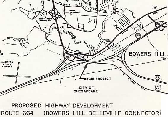 |
| The Bowers Hill
Interchange with the proposed I-664 heading to the north. The highway to
the left is US-13/US-58/US-460, to the upper right is I-264, and to the
lower right is I-64.
I only copied a portion of the map, as I wanted to show the layout of the Bowers Hill Interchange. This map comes from the Location Public Hearing brochure for the Bowers Hill - Belleville Connector, which was distributed to the public by the Virginia Department of Transportation, for the Location Public Hearings which were held November 17, 18 and 30, 1987, in the City of Chesapeake. |
Excerpts from the 1987 Location Public Hearing brochure for the Bowers Hill - Belleville Connector, (in blue text):
HISTORY
In 1965 Wilbur Smith and Associates, consulting engineers, published the Southeastern Regional Transportation Study which was prepared for the Southeastern Virginia Regional Planning Commission. The purpose of the study was to identify highway transportation needs through the year 1980 for the area of southeastern Virginia comprised of the cities of Chesapeake, Norfolk, Portsmouth, Suffolk and Virginia Beach. The proposed Bowers Hill - Belleville Connector project was a part of the 1965 study and has since been included in all updates of the Southeastern Regional Transportation Plan. In October 1982, the Southeastern Virginia Area Metropolitan Planning Organization approved the proposed project as part of its Regional Long-range Highway Needs Study.
By action of the Virginia General Assembly in 1964, the State Highway Commission was authorized to establish within the State Highway System an arterial network of highways to supplement and compliment the Interstate System. By this authority Routes17 and 17A were established as part of the arterial network. In September 1964 the Virginia Department of Highways was requested by a resolution adopted by the Council of the city of Chesapeake to proceed with the requisite surveys and plans for the arterial connection between Bowers Hill and existing Route 17 west of Churchland.
Following location studies by the Virginia Department of Highways, a Location Public Hearing was held on July 13, 1966. The location, which is generally along present Alternative "A", was concurred in by a resolution adopted by the Chesapeake City Council on August 23, 1966, approved by the Virginia Highway Commission on October 13, 1966, and by the Federal Highway Administration on December 19, 1966.
Since this approval, development of the project has continued with the design concept evolving from an at-grade arterial facility to a limited-access facility with grade separations and interchanges.
In accordance with the Agreement of March 6, 1984, between the Federal Highway Administration and the Virginia Department of Highways and Transportation, Federal-aid Primary Routes 121 and 2 from I-664 at the south shoreline of Hampton Roads to a junction with I-64 at the Bowers Hill Interchange shall be designated as a part of the Interstate System of Highways in Virginia when constructed to the geometric and construction standards for the Interstate System. The Bowers Hill - Belleville Connector, now designated State Route 664, is included within the limits of this agreement.
In order to conform to current Federal laws and Federal Highway Administration guidelines, the Department of Transportation determined that it would be necessary to consider alternative locations to avoid or minimize wetland impacts and hold an additional Location Public Hearing for the Bowers Hill - Belleville Connector.
PURPOSE OF THE LOCATION STUDY
The purpose of this preliminary study is to consider proposed corridor locations for Route 664 from the intersection of Routes 13, 58, and 460 (at Bowers Hill) in the city of Chesapeake to the intersection of Route 17 (at Belleville) in the city of Suffolk. The completion of the Bowers Hill - Belleville Connector will provide the final link in a continuous limited access interstate facility between I-64 in Hampton and I-264 and I-64 in the city of Chesapeake.
[end excerpts from location public hearing brochure]
Phase I of the Bowers Hill Interchange provided the upgrade to US-460/US-13/US-58, from the Hampton Roads Airport to I-64 and I-264, with 6 lanes on the main highway, a new pair of bridges over the railroad with 4 lanes and full shoulders on each directional bridge, plus grade separations and an interchange connection to US-58 Airline Boulevard; that completed the upgrade of US-58 and US-460 from the Suffolk Bypass to I-64/I-264. Provision for Phase II of the Bowers Hill Interchange was included in the design of Phase I, and Phase II was essentially the connection of I-664 and its local ramps into US-460/US-13/US-58. Phase II was completed in April 1992.
Application for Interstate 664 Designation
In October 1968, the Virginia Department of Highways (VDH) applied to the Federal Highway Administration (FHWA) for allocation of funds to complete 20.5 miles of Interstate Beltway, beginning near the junction of I-64 and the Newport News Connector Road, and running across Hampton Roads to a connection with I-64 near Bowers Hill in the City of Chesapeake. (This is very similar to what was eventually built). This project met the requirements of filling in breaks in the region's Interstate highway system.
The FHWA advised the state in December 1968 that its 20.5-mile request for Interstate funding was justified, but that an 11.3-mile section of I-64 then in the early design phase would have to be dropped from the Interstate system because of limitations on new mileage. This included the parallel Hampton Roads Bridge-Tunnel and the I-64 section between the Newport News Connector Road and the junction with I-564 in Norfolk. VDH filed a counterproposal which included this mileage and assigned the remaining 9.2 miles to a revised Outer Beltway concept. This was done because of the infeasibility of dropping that key 11.3-mile section of I-64 from the Interstate system.
The state's proposal recommended beginning the 9.2 miles of Interstate highway near the junction of I-64 and the Newport News Connector Road, and running across Hampton Roads, with the state assuming responsibility for funding the remaining distance to I-64 at Bowers Hill, built to limited-access standards. The FHWA accepted VDH's proposal in April 1971, and designated the northern 9.2 miles of the new road as Interstate 664.
The Virginia Department of Highways contracted with a consultant to conduct a corridor location study and prepare a draft environmental impact statement; this was completed in December 1972. Public hearings were held, and a variety of alignments were analyzed in a corridor about two miles wide. One alignment would have put the bridge-tunnel about a mile to the east of the selected alternative. Consideration was also made for routing the highway across the western edge of Craney Island, which seemed like a logical way to eliminate almost 2 miles of bridge, however, Craney Island is landfill created from spoil material dredged from the Hampton Roads area shipping channels over the years, and the landfill was not a very stable base for a road; so a bridge across it would have been necessary. The Virginia State Highway Commission selected the final location for I-664 on April 25, 1973, and directed that final design begin.
|
|
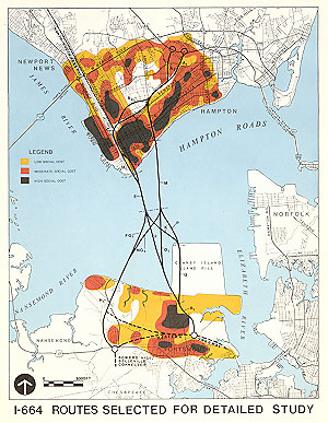
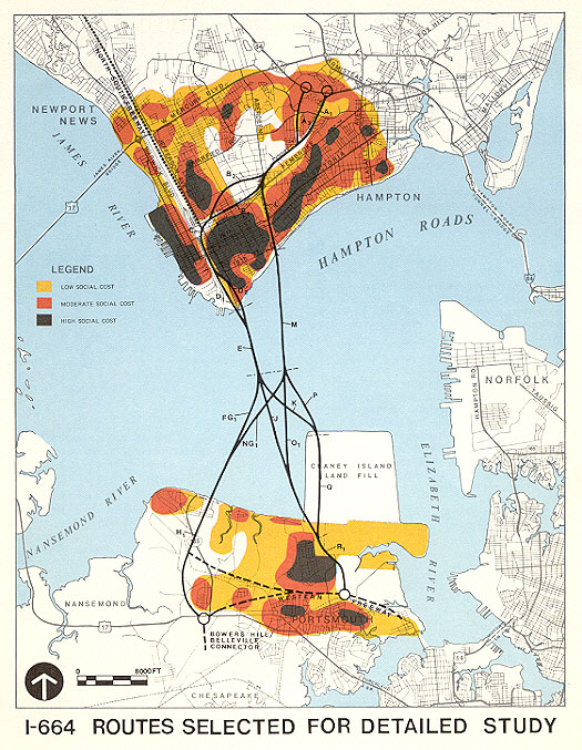
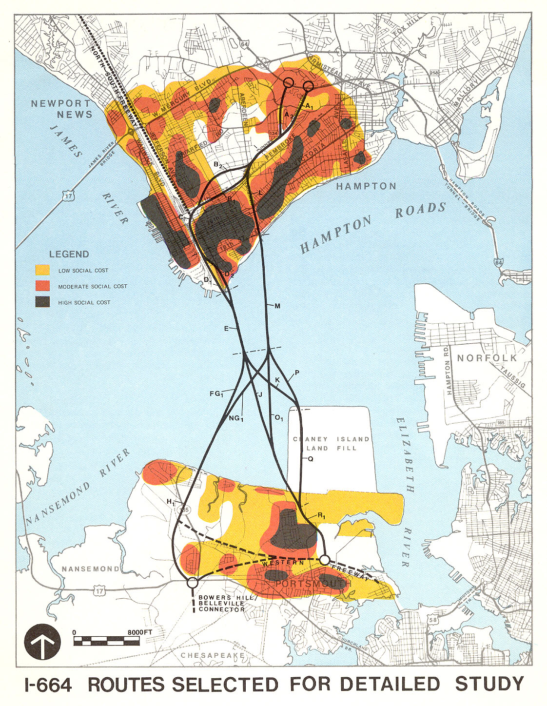
This map of I-664 routes selected for detailed study comes from the Location Hearing Information brochure, which was distributed to the public by the Virginia Department of Highways, for the Location Public Hearings which were held March 13 and 14, 1973, on the north and south sides of Hampton Roads respectively. The location that was chosen to be built was the western route, made up of route segments A1-B1-C-D1-E-FG1-H1 Click for larger map images: Medium (162K), Large (301K), Extra Large (740K). Use "Back" button to return. |
Traffic studies and projections for a 1995 design year for the western route, showed that six lanes was needed from I-64 in Hampton to downtown Newport News, and that four lanes would be adequate from there, southward across Hampton Roads, to I-64 at Bowers Hill in Suffolk.
|
|
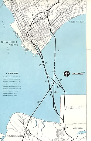
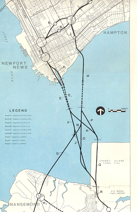
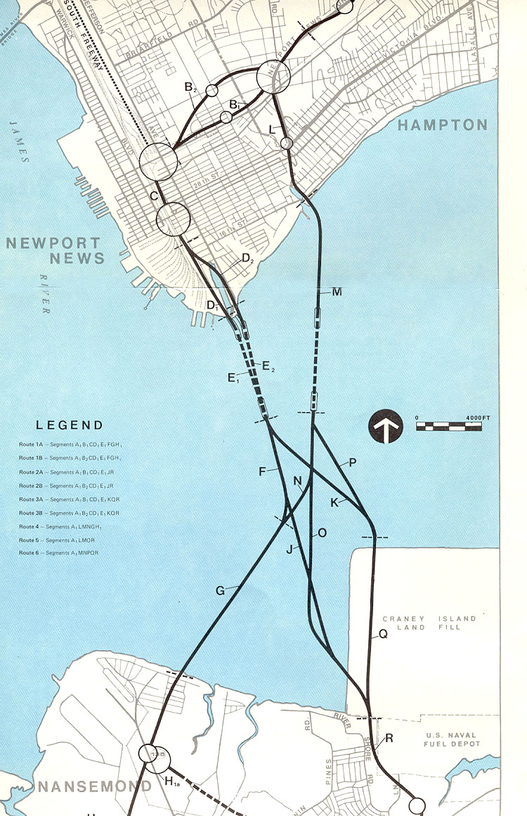
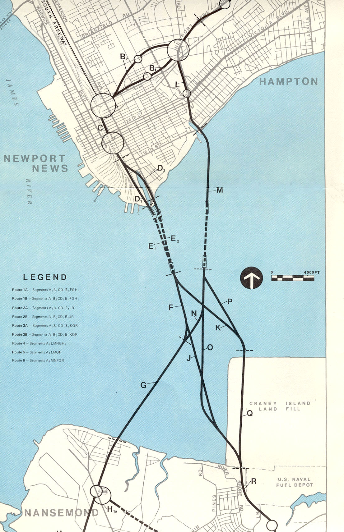
This map of I-664 routes selected for detailed study is from a larger map that shows more details of the bridge-tunnel and the area. It comes from the Location Hearing Information brochure, which was distributed to the public by the Virginia Department of Highways, for the Location Public Hearings which were held March 13 and 14, 1973, on the north and south sides of Hampton Roads respectively. The location that was chosen to be built was the western route, made up of route segments A1-B1-C-D1-E1-F-G-H1 Click for larger map images: Medium (120K), Large (249K), Extra Large (466K). Use "Back" button to return. |
Excerpts from Location Hearing Information brochure (in blue text):
PROJECT NEED - The project need was established by relating a "no-action" alternate to an earlier regional transportation study. This determined what the traffic demands will be on the Hampton Roads Bridge-Tunnel and the James River Bridge when they are projected to be four-lane toll-free facilities in the future, and permitted forecasting the nature and quantity of regional and local economic growth both with and without an additional water crossing. A third crossing will clearly be needed to relieve the traffic congestion that will result by the mid-1990's, and the study clearly shows it must be toll-free to generate the maximum economic impact.
SUMMARY OF REGIONAL CONSIDERATIONS - The expected regional effect will be beneficial on the whole, and positive for economic development, fiscal impact, national defense, relocation housing availability, transportation planning, and the general ecology of the area. The existing and projected transportation system will be improved, about 5% additional growth will occur in most categories, and the national defense capabilities will be improved. Major regional ecological problems are not foreseen, and the availability of relocation housing is expected to be good.
Concerning the effect of I-664 on regional land use patterns -
A new third crossing of Hampton Roads will create a shift in the future regional development pattern which will not otherwise occur. This shift will only slightly reduce the proportional share of growth and fiscal return projected to occur in Hampton, Newport News, and Portsmouth, while increasing the shares in Nansemond, Norfolk, and Chesapeake. This shift could be considered a minor negative impact for the first three cities.The U.S. Navy requested that the crossing be built as a bridge-tunnel combination with a tunnel under the main shipping channel. Their stance was that a high-level bridge would be a hazard to military operations during wartime. The Chesapeake Bay Bridge-Tunnel and the Hampton Roads Bridge-Tunnel were constructed as bridge-tunnels for exactly the same reason. Northrop Grumman Newport News (formerly Newport News Shipbuilding and Drydock Company) is upstream of the crossing, and it is the one U.S. shipyard that constructs and overhauls nuclear-powered aircraft carriers, and it also is one of two U.S. shipyards that builds submarines. The Virginia Department of Highways selected the bridge-tunnel scheme for the crossing.
Excerpt from Location Hearing Information brochure (in blue text):
A bridge-tunnel water-crossing was selected after preliminary studies as being superior to a high-level bridge crossing for national defense, navigational, and esthetic reasons. National defense reasons militate against a bridge because of the paralyzing effects on access to the Navy storage and shipbuilding yards should the bridge be severely damaged by enemy attack and dropped into the channel. A bridge will also be very prominent when elevated sufficiently to give adequate vertical clearance for shipping, and the approach grades on the north side will have to begin a mile or more from the shoreline to conform with Interstate design requirements.The western route (the one that was selected and constructed) from I-64 in Hampton to US-17 in Suffolk required right-of-way for the highway that necessitated the relocation of 130 residences and 15 businesses. Given the urban freeway nature of the route through Newport News, that amount of total relocations is fairly light. Most of the route in Newport News passes through commercial and industrial areas and part is adjacent to a mainline railroad corridor.
Sources: I-664 Final Environmental Impact Statement, prepared for Virginia Department of Highways, approved by USDOT on September 17, 1973. Location Hearing Information brochure, which was distributed to the public by the Virginia Department of Highways, for the Location Public Hearings which were held March 13 and 14, 1973, on the north and south sides of Hampton Roads respectively. Route 664 Design Study Report, which was distributed to the public by the Virginia Department of Highways and Transportation, for the Design Public Hearings which were held in December 1978.
Excerpt from Route 664 Design Study Report brochure (in blue text):
INTRODUCTION - In April, 1971, the Federal Highway Administration approved allocations for 9.2 miles of interstate highway in the Hampton Roads area. This section of highway is known as Interstate 664 and it begins at the intersection of Interstate 64 and the Newport News Connector Road and extends in a westerly direction to a point 1.7 miles north of the south shore of Hampton Roads. Subsequent to this approval, a corridor location study and draft environmental/section 4(f) statement were prepared. Location public hearings were held on March 13th and 14th, 1973 on the south and north sides of Hampton Roads respectively. On April 25, 1973, the State Highway and Transportation Commission approved the location of Interstate 664. The Federal Highway Administration approved the final environmental/section 4(f) statement on September 4, 1975 and the location on October 8, 1975. On March 6, 1978, the Federal Highway Administration approved additional allocations for 1.7 miles, extending Interstate mileage to the south shore of Hampton Roads. This project is a major link in the beltway connecting Route 64 near the existing Newport News Connector, running across Hampton Roads to a connection with Route I-64 near Bowers Hill.
REGIONAL AND COMMUNITY GROWTH - General Plans: The possibility of a new Hampton Roads crossing has been under study and discussed for over 15 years. The Peninsula Area Transportation Study completed in September of 1966 suggested investigating the possibility of a new crossing. The updated Proposed Thoroughfare Plan completed by the Newport News Planning Commission in 1968 considered a new crossing becoming the natural extension of the proposed North-South Freeway. The North-South Freeway is envisioned as extending from a junction with I-64 near Patrick Henry Airport in the northeasterly part of Newport News to 25th Street in the southerly part, generally along an alignment parallel to the Chesapeake and Ohio Railway tracks between Warwick and Jefferson Avenues.
Excerpts from Route 664 Design Study Report brochure (in blue text):
Total Transportation Requirements: The transportation plan for the Peninsula Region advocated an east-west expressway link which began at a connection with I-64 and the Newport News Connector Road and ran west to an intersection with the proposed North-South Freeway in Newport News. Such a link was proposed in the regional plan to both relieve congestion in the Newport News downtown shipbuilding area and facilitate access between the heavily populated sections of Newport News and Hampton.The overall history of I-664 from inception to the December 1978 publication date of the report:
Status of Planning Process: In October 1968 the Virginia Department of Highways applied to the Federal Highway Administration for allocation of funds to complete 20.5 miles of Interstate Beltway beginning near the junction of I-64 and the Newport News Connector Road and running across Hampton Roads to a connection with I-64 near Bowers Hill. This project met the requirements of filling in breaks in the region's Interstate System.
The Federal Highway Administration advised the State in December 1968 its 20.5 miles request for Interstate funding to complete the Outer Beltway around the metropolitan area was justified, but that an 11.3 miles section of I-64 then in the early design stage would have to be dropped from the Interstate System because of mileage limitations. This included the second tube of the Hampton Roads crossing and the section between the Newport News Connector and the junction with I-564 in Norfolk. The Virginia Department of Highways filed a counter-proposal which included this mileage and assigned the remaining 9.2 miles to a revised Outer Beltway concept. This was done because the I-64 plans had been underway for some time, commitments were already made to the involved communities. Substantial financial resources were already devoted to land acquisition, and the extent of involvement and the projected needs made it impossible to abandon the project.
The State's revised proposal recommended beginning the 9.2 miles of Interstate Highway (now designated I-664) at a point near the Newport News Connector Road intersection with I-64 in the City of Hampton. From this point, the 9.2 mile allocation ran along the most desirable corridor to Hampton Roads. This was accepted by the Federal Highway Administration in April, 1971. On March 6, 1978 the Federal Highway Administration approved allocations for an additional 1.7 miles, extending interstate mileage to the south shore of Hampton Roads. Under the terms of this proposal, the State will assume responsibility for completing the approximately 9.3 mile connection between the end of the 10.9 mile allocation and I-64 near Bowers Hill in accordance with limited access road standards.
[end excerpts from location and design public brochures]
The following information is from personal notebooks and knowledge.
Federal Interstate Highway Funding Secured for Whole Corridor
The 9.2-mile Interstate allocation actually did not cross Hampton Roads fully. It included the manmade North Island and South Island, and the underwater tunnel, and the northern 1.5 miles of the 3.2-mile-long South Trestle. The state applied to FHWA for Interstate funding for the south section of the South Trestle in 1978, and the request was approved for another 1.7 miles of I-664, extending I-664 to the south shoreline of Hampton Roads.
In 1983, the state applied to FHWA for permission to use some of its Interstate 4R funds to fund the remaining 9.4 miles from the Hampton Roads shoreline to I-64 at Bowers Hill. Interstate 4R funds are normally allocated to existing Interstate highways for reconstruction, rehabilitation, restoration, and resurfacing (but that program was modified with the ISTEA federal 6-year transportation bill of 1991). The FHWA approved this request.
I have a copy of a 1984 VDOT letter with the Section 139(b) Agreements between VDOT and FHWA, for the addition of I-664 south of Hampton Roads, and I-895, to the Interstate system. A federal Section 139(b) Agreement (at least as performed back then) provided for the designation of new Interstate mileage, but with the specification, "The designation of a highway as part of the Interstate System under this section shall create no Federal financial responsibility with respect to such highway". (Quote is from attached copy from the U.S. Code). In other words, if the highway is built to Interstate standards, and the state DOT and FHWA consider it to be a logical addition to the Interstate system, then this agreement could be used to designate the highway as an Interstate highway, but without FHWA having the responsibility to fund 90% of the highway's construction (and right-of-way acquisition), contrary to the rule for the original Interstate system mileage which was built with 90% FHWA funding. However, this didn't prevent the state from the possibility of using some other form of FHWA federal aid allocations to build the highway, as was the case with I-664 south of Hampton Roads, which was built with 90% FHWA Interstate 4R reconstruction funds.
So I-664 was a continuing saga of finding the 90% federal Interstate funding to build the entire 20.7-mile-long beltway corridor from I-64 in Hampton to I-64 at Bowers Hill. The state paid for the remaining 10%.
Construction of Interstate 664
The first I-664 contract award was in 1979 and it involved the semi-directional interchange with I-64 in Hampton and about a mile of I-664 mainline. The interchange is near the Hampton Coliseum, and much of it is on bridge structure over wetlands. This interchange is on the same location as was the Newport News Connector Road interchange, and I-664 utilized the right-of-way of the NNCR, along with additional needed right-of-way since the 6-lane width of I-664 is much wider than the 2-lane width of the NNCR. The I-664 interchange provides for full movements to and from both directions of I-64, and its design will accommodate a future arterial extension of I-664 to the junction of Mercury Boulevard and Armistead Avenue, along with full 4-way ramp connections at the I-64/I-664/arterial interchange.
Construction contract awards progressed southward from the north end of I-664. Newport News anticipated the entry of I-664 into the downtown area, because I-664 would in effect provide an Interstate spur from I-64, enhancing access to the downtown, even before the Hampton Roads crossing was finished.
I-664 has an interchange complex with several major thoroughfares in downtown Newport News. Actually, I-664 runs parallel to and just east of the CSX Transportation (old C&O) railroad corridor and yard. Downtown Newport News borders the west side of the railroad corridor. The railroad serves the Newport News Marine Terminal and the collier docks (for coal cargo ships) near the southern tip of Newport News. I-664's southernmost interchange in Newport News junctions with the Harbor Access Road, near the marine terminal.
The I-64/I-664 interchange and 1.2 miles of I-664 in Hampton was completed and opened on June 25, 1981. The next 2.6 miles between that first section and Roanoke Avenue in Newport News opened in December 1983. The next 1.1 miles between that second section and 35th Street in Newport News opened in September 1987. The next 0.3 miles between 35th Street and 26th Street in Newport News opened in January 1988. The 1.1 miles between 26th Street and Terminal Avenue near the Small Boat Harbor in Newport News opened in January 1991. The 7.1-mile-long section from US-13/US-58/US-460 at Bowers Hill to VA-135 was opened in January 1992, and the 6.2-mile-long section final section across Hampton Roads, which included the 4.6-mile Monitor-Merrimac Memorial Bridge-Tunnel (MMMBT), was opened on April 30, 1992. The 1.1 mile of US-13/US-58/US-460 was upgraded to a freeway in the Bowers Hill area of Chesapeake and it connects I-664 to I-64 and I-264, and it was completed in 1982, and it was signed as part of I-664 when I-664 was completed in April 1992. The high-speed directional interchange that connects I-664 to I-64 and I-264 was opened in 1969 as part of the terminal I-64/I-264 interchange; and the ramps connecting I-664 to I-64, and I-664 to I-264, were widened from 1 lane to 2 lanes in 1993. Sources: Lengths and opening dates from Interstate System Opened to Traffic as of July 1, 1992, by Virginia Department of Transportation.
In 2002, I-664 in Virginia has 6 lanes for 4.9 miles from I-64 in Hampton to 35th Street in Newport News, and 4 lanes for next 14.7 miles to US-58 in Chesapeake, and 8 lanes for the 1.1 mile from US-58 to I-64/I-264.
The MMMBT cost $400 million, and it includes a four-lane tunnel that is 4,800 feet long, two man-made portal islands (the North Island and the South Island), 3.2 miles of twin trestle (the South Trestle), and the 0.9-mile North Approach Bridge. The North Island is actually connected to the tip of Newport News, and the North Approach Bridge is an elevated land viaduct with its south abutment on the North Island. A nice feature is the fact that the MMMBT is toll-free. The name comes from the fact that the duel between the two Civil War ironclads was fought less than a mile from the where the tunnel is today. The entire 20.7-mile-long I-664 corridor cost $700 million for planning, design, right-of-way and construction.
With the completion of I-664, downtown Newport News has easy Interstate access to the South Hampton Roads cities of Portsmouth, Norfolk, Chesapeake, and Suffolk. I-664 provides easy access between the Peninsula cities of Newport News and Hampton, and the western South Hampton Roads cities. The James River Bridge (US-17) provided this corridor previously, but the route is 8 miles longer than the I-664 route, and US-17 is a four-lane arterial with high-level two-lane bridges at the Nansemond River and Chuckatuck Creek. The old two-lane James River Bridge was opened in 1928 along with the original Nansemond River and Chuckatuck Creek bridges. The James River Bridge was replaced in stages from 1975-1982, with four lanes available in 1982; and the new Nansemond River Bridge was opened in 1982 and the new Chuckatuck Creek Bridge was opened in December 1988.
10-Year Anniversary for Completion of Interstate 664
"Our best secret? The Monitor-Merrimac was designed to help ease traffic at
the Hampton Roads Bridge-Tunnel, but fewer motorists than hoped are using it",
article by the newspaper Hampton Roads Daily Press, April 28, 2002.
(excerpts in blue text):
The article goes on to say that traffic on the Hampton Roads Bridge-Tunnel (HRBT) decreased by 7 percent in the months after the opening of the Monitor-Merrimac, and then it quickly rebounded. A VDOT highway planner, Frank Dunn, said that VDOT pretty much knew that the MMMBT wasn't going to have much impact on the traffic on the Hampton Roads Bridge-Tunnel. The Monitor-Merrimac connects to what was a largely undeveloped area of Suffolk in the early 1990s. Unlike the HRBT, the Monitor-Merrimac is not a direct route to popular destinations such as downtown City of Norfolk and Naval Station Norfolk.
The article goes on to say that the regional highway landscape was much different in the Hampton Roads region when I-664 was in the planning stages in 1970. The Hampton Roads Bridge-Tunnel was a single bridge-tunnel with only two lanes and it had a $1.25 toll, which limited traffic to about 17,000 vehicles per day, and I-64 in South Hampton Roads was a stretch of incomplete highway that did not connect like it does today. The Hampton Roads Bridge-Tunnel dumped traffic onto US-60 in Ocean View, not onto the Interstate. In 1970, VDOT planned to handle the area's immediate traffic needs by vastly improving Interstate 64 and by adding a parallel span to the HRBT. When the parallel span of the HRBT opened in 1976 and VDOT eliminated the toll, that competed I-64 throughout the Hampton Roads area, and people started using I-64 in unprecedented numbers. The traffic increases on the Hampton Roads Bridge-Tunnel after 1976 were far in excess of what the traffic planners envisioned, a level of success that today often means that there is traffic congestion at peak hours. However, traffic on the US-17 James River Bridge dropped nearly 25 percent between 1992 (the year that the MMMBT opened) and 1995, and in 2002 it is still below what it was in 1992. The article concludes by quoting Dunn as saying that I-664's completion diverted a lot more traffic from the James River Bridge than it did from the HRBT.
"Monitor-Merrimac helps keep Newport News alive, article by the newspaper
Hampton Roads Daily Press, April 28, 2002. (excerpt in blue text):
"Tunnel key to Third Crossing plan", article
by the newspaper Hampton Roads Daily Press, April 28, 2002. (excerpt
in blue text):
The Monitor-Merrimac Memorial
Bridge-Tunnel is still a baby compared to the other local crossings that celebrate
milestone anniversaries this year. The Monitor-Merrimac turns 10, the Midtown
Tunnel turns 40, and the Downtown Tunnel turns 50. But in the future, the
Monitor-Merrimac is poised to be the Big Daddy of them all - at least in size.
As part of the Third Crossing proposal, the Virginia Department of Transportation
plans to add a six-lane bridge-tunnel parallel to the Monitor-Merrimac. The new
crossing would add four lanes of general traffic and the equivalent of two lanes
for mass transit or high-occupancy vehicles. If VDOT finds $4.4 billion to pay
for the Third Crossing, it plans to start construction in 2005 and finish in 2014.
Construction contractors that are courting VDOT for the job say they could build
the Third Crossing for millions less and open it in 2009. Four lanes of the new
bridge-tunnel would handle southbound traffic. All four lanes of the current Monitor-Merrimac
would become northbound, said Jeff Cutright, the acting project representative
for the Third Crossing. Near the Suffolk shore, an interchange over the James
River would allow drivers to either continue heading north or south, or branch
off to the east. That leg of the Third Crossing would carry drivers through bridges
and two sets of tunnels under the Elizabeth River before connecting with Interstate
564 in Norfolk, Cutright said.
The VDOT cost estimate for the Third Crossing was $2.7 billion in 2000 dollars. Public-private proposals have proposed building it much sooner and for much less than the $4.4 billion which represents the cost inflated out to a 2014 completion date. See my article Hampton Roads Crossing Study for more details. The above newspaper article goes on to cite Jeff Cutright as saying that it is not yet known whether the Third Crossing would be called the Monitor-Merrimac or whether it will have a new name. VDOT predicts that once the Third Crossing is opened, that the traffic volume will be 17 percent lighter on the I-64 Hampton Roads Bridge-Tunnel than it will be without the project.
I-664 Final Environmental Impact Statement, prepared for Virginia Department of Highways, approved by USDOT on September 17, 1973. Location Hearing Information brochure, which was distributed to the public by the Virginia Department of Highways, for the Location Public Hearings which were held March 13 and 14, 1973, on the north and south sides of Hampton Roads respectively. Route 664 Design Study Report, which was distributed to the public by the Virginia Department of Highways and Transportation, for the Design Public Hearings which were held in December 1978. Newspaper articles as cited above.
Copyright © 1997-2004 by Scott Kozel. All rights reserved. Reproduction, reuse, or distribution without permission is prohibited.
By Scott M. Kozel, Roads to the Future
(Created 12-20-1997, last updated 6-15-2004)